Showing 182 items
matching hustlers reef
-
 Bendigo Historical Society Inc.
Map - K. K. MINE - TRANSVERSE SECTION K. K. MINE
... Transverse Section of the K. K. Mine on the Hustler's Line.... Mine Hustler's Line of Reefs Geological Survey of Victoria H S ...Transverse Section of the K. K. Mine on the Hustler's Line of Reefs, Bulletin No 33, Plate No XXXII. Map shows the different levels and their depth. Also the different types of stone encountered and geological features such as spurs and faults. Has drawing of the poppet legs at the top of the shaft and sill of shaft 773.56 ft above sea level.Map has Geological Survey of Victoria crest and signed by H S Whitelaw, Underground Survey Office Bendigo, September, 1913. This item has not been scanned or photographed.cottage, miners, fortuna hustler's mine, transverse section of k. k. mine, hustler's line of reefs, geological survey of victoria, h s whitelaw -
Bendigo Historical Society Inc.
Photograph - PURDY COLLECTION: PALL MALL PHOTO
... 'Royal Reserve G.M., Hustlers line of reef, Pall Mall, Bendigo.'.... On back of image in biro 'Royal Reserve G.M., Hustlers line ...Sepia image of Pall mall, taken from just south of the Alexandra Fountain. Shows horse drawn vehicles, people walking. Women dressed in long dresses, tramline on road, tram heading up towards View Street. Poppet head and mining chimney of Royal Reserve mine on LH side of Pall Mall. Post Office and Shamrock buildings on either side in mid-ground. On back of image in biro 'Royal Reserve G.M., Hustlers line of reef, Pall Mall, Bendigo.'bendigo, streetscape, pall mall -
 Bendigo Historical Society Inc.
Map - GREAT EXTENDED HUSTLER'S MINE - PLAN OF THE GREAT EXTENDED HUSTLER'S MINE
... Plan of the Great Extended Hustler's Mine on the Hustler's... MINING Parish Map Great Extended Hustler's Mine Hustler's Line ...Plan of the Great Extended Hustler's Mine on the Hustler's Line of Reefs, Bendigo. Bulletin No 33, Plate No X. Lease No 7382. Plan has map of streets. Mine was located in the block bounded by Langston and Anderson Streets and was between the Hustler's Anticline at Surface and the Lightning Hill Anticline at Surface. Latham & Watson's Shaft is also mentioned. Levels are numbered and a table shows the Levels and their Depths. Geological Survey of Victoria. Signed by H A Whitelaw, Underground Suyrvey Office, Bendigo, September 1913. This item has not been scanned or photographed.mining, parish map, great extended hustler's mine, hustler's line of reefs, mining lease no 7382, geological survey of victoria, underground survey office bendigo, h a whitelaw, latham & watson's shaft -
 Bendigo Historical Society Inc.
Map - FORTUNA HUSTLER'S MINE - LONGITUDINAL SECTION OF THE FORTUNA HUSTLER'S MINE
... on the Hustler's Line of Reef, Bendigo. Bulletin No 33, Plate No IV... Underground Survey Office Bendigo Hustler's Line of Reef Hustler's ...Longitudinal Section of the Fortuna Hustler's Mine on the Hustler's Line of Reef, Bendigo. Bulletin No 33, Plate No IV. Shows poppet legs at the surface level, Datum Line 750 feet above Sea Level, levels and their depths, the amount of gold per ton and some geographical features. Geological Survey of Victoria emblem and signed by H A Whitelaw, Underground Survey Office, Bendigo. Note - Plates 4, 8, 13, 20, 26 & 31 form a Longitudinal Section from Fortuna Hustler's to Hustler's Consols Mine. This item has not been scanned or photographed.mining, parish map, fortuna hustler's mine, longitudinal section of the fortuna hustler's mine, geological survey of victoria, h a whitelaw, underground survey office bendigo, hustler's line of reef, hustler's consols mine -
Bendigo Historical Society Inc.
Map - HUSTLER'S ROYAL RESERVE NO 2 CO - TRANSVERSE SECTION OF THE HUSTLER'S ROYAL RESERVE NO 2 CO
... Mine on the Hustler's Line of Reef Bendigo, Bulletin No 33... of the Hustler's Royal Reserve No 2 Co Mine on the Hustler's Line of Reef ...Transverse Section of the Hustler's Royal Reserve No 2 Co Mine on the Hustler's Line of Reef Bendigo, Bulletin No 33, Plate No VII. Section shows the poppet legs and the sill of Shaft at 707.65 ft above sea level, depth of levels, stone encountered and geological features. Geological Survey of Victoria emblem. H. Herman Director, W. Dickson Secretary of Mines and The Hon. J. Drysdale Brown MLC, Minister of Mines. Signed by H S Whitelaw, Underground Survey Office Bendigo, September 1913. This item has not been scanned or photographed.mining, parish map, hustler's royal reserve no 2 co, transverse section of the hustler's royal reserve no 2 co, h s whitelaw, undergrou;nd survey office bendigo, geological survey of victoria, h herman, w dickson, the hon. j drysdale brown mlc -
Bendigo Historical Society Inc.
Map - HUSTLER'S ROYAL RESERVE NO 2 (PARK SHAFT.) - TRANSVERSE SECTION OF THE HUSTLER'S ROYAL RESERVE NO 2
... (Park Shaft.) on the Hustler's Line of Reef. Bulletin No 33... MLC Hustler's Line of Reef Transverse section of the Hustler's ...Transverse section of the Hustler's Royal Reserve, No 2 (Park Shaft.) on the Hustler's Line of Reef. Bulletin No 33, Plate No IX. Section shows poppet legs and sill of shaft at 755.70 ft above sea level, depth of levels, type of stone encountered including lava and geological features. Geological Survey of Victoria emblem and beneath it H. Herman, Director, W. Dickson, Secretary of Mines and The Hon. J. Drysdale Brown MLC Minister of Mines and signed by H S Whitelaw, Underground Survey Office, Bendigo September, 1913.mining, parish map, hustler's royal reserve no 2 (park shaft.), transverse section of the hustler's royal reserve no 2 (park shaft.), h s whitelaw, underground survey office bendigo, geological survey of victoria, h herman, w dickson, the hon j drysdale brown mlc, hustler's line of reef -
Bendigo Historical Society Inc.
Document - ALBERT RICHARDSON COLLECTION: BLACK FOREST COMPANY
... about the Black Forest Gold Mine on the Hustler's line of reef... on the Hustler's line of reef. The Black Forest mine was situated one mile ...Five page handwritten and typed document with information about the Black Forest Gold Mine on the Hustler's line of reef. The Black Forest mine was situated one mile north of the Eaglehawk Post Office. To the west was the South New Moon on the Garden Gully line of reef and to the east was the Lightning Hill line of reef worked by open cutting to a depth of over 100 ft by Pascoe and Simonds. A party of Germans named 'Rothacker and Party', first worked the claim on the Black Forest mine approx 1860. Other mines worked on the Hustler's line north of the Black Forest were: Martha Company. Johns and company and Meaner (unclear) and Co.bendigo, mining, black forest gold mine -
 Bendigo Historical Society Inc.
Document - LANSELL RELATED DOCUMENTS
... ., Lansell's Comet, Cornish United Co., Ironbark Co., Hustler's Reef Co...., Lansell's Comet, Cornish United Co., Ironbark Co., Hustler's Reef Co ...Document.Copy of Williamstown Historical Society Newsletter No 17 (1977).On the second and third page of this Newsletter is an article entitled ''The guns of the 'Nelson''', written by Doug Mills, Castlemaine. The Warship NELSON underwent alterations in 1860, including cut down to two decks and lengthened, her armaments reduced to 72 guns. Two 7inch 68 pounder guns were added to her armament. In February 7 1867 she was officially given to the Colony of Victoria by the Imperial Government. At the time her Commander was Captain Charles B. Payne. The Warship reached Melbourne in 4th February 1868. Relics of the NELSON were auctioned at Williamstown Victoria Naval Depot, and her two anchors are preserved for public display at Williamstown. An active demand for a share of the guns from various towns in the State. Ballarat received four (4) guns, Bendigo and Castlemaine two (2) each, while one has been given to each of the following towns: - Ararat, Tarnagulla, Hamilton, Bacchus Marsh, Echuca and Geelong. Collection of Lansell related documents: a. Copy of photograph - Lansell's Big 180 Victoria Hill - early 1870s - New Chum Hill in background. B. Lansell Estate mines - compiled from the annual report of the Hon Minister of Mines for Victoria, 1906. A listing of the George Lansell Mining Company interests at the time of his death. These were, New Moon Co, N.L., Clarence, New Prince Of Wales Co. N.L., Virginia G. M. Co., Catherine Reef United Co N.L., Great Northern Co N.L., Williams United, McDuff Amalgamated Co, South Mungo Co, South Prince Of Wales Consolidated, Constellation Co. Golden Pyke Co, Johnson's Reef Extended Company, Golden Age Co., Princess Dagmar Co, New St Mungo Co, Johnson's Reef Co, North Johnson's Co, Collman and Tacchi Co, Confidence Extended Co, G. Lansell Sandhurst Mines, Pearl Co., Windmill Hill Co., United Hustlers and Redan, Koch's Pioneer Co., Hercules and Energetic Co., Lansell's Comet, Cornish United Co., Ironbark Co., Hustler's Reef Co., and No. 1 Lansell's 83, Carlisle Co., Great Extended Hustler's Co., Victoria Consolidated Co., Great Central Victoria Co., Victoria Quartz Co., Victory and Pandora , Lansell's Big 180, Tambour Major, New Chum and Victoria Co., Garden Gully United Co., G. Lansell, Lansell's 222, Lazarus Co., Sea Amalgamated Co., Hustler's Royal Reserve Co., Horwood and Burrowe's Co., New Chum Consolidated Co., G Lansell's Sheepshead, Gariboldi Co., Londonderry Co., Shamrock Co., Great Britain Co., Fortuna Hustler's Co., Eureka Extended Co., G. Lansell's G.V.L., New Red White and Blue Consolidated, Great Southern Co., Lansell's Concord Mines, True Blue Co., G. G. Consolidated Co., Extended Red White and Blue Co., Great Columbian, Sedgwick and New Birthday. Also, a listing: ''Among the biggest yields to ate (sic) (date?) in ozs or Pounds were''; New Moon.Co. N.L. 180,087 ounces, Clarence £303,932, Catherine Reef United N.L. £762,815, Great Northern Co Ltd £394,525, Johnson's Reef Co 277,320ounces, Windmill Hill Co. 113,842ounces, Hustler's Reef Co. And No.1 1,144,923ounces, Carlisle Co 307,835ounces, Great Extended Hustlers Co £1,038,125, Garden Gully United Co. £1,653,900, Great Southern 97,752ounces, New Chum Consolidated 89,526ounces. This part (b) has handwritten inscription ''compiled by J Sarvaas MCE(??) Certified Mining Surveyor; 22/8/06''; c. Copy of Deed dated Dec 1886 between George Lansell, Wooten Lansell and the Bank of New South Wales relating to a wall and windows and openings etc etc. (3 pages of legalese!!!!!). Also, a (related?) page copy of a Grant -by purchase to the Bank of New South Wales with a date of August 1855 on it ''Enrolled in the Office of the Registrar of the Supreme Court of the Colony of Victoria - signed by Acting Registrar.document, gold, mines -
 Bendigo Historical Society Inc.
Document - WINDMILL HILL - PRODUCTION STATISTICS
... Extended, Extended Hustlers, Carlisle, Garden Gully, Johnsons Reef... Extended Extended Hustlers Carlisle Garden Gully Johnsons Reef ...Handwritten copy of production statistics from Windmill Hill. Some of the Miners were: Sullivan and his sons, Lindsay and Taylor, Thorpe & Co and Mr Lansell. The mines mentioned are: Confidence Lease, Central Windmill, Cinderella Claim,Confidence Extended, Extended Hustlers, Carlisle, Garden Gully, Johnsons Reef, United Hustlers & Redan, North Johnsons and United Devonshire. Also a piece of paper (b) with Johnsons Group See Annals of Bendigo 1872. Page 140. Document from Albert Richardson Collection of mining history.gold, windmill hill, windmill hill, production statistics, sullivan and his sons, lindsay and taylor, thorpe & co and mr lansell, confidence lease, central windmill, cinderella claim, confidence extended, extended hustlers, carlisle, garden gully, johnsons reef, united hustlers & redan, north johnsons and united devonshire. a m s special edition 1/6/1899 page 47, annals of bendigo 1872 page 140, albert richardson -
Bendigo Historical Society Inc.
Map - GREAT EXTENDED HUSTLER'S MINE - TRANSVERSE SECTION OF THE GREAT EXTENDED HUSTLER'S MINE
... on the Hustler's Line of Reef. Bulletin No 33, Plate No XII. Shows Poppet... Extended Hustler's Mine on the Hustler's Line of Reef. Bulletin ...Transverse Section of the Great Extended Hustler's Mine on the Hustler's Line of Reef. Bulletin No 33, Plate No XII. Shows Poppet legs at the surface and Sill of Shaft at 788.99 feet above Sea Level, Cross Cuts and their depths, stone and geographical features encountered and their references and a number of enlarged drawing of sections of the cross cuts, Geological Survey of Victoria emblem and signed by H A Whitelaw, Underground Survey Office Bendigo, September 1913. The depths of crosscuts to No 21 were taken from plans of surveys by Mr Walker and Mr Craven, noted under Reference. Another note: This Saddle Reef is sketched from Mr Walker's plan. Dividends amounting to 360,000 pounds were obtained from it. This item has not been scanned or photographed.mining, parish map, great extended hustler's mine, transverse section of the great extended hustler's mine, old shaft, mr walker, mr craven, geological survey of victoria, underground survey office bendigo, h a whitelaw -
Bendigo Historical Society Inc.
Map - GREAT EXTENDED HUSTLER'S MINE - LONGITUDINAL SECTION OF THE GREAT EXTENDED HUSTLER'S MINE
... on the Hustler's Line of Reefs. Bulletin No 33, Plate No XIII. Map shows... Hustler's Mine on the Hustler's Line of Reefs. Bulletin No 33, Plate ...Longitudinal Section of the Great Extended Hustler's Mine on the Hustler's Line of Reefs. Bulletin No 33, Plate No XIII. Map shows the Hustler's Tribute, 2 Old Shafts, Great Extended Hustler's Shaft, Latham & Watson's Shaft and Ironbark Gully. Datum Line 750 feet above Sea Level. Poppet Legs on the surface and Sill of Shaft 788.99 feet above Sea Level. Levels and their depths are shown and some geographical features. Some amounts of gold mined mentioned. Geological Survey of Victoria emblem and signed by H A Whitelaw, Underground Survey Office Bendigo, September 1913. Note - Plates 4, 8, 13,20, 26 & 31 form a Longitudinal Section from Fortuna Hustlers to Hustler's Consols Mine. This item has not been scanned or photographed.mining, parish map, great extended hustler's mine, longitudinal section of the great extended hustler's mine, geological survey of victoria, underground survey office bendigo, h a whitelaw, hustler's tribute, old shaft, great extended hustler's shaft, latham & watson's shaft, ironbark gully -
Bendigo Historical Society Inc.
Map - HUSTLER'S ROYAL RESERVE NO 2 MINE - PLAN OF THE HUSTLER'S ROYAL RESERVE NO 2 MINE
... Hustler's Freehold on the Hustler's Line of Reefs. Also mentioned... Hustler's Line of Reefs Lightning Hill Line of Reefs Plan ...Plan of the Hustler's Royal Reserve No 2 Mine Bulletin No 33, Plate No V. Plan shows the Hustler's Royal Reserve No 2 (Main Shaft), Hustler's Royal Reserve No 2 (Park Shaft.), the Royal Hustler's, the Imperial Hustler's and the Extended Hustler's Freehold on the Hustler's Line of Reefs. Also mentioned is the Lightning Hill Line of Reefs. Map shows some of the levels, approximate boundary of lease and the boundary of Lease No 8892 and 8897. There are also street names and the locations of jail, lagoons, Post Office, Rosalind Park and the State School, High School and Continuation School. Geological Survey of Victoria emblem. H. Herman Director, W. Dickson, Secretary of Mines and The Hon. J. Drysdale Brown MLC, Minister of Mines. Signed by zh Whitdan, Underground Survey Office, Bendigo, September 1913.mining, parish map, hustler's royal reserve no 2 mine, plan of the hustler's royal reserve no 2 mine, hustler's royal reserve no 2 (main shaft), hustler's royal reserve no 2 (park shaft), royal hustler's, imperial hustler's, extended hustler's freehold, geological survey of victoria, h herman, w dickson, the hon j drysdale brown, h whitdan, hustler's line of reefs, lightning hill line of reefs -
Bendigo Historical Society Inc.
Document - ALBERT RICHARDSON COLLECTION: GREAT EXTENDED HUSTLERS, TRIBUTE
... Extended Hustlers mine on the Hustlers line of reef. Formed... BENDIGO Mining great extended hustlers Four page typed document ...Four page typed document with information on the Great Extended Hustlers mine on the Hustlers line of reef. Formed in 1865 closed down in 1925. The mine was located a little to the south of the intersection of Hustlers Road and Anderson Street, North Bendigo. The mine plant and overall history of the mine is detailed in the document. The poppet head was steel, 70 ft high. Rear legs set on top of low mullock heap. Gold was first discovered here in 1853 by Jonathan Harris, who was later joined by two coloured men to whom he later sold out. They in turn sold out to a one armed man, J. Hustler and Messrs Latham and Watson. The poppet heads of the Great Extended Hustlers were later removed and the extra 15 ft of the front lets cut to the Stanfield mine at Long Gully. From there to the Wattle Gully Mine at Chewton.bendigo, mining, great extended hustlers -
Bendigo Historical Society Inc.
Map - HUSTLER'S ROYAL RESERVE NO 2 CO. - LONGITUDINAL SECTION OF THE HUSTLER'S ROYAL RESERVE NO 2 CO
... . on the Hustler's Line of Reef Bulletin No 33, Plate No VIII. Note - Plates... No 2 Co. on the Hustler's Line of Reef Bulletin No 33, Plate ...Longitudinal Section of the Hustler's Royal Reserve No 2 Co. on the Hustler's Line of Reef Bulletin No 33, Plate No VIII. Note - Plates 4, 8, 13, 20, 26 & 31 form a Longutudinal Section from Fortuna Hustler's to Hustler's Consols Mine. Mines mentioned are the Hustler's Royal Reserve No 2 Main Shaft, Hustler's Royal Reserve No 2 Park Shaft, Royal Hustler's, Imperial Hustler's, Great Extended Hustler's Freehold and the Great Extended. Section shows depth of levels, datum lines and height of sill above sea levelyield in ozs od gold. Geological Survey of Victoria emblem. H. Herman, Director, W. Dickson, Secretary for Mines and The Hon. J. Drysdale Brown MLC, Minister for Mines and signed by H S Whitelaw, Underground Survey Office Bendigo, September 1913. This item has not been scanned or photographed.mining, parish map, hustler's royal reserve no 2, longitudinal section of the hustler's royal reserve no 2 co, hustler's royal reserve no 2 (main shaft), hustler's royal reserve no 2 (park shaft), royal hustler's, imperial hustler's, great extended hustler's freehold, great extended, geological survey of victoria, underground survey office bendigo, h s whitelaw, h herman, w dickson, the hon j drysdale brown -
 Bendigo Historical Society Inc.
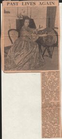
Newspaper - HARRIS COLLECTION: PAST LIVE AGAIN
... (her husband was the founder of the Hustlers' line of reefs... (her husband was the founder of the Hustlers' line of reefs ...A newspaper cutting "Past Lives Again" - The past will live again when the Bendigo and District branch of the Royal Historical Society of Victoria holds its Golden Days Exhibition at the Memorial Hall Next Friday, Saturday, Monday, Tuesday and Wednesday. many treasures of yesteryear have been resurrected from attics and storage chests. Among these the glorious royal blue silk brocade gown worn by Jennifer Wyatt. the frock was brought out from England more than 110 years ago by Mrs. Jonathan Harris of Axedale (her husband was the founder of the Hustlers' line of reefs in Bendigo). This paper clip is inside an envelope addressed to L J Ellison, Axedale Bendigo Vic. A postage stamp of 5d posted in Sydney 20 Sep 1960. No return address . In blue pen across "Harris dress picture".newspaper, bendigo -
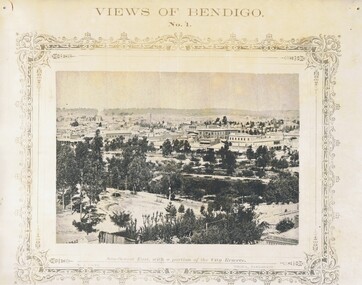
![View of portion of the City of Sandhurst, as seen from the hill, Camp Reserve / [by] Nicholas Caire, circa 1876](/media/collectors/550653872162f11fb04854aa/items/57774295d0cdd10a5c0eb588/item-media/57774325d0cdd10a5c0f0b71/item-fit-380x285.jpg) Kew Historical Society Inc
Kew Historical Society IncPhotograph, Anglo-Australasian Photographic Company, View of portion of the City of Sandhurst, as seen from the hill, Camp Reserve, c. 1876
... to be on the Hustler's line of reef. St. Paul's Church tower may be seen... to be on the Hustler's line of reef. St. Paul's Church tower may be seen ...Nicholas Caire was born on Guernsey in the Channel Islands in 1837. He arrived in Adelaide with his parents in about 1860. In 1867, following photographic journeys in Gippsland, he opened a studio in Adelaide. From 1870 to 1876 he lived and worked in Talbot in Central Victoria. In 1876 he purchased T. F. Chuck's studios in the Royal Arcade Melbourne. In 1885, following the introduction of dry plate photography, he began a series of landscape series, which were commercially successful. As a photographer, he travelled extensively through Victoria, photographing places few of his contemporaries had previously seen. He died in 1918. Reference: Jack Cato, 'Caire, Nicholas John (1837–1918)', Australian Dictionary of Biography, National Centre of Biography, Australian National University, http://adb.anu.edu.au/biography/caire-nicholas-john-3139/text3683, published first in hardcopy 1969, accessed online 1 July 2016.An original, rare photograph from the series 'Views of Victoria: General Series' by the photographer, Nicholas Caire (1837-1918). The series of 60 photographs that comprise the series was issued c. 1876 and reinforced a neo-Romantic view of the Australian landscape to which a growing nationalist movement would respond. Nicholas Caire was active as a photographer in Australia from 1858 until his death in 1918. His vision of the Australian bush and pioneer life had a counterpart in the works of Henry Lawson and other nationalist poets, authors and painters.Albumen Silver Photograph, mounted on Board.printed in ink on support l.c.: VIEW OF PORTION OF THE CITY OF SANDHURST, AS SEEN FROM THE HILL, CAMP RESERVE / COPYRIGHT REGISTERED. printed in ink on support reverse c.: VIEWS OF VICTORIA. / (GENERAL SERIES.) / No. 4. / VIEW OF PORTION OF THE CITY OF SANDHURST AS SEEN FROM THE HILL, CAMP RESERVE. / The Camp Reserve is the principal public promenade in this City. The Rotunda in the foreground, formerly used / by the local bands on festive occasions, is now regarded as a relic of the past. To the right of the picture is shown the / City of Sandhurst claim, supposed to be on the Hustler's line of reef. St. Paul's Church tower may be seen in the / distance. To the left of the picture Williamstown-street branches out from Pall Mall. On one side of the street is the / far-famed Shamrock Hotel; on the other stands the Bank of Australasia, with St. James's Hall immediately behind it. printed in ink on support reverse l.c.l.: J.W. FORBES, Agent, printed in ink on support reverse l.c.: ANGLO-AUSTRALASIAN PHOTOGRAPHIC COMPANY, MELBOURNE. printed in ink on support reverse l.c.r.: 10 Temple Court, Collins Street West.nicholas caire (1837-1918), landscape photography -
 Bendigo Historical Society Inc.
Document - ALBERT RICHARDSON COLLECTION: SECRETARY FOR MINES ANNUAL REPORT 1911
... , Hustlers and Redan, Sheepshead Reef, Sea Mine, Garden Gully... sections along the lines of reefs or anticlines within the 8 mile ...Three page typed report titled ' Notes on diagram showing pitch lines, Bendigo'. Longitudinal sections along the lines of reefs or anticlines within the 8 mile block at Bendigo are shown in a diagram' (diagram not included with notes) Mines and reef lines mentioned in the report are : New Chum line, New Chum Railway mine, Catherine United mine, Hercules and Energetic mine, Garden Gully, Hustlers and Redan, Sheepshead Reef, Sea Mine, Garden Gully, Miller's line of reef and Bendigo Development Mine. The 'old stacks' or chimneys, on Bendigo are described. 'Among the earliest of the stacks built at Bendigo in connexion with Quartz crushing plant, are the two figured in this Annual report No 1 was situate in Sailor's Gully but was demolished about three years ago. This, if not the first, must have been one of the first built, for it had a stone inserted on which chiselled the date 1854. It was built altogether of rough masonry. The other, No. 2, is still standing at the Sheepshead line and was apparently of later date, the upper portion being of brick. They are intersting landmarks of an era that is rapidly passing.' Map attached to report showing location of stacks. Stack at Sailors Gully was near the corner of Murchison Street and Lester Street. The stack at Sheepshead ( Deborah Triangle area) was near the intersection of Belle Vue Road and Adam Street.bendigo, mining, pitch lines bendigo -
 Bendigo Historical Society Inc.
Photograph - VIEWS OF BENDIGO: COPIES OF 52 PHOTOS, 1850 - 1900
... of Masonic Hall No.4 Hustler's Line of Reef No.5 Battery... Hustler's Line of Reef No.5 Battery of stampers for crushing quartz ...Copies of Photographs from - Views of Bendigo by Nicholas Caire Originals in Box 13 No.1 Sandhurst east/ City Reserve x 2 No 2 New Chum Line of Reef No 3 Sandhurst to North from top of Masonic Hall No.4 Hustler's Line of Reef No.5 Battery of stampers for crushing quartz x 2 No.6 View Sandhurst from top of Masonic Hall x 2 No.7 Excavation Quartz Reef, Ironbark Hill. No 8 St. Paul's Church. No.9 View Camp Reserve from Court House. No.10 View of Nth. Old Chum. No.11 View Camp Hill near the Lodge x 2 No.12 Garden Gully. No.13 Shamrock Hotel, Sandhurst. No.14 View from Court House, east end Pall Mall. No.15 Wesleyan Church, Golden Square x 2 No.16 Savings Bank, Sandhurst No.17 Bendigo District Hospital. No.18 Interior Wesleyan Church x 2 No.19 View Golden Square township. No.20 The Town Hall, Sandhurst. No 21 The City Hotel,Sandhurst. No 22 Pall Mall Sandhurst, No 23 Sandhurst City Market No 24 Pall Mall looking west x 2 No 25 Camp Hill x 2 No 26 Charing Cross No 27 View Sandhurst. x 2 No 28 Long Gully. No 29 Railway station and sheds No 30 Cemetery Back Ck. No 31 Kock's Pioneer Quartz Crushing Plant Long Gully. No 32 Masonic Hall. No 33 Bendigo Benevolent Asylum. No 34 Bendigo Flat. No 35 Old Chum Hill x 2 No 36 New Chum Gully No 37 Township of Eaglehawk No 38 From St Paul's tower looking west No 39 Tunnel Big Hill. No 40 From St Paul's tower looking south x 2 No 41 From St Paul's tower looking eastward x 2 No 42 From St Paul's tower looking north west x 2 No 43 Great Extended Hustlers Quartz Mining Claim No 44 Big Hill Rail line x 2 No 45 From St Paul's tower looking westward x 2 No 46 From St Paul's tower looking north west No 47 Big Hill Ranges Buick. x 2 No 48 St.Paul's Tower x 2 No 49 Eaglehawk township. No 50 Mitchell Street No 51 Botanical gardens, White Hills x 2 No 52 View Point, Sandhurst. .N.J. Caire.place, bendigo, bendigo area., views of bendigo. -
 Bendigo Historical Society Inc.
Photograph - NICHOLAS CAIRE VIEWS OF BENDIGO
... the top of the Masonic Hall. 4) The Hustler's line of reef seen... of the Masonic Hall. 4) The Hustler's line of reef seen from Redan Hill ...Full set (52 photos) of Nicholas Caire ''Views of Bendigo'' photographs. 1) Sandhurst East with a portion of the City Reserve. 2) New Chum line of reef. 3) Sandhurst-North part as seen from the top of the Masonic Hall. 4) The Hustler's line of reef seen from Redan Hill. 5) Battery of stampers for crushing quartz 6) View of Sandhurst as seen from the top of the New Masonic Hall. 7) Excavation of quartz reef near Ironbark Hill. 8) St. Paul's Church, tower and belfry. 9) View of the Camp Reserve as seen from the Court House. 10) View of North Old Chum showing surface excavations. 11) View as seen from the Camp Hill near the lodge. 12) Garden Gully amalgamated claims. 13) Shamrock Hotel, Sandhurst. 14) View as seen from Court House showing the willows & East Pall Mall. 15) Wesleyan Church, Golden Square. 16) Savings bank, Sandhurst. 17) The Bendigo district hospital. 18) Interior of the Wesleyan Church, Golden Square. 19) View of Golden Square township. 20) The Town Hall, City of Sandhurst. 21) The City Hotel, Sandhurst. 22) Pall Mall, Sandhurst. 23) Sandhurst City Market. 24) Pall Mall, Sandhurst looking west. 25) View from Camp Hill looking north - east 26) View of Charing Cross, Sandhurst. 27) View of Sandhurst as seen from Knipe's Castle. 28) Township of Long Gully. 29) View taken from St. Paul's tower. 30) View of the Sandhurst cemetery at back creek. 31) Kock's pioneer quartz crushing plant, Long Gully. 32) The New Masonic Hall, Sandhurst. 33) The Bendigo benevolent asylum and industrial school. 34) Bendigo flat as seen from Wattle Hill. 35) View of Old Chum Hill. 36) New Chum Gully as seen from Specimen Hill. 37) Township of Eaglehawk. 38) View from St. Paul's tower looking south west. 39) View of the railway tunnel through the Big Hill, near Mt. Herbert. 40) View taken from St. Paul's looking south. 41) Scene taken from St. Paul's tower looking eastward. 42) View of Sandhurst from St. Paul's tower looking north-west. 43) The great extended Hustler's co's. quartz mining claim. 44) View from the Big Hill showing the line of railway to Melbourne. 45) View from St. Paul's Church tower looking westward. 46) View from St. Paul's Church tower looking north-west. 47) Scene near the Big Hill ranges taken from Mr. Buick's residence. 48) View from St. Paul's Church tower looking north eastward. 49) Township of Eaglehawk 50) View of Mitchell Street, Sandhurst. 51) Botanical gardens near the White Hills. 52) View Point, Sandhurst.bendigo, streetscape, various views, nicholas cairne -
 Bendigo Historical Society Inc.
Document - LONG GULLY HISTORY GROUP COLLECTION: SOME HISTORICAL INFORMATION
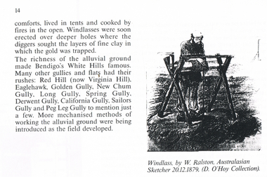
... Hustler's Line of Reef Bell and Irons Ballerstedt and Son Young ...12 photocopied pages. Page four has acknowledgements, Page five mentions Pen-Portraist by Raly Wallace and Kevin Vallence, Page 14 mentions some rich areas: White Hills, Red Hill (now Virginia Hill), Eaglehawk, Golden Gully, New Chum Gully, Long Gully, Spring Gully, Derwent Gully, California Gully, Sailors Gully and Peg Leg Gully. There are two sketches on the page: Windless, by W. Ralston, Australasian Sketcher 20/12/1879 (D O'Hoy Collection) and a sketch of some miners in a tent with some mining equipment in front of it. There are two men in front of a fire at the front of the tent. Page 16 has a sketch of an old brick house with iron lace on the veranda and a picket fence at the front. Page 17 mentions the school and some Friendly Societies and Church. Page 22 mentions Quartz Mining. There is a Lithograph of a Quartz outcrop, New Chum Gully 1852 by George Rowe and a View of Surface Workings 1861, a Batchelder Photo. Page 23 mentions Edward Nucella Emmett, a pioneer gold digger who became involved in many important public issues. Page 25 mentions Company Mining and Crushing. It has a sketch of a Primitive Quart Crusher. Page 37 Mentions Richard Pope, a Miner who tramped from job to job in Bendigo and eventually followed the rush to Broken Hill. Page 38 mentions the Eaglehawk Brass Band and Friendly Societies in Eaglehawk. Page 39 is headed Miner's Cottage. It mentions stone miners' cottages. Page 40 has a sketch of a Georgian Style Sandstone Cottage Harvey Town. Page 41 mentions men sweeping the road to get gold, Bull Family grocery shop and a blacksmith. Page 42 is headed St. Augustine's. Page 43 has a sketch of St. Augustine's Church. Page 59 is headed Bendigo Amalgamated Goldfields (B.A.G.) Edward Clarence Dyason was largely behind a new company set up in 1917 to work the Bendigo field in an entirely new way. (B.A.G.) wished to take over all existing mining companies, and place them under a single management structure.bendigo, history, long gully history group, the long gully history group - some historical information, mr l hooley, mr l bennetts, mr w watson, mr w heraud, mr d m davies, mr w perry, mr h harvey, mr a llewellyn, mr e oates, chook temple by mr alan llewellyn, mr f cusack, tracey ipsen, ray wallace, bendigo field naturalists' club, eaglehawk tree lovers' society, bendigo historical society, university of melbourne, kevin vallence, monash university, bendigo technical college, south australian writer's fellowship, windlass, w ralston, australasian sketcher 20.12.1879, d o'hoy, mechanics institute, california gully school, bell topper hill, i.o.r. (rechabites), cobden tent, refuge tent, sutton tent, m.u.i.o.o.f.'s loyal darling, bible christian church, california hill wesleyan methodist church, saint jude's anglican church, quartz mining, e n emmett, jonathan harris, haris' claim, j hustler, george rowe, batchelder, la trobe library, cave, amos, new chum line of reef, edward nucella emmett, bendigo city council, all saints, william westgarth, latham and watson, hustler's line of reef, bell and irons, ballerstedt and son, young and company, nicholas and bassit, ensor, thomas carpenter, quartz crusher, goldfields and mineral districts of victoria, richard pope, daniel webster mine, isaac dyason, old chum mine, north old chum mine, young chum mine, george lansell, lazarus, silicosis of the lungs, eaglehawk brass band, victoria hotel, mr williams, eaglehawk branch of the australian natives association, loyal catherine lodge, mr james, odd fellows in the loyal catherine lodge branch no 4935, richard harvey, thomas harvey, moonta copper mines, harvey town, national trust of australia, eaglehawk tree lovers society, saint mungo's methodist church, clark's beehive battery, world war 1, kee-young, lady barkly hotel, prankhurst, bull family, cousin jack, st augustine's, myers, nicholls, john o'brien, around the boree log, the rev dean hayes, st kilian's, bendigo amalgamated goldfields (b.a.g.), edward clarence dyason, r h s abbott, hercules and energetic, south new moon, new chum goldfields, central red white and blue consolidated, brown john, the life and times of long gully, bendigo press, val white, megan snoop -
Bendigo Historical Society Inc.
Document - MINING REPORTS - BENDIGO GOLDFIELD PRODUCTION
Handwritten notes detailing tons of ore and ounces of gold it produced for mines on the Hustlers, Paddy's Gully, Garden Gully, Deborah, Sheepshead, New Chum, Nell Gwynne, Napoleon, Lancashire, Thistle and Christmas Lines of Reef. Also the Napoleon Syncline and Mary McDonald Spurs. Also mentioned is the average per ton.document, gold, mining reports, mining reports, bendigo goldfield production, m d, q r & a r, bendigo advertiser, b m l, burrell's records -
Bendigo Historical Society Inc.
Document - MINING IN BENDIGO COLLECTION: NOTES ON MINING IN BENDIGO
Handwritten notes on mining in Bendigo. Notes mention the size of the Bendigo Goldfield, the number of lines of reef and a brief history of goldmining in Bendigo.document, gold, mining in bendigo, mining in bendigo, notes on mining in bendigo, ravenswood sheep run, survey regiment, california hill state school, lansell's 222, mr lansell, camp hill school, high school, park mine (royal hustler's reserve no 1), memorial hall, city mine ( royal hustlers reserve no 2), mining stock exchange, beehive buildings, allan's walk, buckell & jeffrey, fortuna hustlers, great extended huatlers, garden gully united, mining exchange, garden gully united, wattle gully mine, ironbark mine, manchester arms hotel, extended hustlers mine, south belle vue, new chum railway, eureka extended, shenandoah, victoria quartz, the big 180, old chum, gt extended hustlers -
Bendigo Historical Society Inc.
Document - BOOKLET NOTES - SADDLE REEFS AND SPURS
Handwritten notes titled 'Saddle Reefs and Spurs'. The notes were written to replace 'The Reefs' in a previous booklet. Notes describe saddle reefs and spurs, the different terminology relating to them, why some reefs were richer than others, where the shaft was positioned relating to the reef and the description of spurs and where they occur.document, gold, booklet notes, mining, booklet notes, saddle reefs and spurs, j n macartney, bendigo goldfield registry 1870, collman, lancashire line, nell gwynne line, new chum line, sheepshead line, garden gully line, collman and tacchi, great extended hustlers, a r -
Bendigo Historical Society Inc.
Document - MINING REPORTS - LIST OF GOLD MINES OR MINING COMPANIES
Handwritten list of Gold Mines or Mining Companies. Listed are: Australian United Quartz Co Sandhurst, Advance Co, Big Hill Tribute Co, Birds Reef Railway Reserve Mine Co, British Banner Gold M Co, Brookfield Gold M Co, Carlisle North Garden Gully, Caroline Gold M Co, Central Garden Gully, Charles Gavin Duff Gold M Co, Charleston Quartz, Cinderella Co, Collman Tacchi & Nelson, Confidnece Gold M Co, Cornish United Gold M Co, Derby Gold Mine Co, Dixon's Tribute Co, Ellesmere black Lead Tribute Co 1871, Empire Amalgamated, Extended Gold M Co (Majorca), Extended Co Victoria Reef, First Chance Tribute, Fortuna, Golden Fleece & Heales United, Garden Gully United, Garden Gully, Golden Fleece, Golden Point, Golden Lion Tribute Garden Gully Reef, Great Golden Fleece Co, Great Wonder Co, Gilmons Golden Palm Trib Co, Golden Garden Gully Co 1873, Golden Sovereign Extended Trib Co 1872, Great Extended Garden Gully Co 1874, Great Extended South Hustlers Co 1872, Great Republic Corp, Ironbark Co, Kangaroo Flat Steam Puddling & Qaurtz M Co, Riverpool Gold M Co, Iron Duke Co 1871, Henry Van Der Hugen Pioneer G M Co, Kent M Co, Kentish Co, Mariners Reef Co, Mary Hill Trib Co, Morning Star Gold Mine Co, Mount Korong Lane's Reef M Co, New Chum & Victoria Trib Co, New Hopeful Gold M C, New Homeward Bound, New Lord Warden Trib Co, North Lord Warden Trib Co, North Nelson, North Golden Pyke Co, North Old Chum, North Shamrock, North Birds Reef Co, North Birds Tribute Co, New Chum Freehold, New Era, No 3 Wilson's G M C, Odin Reef Co, Oriental Perserverance G M C, Paddy's Reef Trib Co, Palm Gold M Co, Palm Tribute Co, Pearl Tribute Co, Pegleg Gully Quartz G M C, Pegleg Quartz M C, Princess Dagmar G M C, Prince of Wales Amalgamated (Tarnagulla), Pyrances Gold M C, Passby United G M C, Quartz Hill Quartz M C, Pevieres Victory Trib Co, Royal Oak Quartz, Royal Standard Trib Co, Royal George Quartz G M C, Royal Golden Fleece, Sable Chief G M C, Sainia Reef Quartz M Co, South Fraser Reef G M C, Southern New Chum Gold M C, Shanandoor Tribute, Sebastian Gold M Co, Sophia & Redan G M Co, Youth Bell Vue Co, Shannon Company, South Extended Wallaby Co, South Ramrod Co, South Royal Hustlers Co, South Wallaby Trib Co, United Hustlers, United Hustlers & Redan Co, United Bros Tribute Co (Myrtle Creek), United Gold Mine Co, Victoria Reef Gold M Co, Victorian Consolidated M Co, Victoria Reef Quartz, Virginia Gold M Co, Victory and Pandora, Young Chum, South Homeward Bound Co, South Shilling Co, South Nuggetty Co, South Devonshire Co,South Keep it Dark, Try Again Tribute Co Victoria Hill.document, gold, mining reports, mining reports, list of gold mines or mining companies, australian united quartz co sandhurst, advance co, big hill tribute co, birds reef railway reserve mine co, british banner gold m co, brookfield gold m co, carlisle north garden gully, caroline gold m co, central garden gully, charles gavin duff gold m co, charleston quartz, cinderella co, collman tacchi & nelson, confidnece gold m co, cornish united gold m co, derby gold mine co, dixon's tribute co, ellesmere black lead tribute co1871, empire amated, extended gold m co (majorca), extended co victoria reef, first chance tribute, fortuna, golden fleece & heales united, garden gully united, garden gully, golden fleece, golden point, golden lion tribute garden gully reef, great golden fleece co, great wonder co, gilmons golden palm trib co, golden garden gully co 1873, golden sovereign extended trib co 1872, great extended garden gully co 1874, great extended garden gully co 1874, great extended south hustlers co 1872, great republic corp, ironbark co, kangaroo flat steam puddling & qaurtz m co, riverpool gold m co, iron duke co 1871, henry van der hugen pioneer g m co, kent m co, kentish co, mariners reef co, mary hill trib co, morning star gold mine co, mount korong lane's reef m co, new chum & victoria trib co, new hopeful gold m c, new homeward bound, new lord warden trib co, north lord warden trib co, north nelson, north golden pyke co, north old chum, north shamrock, north birds reef co, north birds tribute co, new chum freehold, new era, no 3 wilson's g m c, odin reef co, oriental perserverance g m c, paddy's reef trib co, palm gold m co, palm tribute co, pearl tribute co, pegleg gully quartz g m c, pegleg quartz m c, princess dagmar g m c, prince of wales amalgamated (tarnagulla), pyrances gold m c, passby united g m c, quartz hill quartz m c, pevieres victory trib co, royal oak quartz, royal standard trib co, royal george quartz g m c, royal golden fleece, sable chief g m c, sainia reef quartz m co, south fraser reef g m c, southern new chum gold m c, shanandoor tribute, sebastian gold m co, sophia & redan g m co, youth bell vue co, shannon company, south extended wallaby co, south ramrod co, south royal hustlers co, south wallaby trib co, united hustlers, united hustlers & redan co, united bros tribute co (myrtle creek), united gold mine co, victoria reef gold m co, victorian consolidated m co, victoria reef quartz, virginia gold m co, victory and pandora, young chum, south homeward bound co, south shilling co, south nuggetty co, south devonshire co, south keep it dark, try again tribute co victoria hill. -
Bendigo Historical Society Inc.
Document - MINING IN BENDIGO COLLECTION: NOTES ON MINES
Handwritten notes on Bendigo Mines. Notes include the number of ounces of gold obtained up to 1954 when the mines closed, total dividends paid, average production per ton, number of shafts The Mines Dept, made safe, notes on the South New Moon, Garden Gully United, New Chum Goldfields and the Catherine Reef United.document, gold, mining in bendigo, mining in bendigo, notes on mines, carlisle, central blue, central nell gwynne, fortuna hustlers, garden gully united, lady barkly, new argus, new red white & blue consol, south new moon, mines dep't, garden gully united, healthy golden bendigo, south new moon, roberts & sons, new chum goldfields, catherine reef united -
Bendigo Historical Society Inc.
Document - MINING REPORTS - LEADING AND PROMINENT MINES
Handwritten notes with the first page relating to typing of the notes. Next three pages relate to leading and prominence of mines - the United Devonshire, formed 1873; the Victoria (Reef) Quartz formed 1878, start 1870 as Victoria Reef; and the Hercules & Energetic.document, gold, mining reports, mining reports, leading and prominent mines, miss parry, carlisle united, fortuna hustlers, gt extended hustlers, mines dep't, central blue, lady barkly, new argus, new moon, new blue consolidated, south new moon, mr e jackman, united devonshire, victoria (reef) quartz, victoria reef, annals, mr wood, hercules & energetic, hercules, b a g -
Bendigo Historical Society Inc.
Document - ALBERT RICHARDSON COLLECTION: FORTUNA HUSTLERS MINE
Two page document with location map. The Fortuna Hustlers Gold mine was located close to the railway goods shed (Discovery Centre location) in an area occupied by Buckell and Jeffrey's office and yards. (now carpark of Marketplace shopping centre). It commenced operation in August 1888 and closed in December 1913.The depth of the shaft was 2,240ft. Features of the plant described are: the winding engine, the air compressor, boilers, baling tanks, poppet legs, engine house. The winding engine later worked at the Tambour Major at Specimen Hill; Birds Reef at Kangaroo Flat, Hercules No. 1 on top of Danger Hill and the North Virginia mine at Eaglehawk.bendigo, mining, fortuna hustlers mine -
 Bendigo Historical Society Inc.
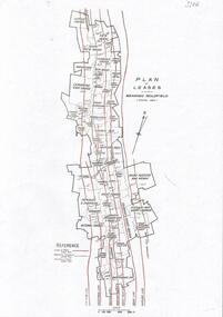
Document - BENDIGO GOLD MINING PLAN OF LEASES, CENTRAL AREA
One page document with a diagram showing reef lines and lease holdings in the central area of the Bendigo Goldfield. Reef lines shown are Sheepshead Line, Deborah Line, Garden Gully Line, Paddy's Gully Line, Hustlers Line. Sourced from Bendigo Goldfields Library, Central area. CD Rom 622.3422 BENbendigo, mining, lease holdings and reef lines -
 Bendigo Historical Society Inc.
Document - ALBERT RICHARDSON COLLECTION DEEP MINES ON THE BENDIGO FIELD
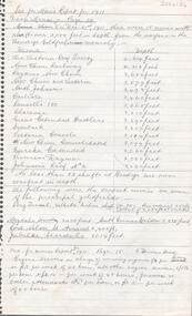
One page document titled ' Secretary for Mine's Report for 1911, Deep Mines page 24. List of mines and depths, The Victoria Quartz 4614 feet, New Chum Railway 4318 feet, Lazarus New Chum 3682 feet, New Chum and Victoria 3579 feet, North Johnson's 3498 feet, Carlisle 3460 feet, Lansell's 180 3365 feet, Clarence 3310 feet, Great Extended Hustlers 3290 feet, Ironbark 3250 feet, Victoria Consols 3114 feet, New Chum Consolidated 3099 feet, Eureka Extended3060 feet, Princess Dagmar 3020 feet, Johnsons Reef No 2 2020 feet.bendigo, mining, deep mines on the field -
Bendigo Historical Society Inc.
Document - MINING WARDEN COLLECTION:BENDIGO HISTORICAL MINING RECORDS
... . Mines along the following reef lines are described: Hustlers.... A summary document lists the mine name; the Ben #; the line of reef ...Historical records originally from the Mining Warden's Office, Mines Department, Bendigo. A summary document lists the mine name; the Ben #; the line of reef located on, the start and end year. Information collated from 1870's to 1980's. Each mine's data is enclosed in a manilla folder within the box. Mines along the following reef lines are described: Hustlers Millers Derby Paddy's Gully Ben # range from 2275 to 2584 Example of entry: Sydney Garden Gully Quartz Mining Co., Ben # 2371, Millers Reef, 1872 - 1875.bendigo, mining, mining warden's records