Showing 124 items
matching l jackson
-
 Bendigo Historical Society Inc.
Map - GUIDE MAP OF BENDIGO & EAGLEHAWK, Late 1920's
Map. Guide map of Bendigo & Eaglehawk. Folded map of Bendigo & Eaglehawk with blue outer cover booklet. Map is compiled by E E Parker, Eaglehawk. Map shows tramways, bus routes and cost one shilling. Map shows Agricultural Showgrounds located between Park Street, Water Street, Barnard Street and Bridge Lane. Also shows Acclimitization Reserve located behind the Botanical Gardens at White Hills. Shows the location of Sailors Gully, Peg-Leg Gully, Jobs Gully, California Gully, Long Gully, Ironbark Gully, Golden Gully, Poverty Gully, Sheepshead Gully, Charcoal Gully, Eaglehawk Creek, Bendigo Creek and Back Creek.Contains interesting facts about Bendigo:- Area - 7,900 acres, Population - 26,000, First Council elected - 1855, Proclaimed a City - 1871. Gold Rush broke out - 1851. For first 10 years gold yield averaged 8,600 ozs. Per week. Total gold yield to 1923 - 572 tons valued at 82,000,000 pounds. Deepest mines - Victoria Quartz 4,614 ft., New Chum Railway 4,318 ft., 13 mines over 3,000ft. deep, 53 mines over 2,000 ft. deep. Sewering of City commenced 1922. All principal buildings now sewered. Map printed by Arnall & Jackson, General Printers, Stationers & Engravers, 476 Collins Street. Outer map blue cover printed in red and blue ink by J B Young, Lithographer. Map displays advertisement for Bendigo Timber Co. Outer blue cover displays advertisement for Campbell Connelly & Co. Pty. Ltd, Ironmongers, Timware Manufacturers, Plumbers, Sewerage Contractors, High and Forest Sts, Bendigo 9outside back cover) and for Hartleys ( J L Shoosmith) Bendigo, displaying Indian Motor Cycles (inside back cover).map, bendigo, township, guide map of bendigo & eaglehawk -
 Bendigo Historical Society Inc.
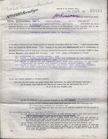
Document - MCCOLL, RANKIN AND STANISTREET COLLECTION: DEBORAH EXTENDED GMC N L - GOLD MINING LEASE, 21/9/1940
Document. Lease No 11080 Bendigo dated 21/9/1940. Entered in the Register book Vol. 325 Fol 35847 to Herbert Jackson Leed of Bendigo.McColl, Rankin & Stanistreetorganization, business, deborah extended mine, mccoll, rankin & stanistreet, deborah extended gmc n l, h j leed, gold mining, lease -
 Bendigo Historical Society Inc.
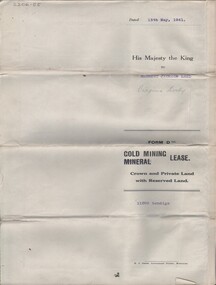
Document - MCCOLL, RANKIN AND STANISTREET COLLECTION: NORTH VIRGINIA GMC N L - TITLE DEED, 13/5/1941
Document. Coarse cream coloured paper, typed corrections and additions. Assistant Registrar of Titles. Made out to Herbert Jackson Leed of Bendigo.McColl, Rankin & Stanistreetorganization, business, north virginia gmc n l, mccoll, rankin & stanistreet, north virginia gmc n l, h j leed, gold mining, title deed -
 Bendigo Historical Society Inc.
Document - NORTH OLD CHUM MINE - NOTES ON THE NORTH OLD CHUM MINE
Handwritten notes on the North Old Chum Mine. Notes include depth of shaft Years, Dividends, tons, ounces of gold, authority and remarks.Note: Lansell's 180 Co absorbed this lease in 1900. Names include: Early Workings, Wybrant (John), Wybrant's Trib, North Old Chum, Jackson's Claim, Jackson's Trib, South Victoria Co?,document, gold, north old chum mine, north old chum mine, notes on the north old chum mine, wybrant (john), wybrant's trib, north old chum, jackson's claim, jackson's trib, south victoria co?, lansell's 180 co, production statistics bendigo m l page 110, mines dept.