Showing 419 items
matching localities
-
 Bendigo Historical Society Inc.
Document - CENTRAL RED, WHITE AND BLUE MINE - LOCALITY AND DESCRIPTION OF THE CENTRAL RED, WHITE AND BLUE MINE
Hand written notes on the Central Red, White and Blue Mine. Notes include depth of Shaft, when formed, locality, plant, poppet legs, engine house, crushing battery, gold produced and the reef the gold was obtained from. Also includes references.mine, gold, central red, white and blue mine, central red, white and blue mine, locality and description of the central red. white and blue mine, sheepshead line of reef, new chum hill, delbridge or mannings shaft, mine's dep't booklet 'bendigo goldfield' geo brown 1936, annals of bendigo1910 to 1936, a richardson -
Port Melbourne Historical & Preservation Society
Book, Sandridge Municipality Assesment Book, 1862
Municipal District of Sandridge Assessment (Rates;Valuations) Book for 1862 to 1863. Details of occupiers, owners, description and locality as well as values and rates included. Certification date October 13, 1862. Ledger with marbled card cover with red gold-embossed label.local government - municipal district of sandridge -
Clunes Museum
Book, DEPARTMENT OF LANDS AND SURVEY, LICENCE
RECEIPTS ISSUED TO CUSTOMER DENOTING LOCALITY TO SPLIT AND TAKE AWAY EUCALYPTUS TIMBER FROM BUSH. LICENCES ISSUED PER QUARTER.BLUE CARDBOARD COVERED BOOK CONTAINING TIMBER LICENSE FOR ORDINARY WOOD ISSUED SEPTEMBER 1884 TO OCTOBER 1892. RECEIPT NUMBERS 124121 - 124130ON FRONT COVER: TIMBER LICENSE ORDINARY WOOD 50/- NO.1 EXHAUSED AFTER AUDIT 23-8-92local history, book, licence, receipt, timber licence -
 Victorian Aboriginal Corporation for Languages
Book, Bibliography of the Victorian Aborigines : from the earliest manuscripts to 31 December 1970, 1971
This bibliography is designed to list all the material written about Victorian Aborigines (except for newspaper accounts) within the given time frame. The material has been divided under headings distinguishing the subject, town, region and locality in alphabetical order, and provide a cross-index.colour illustrationshistorical bibliography, victorian aborigines, victorian history, local history -
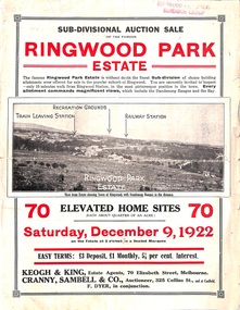 Ringwood and District Historical Society
Flyer, Sub-divisional auction sale advertisement - Ringwood Park Estate, Ringwood, Vic. - 1922
Folded double-sided page with black and white photographs of local views with black and red print advertising auction sale on Saturday 9th December, 1922, - 70 residential home sites, including terms of sale, locality map, and description of local facilities and services. Subdivision includes Wonga Road (later Loughnan Road), William Street, Andrew Street, and Harrison Street. Vendors Solicitors - Rigby & Fielding, 60 Market Street, Melbourne. Estate Agents - Keogh & King, 70 Elizabeth Street, Melbourne, Telephone 6938. Auctioneer - Cranny, Sambell & Co., 325 Collins Street, Melbourne, Telephone Central 5067 and 5077. -
 Bendigo Historical Society Inc.
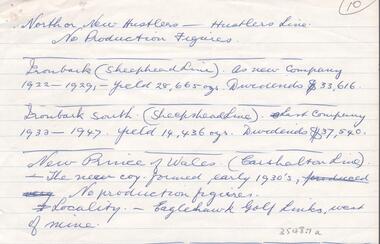
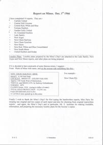
Document - GOLD PRODUCTION - NOTES ON GOLD PRODUCTION
Handwritten notes by Albert Richardson on gold production, year and dividends of North or New Hustlers (Hustlers Line), Ironbark (Sheepshead Line), Ironbark South (Sheepshead Line), New Prince of Wales (Carshalton Line). And locality of the New Prince of Wales. Albert Richardson CollectionAlbert Richardsongold, goldfields, victoria, gold production, notes on gold production, north or new hustlers, hustlers line, ironbark, sheepshead line, ironbark south, new prince of wales, carshalton line, eaglehawk golf links -
 The Beechworth Burke Museum
Geological specimen - Brown Coal
Brown Coal is typically found as rocks. During formation the Brown Coal starts as peats, which is an acidic brown deposit resembling soil, and over time when subjected to pressure and heat these peats form the Coal. Brown Coal is the lowest rank of coal as it has a low carbon (energy) content, and a high moisture content. This high moisture content makes Brown Coal unsuitable for overseas exports. This particular specimen was recovered from the Yallourn Mine in Latrobe Valley, Victoria as part of the geological survey of Victoria being carried out by Alfred Selwyn. Otherwise known as the 'Yallourn Power Station', the Yallourn Mine is Australia's second largest mine. Yallourn Mine was first built in 1920, and since then it has been providing over 1 billion tonnes of Brown Coal to Australia every year. The Yallourn Mine is responsible for 22% of Victoria's electricity and 8% of Australia's electricity. As of 2021 the mine employs around 500 people. Due to ongoing maintenance issues and Australia's move to cleaner energy, the Yallourn Mine intends to shut down permanently as of 2028. Soon after gold was discovered in 1851, Victoria’s Governor La Trobe wrote to the Colonial Office in London, urging ‘the propriety of selecting and appointing as Mineral Surveyor for this Colony a gentleman possessed of the requisite qualifications and acquaintance with geological science and phenomena’. Alfred Selwyn was appointed geological surveyor in Australia in 1852 which began the Geological Survey of Victoria. In 1853-69 the Geological Survey issued under Selwyn's direction sixty-one geological maps and numerous reports; they were of such high standard that a writer in the Quarterly Journal of the Geological Society of London bracketed the survey with that of the United States of America as the best in the world. During his years spent in Australia, Selwyn collected numerous significant geological specimens, examples of which are held in collections such as the Burke Museum.Brown coal is considered to be an essential rock to Australia's energy consumption. Although plentiful in sources, Brown Coal is not able to be exported overseas due to its high moisture content. As Australia moves towards cleaner energy, Brown Coal is going become less used. This specimen is part of a larger collection of geological and mineral specimens collected from around Australia (and some parts of the world) and donated to the Burke Museum between 1868-1880. A large percentage of these specimens were collected in Victoria as part of the Geological Survey of Victoria that begun in 1852 (in response to the Gold Rush) to study and map the geology of Victoria. Collecting geological specimens was an important part of mapping and understanding the scientific makeup of the earth. Many of these specimens were sent to research and collecting organisations across Australia, including the Burke Museum, to educate and encourage further study.A solid hand-sized sedimentary rock that is a dark shade of brown.13 / BROWN COAL / Showing Woody structure / Locality: Yallourn, Vic. | Label probably / correct but / can't find reference / no. 13 to match in / registers. / C Willman / 15/4/21burke museum, beechworth, indigo shire, beechworth museum, geological, geological specimen, mineralogy, yallourn, yallourn mine, victoria, coal, brown coal, brown coal specimen, alfred selwyn, geological survey of victoria, geological survey, yallourn power station -
Creswick Campus Historical Collection - University of Melbourne
Book, James A. McKinty, 1936
This is a catalogue of the shells contained in the cabinet in the University Building foyer. Also a classification of the Mollusca and notes on various species and the locality from which collected.Catalogue of shells -
 Bendigo Historical Society Inc.
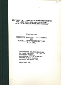
Book - HISTORY OF COMMUNITY HEALTH NURSING, RESEARCH PAPER, 1993
History of Community Health Nursing for a Low Socio-economic Group in a Locality of Unique Australian History. Submission for The First national Conference on Austrlain Nursing History May, 1993. Prepared by diane M. Francis La Trobe University College of Northern Victoria , February 1993Diane M. Francis.australia, history, community health nursing. -
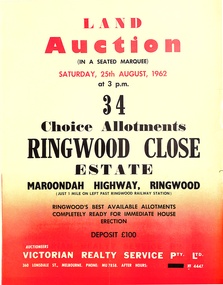 Ringwood and District Historical Society
Pamphlet, Land Auction Brochure - Ringwood Close Estate, Ringwood, Victoria - 1962
Brochure advertising public auction of 34 allotments on Saturday 25th August, 1962. Brochure includes terms of sale, description of subdivision features and local facilities, with locality map. Subdivision includes Anthony Court, Nina Court and Wingrove Place, off Maroondah Highway, Ringwood.Auctioneer - Lindsay Lord, Victorian Realty Service Pty Ltd., 360 Lonsdale Street, Melbourne. Phone MU7858, After hours XF4447. Map includes handwritten pricing notations for some allotments. -
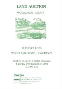 Ringwood and District Historical Society
Pamphlet - Land Sales Brochure, Woodlands Estate, Heathmont, 1985
Bifold pamphlet with picture on front, one inside plus plan of Woodlands Road sub division and locality plan on back page. All in green print. Copy enclosed with handwritten sale prices. Auctioneer's notes (Richard Carter) indicate vendor - Estate of Phoebe Beard.Auction on site in a seated marquee, Saturday 14th December, 1985. Agent - C.E. Carter & Son Pty. Ltd., 122 Whitehorse Road, Ringwood, 3134. Telephone 870 6211. -
 Bendigo Historical Society Inc.
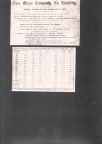
Document - NEW MOON COMPANY, NO LIABILITY - NOTES AND TABLE OF THE NEW MOON COMPANY, NO LIABILITY
Printed notes and table on the New Moon Company, No Liability on photographic type paper. Notes include: capital, mining lease,battery machine lease, locality, registration and machinery. The second page is a table of the gross total of tons, gold, dividends and calls to June 30th, 1906.photo, new moon company, no liability, notes and table of the new moon company, no liability -
 Bacchus Marsh & District Historical Society
Map, Gorrockburkchap Parish Map, County of Grant c.1906
The parish of Gorrockburkchap (sometimes spelled Gorrockburkghap) lies to the west and south west of the township of Bacchus Marsh. The locality of Rowsley is situated within this parish area.A single page paper map showing the parish plan for Gorrockburkchap in the County of Grant. A cadastral map showing parish boundaries and land ownership The map is pasted into a bound volume containing 76 maps or plans in total. High resolution digital image stored on BMDHS computer network. gorrockburkchap parish maps, rowsley victoria maps, bacchus marsh region parish plans -
 Bacchus Marsh & District Historical Society
Map, Gorrockburkchap Parish Map, County of Grant c.1915
The parish of Gorrockburkchap (sometimes spelled Gorrockburkghap) lies to the west and south west of the township of Bacchus Marsh. The locality of Rowsley is situated within this parish area.A single page paper map showing the parish plan for Gorrockburkchap in the County of Grant. The map is pasted into a bound volume containing 76 maps or plans in total. High resolution digital image stored on BMDHS computer network. gorrockburkchap parish maps, rowsley victoria maps -
 Bacchus Marsh & District Historical Society
Map, Gorrockburkchap Parish Map, County of Grant
The parish of Gorrockburkchap (sometimes spelled Gorrockburkghap) lies to the west and south west of the township of Bacchus Marsh. The locality of Rowsley is situated within this parish area.A single page paper map showing the parish plan for Gorrockburkchap in the County of Grant. The map is pasted into a bound volume containing 76 maps or plans in total. High resolution digital image stored on BMDHS computer network. gorrockburkchap parish maps, rowsley victoria maps -
Bendigo Historical Society Inc.
Map - CAMPBELL COLLECTION: BENDIGO & DISTRICT MAPS, 21-8-1972
Map. Strathfieldsaye. Locality Plan, Scale 1 inch, also marked are : Shire of Huntly, Shire of McIvor, Shire of Metcalfe, Shire of Maldon, Shire of Marong, City of Bendigo, Lake Eppalock, and various lanes and roads. Mileage on some roads. (number 370 in map cupboard 1)M.Higgsmap, bendigo, rural -
 Melbourne Tram Museum
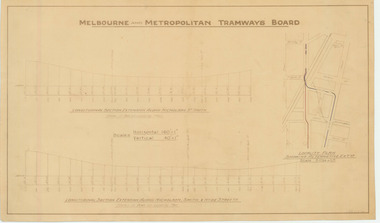
Drawing, Melbourne & Metropolitan Tramways Board (MMTB), "Nicholson St Footscray - alterations for extensions south", Dec. 1947
Drawing - not formally titled - "Nicholson St Footscray - alterations for extensions south" Shows Longitudinal sections for extension along Nicholson St and alternatively Nicholson, Smith and Hyde Streets. Has a small locality plan on the right side showing the extensions in blue and red ink. undated and not numbered,On left hand edge on the rear has in pencil - "Nicholson St Footscray - alterations for extensions south" in blue pencil and marked in ink "Spare(Dup)"trams, tramways, footscray, nicholson st, new tramway, proposals, hyde st -
 Bendigo Historical Society Inc.
Document - MINING REPORTS - REPORT ON MINES DEC. 1ST 1966
Handwritten notes, with typed copy, listing 14 reports on mines and locality plans. If it was decided to have postcards of some famous mines, there is a suggestion of how they could be set out. Also a paragraph thanking the Mine's Dep't, Miss Parry and Mr. E. Jackman for work they have done.document, gold, mining reports, mining reports, report on mines dec 1st 1966, carlisle united, central nell gwynne, central red white and blue, fortuna hustlers, garden gully united, gt extended hustlers, lady barkly, new argus, new chum railway, new chum syncline, new moon, new red white and blue consolidated, south new moon, united hustlers and redan, mine's dep't, miss parry, mr e jackman -
 Wodonga & District Historical Society Inc
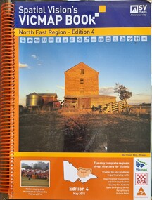
Book - Spatial Vision's VICMAP BOOK 2014 - North East Region
This edition of Spatial Vision's VicMap Book North East Region was published in May 2014 and provides detailed topographic maps for the region. It was used by emergency services and various agencies, including the Country Fire Authority (CFA). It covers areas including Wodonga, Albury, Wangaratta, and beyond, including national parks and recreation areas. Text on the cover states that the volume is "Trusted by and produced in partnership with: Department of Environment, Land, Water & Planning, Country Fire Authority, State Emergency Service, Parks Victoria, Victoria Police".A spiral bound volume of 409 pages including colour topographic maps and illustrations of North East Victoria. The cover features a colour photo of the old flour mill at Milawa, Victoria. It also features an index map inside the front cover, a legend, road index, and locality index.non-fictionThis edition of Spatial Vision's VicMap Book North East Region was published in May 2014 and provides detailed topographic maps for the region. It was used by emergency services and various agencies, including the Country Fire Authority (CFA). It covers areas including Wodonga, Albury, Wangaratta, and beyond, including national parks and recreation areas. Text on the cover states that the volume is "Trusted by and produced in partnership with: Department of Environment, Land, Water & Planning, Country Fire Authority, State Emergency Service, Parks Victoria, Victoria Police".emergency management north east victoria, cfa wodonga -
 Orbost & District Historical Society
map/brochure, Discovering Marlo & The Snowy River Estuary, December 1988
In 1983 the Department of Conservation, Forests and Lands replaced the Department of Crown Lands and Survey, the Department of State Forests and the Ministry for Conservation. This brochure/map was used as tourist information in Orbost.This item is a useful research tool.A folded map/brochure titled "DISCOVERING MARLO & THE SNOWY RIVER ESTUARY". On the front is a photograph of Marlo and the title in yellow print. There is a locality map for access to Corringle beach and the brochure Includes a key to fishing sites and various tourist locations. On the back of the brochure are notes on fishing, wildlife and a boating guide, map brochure snowy-river marlo -
 Bendigo Historical Society Inc.
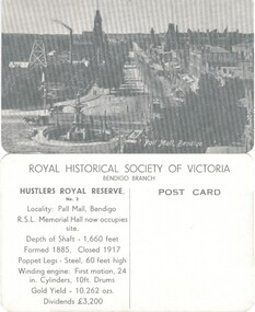
Photograph - HUSTLERS ROYAL RESERVE NO. 2 (POSTCARDS)
Hustlers Royal Reserve No. 2 (Postcards of the Royal Historical Society of Victoria - Bendigo Branch. 10 identical postcards showing mine and Pall Mall, Bendigo. On reverse: LH side with details of locality, shaft, poppet and engine details, gold yield and dividends. RH Side - blank for addresseeplace, mining site, hustlers royal reserve no 2 -
 Bendigo Historical Society Inc.
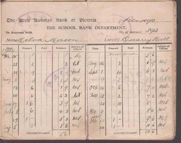
Document - W.D.MASON COLLECTION: PASSBOOK, 15 April 1929
Document/, W.D.Mason Collection, The State Savings Bank of Victoria, The School Bank Department. State School No. 1165, Quarry Hill, Name of Scholar is Melva Mason Locality Quarry Hill.Cream coloured, red tape-bound Savings Passbook - first entry dated 15.4.1929 with one penny deposit.business, retail, w d mason -
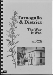 Bendigo Historical Society Inc.
Book - TARNAGULLA & DISTRICT - THE WAY IT WAS - EDNA AND KEN ARNOLD, 1992
BHS CollectionSoftcover spiral bound book with pale blue cover and black and white photograph of the Union Bank Tarnagulla and black printed Title. Contains 260 pages with an index, black and white photographs, tables and biographical entries for people who lived and worked in the Tarnagulla area and other nearby localities.Edna Arnold and Ken Arnoldbiography, tarnagulla, biographies, newbridge, laanecoorie, waanyarra, sandy creek -
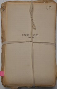 Bendigo Historical Society Inc.
Document - CROWN LAND TRACINGS, BENDIGO, 1890 - 1910
Document: Crown land tracings, dark buff coloured foolscap paper tied with white tape. On front ' Crown Lands tracings 1890 - 1910'. Contains applications for crown lands, City of Bendigo, 1890 - 1910 including list of allotments, names of persons, locality and tracings of land referred to.crown land tracings, bendigo, sandhurst, land sales, crown land -
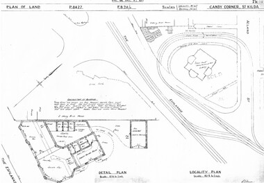 Melbourne Tram Museum
Drawing, Melbourne & Metropolitan Tramways Board (MMTB), "Candy Corner St Kilda", c1938
Set of two photocopied plans or drawings on A3 sheets of "Candy Corner St Kilda" .1 - P8427 - Plan showing locality plan, detail plan and adjacent buildings - 6-12-1938 .2 - ditto, but not the detail of the building in the centre of the island - "Green Knoll" Cafe and Amusement Park.trams, tramways, drawings, depots, property, candy corner, st kilda, turning loops -
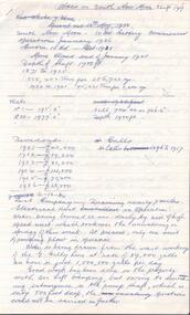 Bendigo Historical Society Inc.
Document - SOUTH NEW MOON MINE - NOTES ON THE SOUTH NEW MOON MINE
Four typed copies of notes on the South New Moon Mine on the Garden Gully Line of Reef. Notes include:- Years of operations, size of lease, locality, depth of shaft, plant, Original Company, New Company Note, Prominent & Leading and Gold Production. One copy signed by A Richardson.document, gold, south new moon mine, south new moon mine, notes on the south new moon mine, south virginia company, great southern mine, mines dept booklet 'bendigo goldfield' 1936, mines dept annual and quarterly reports, annals of bendigo mining section 1890 - 1935, a richardson, booklet 'healthy golden bendigo' 1906 - public library bendigo -
 Bendigo Historical Society Inc.
Document - LITTLE 180 MINE - NOTES ON THE LITTLE 180 MINE
Two handwritten and four typed copies of notes on the Little 180 Mine, Sheepshead line of reef. Notes include locality, depth size and sill of shaft, plant, Historical notes, best gold, gold yield and dividends and reference. Stapled, Typed copies not scanned. Albert Richardson Collectiondocument, gold, little 180 mine, little 180 mine, notes on the little 180 mine, lansell's little 180, sheepshead line of reef, john brown knitwear factory, a roberts & sons, s h johnson & co, deborah consolidated mine, big 180 mine, new chum syncline coy, george lansell, new chum line, central red white & blue, central blue, ironbark south mine, rae's hill, mines dept special edition australian mining standard 1/6/1899, mines dept booklet bendigo goldfield 1936, mines dept annual and quarterly reports, a richardson, catalogue mining sales j h curnow 19/4 1950 -
 Bendigo Historical Society Inc.
Document - LAZARUS MINE - NOTES ON THE LAZARUS MINE
Five pages of handwritten notes with typed copies of same, on the Lazarus Mine including Lazarus New Chum and Lazarus No 1. Notes include locality, depth of shafts, size of lease and plant. Includes the history, prominence, best gold, Total Gold Yield and Dividends. Albert Richardson Collectionmining, parish map, lazarus mine, lazarus mine, lazarus new chum, lazarus no 1, george lansell, b. c. v. 8 studios, sheepshead, central red white & blue, mr b lazarus, mr george gibbs, black lead, lansell's fortuna, mr ballerstedt, mr barnet lazarus, white lead, mines department special edition 'australian mining standard' 1/6/1899, mines department booklet 'bendigo goldfield' 1936, mines dept. annual and quarterly reports, annals of bendigo mining sections 1868 - 1910, a richardson, the bendigo goldfield registry j n macartney 1/3/1871. -
 Bendigo Military Museum
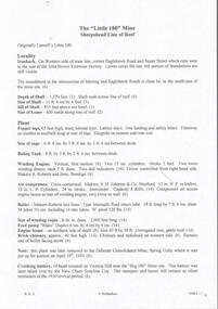
Document - ENEMY RAIDS ON AUSTRALIA, WW2, Post WW2
Information printed on chart: "Enemy Raids on Australia 19.02.42 to 12.11.43" The document lists in chart form the Enemy raids on Australia under the headings "Locality", "Date", "Results". "Locality" includes Darwin, Broome, Thursday Island, Wyndham, Horn Island, Derby WA, Katherine NT, Horn Island, Sydney, Newcastle, Townsville, Port Hedland, Mossman (90km north of Cairns), Milingimbi, Wessell Island, Exmouth Gulf, Fenton Aerodrome, Coomallie Fenton, Onslow, Drysdale Mission.Chart - white colour paper adhered to red coloured cardboard for display purposes. Facsimile copy with black ink print. Unknown source.document, chart facsimile, ww2, australia -
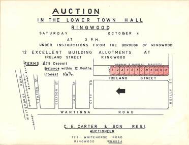 Ringwood and District Historical Society
Flyer, Building Allotments Auction Notice - Ireland Street, Ringwood, Victoria - circa 1960
Notice attached to light cardboard backing advertising auction in the lower town hall, Ringwood, at 3pm, Saturday October 4 (1958?) for 12 building allotments in Ireland Street, Ringwood. Locality plan with red shading highlighting sites for auction in Ireland Street under instructions from the Borough of Ringwood. (Agent) C.E. Carter & Son, 126 Whitehorse Road, Ringwood (Phone) WU 6024.