Showing 2592 items
matching maps of victoria
-
 St Kilda Historical Society
Photograph - Photo map, Department of Crown Lands and Survey, 22/01/1970
... with a current map, and access to other historical photo maps of Victoria... maps of Victoria, see the Historic Photo-Maps Index published ...One of a series of photo-maps produced for the Department of Crown Lands and Survey (1857-1983). For correlation with a current map, and access to other historical photo maps of Victoria, see the Historic Photo-Maps Index published by the Department of Environment, Land, Water and Planning at https://services.land.vic.gov.au/DELWPmaps/historical-photomaps/Black and white aerial photographCONTROLLED Vic 2358 Department of Crown Lands and Survey Victoria,.© Melbourne 1970 Project Run 41E 22.1.70 5,100 ASL 66st kilda, albert park, st kilda west, catani gardens, st kilda botanical gardens, st kilda pier, st kilda beach, 1970 -
 St Kilda Historical Society
Photograph - Photo map, Department of Crown Lands and Survey, 22/01/1970
... with a current map, and access to other historical photo maps of Victoria... maps of Victoria, see the Historic Photo-Maps Index published ...One of a series of photo-maps produced for the Department of Crown Lands and Survey (1857-1983). For correlation with a current map, and access to other historical photo maps of Victoria, see the Historic Photo-Maps Index published by the Department of Environment, Land, Water and Planning at https://services.land.vic.gov.au/DELWPmaps/historical-photomaps/Black and white aerial photographVic 2358 Department of Crown Lands and Survey Victoria,.© Melbourne 1970 Project Run 42E 22.1.70 5,100 ASL 75st kilda, st kilda beach, st kilda marina, point ormond, st kilda pier, 1970 -
 St Kilda Historical Society
Photograph - Photo map, 14/12/1963
... with a current map, and access to other historical photo maps of Victoria... maps of Victoria, see the Historic Photo-Maps Index published ...One of a series of photo-maps produced for the Department of Crown Lands and Survey (1857-1983). For correlation with a current map, and access to other historical photo maps of Victoria, see the Historic Photo-Maps Index published by the Department of Environment, Land, Water and Planning at https://services.land.vic.gov.au/DELWPmaps/historical-photomaps/Black and white aerial photographVic 1807 Melbourne 1963 Project Run 16 14.12.1963 Lens 205 152.70 M/M 5.150 177st kilda, st kilda pier, catani gardens, middle park, albert park, st kilda west, st kilda beach, 1963 -
 St Kilda Historical Society
Photograph - Photo map, Department of Crown Lands and Survey, 22/01/1970
... with a current map, and access to other historical photo maps of Victoria... maps of Victoria, see the Historic Photo-Maps Index published ...One of a series of photo-maps produced for the Department of Crown Lands and Survey (1857-1983). For correlation with a current map, and access to other historical photo maps of Victoria, see the Historic Photo-Maps Index published by the Department of Environment, Land, Water and Planning at https://services.land.vic.gov.au/DELWPmaps/historical-photomaps/Black and white aerial photographVic 2358 Department of Crown Lands and Survey Victoria,.© Melbourne 1970 Project Run 41E 22.1.70 5,100 ASL 64st kilda, st kilda cemetery, balaclava, st kilda east, windsor, caulfield north, alma park, 1970 -
 St Kilda Historical Society
Photograph - Photo map, Department of Crown Lands and Survey, 08/01/1970
... with a current map, and access to other historical photo maps of Victoria... maps of Victoria, see the Historic Photo-Maps Index published ...One of a series of photo-maps produced for the Department of Crown Lands and Survey (1857-1983). For correlation with a current map, and access to other historical photo maps of Victoria, see the Historic Photo-Maps Index published by the Department of Environment, Land, Water and Planning at https://services.land.vic.gov.au/DELWPmaps/historical-photomaps/Black and white arial photographVic 2345 Department of Crown Lands and Survey Victoria,.© Melbourne 1970 Project Run 40 8.1.70 5,100 ASL 77albert park, fawkner park, south yarra, middle park, prahran, windsor, st kilda, st kilda west, 1970 -
 St Kilda Historical Society
Photograph - Photo map, 22/01/1970
... with a current map, and access to other historical photo maps of Victoria... maps of Victoria, see the Historic Photo-Maps Index published ...One of a series of photo-maps produced for the Department of Crown Lands and Survey (1857-1983). For correlation with a current map, and access to other historical photo maps of Victoria, see the Historic Photo-Maps Index published by the Department of Environment, Land, Water and Planning at https://services.land.vic.gov.au/DELWPmaps/historical-photomaps/Black and white aerial photographVic 2358 Department of Crown Lands and Survey Victoria,.© Melbourne 1970 Project Run 43E 22.1.70 5,100 ASL 206elwood, elsternwick, elsternwick park, 1970 -
 Glenelg Shire Council Cultural Collection
Decorative object - Badge - Fish Holes Rally 1987, Portland, Victoria, c. 1987
... of Victoria, 'Portland' marked on map. 'FISH HOLES RALLY' around top... superimposed on outline map of Victoria, 'Portland' marked on map ...Fish Holes Rally badge, 1987. cream enamel and gold coloured badge. Image of motor bike superimposed on outline map of Victoria, 'Portland' marked on map. 'FISH HOLES RALLY' around top curve of badge. '1987' in gold frame bottom curve of badge. Eyelet each side of badge. -
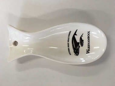 Warrnambool and District Historical Society Inc.
China, Spoon Rest, Early 21st century
... of a map of Victoria with a dot to show the location of Warrnambool.... of a map of Victoria with a dot to show the location of Warrnambool ...This spoon rest is a souvenir item for tourists to purchase. It is a souvenir of the presence of Southern Right whales at Logans Beach, a few kilometres from Warrnambool’s Central Business District. Each year Southern Right whales have been migrating from sub-Antarctic waters to the east coast of Australia during the winter months. Some whales have been coming each year from approximately May to October (since the 1980s) to have their calves at Logans Beach near Warrnambool. This area is now known as Warrnambool’s Southern Right Nursery. The whales calve about every three years and stay in the local waters along with other whales for about three months and over the past thirty years or so over 100 calves have been born at Logans Beach. The whales are now a winter tourist attraction (if an unpredictable one) as they can be viewed from a raised purpose-built platform area and they are often very close to the shore.This spoon rest is of interest as it is a souvenir of the Southern Right Whale Nursery at Logans Beach, Warrnambool and it has a practical use in the kitchen. It indicates the popularity of whale-viewing at Logans Beach and the importance of the presence of the whales, both scientifically and economically as the annual whale migration to our waters is now a vital aspect of tourism in Warrnambool. This is a Warrnambool souvenir cream-coloured china spoon rest in the shape of a whale or fish. It has a hole at the top for hanging the item on a hook and the printed material is in black and includes a sketch of a mother whale and calf. It has the distributor’s name on the back in yellow writing with an outline of a map of Victoria with a dot to show the location of Warrnambool.‘Southern Right Whale Nursery, Warrnambool’ ‘Lady Bay Creations, Warrnambool, Australia’ southern right whales, warrnambool’s southern right whale nursery, history of warrnambool -
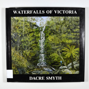 Marysville & District Historical Society
Book - Hardcover book, Dacre Smyth et al, Waterfalls of Victoria, 1988
... cover of book, both back and front have a map of Victoria... of book, both back and front have a map of Victoria with various ...A book of photographs of paintings of the waterfalls of Victoria painted by Dacre Smyth.A book of photographs of paintings of the waterfalls of Victoria painted by Dacre Smyth. Each painting has the name of the waterfall, the date the painting was painted and a short poem accompanying the photograph. Commodore Dacre Henry Deudraeth Smyth, AO was a senior officer in the Royal Australian Navy, an artist and a poet. He joined the RAN in 1940, and participated in the D-Day landings and the Battle of the Coral Sea before retiring as a commodore in 1978. He served as Deputy Chairman of the Trustees of Melbourne's Shrine of Remembrance and was a Life Governor of the Shrine. He became well known after his retirement for landscape and seascape painting, publishing fourteen books containing his paintings and poems. He married Jennifer Haggard in 1952, and had four daughters and a son. He died in 2008.Hardcover. Front dust cover has a photograph of a painting of Erskine Falls painted by the author. Back cover has 4 photographs of paintings of Wannon and Nigretta Falls in summer and winter. Inside cover of book, both back and front have a map of Victoria with various towns shown and the location of all the waterfalls in Victoria.Signature of the author and painter, Dacre Smyth. Artist's Acknowledgements / I am most grateful to all who helped in the production of this book:- / Alan Copeland / Allan Tuite and staff at Crystal Offset Printers for the production and printing of this book / Photography Ralph Petty / Colour Separations front & back cover Scanagraphix & Image Scan / Binding J.P. Bookbinderswaterfalls, victoria, melbourne, paintings, poem, poetry, photograph, dacre henry deudraeth smyth, royal australian navy, d-day landings, battle of the coral sea, shrine of remembrance, jennifer haggard -
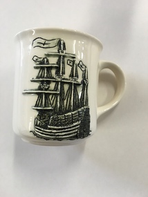 Warrnambool and District Historical Society Inc.
Mug, Mary Rose Ehibition, Late 20th century
... the distributor’s name on the bottom with a map of Victoria and a brown dot... the distributor’s name on the bottom with a map of Victoria and a brown dot ...This is a souvenir mug produced for visitors to the ‘Mary Rose’ Exhibition in Warrnambool (December 1994 to February 1995). The ship ‘Mary Rose’, built in Portsmouth, England in 1509-10, was historically of major significance. She was the spearhead of a master plan to give England superiority on the high seas. Using new technology of the time, heavy artillery was mounted on the lower decks of this ship and this overloaded the ship. In 1545 she sank in Portsmouth Harbour with the loss of 700 lives as she was about to set sail to defend the English against the French invaders. In 1982 the hull of this ship was raised to the surface and the contents recovered. Over 200 items from the wreck were brought to Warrnambool and displayed in 1994-5 at the Warrnambool Art Gallery. This mug is of interest as it is a memento of the ‘Mary Rose’ Exhibition held in Warrnambool in 1994-5. This exhibition was an important event in the 1990s in Warrnambool and attracted many visitors. This is a cream-coloured china mug with a handle and a raised black and cream image of the ‘Mary Rose’ ship on one side and printed material in brown on the other side. It has the distributor’s name on the bottom with a map of Victoria and a brown dot showing the location of Warrnambool. It is a souvenir of the ‘Mary Rose’ Exhibition held in Warrnambool in 1994-5. “Mary Rose” Exhibition Warrnambool 1994-1995 Lady Bay Creations Warrnambool Australia mary rose ship, mary rose exhibition in warrnambool, history of warrnambool -
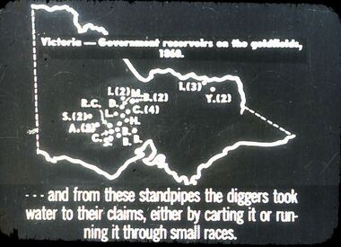 Bendigo Historical Society Inc.
Slide - DIGGERS & MINING. GETTING THE GOLD, c1860
... Diggers & Mining. Getting the Gold. Slide: Map of Victoria... the Gold. Slide: Map of Victoria. Victoria - Government reservoirs ...Diggers & Mining. Getting the Gold. Slide: Map of Victoria. Victoria - Government reservoirs on the goldfields, 1860. Letters on map relate to the position of the reservoirs standpipes. And from these standpipes the diggers took water to their claims, either by carting it or running it through small races. Markings: 72 994.LIF:4. Used as a teaching aid.hanimounteducation, tertiary, goldfields -
 Bendigo Military Museum
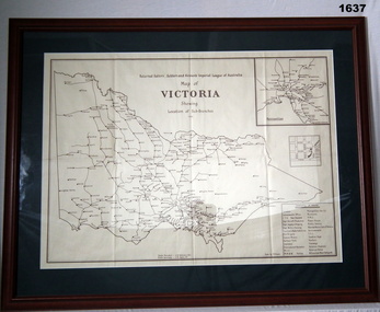
Map - MAP, FRAMED, Bethany Gallery, 1949
... Imperial League of Australia Map of Victoria showing Sub Branches... Map of Victoria showing Sub Branches 1949” Stamped on rear ...This map originally came via Mitiamo East Loddon RSL who when they closed their Sub branch the map and their records were handed to the Bendigo RSL for safe keeping. It was framed and was hanging in the Office of the SMI until the renovations to the building in 2016.Dark green mount with brown wooden frame. Brown printing on cream paper. Perspex covering map.Top centre of map: “Returned Sailors, Soldiers & Airmen's Imperial League of Australia Map of Victoria showing Sub Branches 1949” Stamped on rear: Bethany Gallery. Traditionally a touch of Excellence Terry ? Jarvis, 116 Bridge Street, Bendigo Vic 3550 Ph (03) 5442 4771brsl, smirsl, map rsl's -
 Orbost & District Historical Society
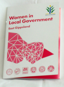
book, Women in Local government, 2015
... is a stylised map of Victoria divided into shires with the East... Gippsland Shire Council logo. In the centre is a stylised map ...This book was produced by East Gippsland Shire Council's Communication Unit - Janek Krause, Emma Langres and David Radford. It was supported by East Gippsland Historical society an Tim Gibson. This book celebrates the work of women in local government in East Gippsland. It is an excellent reference tool.A 42 pp stapled book titled, Women in Local Government. It is a collection of stories of women who have served as councillors in East Gippsland. The cover is white with magenta print,. In the top right corner is the East Gippsland Shire Council logo. In the centre is a stylised map of Victoria divided into shires with the East Gippsland shire highlighted.local-government east-gippsland women-in-government -
 Bendigo Historical Society Inc.
Slide - DIGGERS & MINING. THE GOLD LICENCE, c1854
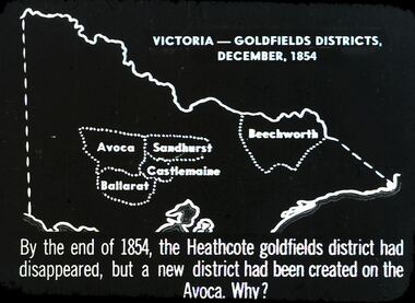
... . Slide depicts map of Victoria with the 5 gold rush regions... licence. The Government Camp. Slide depicts map of Victoria ...Diggers & Mining. The gold licence. The Government Camp. Slide depicts map of Victoria with the 5 gold rush regions marked on it. Beechworth, Sandhurst Avoca, Castlemaine and Ballarat. By the end of 1854, the Heathcote goldfields district had disappeared, but a district had been created on the Avoca. Why? Markings: 31 994.LIF. 4. Used as a teaching aid.hanimounteducation, tertiary, goldfields -
Clunes Museum
Memorabilia - BANNER
... . Map of Victoria, pictures showing mining, sheep, trees at top ... banner, white with red fringe, red cord at top. Map of Victoria ...Clunes Lion's Club operated 1975-1998.1 Lions International Badge. Adhesive emblem of yellow and royal blue, large white "L" in centre circle, lion's face, facing outwards on either side. "LIONS" at top "International" at bottom .2 Small banner, white with red fringe, red cord at top. Map of Victoria, pictures showing mining, sheep, trees at top .1 "Lions International" .2 "Clunes Lions Club" 201VA, Gold 'n' Fleece, Victoria, Australiaclunes lions club, lions club emblem -
 Bendigo Historical Society Inc.
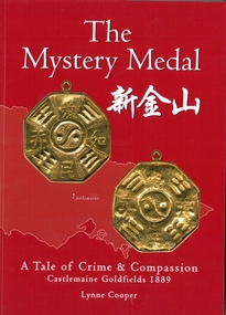
Book - The Mystery Medal. A Tale of Crime and Compassion. Castlemaine Goldfields 1889, Lynne Cooper, 2024
... of two sides of a gold coloured medal. map of Victoria outline... of a gold coloured medal. map of Victoria outline in background ...Biography of Henry William Frood who served 32 years as a member of the Victorian Police Force. Written by his great granddaughter Lynne Cooper. Soft cover book. Red soft cover with images of two sides of a gold coloured medal. map of Victoria outline in background. Illustrated with black and white and coloured photographs. 98 pp. Hand written on the Dedication page in gold coloured texta "Lynne Cooper Bendigo 2024 Available from: Goldfields Library & The Golden dragon Museum".henry william frood, chinese, medals -
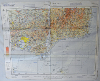 Orbost & District Historical Society
map, 1985
... A laminated map of eastern Victoria. A World Aeronautical... map of eastern Victoria. A World Aeronautical Chart. It shows ...An aeronautical chart is a map designed to assist in navigation of aircraft. Using these charts and other tools, pilots are able to determine their position, safe altitude, best route to a destination, navigation aids along the way, alternative landing areas in case of an in-flight emergency, and other useful information such as radio frequencies and airspace boundaries. World aeronautical charts have a scale of 1:1,000,000 and cover relatively large areas. Orbost Aero Club began in 1969 with Basil Dowie as Chair, David Nixon as Secretary/Treasurer. The group went into recess from 1977-1991 closing in 1997. The mid 1960s were boom years in flying training in Australia and the number of Aero Clubs grew rapidly. The Club played a significant role in the establishment of the small airport at Marlo and in the ongoing operation and development of the airport over the years particularly for patient transfer by aerial ambulance. The Orbost Aero Club Club played a significant role in the establishment of the small airport at Marlo and in the ongoing operation and development of the airport over the years.A laminated map of eastern Victoria. A World Aeronautical Chart. It shows elevations, longitude etc and is designed for pre-flight planning as well as pilotage. Top left hand corner - D.F.N.Nixon VH-FWD 12 Kristine Ct Cheletenham 27/7/87orbost-aero-club aeronautical-map -
Glenelg Shire Council Cultural Collection
Domestic object - Coaster, n.d
... ' printed in blue and green ink in the centre of a black outline map... in the centre of a black outline map of Victoria. Portland Development ...Circular cardboard coaster, with 'Prosper in Portland' printed in blue and green ink in the centre of a black outline map of Victoria. Portland Development Committee, 63 Julia Street, Portland. Victoria 3305 ph (055) 232757' printed in a circle around the edge, between two black lines, 1 cm apart. Coaster size 9.3 cm Diameter -
 Bendigo Historical Society Inc.
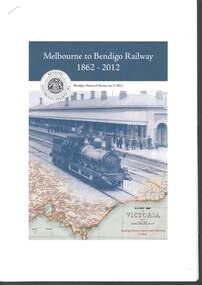
Book - RAILWAYS COLLECTION: MELBOURNE TO BENDIGO RAILWAY 1862-2012
... of a Railway map of Victoria,1947.... of a Railway map of Victoria,1947. Book RAILWAYS COLLECTION: MELBOURNE ...RAILWAYS COLLECTION -Booklet - Melbourne to Bendigo Railway 1862-2012. Produced by the Bendigo Historical Society Inc. in 2012 Editor Jim Evans. Paper booklet 21x30 cm stapled. The front cover shows a photo of steam Train (appears to be an A Class Loco) at Bendigo Railway Station C 1860's and part of a Railway map of Victoria,1947.Jim Evansbook -
 Whitehorse Historical Society Inc.
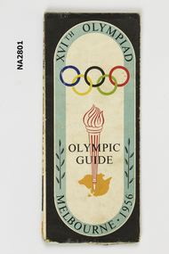
Memorabilia - Programme - Olympic, 1956
... of Melbourne and suburbs. Map of N.S.W. and Victoria.... of Melbourne and suburbs. Map of N.S.W. and Victoria. Memorabilia ...Program and guide map of city of Melbourne. Map of Melbourne and suburbs. Map of N.S.W. and Victoria.XVIth Olympiad Olympic Guide, Melbourne 1956.documents, programmes -
 Marysville & District Historical Society
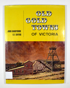
Book, Old Gold Towns of Victoria, 1970
... is a drawn map of Victoria showing all the towns mentioned... map of Victoria showing all the towns mentioned in the book ...Histories of the old gold towns in VictoriaHardback. Yellow dust cover. Front of jacket illustration-The Diggings, Ballarat. The poppet head, battery house, and mullock heap are typical of an old gold mine, and have been restored on Sovereign Hill over the old North Normandy mine. Back of jacket-The Bend in the Road, at Clunes. Inside both front and back cover is a drawn map of Victoria showing all the towns mentioned in the book. Stamp of the Marysville & District Historical Society Inc / P.O. Box 22 / Marysville 3779 Signature of H M Olivergold town, victoria, australia, history -
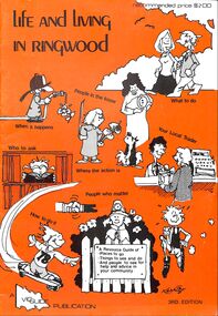 Ringwood and District Historical Society
Booklet, Life and Living in Ringwood (1979)
... includes Municipality map of Ringwood, Victoria, Australia.... Municipality map of Ringwood, Victoria, Australia. Life and Living ...Orange covered Ringwood Community Guide - 1979, containing details of local Community Services and Business Listings. Also includes Municipality map of Ringwood, Victoria, Australia.A Resource Guide of - Places to go - Things to see and do - And people to see for helpand advice in your community. -
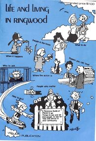 Ringwood and District Historical Society
Booklet, Life and Living in Ringwood (1977)
... includes Municipality map of Ringwood, Victoria, Australia.... map of Ringwood, Victoria, Australia. Life and Living ...Blue covered Ringwood Community Guide - 1977, containing details of local Community Services and Business Listings. Also includes Municipality map of Ringwood, Victoria, Australia.A Resource Guide of - Places to go - Things to see and do - And people to see for helpand advice in your community. -
Lakes Entrance Historical Society
Photograph - Lakes Entrance Fishermen, Bulmer, 1960 c
... studying maps Lakes Entrance Victoria..., Vernon Newman studying maps Lakes Entrance Victoria Photograph ...Black and white photograph of fishermen Rex Greer, Chum, Chris Newman, Frank Newman, Ronnie Newman, Vernon Newman studying maps Lakes Entrance Victoriapeople, fishermen -
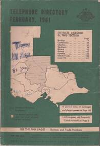 Bendigo Historical Society Inc.
Book - TELEPHONE DIRECTORY FEBRUARY 1961, February 1961
... background with an outline of the map of Victoria in white... Hill. Cover has a green background with an outline of the map ...Soft covered Telephone Directory February 1961. Districts covered are Bendigo, Castlemaine, Charlton, Deniliquin, Echuca, Kerang, Kyneton, Maryborough, Swan Hill. Cover has a green background with an outline of the map of Victoria in white. The Victorian Telephone directory boundaries are indicated and the district covered is shaded with black dots. Some handwritten jottings are written in ink on the cover. The directory contains both white and pink pages.book, bendigo, bendigo history & its people -
Whitehorse Historical Society Inc.
Map, Directory Maps of the County of Bourke, 1892
... also a complete map of the Colony of Victoria, showing all... the Parishes ... also a complete map of the Colony of Victoria, showing... Mitcham melbourne also a complete map of the Colony of Victoria ...Directory maps of the County of Bourke, containing all the Parishes ...Directory maps of the County of Bourke, containing all the Parishes ... also a complete map of the Colony of Victoria, showing all the Counties, Parishes, Railways and stations to date, and the Mallee Blocks. Lithographed by G.S.B. Bonney for the Victorian Shire Map Company. Scale: 40 chains to the inch.Directory maps of the County of Bourke, containing all the Parishes ...maps, victoria. county of bourke, t.r.b. morton & son -
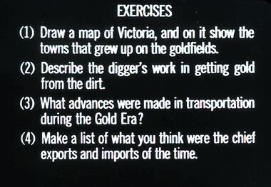 Bendigo Historical Society Inc.
Slide - DIGGERS & MINING: THE GOLD ERA, c1850s
... Diggers & mining. The gold era. Exercises (1) Draw a map... era. Exercises (1) Draw a map of Victoria, and on it show ...Diggers & mining. The gold era. Exercises (1) Draw a map of Victoria, and on it show the towns that grew up on the goldfields. (2) Describe the digger's work in getting gold from the dirt. (3) What advances were made in transportation during the Gold Era? (4) Make a list of what you think were the chief exports and imports of the time. Markings 57 994.031 GOL:5. Used as a teaching aid.hanimounteducation, tertiary, goldfields -
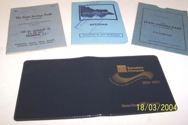 Whitehorse Historical Society Inc.
Book - State Savings Bank Books
... cloth cover with map of Victoria embossed in dark blue. 139... with map of Victoria embossed in dark blue. 139--153 Elizabeth ...Donor is a member of the Whitehorse Historical SocietyTwo State Savings Bank of Victoria bank books with blue cloth cover with map of Victoria embossed in dark blue. 139--153 Elizabeth Street branch 1956 (829444) 1960/68 (16616) Mitcham Branch. Plus state Savings Bank of Victoria Passbook cover, pale blue cardboard. Plus Travelers Cheques cover 1891-1999 State Bank Victoria. Very dark blue vinyl .The State Savings Bank of Victoriacommerce, banking -
University of Melbourne, Burnley Campus Archives
geological survey - Map, Maps of Geelong and Portarlington areas, 1963
... geological survey map of Portarlington, Victoria. By Dept. Of Mines... survey map of Portarlington, Victoria. By Dept. Of Mines ...A. Coloured geological survey map of Geelong area: showing sedimentary and igneous rock formations and contours. B. Coloured geological survey map of Portarlington, Victoria. By Dept. Of Mines, Melbourne.geological survey, geelong, portarlington -
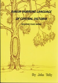 Bendigo Historical Society Inc.
Book - DJADJA WURRUNG LANGUAGE OF CENTRAL VICTORIA INCLUDING PLACE NAMES, 1997
... Dadja wurrung language of central victoria 92 pages... victoria 92 pages with photos, illustrations and maps. Published ...Dadja wurrung language of central victoria 92 pages with photos, illustrations and maps. Published in Maryborough Victoria.John Tullyaboriginal, language, djadja wurrung, djadja wurrung, aboriginal language, bendigo aborigine