Showing 19303 items
matching market-place
-
 Eltham District Historical Society Inc
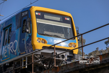
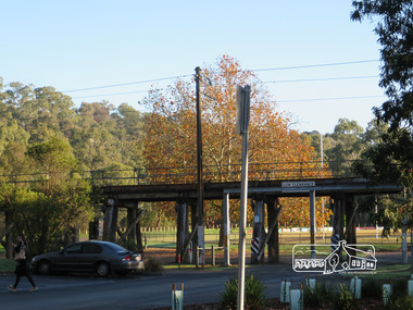
Photograph, Peter Pidgeon, Eltham Railway Trestle Bridge, Panther Place, Eltham, 1 August 2018, 1 Aug 2018
Born digital imageeltham, metro trains, panther place, trestle bridge -
 Eltham District Historical Society Inc
Photograph, Peter Pidgeon, Victorian Labor Government Press Release announcing planned upgrades to Hurstbridge line rail services and protection of historic Railway Trestle Bridge, Panther Place, Eltham, 1 August 2018, 1 Aug 2018
Announcement by Premier Daniel Andrews, Minister for Public Transport, Jacinta Allan and Member for Eltham, Vicki Ward mad alongside the Eltham Railway Trestle Bridge. MEDIA RELEASE "More Trains And Fewer Delays On The Hurstbridge Line" https://www.premier.vic.gov.au/wp-content/uploads/2018/08/180801-More-Trains-And-Fewer-Delays-On-The-Hurstbridge-Line-1.pdf Commuters on the Hurstbridge line will have more trains, more seats and fewer delays with a re-elected Andrews Labor Government to continue its massive upgrade of the Hurstbridge line. The Andrews Labor Government said it would deliver locals in Melbourne’s north-east more peak hour train services and less time stuck at boom gates, and we have. The first stage of the Hurstbridge Line Upgrade has been delivered – six months early and on budget. This includes the new Rosanna Station, duplicated track between Heidelberg and Rosanna and the removal of the dangerous level crossings at Alphington and Rosanna. There’s more to do and only Labor will deliver the next stage of the Hurstbridge Line Upgrade to give local commuters more train services and a more comfortable commute. The $530 million project will include a brand new train station at Greensborough and the duplication of three kilometres of track between Greensborough and Montmorency, and 1.5 kilometres of track between Diamond Creek and Wattle Glen to allow more train services during the morning peak. This will allow trains to run every six and a half minutes at Greensborough, every 10 minutes at Eltham and Montmorency, and every 20 minutes at Hurstbridge, Diamond Creek and Wattle Glen – as well as two extra Hurstbridge express services. Locals on the Labor Government’s new Mernda line will also get five extra train services during the morning peak, with a major upgrade of the Clifton Hill junction where the Mernda and Hurstbridge lines connect. Labor will also protect the Eltham Trestle Bridge – the last remaining timber bridge on Melbourne’s electric train network – which has local heritage protection and is an important part of the area’s character. The Liberals will leave this bridge to rot and demolish the nearby childcare centre and football club with their under-cooked and under-costed promise to upgrade the Hurstbridge line. Only Labor will protect this important piece of Melbourne’s history with planning work to be carried out for a long-term solution as part of the project. Stage two of the Hurstbridge Line Upgrade will create more than 950 jobs, with construction to start in 2020 and finish by 2022. Quotes attributable to Premier Daniel Andrews “We said we’d upgrade the Hurstbridge line and remove dangerous and congested level crossings at Rosanna and Alphington and we did – but there’s more to do.” “Only Labor will deliver the next stage of the Hurstbridge Line Upgrade with a new Greensborough Station and more trains, more often.” Quote attributable to Minister for Public Transport Jacinta Allan “The former Liberal Government promised new train lines but didn’t deliver a single kilometre of track – now they’re promising a half-baked upgrade of the Hurstbridge line with rubbery figures that don’t add up.” Quote attributable to Member for Eltham Vicki Ward “As a fifteen year old hopping on Red Rattlers at Eltham I wanted to do something to make the Hurstbridge line better. It’s taken me a few decades but finally our line will offer the frequency of services that are expected and needed in a 21st century city.”Born digital image (qty 27)jacinta allan, minister for public transport, panther place, premier daniel andrews, press announcement, railway line construction, trestle bridge, vicki ward mp for eltham, victorian parliament -
 Eltham District Historical Society Inc
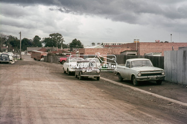
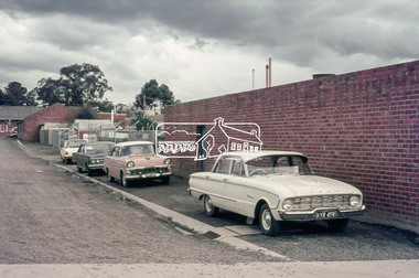
Photograph, Laneway running between Arthur Street and Luck Street (now Commercial Place), Eltham, c.6 May 1968, 1968
35mm Colour positive transparency Mount - Agfacolor Service (Blue stepped)arthur street, carparks, commercial place, eltham real estate, luck street, millets, pryor street, real estate agent, -
 Eltham District Historical Society Inc
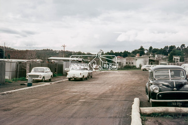
Photograph, Laneway running between Arthur Street and Luck Street (now Commercial Place), Eltham, c.6 May 1968, 1968
35mm Colour positive transparency Mount - Agfacolor Service (Blue stepped)commercial place, luck street, pryor street -
 Eltham District Historical Society Inc
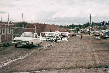
Photograph, Laneway running between Arthur Street and Luck Street (now Commercial Place), Eltham, c.6 May 1968, 1968
35mm Colour positive transparency Mount - Agfacolor Service (Blue stepped)carparks, commercial place, luck street, pryor street -
 Eltham District Historical Society Inc
Photograph, Laneway running between Arthur Street and Luck Street (now Commercial Place), Eltham, c.6 May 1968, 1968
35mm Colour positive transparency Mount - Agfacolor Service (Blue stepped)arthur street, commercial place, eltham shire hall, pryor street -
 Eltham District Historical Society Inc
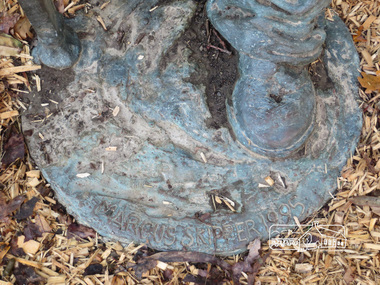
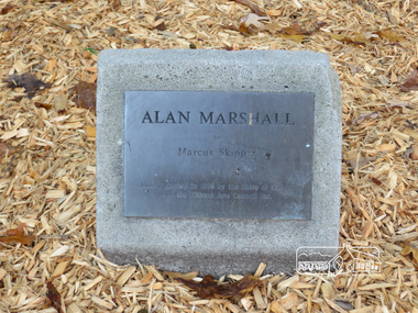
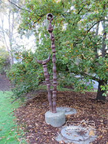
Photograph, Liz Pidgeon, Alan Marshall by Marcus Skipper (1995) outside Eltham Library, Panther Place, 21 May 2014, 21 May 2014
Born Digitalart in public places, alan marshall, marcus skipper, sculptures, eltham library -
 Eltham District Historical Society Inc
Photograph, Liz Pidgeon, Alan Marshall by Marcus Skipper (1995) outside Eltham Library, Panther Place, 21 May 2014, 21 May 2014
Born Digitalart in public places, alan marshall, marcus skipper, sculptures, eltham library -
 Eltham District Historical Society Inc
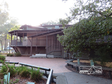
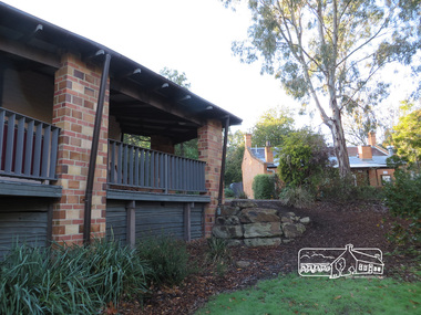
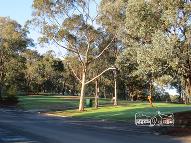
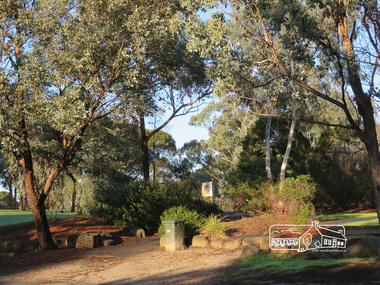
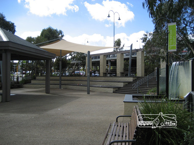
Photograph, Liz Pidgeon, Eltham Library, Panther Place, 21 May 2014, 21 May 2014
Born Digitaleltham library, panther place -
 Eltham District Historical Society Inc
Photograph, Liz Pidgeon, Eltham Library, Panther Place, 21 May 2014, 21 May 2014
Born Digitaleltham library, panther place -
 Eltham District Historical Society Inc
Photograph, Liz Pidgeon, Eltham Library, Panther Place, 21 May 2014, 21 May 2014
Born Digitaleltham library, panther place -
 Eltham District Historical Society Inc
Photograph, Liz Pidgeon, Eltham Library, Panther Place, 21 May 2014, 21 May 2014
Born Digitaleltham library, panther place -
 Eltham District Historical Society Inc
Photograph, Liz Pidgeon, Eltham Library, Panther Place, 21 May 2014, 21 May 2014
Born Digitaleltham library, panther place -
 Eltham District Historical Society Inc
Photograph, Liz Pidgeon, Trestle Bridge near, Eltham Library, Panther Place, 21 May 2014, 21 May 2014
Born Digitaleltham library, panther place, trestle bridge -
 Eltham District Historical Society Inc
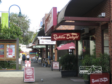
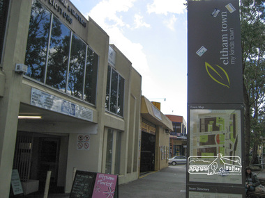
Photograph, Liz Pidgeon, Commercial Place, Eltham, 15 April 2011, 15 April 2011
Streetscape and shop developmentsBorn Digitaleltham, commercial place, shopping centre -
 Eltham District Historical Society Inc
Photograph, Liz Pidgeon, Commercial Place, Eltham, 15 April 2011, 15 April 2011
Streetscape and shop developmentsBorn Digitaleltham, commercial place, shopping centre -
 Eltham District Historical Society Inc
Photograph, Liz Pidgeon, Commercial Place, Eltham, 15 April 2011, 15 April 2011
Streetscape and shop developmentsBorn Digitaleltham, commercial place, shopping centre -
 Eltham District Historical Society Inc
Photograph, Liz Pidgeon, Mail delivery, Stokes Place, 18 February 2011, 18 February 2011
Born Digitaleltham, post office -
 Whitehorse Historical Society Inc.
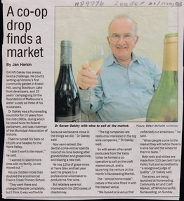
Article, A Co-op drop finds a market, 2003
Gavan Oakley, ex Nunawading Councillor, has now started a co-operative making wine in the Yarra Valley. He is launching his venture at Nunawading Market.Gavan Oakley, ex Nunawading Councillor, has now started a co-operative making wine in the Yarra Valley. He is launching his venture at Nunawading Market.Gavan Oakley, ex Nunawading Councillor, has now started a co-operative making wine in the Yarra Valley. He is launching his venture at Nunawading Market.viticulture, oakley, gavan, nunawading market -
 Ringwood and District Historical Society
Manila Folder, Notes for Ringwood book "Place of Many Eagles" incl Eastland. 1915-1987, 1915 - 1987
Collection of notes for the book 'Place of Many Eagles' with some details of shopkeepers and businesses of local interest.Manila folder containing notes on local shops - particularly Eastland. Collection of notes for the book 'Place of Many Eagles'. +Additional Keywords: Anderson, Hugh -
 Marysville & District Historical Society
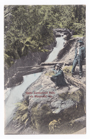
Postcard (item) - Colour tinted postcard, Victorian Stamp Market, Upper Cumberland Falls, via Marysville, Vic, 1908
An early colour tinted photograph of the Upper Cumberland Falls near Cambarville in Victoria. This postcard was published by Victorian Stamp Market as a souvenir of Marysville. An early colour tinted photograph of the Upper Cumberland Falls near Cambarville in Victoria. These falls are located on the Marysville-Wood's Point Road. Cambarville is notable for its giant mountain ash (Eucalyptus regnans) trees within the Cumberland Memorial Scenic Reserve, and relics from former sawmills and gold mining. The Big Culvert is located nearby on the Marysville - Woods Point Road, which was historically part of the Yarra Track. Cambarville was established as a timber mill town in the 1940s. Timber mill owners A Cameron and FJ Barton named Cambarville. They established the mill to salvage timber from trees destroyed in the 1939 bushfires. Cambarville was impacted by the 2009 Black Saturday bushfires and any remaining structures were destroyed.POST CARD This space may be used for Correspondence. FOR ADDRESS ONLY Printed in Germany V.S.M. Seriescumberland falls, cambarville, marysville, victoria, waterfalls, postcard, souvenir, mountain ash, mining, timber mills, big culvert, yarra track, a cameron, fj barton, black saturday bushfires, 1939 bushfires, eucalyptus regnans, victorian stamp market, victorian stamp market series -
 Marysville & District Historical Society
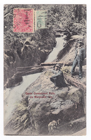
Postcard (item) - Colour tinted postcard, Victorian Stamp Market, Upper Cumberland Falls via Marysville, Vic, 1908
An early colour tinted photograph of the Upper Cumberland Falls near Cambarville in Victoria. This postcard was published by Victorian Stamp Market as a souvenir of Marysville. An early colour tinted photograph of the Upper Cumberland Falls near Cambarville in Victoria. These falls are located on the Marysville-Wood's Point Road. Cambarville is notable for its giant mountain ash (Eucalyptus regnans) trees within the Cumberland Memorial Scenic Reserve, and relics from former sawmills and gold mining. The Big Culvert is located nearby on the Marysville - Woods Point Road, which was historically part of the Yarra Track. Cambarville was established as a timber mill town in the 1940s. Timber mill owners A Cameron and FJ Barton named Cambarville. They established the mill to salvage timber from trees destroyed in the 1939 bushfires. Cambarville was impacted by the 2009 Black Saturday bushfires and any remaining structures were destroyed.POST CARD This space may be used for Correspondence. FOR ADDRESS ONLY Printed in Germany V.S.M. Series WOOD / VICT/ A/ 10 -4.S.10-3/ DISTRIBUZIONS JWO Gricardi/ Via Galletti/ V 16/ Loruis/ Italy Mary A????/ Australiacumberland falls, cambarville, marysville, victoria, waterfalls, postcard, souvenir, mountain ash, mining, timber mills, big culvert, yarra track, a cameron, fj barton, black saturday bushfires, 1939 bushfires, eucalyptus regnans, victorian stamp market, victorian stamp market series -
 Orbost & District Historical Society
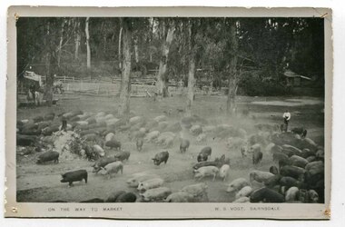
black and white photograph, late 19th century - early 20th century
Pigs were taken to Bairnsdale by coaxing them with maize thrown from a wagonette . From Bairnsdale they were freighted to market by train. The journey to Bairnsdale took about five days . This method of transport continued until the rail line to Orbost was opened in 1916. This photograph is a pictorial record of Orbost farming practices in the early 20th century.A black / white photograph of pigs being taken to market. There are men on horseback with them.on front - On the Way to Market W.S. Vogt Bairnsdaleagriculture farming-orbost pigs -
 Flagstaff Hill Maritime Museum and Village
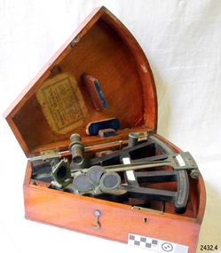
Instrument - Octant, mid 1800's
An Octant is a doubly reflecting navigation instrument used primarily by sailors to measure the angular distance between two visible objects and was a forerunner of the sextant. The name comes from the Latin octo, or "one-eighth of a circle," for the Octan'ts arc which spans 45°, or one-eighth of a circle. The primary use of an Octant is to measure the angle between an astronomical object and the horizon for celestial navigation. The estimation of this angle, is known as sighting or shooting the object, or taking a sight. The angle, and the time when it was measured, can be used to calculate a position line on a nautical chart (latitude), for example, sighting the Sun at noon or Polaris at night (in the Northern Hemisphere) gives an angle by which the latitude can then be estimated. Sighting the height of a landmark on land can also give a measure of distance. This fine octant once belonged to Captain Farquhar Chisholm and was donated by his granddaughter, Margaret Ruth Greer (nee Chisholm, born 1914). The label inside the Octant's box reads “Thomas L. Ainsley, Instrument Maker … etc”. Farquhar Chisholm was born in 1832 in Inverness, Scotland. He regularly sailed on perilous voyages between Quebec, Canada and the Baltic ports of Europe. In 1854 he migrated to Australia during the Gold Rush, to a place called Fiery Creek (near Beaufort Victoria) where he was fairly successful in his quest for gold. In the years of the Great Gold Rush, it was said that there were over 40,000 diggers in the goldfields of the Beaufort area! In 1857 having made sufficient money, he hired another crew and returned to Clachnacuddin, Inverness shire, Scotland and in that same year, he studied and obtained his Master Mariner Certificate (which would have included the use of an octant for navigation). He was appointed to Mr George (or James) Walker, as commander of his sailing ship, the 3-masted ELIZABETH, built 1859 and known as “The Walker barque”. In 1870 he married, then in 1887 returned to Australia with his wife and children (Kenneth Chisholm (1871), Mary Bremner Chisholm (1873), Margaret Hood Chisholm (1874), Farquhar Chisholm (1878)). They arrived in Port Melbourne, Victoria and sadly, only six weeks after landing, his wife Caroline passed away (in Geelong,1888). In 1900 Capt. Chisholm lived in Camperdown (Victoria) and not long after this his daughter Margaret died of consumption. In his later years, he went to live in the manse of St. Paul’s Presbyterian Church, Wangaratta, with his son, Rev. Farquhar Chisholm. He died there on Sat, 23rd March 1912, 80 years old. He was known as “… quiet, unobtrusive and competent, respected by all with whom he came in contact”. Some other members of Captain Chisholm’s family are; his older son Kenneth Chisholm, who was a contractor in Camperdown; a nephew Donald Macintosh (of 23 Douglas Row, Inverness); a grandson Brian Jones (son of Caroline Belle-Jones nee Chisholm, who lived in Camperdown in the earlier part of her life).The octant, the forerunner of the sextant, was a significant step in providing accuracy of a sailors latitude position at sea & his vessels distance from land when taking sightings of land-based landmarks.Octant, once belonging to Captain Farquhar Chisholm. Wedge shape (the size of an eighth of a circle), made of wood, glass and metal. Used in the 1880s. Maker’s name across centre “L. SIMON - - - SHIELDS”. Three (3) light filtering, coloured glass shades. Two (2) eyepieces. Scale attached for measuring angles. Label inside the fitted, wedge-shaped case "Thomas L. Ainsley, Optician"Label inside case "Thomas L. Ainsley, Optician" Maker’s name across centre “L. SIMON - - - SHIELDS”.flagstaff hill, warrnambool, shipwrecked-coast, flagstaff-hill, flagstaff-hill-maritime-museum, maritime-museum, shipwreck-coast, flagstaff-hill-maritime-village, maritime navigation, navigation instrument, migration, captain chisholm, farquhar chisholm, sailing ship, the elizabeths, thomas l. ainsley, l. simons, shields england, octant, john hadley, chisholm -
 Tatura Irrigation & Wartime Camps Museum
Photograph, Stuart Mock Place, Hogan Street, Tatura
Shows picture of Stuart Mock Place at the intersection of Francis and Hogan Streets, Tatura. Also old State Bank and real estate buildings.Colour photograph showing Stuart Mock Place at the intersection of Francis and Hogan Streets, Tatura. Photograph stuck onto piece of white cardboard. hogan street tatura, francis street tatura, stuart mock place tatura, state bank tatura -
 Ringwood and District Historical Society
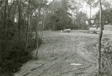
Photograph, Road and carpark construction works for Ringwood Market and Target Square shopping centres, viewed towards Charter and Seymour Streets from Bond Street, Ringwood - 1984
Written on back of photograph, "New roads after demolition of houses, Chartres and Seymour St. for Target Square and market". -
 Ringwood and District Historical Society
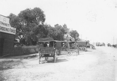
Photograph, Outside the Ringwood Market in Maroondah Hwy. 1925
Black and white photograph of street scene showing unmade road with horses and carts at roadsides and wooden buildings to left of photograph. (2 copies)Typed below photograph, "Outside the Ringwood Market in Maroondah Hwy. 1925. Shop in centre (is) at corner of Ringwood Street. ... ". -
 Ringwood and District Historical Society
Photographs, 1979-80 MMBW pipe line project at Hubbard Reserve, North Ringwood � Viewing east from Debbie Place
Part of a 43-photo record of the MMBW�s engineering feat in drilling a 12 inch pipe line up to 40 feet deep through rock hardened by volcanic action associated with geological fault that occurs along the line. The work took place from October 1979 to May 1980 on the southern boundary of Hubbard Reserve, North Ringwood. The collection was presented to the Ringwood Historical Research Group by J Clarke on 9th June 1980.E568 N18 13 May 1980 A43 Viewing east from ridge above Debbie Place -
 Ringwood and District Historical Society
Photographs, 1979-80 MMBW pipe line project at Hubbard Reserve, North Ringwood � View from Debbie Place, preliminary sewer work
Part of a 43-photo record of the MMBW�s engineering feat in drilling a 12 inch pipe line up to 40 feet deep through rock hardened by volcanic action associated with geological fault that occurs along the line. The work took place from October 1979 to May 1980 on the southern boundary of Hubbard Reserve, North Ringwood. The collection was presented to the Ringwood Historical Research Group by J Clarke on 9th June 1980.E561 N13 28 Feb 1980 A43 View from Debbie Place, preliminary sewer work -
Ringwood and District Historical Society
Manuscript, Anderson, Hugh, Text/Proof corrections for Ringwood book "Place of Many Eagles". C1980s, c. 1980s
Proof copy of several chapters of the book 'Place of Many Eagles':|1. Bushwalkers and Bullockies|2. That's what you call slavery|3. Suffering little childrenLarge pages of text with proof corrections done in preparation of the book 'Place of Many Eagles'. Several chapters. +Additional Keywords: Anderson, Hugh