Showing 140 items
matching mitcham guides
-
 Whitehorse Historical Society Inc.
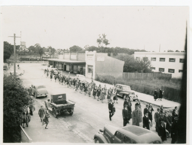
Photograph, Anzac Day, c1948
... Mitcham melbourne guide groups exservice organisations anzac day ...Black and white photo of Girl Guides and Returned Soldiers at Anzac Day march. Looking south along station street, Mitchamguide groups, exservice organisations, anzac day -
 Whitehorse Historical Society Inc.
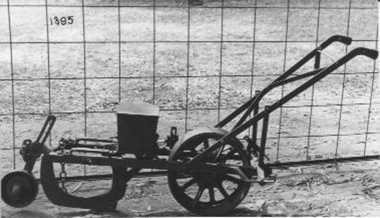
Machine - Corn and Bean Planter, C1920
Used on the Tainton orchard in the Canterbury Road. Forest Hill.Horse drawn, chain operated, hand guided planter which forms farrow, plants beans and firms down trench. fertiliser attachment missing.'Sunshine'rural industry, agriculture -
 Whitehorse Historical Society Inc.
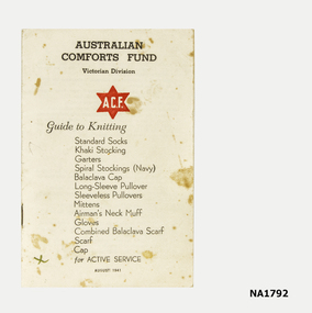
Book - Australian Comforts Fund Book, Australian Comforts Fund, 1/08/1941 12:00:00 AM
Paper back instruction booklet for Comfort Fund Knitted articles.Australian Comforts Fund, Victorian Division A.C.F. Guide to knitting Standards Socks ---- Scarf, Cap.books, reference -
 Whitehorse Historical Society Inc.
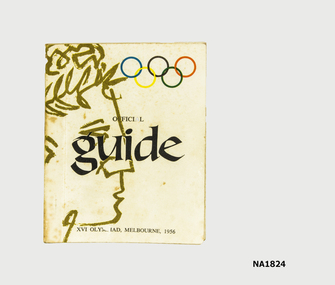
Book, 1956
Small booklet - Official guide to XVI Olympics, Melbourne, 1956.documents, programmes -
 Whitehorse Historical Society Inc.
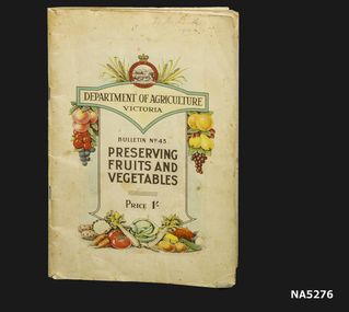
Booklet - Booklet - Guide to Fruit & Vegetable preserving, Preserving fruits & vegetables, C 1940's
Marked 'D M Smith 1944'A booklet from the Victorian Dept of Agriculture detailing 'Preserving fruits & vegetables'.Dept of Agriculture, Victoria Bulletin No 43. 'Preserving fruits and vegetables'. Price 1 shilling.instructional preserving cookbook -
 Whitehorse Historical Society Inc.
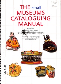
Book - The Small Museums Cataloguing Manual, 1996
... Mitcham melbourne A guide to cataloguing object, document ...A guide to cataloguing object, document and image collection. 3rd. EdA guide to cataloguing object, document and image collections for small museumsPaperback. Ring bound. A4, 18pcataloguing, museums -
 Whitehorse Historical Society Inc.
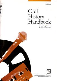
Book - Oral History Handbook, 1997
... Mitcham melbourne Comprehensive guide to oral history methods ...Comprehensive guide to oral history methods and proceduresComprehensive guide to oral history methods and proceduresComprehensive guide to oral history methods and proceduresoral history, history, local history -
 Whitehorse Historical Society Inc.
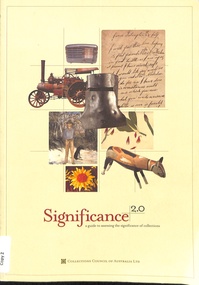
Book - Significance 2.0, 2009
The Collections Council of Australia guide to assessing the significance of collectionsThe Collections Council of Australia guide to assessing the significance of collectionsThe Collections Council of Australia guide to assessing the significance of collectionsmuseums, heritage studies -
 Whitehorse Historical Society Inc.
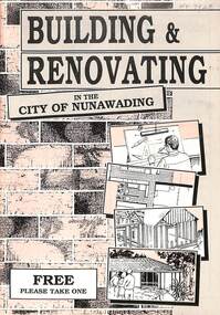
Booklet, Building and Renovating, 1988 or 1989
City of Nunawading requirements of Owner Buildersnon-fictionCity of Nunawading requirements of Owner Builderscity of nunawading, buildings -
 Whitehorse Historical Society Inc.
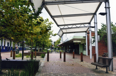
Photograph, Brittania Mall Mitcham
The Brittania Mall was part of a $5 million development of the Mitcham Shopping centre, begun in 1986. It affected both Edward Street and Brittania Street, part of which had to be re-routed. The guide hall in Brittania Street was removed to Halliday Park Mitcham. The development included extension of the New World Supermarket(now Coles) and a two level carpark.Coloured photograph of the Britannia Mall, Mitcham taken from the north end. Traffic in the distance is on Whitehorse Road - 2012shops, britannia mall, mitcham -
 Whitehorse Historical Society Inc.
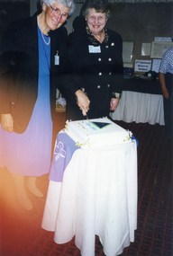
Photograph, Vermont Girls Guides 70th Anniversary in 1999
... Mitcham melbourne vermont girl guides courtney lucy cuttle jessie ...Coloured photograph of Lucy Courtney and Jessie Cuttle cutting the cake at the Vermont Girl Guides 70th Anniversary at St John's Hall, Vermont in 1999vermont girl guides, courtney, lucy, cuttle, jessie -
 Whitehorse Historical Society Inc.
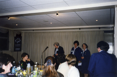
Photograph, Vermont Girl Guides 70th Anniversary in 1999
... Mitcham melbourne vermont girl guides wallbridge elaine st john's ...Coloured photograph of the celebrations at the 70th anniversary of the Vermont Girl Guides in June 1999. Venue is St John's church hall in Mitcham. At the microphone is Mrs Elaine Wallbridge who was the Nunawading/Mount Pleasant Division Commissioner 1981 - 1986.vermont girl guides, wallbridge, elaine, st john's catholic church hall, mitcham -
 Whitehorse Historical Society Inc.
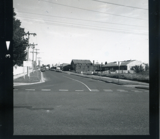
Photograph, Britannia Street c. 1987, c. 1987
... mitcham guide hall... mitcham guide hall mitcham angling club Black and white photograph ...Black and white photograph of Britannia Street, Mitcham, looking south. c. 1987. Note the Angling Club (foreground) and the original Scout Hall, later the Guide Hall. The hall was built c. 1920britannia street, mitcham, mitcham scout hall, mitcham guide hall, mitcham angling club -
 Whitehorse Historical Society Inc.
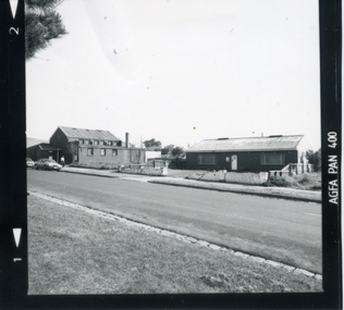
Photograph, Britannia Street, Mitcham, c. 1987
... mitcham guide hall... Mitcham melbourne britannia street mitcham mitcham guide hall ...Black and white photograph of Britannia St., Mitcham, looking south west, showing the Guide Hall (left) and Anglers club (right)britannia street, mitcham, mitcham guide hall, mitcham angling club -
 Whitehorse Historical Society Inc.
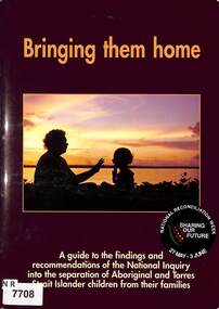
Document - Government Report, Australian Human Rights Commission, Bringing them home : a guide to the findings and recommendations of the National Inquiry into the Separation of Aboriginal and Torres Strait Islander children from their families, 1997
... Mitcham melbourne This guide provides photographs and context via ...A guide to the findings and recommendations of the National Inquiry into the separation of Aboriginal and Torres Strait Islander children from their families.A4 50 pp booklet, glossy paper, in colour, photographs and print. report of the National Inquiry into the Separation of Aboriginal and Torres Strait Islander Children from their Families non-fictionA guide to the findings and recommendations of the National Inquiry into the separation of Aboriginal and Torres Strait Islander children from their families.aborigines, children, administration law -
 Whitehorse Historical Society Inc.
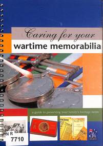
Document - Pamphlet, Department of Veteran Affairs, Caring for Your Wartime Memorabilia, 2001
... Mitcham melbourne A guide to assist with the preservation ...A guide to preserving wartime memorabiliaCaring for your wartime memorabilia.non-fictionA guide to preserving wartime memorabiliapreservation, war, memorabilia -
 Whitehorse Historical Society Inc.
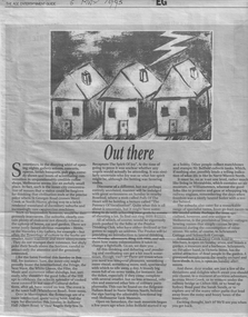
Article, Out There, 05/05/1995
A 1995 newspaper article mentioning Schwerkolt Cottage as an interesting place to visitnon-fictionA 1995 newspaper article mentioning Schwerkolt Cottage as an interesting place to visitschwerkolt cottage & museum complex, heritage buildings -
 Whitehorse Historical Society Inc.
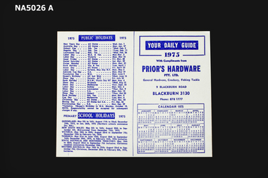
Souvenir - Calendar & Information Guide, 1975, 1975
Produced by Prior's Hardware to advertise their business and assist customers. Used in 1975 in Blackburn, Victoria, Australia.Daily guide produced for Prior's Hardware Pty Ltd. Includes 1975 calendar, public holidays 1975, school holidays 1975, postage rates, phases of the moon, child endowment, birthstone, flowers, wedding anniversaries, metric conversion tables, important phone numbers, birthday reminders.Prior's Hardware Pty Ltd. General Hardware, crockery, fishing tackle. 9 Blackburn Road Blackburn 3130. Phone 8781777.shopping, prior's hardware, 9 blackburn road blackburn -
 Melbourne Tram Museum
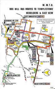
Map, Melbourne & Metropolitan Tramways Board (MMTB), Set of 8 bus route maps, 1977 to 1979
Series of colour route maps for various bus or groups of tram lines for the MMTB. Some have the Transport Information Centre telephone printed on them, others have a label stuck on. Some are finished with a plastic laminate finish on either one or both sides. Show the major cross streets, parks, schools, other tram routes, major stop numbers and railway lines. .1 - Box Hill bus routes to Templestowe - R38/82, Heidelberg and East Kew, includes Doncaster, Shoppingtown and Newmans Road. .2 - Clifton Hill - R2/79 - Elsternwick, Point Ormond and St Kilda Junction .3 - Footscray, Sunshine, Deer Park, Nth Altona, Fishermen's Bend, Highpoint and Williamstown Road - R2/79. .4 - Bulleen - City - Port Melbourne - Garden City Bus Route, including Kew, Collingwood - R6/78 .5 - City - Warrandyte and East Doncaster including Newmans Road, Templestowe, East Doncaster, Donvale, Shopping town, and Kew. R3/82. .6 - West Heidelberg, La Trobe University, Northland - R3/81 .7 - Box Hill, Ringwood to East Doncaster and Warrandyte, Park Orchards, North Blackburn R3/82. .8 - Geelong - Herne Hill, Rollins Road, Donnybrook Rd, North Shore and Corio Villagetrams, tramways, maps, route guide, route numbers, routes, buses, box hill, templestowe, doncaster, east kew, heidelberg, clifton hill, point ormond, elsternwick, footscray, sunshine, deer park, north altona, fishermen's bend, highpoint, williamstown rd, bulleen, kew, collingwood, port melbourne, garden city, warrandyte, donvale, la trobe university, northland, ringwood, park orchards, mitcham, blackburn, geelong -
 Melbourne Tram Museum
Map, Melbourne & Metropolitan Tramways Board (MMTB), MMTB Route Maps, 1979
Series of colour maps for various tram and bus routes, dated 1979. Also contained, not scanned are letters, reports, and specifications for printing these maps for use in shelters etc. Some have the Transport Information Centre telephone printed on them. Some are finished with a plastic laminate finish on either one or both sides. Show the major cross streets, parks, schools, other tram routes, major stop numbers, and railway lines. See also item 3909 for another example of these. Trams 1 - City route guide - R9/77 - showing all route numbers and destinations that passed through the CBD. 2 - Bourke St tram routes - R4/77 - East Brunswick Blyth St and East Preston Tyler St and intermediate routes, routes 95, 96, 97, 90, 89 and 88. 3 - Malvern, East Malvern, Carnegie, and East Brighton Tram Routes (from St Kilda Junction) - R1/79 - shows routes 5, 3, 67, 66, 61, 62, and 64. 4 - Elizabeth St tram routes - R12/77 - Essendon Airport, West Maribyrnong, North Coburg lines, routes 50, 58, 60, 54, 57, 52. 49, 59, 18, 20 and 19 5 - Flinders St tram routes - R5/78 - North Balwyn, East Burwood, routes 48, 40, 41, Hartwell, 28, 74 and 75 6 - Kew - St Kilda Beach - R1/79 - Route 69. 7 - Mont - Albert City - R11/77, shows routes 43. 47. 45. 44 8 - St Kilda Rd Tram Routes R12/77 - details South Melbourne Beach, route 1 and route 2 and St Kilda Beach routes 15, 16, and 55 otherwise shows where the various routes branch off St Kilda Road 9 - Batman Ave tram routes - R9/77 - Wattle Park, North Richmond and Prahran - routes 70, 71, 78 and 79. 10 - Footscray - Moonee Ponds - R3/81 - Route 82 11 - Swanston St tram guide - R1/79 - lists all routes and route numbers that branch or cross Swanston St between Grattan St and St Kilda Junction. 12 - Toorak Camberwell and Glen Iris tram route with Camberwell Junction and Malvern Town Hall, R1/79, routes 8, 7, 6, 72, and 73 shown. 13 - West Preston - Beach tram routes - R12/77 - routes 10, 11, 9 and 12, 14 - William St tram routes - R12/77 - Route 55, 56, and 63 - South Melbourne Depot and Domain. Buses 1 - Footscray, Sunshine, Deer Park, Nth Altona & Fishermans Bend - R2/79 2 - Box Hill bus routes to Templestowe, Heidelberg & East Kew - R6/78 - notes superseded by R3/82 3 - Plan of Russell St Melbourne bus departure bays. 4 - Box Hill, Mitcham & Ringwood bus routes to East Doncaster & Warrandyte - R3/82 5 - City - Warrandyte & East Doncaster bus routes - R3/82 & R6/78 6 - Bulleen - City - Port Melbourne - Garden City Bus route - R6/78 7 - North Altona - City bus route - 11/78 8 - Clifton Hill - Elsternwick - R2/79 9 - La Trobe - Northland - West Heidelberg - City Bus Service via East Freeway - 11/79 and R3/81 10 - Box Hill, Mitcham & Ringwood Bus Routes to East Doncaster & Warrandyte - R10/84 - with the Metropolitan Transit logo.Yields information about tram and bus routes in late 1970s early 1980s.Book - brown comb binding, card and clear plastic covers containing both bound and unbound maps and documents.K C Painter on front cover in ink.tramways, mmtb, tram routes, maps, bus routes, route numbers, routes, route guide