Showing 252 items matching "mont park"
-
 Victorian Aboriginal Corporation for Languages
Book, City of Whitehorse, City Of Whitehorse parks and reserves: names and origins, 1985
Spiral bound book released by City of Whitehorse council. Alphabetically listed placenames within the local government area, with Melway map points and brief historical references to those places.Black and white photographs, colour photographsplace names, city of whitehorse, box hill, mitcham, mont albert, blackburn, surrey hills, burwood, nunawading, forest hill -
Whitehorse Historical Society Inc.
Document, Heritage Precincts Report 2004, 2004
Heritage Precincts report 2004, City of Whitehorse, with photos and maps of the precincts.Heritage Precincts report 2004, City of Whitehorse, with photos and maps of the precincts.Heritage Precincts report 2004, City of Whitehorse, with photos and maps of the precincts.mount view court precinct, burwood, blacks estate precinct, mont albert, thomas street precinct, mitcham, windsor park estate precinct, surrey hills -
Whitehorse Historical Society Inc.
Document, Windsor Park Estate, 2005?
... Mitcham melbourne Windsor Park Estate Surrey Hills Mont Albert ...City of Whitehorse individual Heritage properties review 2006: Study of Windsor Park Estate and 32 High Street.City of Whitehorse individual Heritage properties review 2006: Study of Windsor Park Estate and 32 High Street.City of Whitehorse individual Heritage properties review 2006: Study of Windsor Park Estate and 32 High Street.windsor park estate, surrey hills, mont albert, houses -
Whitehorse Historical Society Inc.
Newspaper, As Time Goes By, 2/10/1996 12:00:00 AM
City of Whitehorse, historical feature. Supplement to Whitehorse Post 2/10/1996.City of Whitehorse, historical feature. Supplement to Whitehorse Post 2/10/1996.City of Whitehorse, historical feature. Supplement to Whitehorse Post 2/10/1996.blackburn, mitcham, forest hill, nunawading, wattle park, box hill, burwood, surrey hills, mont albert, vermont -
 Whitehorse Historical Society Inc.
Article, Why Is It So?
How the eastern suburbs were named.ashburton, ashwood, ballyshanassy, balwyn, blackburn, black flat, box hill, burwood, camberwell, canterbury, deepdene, forest hill, glenferrie, glen iris, glen waverley, hawthorn, mont albert, mount waverley, nunawading, riversdale, surrey hill, vermont, wattle park -
 Australian Army Museum of Western Australia
Regimental Colour - 28th Battalion (The Swan Regiment)
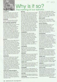
Presented by Lieutenant-General Sir JJ Talbot Hobbs, KCB, KCMG, VD, LLD at a parade held on the Esplanade, Perth, 22 October 1927. With the re-activation of the Citizen Military Forces (CMF) following the Second World War, the 16th/28th Infantry Battalion (The Cameron Highlanders of Western Australia) was raised as a linked battalion in 1948 to carry on the identity and traditions of the pre-war 16th and 28th Battalions respectively. The King's and Regimental Colours formerly held by these two battalions were passed on to the new battalion who paraded them in rotation on ceremonial occasions. The above battalion became unlinked in March 1952 and 28th Infantry Battalion (The Swan Regiment) became an independent battalion within its own right. The former colours of 28th Battalion were handed back at a parade at Northam Camp on 24 August 1952. Under major reorganisation of the CMF in 1960, all individual infantry battalions that existed at the time within each State were amalgamated to form State regiments, taking effect from 1 July 1960. Thus from that date the 11/44th, 16th and 28th Infantry Battalions were amalgamated to form The Royal Western Australia Regiment. In September 1960, at a ceremonial parade held at Northam Camp, the Colours carried by all former battalions were handed over for safe keeping by the new regiment. These former colours were subsequently laid up in the undercroft at the State War Memorial, King's Park on 29 November 1964. These were transferred to the Army Museum of WA in 1988 as part of the Bicentenary Colours Project. At the time of presentation this colour was a plain union flag with no central devices or other distinctions included on it. Following Military Board approval given in 1925 the centre circle and Crown were later added, in accordance with the approved design for a King's Colour. With the re-activation of the Citizen Military Forces (CMF) following the Second World War, the 16th/28th Infantry Battalion (The Cameron Highlanders of Western Australia) was raised as a linked battalion in 1948 to carry on the identity and traditions of the pre-war 16th and 28th Battalions respectively. The King's and Regimental Colours formerly held by these two battalions were passed on to the new battalion who paraded them in rotation on ceremonial occasions. The above battalion became unlinked in March 1952 and 28th Infantry Battalion (The Swan Regiment) became an independent battalion within its own right. The former colours of 28th Battalion were handed back at a parade at Northam Camp on 24 August 1952. With the accession of HM Queen Elizabeth II to the throne in 1953, all Colours that had originally been presented as King's Colours, and were still carried by units on the current Order of Battle, were automatically deemed to be Queen's Colours. Under major reorganisation of the CMF in 1960, all individual infantry battalions that existed at the time within each State were amalgamated to form State regiments, taking effect from 1 July 1960. Thus from that date the 11/44th, 16th and 28th Infantry Battalions were amalgamated to form The Royal Western Australia Regiment. In September 1960, at a ceremonial parade held at Northam Camp, the Colours carried by all former battalions were handed over for safe keeping by the new regiment. Battle Honours for the Second World War were promulgated under Australian Army Order 135/1961 and the 10 selected honours approved for emblazoning on the Queen's Colour were subsequently added in 1962 These former colours were subsequently laid up in the undercroft at the State War Memorial, King's Park on 29 November 1964. These were transferred to the Army Museum of WA in 1988 as part of the Bicentenary Colours Project. Dark green with gold fringe. In the centre the battalion colour patch of a white over blue diamond within a circle inscribed "TWENTY EIGHTH INFANTRY", the whole surrounded with a wreath of Australian wattle and surmounted by the Crown. In the upper canton the Arabic numeral "28". Battle Honours emblazoned on the colour:- POZIERES, BULLECOURT, YPRES 1917, MENIN ROAD, PASSCHENDAELE, AMIENS, MONT ST QUENTIN, HINDENBURG LINE, GALLIPOLI 1915, EGYPT 1915-16 -
 Australian Army Museum of Western Australia
Regimental Colour - 44th Battalion (The West Australian Rifles)
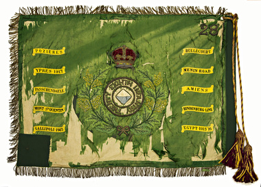
Presented by Lieutenant-General Sir JJ Talbot Hobbs, KCB, KCMG, VD, LLD at a parade held on the Esplanade, Perth, 22 October 1927. With the re-activation of the Citizen Military Forces (CMF) following the Second World War, the 11th/44th Infantry Battalion (The City of Perth Regiment) was raised as a linked battalion in 1948 to carry on the identity and traditions of the pre-war 11th and 44th Battalions respectively. The King's and Regimental Colours formerly held by these two battalions were passed on to the new battalion who paraded them in rotation on ceremonial occasions. Under major reorganisation of the CMF in 1960, all individual infantry battalions that existed at the time within each State were amalgamated to form State regiments, taking effect from 1 July 1960. Thus from that date the 11/44th, 16th and 28th Infantry Battalions were amalgamated to form The Royal Western Australia Regiment. In September 1960, at a ceremonial parade held at Northam Camp, the Colours carried by all former battalions were handed over for safe keeping by the new regiment. These former colours were subsequently laid up in the undercroft at the State War Memorial, King's Park on 29 November 1964. These were transferred to the Army Museum of WA in 1988 as part of the Bicentenary Colours Project. Dark green with gold fringes. In the centre the battalion colour patch of a white over blue oval within a circle inscribed "FORTY FOURTH INFANTRY", the whole within a wreath of Australian wattle and surmounted by the Imperial Crown. In the upper canton the Arabic numeral "44". The following battle honours are emblazoned on the Colour: SOUTH AFRICA 1899-1902, MESSINES 1917, YPRES 1917, BROODSEINDE, PASSCHENDAELE, SOMME 1918, ANCRE 1918, HAMEL, AMIENS, MONT ST QUENTIN, HINDENBURG LINE -
 Ballarat Tramway Museum
Ephemera - Timetable/s, Melbourne and Metropolitan Tramways Board (MMTB), Set of 24 MMTB Melbourne tram timetables, 1969
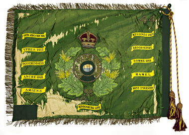
Set of 24 MMTB timetables for various routes, dated July 1969. Generally includes Sat and Suns, Good Friday and Christmas day as well as weekdays, unless noted otherwise. Also includes a map of the route, detailed time points, sections, connecting services, fares, and organisation address - 616 Little Collins St. Melbourne. Have been folded into ten portions. All on white paper unless noted otherwise. Items shown with an # - have a sticker modifying timetable information details on the front page. 1154.1 - Route 4 - Carnegie - City .2 - Route 4D - East Malvern (Darling Road) - City # .3 - Route 5 - Malvern Burk Road, - City # .4 - Route 6 - Glen Iris - City # .5 - Route 7 - Camberwell - City # .6 - Route 8 - Toorak - City # .7 - Routes 9, 10 and 12 - South Melbourne and St Kilda Beach - City (Brunswick St.) - via Collins St. .8 - Routes 10, 11 - West Preston and routes 9 & 9A Northcote .9 - Routes 15 & 22 - Moreland and 1 & 21 - East Coburg .10 - Route - 15 & 16 - St Kilda Beach and 1 & 2A - South Melbourne Beach - via Swanston St. .11 - Route 19 - North Coburg - City # .12 - Route 42 - Mont Albert - City # .13 - Routes 48 - North Balwyn and Burwood - City .14 - as above, but for Saturdays and Sundays on pink paper .15 - Routes 55 & 56, West Coburg - City - (William St.) - Domain Road. .16 - Route 57 - West Maribyrnong - City .17 - Route 59 - Essendon (Aerodrome) - City .18 - Route 64 & 65 - East Brighton - City .19 - Route 69 - Kew Cotham Road - St. Kilda Beach # .20 - Route 70 - Wattle Park - City # .21 - Routes 77 - Prahran - City, 78 - North Richmond - Prahran, 79 - North Richmond - St Kilda Beach .22 - Route 82 - Footscray to Moonee Ponds .23 - Route 88 - East Preston - City and Route 96, East Brunswick - City .24 - as above but for Saturdays and Sundays on pink paper. Images of a sample of documents added 16-11-2013.mmtb, timetables, melbourne -
 Australian Institute of Archaeology
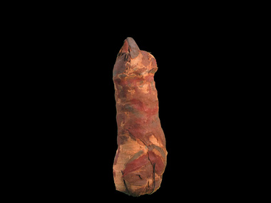
Mummified Cat, Charlie, Pre Ptolemaic - before 330BC
... Australian Institute of Archaeology Mont Park complex (near ...Neutron scans from ANSTO reveal that only portion of the animal, probably a cat, was wrapped in the mummy. Preliminary reports of C14 dating indicates that it dates from about 600BCE. It was discovered in the 1850s in Egypt. Many animals in ancient Egypt were deemed to represent a specific deity. Egyptologists have suggested that in the first millennium B.C. an act of popular piety was to place a mummified animal as a votive offering in a catacomb established at a cult center of that deity. Such an act may be expected to afford protection and bring good fortune. More recently, a close connection between the veneration of sacred animals and the worship of the king has been proposed, with the suggestion that these offerings were obligatory for religious officials and soldiers connected with certain royal cults. Interment of sacred animals was quite common in the Ptolemaic period (304-30 BCE) and continued well into the first half of the Roman period, or the second century CE. Cat cemeteries have been found throughout Egypt, and it is probably the Goddess, Bastet's association with her divine sisters in the wild, the malevolent Sakhmet and other lion-headed goddesses, that accounts for the presence of very large cat catacombs at Saqqara, Thebes, and Beni Hasan, where these leonine deities were particularly revered. There were several ways in which the cats were prepared for deposition; in the simplest cases the bodies were mummified and wrapped in linen strips, which were sometimes dyed different brown tones and woven to form geometric patterns. Usually the limbs were positioned close to the body, making a compact bundle but some mummies held lifelike poses. Egyptians considered certain individual animals to be living manifestations of a god, such as, the Apis bull. Individuals were mummified when they died and buried for eternal life, then replaced by another single living manifestation. Research on animal mummies shows that the majority of mummies found at the large animal cemetery sites are pre-adults who were purposely killed for use, sometimes by breaking the neck. Some mummies are 'substitutes' containing only a few bones or feathers or possibly sticks or sand. Mummified cat remains. -
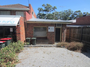
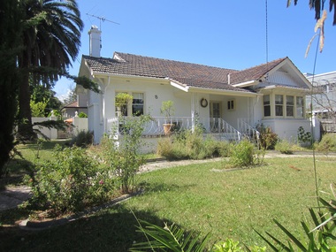
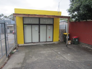
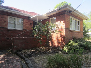
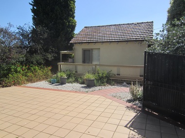
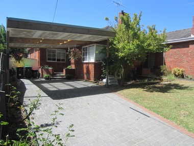
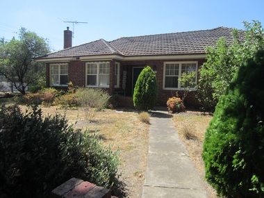
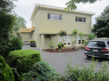
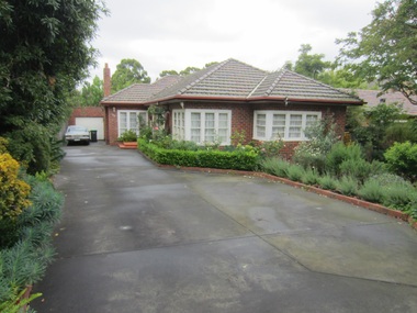
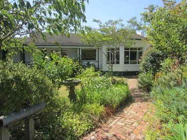
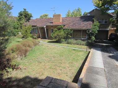
 Surrey Hills Historical Society Collection
Photograph - 1 Park Road, Surrey Hills, On The Street Where You Live Project
Photos documenting this address as part of a photographic series undertaken by volunteer photographers during 2013 and 2014 for The Street Where You Live Project. This was organised through the Surrey Hills Neighbourhood Centre and covered the postcode 3127 in the cities of Boroondara and Whitehorse.These photos provide a snapshot of real estate in the suburbs of Mont Albert and Surrey Hills during a period of rapid change with many properties on large blocks demolished to create higher density residential development or renewal of single dwellings. At particular risk were properties not covered by heritage overlays, especially interwar housing and post 1950's housing. -
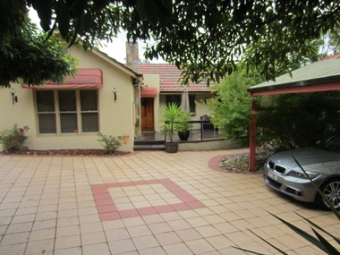
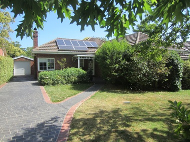
 Surrey Hills Historical Society Collection
Photograph - 2 Park Road, Surrey Hills, On The Street Where You Live Project
Photos documenting this address as part of a photographic series undertaken by volunteer photographers during 2013 and 2014 for The Street Where You Live Project. This was organised through the Surrey Hills Neighbourhood Centre and covered the postcode 3127 in the cities of Boroondara and Whitehorse.These photos provide a snapshot of real estate in the suburbs of Mont Albert and Surrey Hills during a period of rapid change with many properties on large blocks demolished to create higher density residential development or renewal of single dwellings. At particular risk were properties not covered by heritage overlays, especially interwar housing and post 1950's housing. -
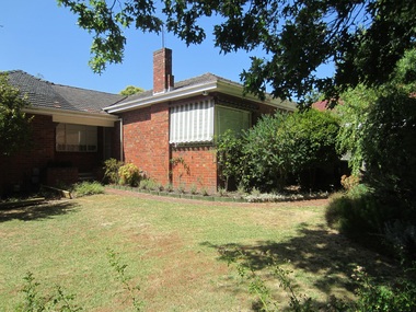
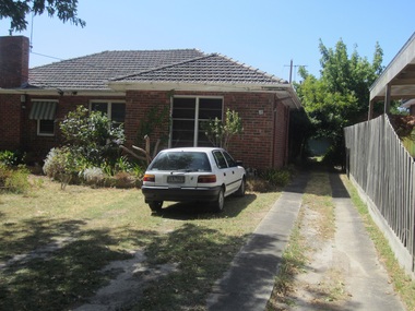
 Surrey Hills Historical Society Collection
Photograph - 5 Park Road, Surrey Hills, On The Street Where You Live Project
Photos documenting this address as part of a photographic series undertaken by volunteer photographers during 2013 and 2014 for The Street Where You Live Project. This was organised through the Surrey Hills Neighbourhood Centre and covered the postcode 3127 in the cities of Boroondara and Whitehorse.These photos provide a snapshot of real estate in the suburbs of Mont Albert and Surrey Hills during a period of rapid change with many properties on large blocks demolished to create higher density residential development or renewal of single dwellings. At particular risk were properties not covered by heritage overlays, especially interwar housing and post 1950's housing. -
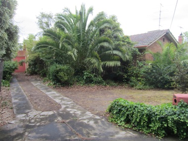
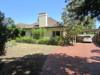
 Surrey Hills Historical Society Collection
Photograph - 6 Park Road, Surrey Hills, On The Street Where You Live Project
Photos documenting this address as part of a photographic series undertaken by volunteer photographers during 2013 and 2014 for The Street Where You Live Project. This was organised through the Surrey Hills Neighbourhood Centre and covered the postcode 3127 in the cities of Boroondara and Whitehorse.These photos provide a snapshot of real estate in the suburbs of Mont Albert and Surrey Hills during a period of rapid change with many properties on large blocks demolished to create higher density residential development or renewal of single dwellings. At particular risk were properties not covered by heritage overlays, especially interwar housing and post 1950's housing. -
 Surrey Hills Historical Society Collection
Photograph - 7 Park Road, Surrey Hills, On The Street Where You Live Project
Photos documenting this address as part of a photographic series undertaken by volunteer photographers during 2013 and 2014 for The Street Where You Live Project. This was organised through the Surrey Hills Neighbourhood Centre and covered the postcode 3127 in the cities of Boroondara and Whitehorse.These photos provide a snapshot of real estate in the suburbs of Mont Albert and Surrey Hills during a period of rapid change with many properties on large blocks demolished to create higher density residential development or renewal of single dwellings. At particular risk were properties not covered by heritage overlays, especially interwar housing and post 1950's housing. -
 Surrey Hills Historical Society Collection
Photograph - 8 Park Road, Surrey Hills, On The Street Where You Live Project
Photos documenting this address as part of a photographic series undertaken by volunteer photographers during 2013 and 2014 for The Street Where You Live Project. This was organised through the Surrey Hills Neighbourhood Centre and covered the postcode 3127 in the cities of Boroondara and Whitehorse.These photos provide a snapshot of real estate in the suburbs of Mont Albert and Surrey Hills during a period of rapid change with many properties on large blocks demolished to create higher density residential development or renewal of single dwellings. At particular risk were properties not covered by heritage overlays, especially interwar housing and post 1950's housing. -
 Surrey Hills Historical Society Collection
Photograph - 11 Park Road, Surrey Hills, On The Street Where You Live Project
Photos documenting this address as part of a photographic series undertaken by volunteer photographers during 2013 and 2014 for The Street Where You Live Project. This was organised through the Surrey Hills Neighbourhood Centre and covered the postcode 3127 in the cities of Boroondara and Whitehorse.These photos provide a snapshot of real estate in the suburbs of Mont Albert and Surrey Hills during a period of rapid change with many properties on large blocks demolished to create higher density residential development or renewal of single dwellings. At particular risk were properties not covered by heritage overlays, especially interwar housing and post 1950's housing. -
 Surrey Hills Historical Society Collection
Photograph - 12 Park Road, Surrey Hills, On The Street Where You Live Project
Photos documenting this address as part of a photographic series undertaken by volunteer photographers during 2013 and 2014 for The Street Where You Live Project. This was organised through the Surrey Hills Neighbourhood Centre and covered the postcode 3127 in the cities of Boroondara and Whitehorse.These photos provide a snapshot of real estate in the suburbs of Mont Albert and Surrey Hills during a period of rapid change with many properties on large blocks demolished to create higher density residential development or renewal of single dwellings. At particular risk were properties not covered by heritage overlays, especially interwar housing and post 1950's housing. -
 Surrey Hills Historical Society Collection
Photograph - 13 Park Road, Surrey Hills, On The Street Where You Live Project
Photos documenting this address as part of a photographic series undertaken by volunteer photographers during 2013 and 2014 for The Street Where You Live Project. This was organised through the Surrey Hills Neighbourhood Centre and covered the postcode 3127 in the cities of Boroondara and Whitehorse.These photos provide a snapshot of real estate in the suburbs of Mont Albert and Surrey Hills during a period of rapid change with many properties on large blocks demolished to create higher density residential development or renewal of single dwellings. At particular risk were properties not covered by heritage overlays, especially interwar housing and post 1950's housing. -
 Surrey Hills Historical Society Collection
Photograph - 13A Park Road, Surrey Hills, On The Street Where You Live Project
Photos documenting this address as part of a photographic series undertaken by volunteer photographers during 2013 and 2014 for The Street Where You Live Project. This was organised through the Surrey Hills Neighbourhood Centre and covered the postcode 3127 in the cities of Boroondara and Whitehorse.These photos provide a snapshot of real estate in the suburbs of Mont Albert and Surrey Hills during a period of rapid change with many properties on large blocks demolished to create higher density residential development or renewal of single dwellings. At particular risk were properties not covered by heritage overlays, especially interwar housing and post 1950's housing. -
 Surrey Hills Historical Society Collection
Photograph - 14 Park Road, Surrey Hills, On The Street Where You Live Project
Photos documenting this address as part of a photographic series undertaken by volunteer photographers during 2013 and 2014 for The Street Where You Live Project. This was organised through the Surrey Hills Neighbourhood Centre and covered the postcode 3127 in the cities of Boroondara and Whitehorse.These photos provide a snapshot of real estate in the suburbs of Mont Albert and Surrey Hills during a period of rapid change with many properties on large blocks demolished to create higher density residential development or renewal of single dwellings. At particular risk were properties not covered by heritage overlays, especially interwar housing and post 1950's housing. -
 Surrey Hills Historical Society Collection
Photograph - 15 Park Road, Surrey Hills, On The Street Where You Live Project
Photos documenting this address as part of a photographic series undertaken by volunteer photographers during 2013 and 2014 for The Street Where You Live Project. This was organised through the Surrey Hills Neighbourhood Centre and covered the postcode 3127 in the cities of Boroondara and Whitehorse.These photos provide a snapshot of real estate in the suburbs of Mont Albert and Surrey Hills during a period of rapid change with many properties on large blocks demolished to create higher density residential development or renewal of single dwellings. At particular risk were properties not covered by heritage overlays, especially interwar housing and post 1950's housing. -
 Surrey Hills Historical Society Collection
Photograph - 16 Park Road, Surrey Hills, On The Street Where You Live Project
Photos documenting this address as part of a photographic series undertaken by volunteer photographers during 2013 and 2014 for The Street Where You Live Project. This was organised through the Surrey Hills Neighbourhood Centre and covered the postcode 3127 in the cities of Boroondara and Whitehorse.These photos provide a snapshot of real estate in the suburbs of Mont Albert and Surrey Hills during a period of rapid change with many properties on large blocks demolished to create higher density residential development or renewal of single dwellings. At particular risk were properties not covered by heritage overlays, especially interwar housing and post 1950's housing. -
 Surrey Hills Historical Society Collection
Photograph - 17 Park Road, Surrey Hills, On The Street Where You Live Project
Photos documenting this address as part of a photographic series undertaken by volunteer photographers during 2013 and 2014 for The Street Where You Live Project. This was organised through the Surrey Hills Neighbourhood Centre and covered the postcode 3127 in the cities of Boroondara and Whitehorse.These photos provide a snapshot of real estate in the suburbs of Mont Albert and Surrey Hills during a period of rapid change with many properties on large blocks demolished to create higher density residential development or renewal of single dwellings. At particular risk were properties not covered by heritage overlays, especially interwar housing and post 1950's housing. -
 Surrey Hills Historical Society Collection
Photograph - 18 Park Road, Surrey Hills, On The Street Where You Live Project
Photos documenting this address as part of a photographic series undertaken by volunteer photographers during 2013 and 2014 for The Street Where You Live Project. This was organised through the Surrey Hills Neighbourhood Centre and covered the postcode 3127 in the cities of Boroondara and Whitehorse.These photos provide a snapshot of real estate in the suburbs of Mont Albert and Surrey Hills during a period of rapid change with many properties on large blocks demolished to create higher density residential development or renewal of single dwellings. At particular risk were properties not covered by heritage overlays, especially interwar housing and post 1950's housing. -
 Surrey Hills Historical Society Collection
Photograph - 19 Park Road, Surrey Hills, On The Street Where You Live Project
Photos documenting this address as part of a photographic series undertaken by volunteer photographers during 2013 and 2014 for The Street Where You Live Project. This was organised through the Surrey Hills Neighbourhood Centre and covered the postcode 3127 in the cities of Boroondara and Whitehorse.These photos provide a snapshot of real estate in the suburbs of Mont Albert and Surrey Hills during a period of rapid change with many properties on large blocks demolished to create higher density residential development or renewal of single dwellings. At particular risk were properties not covered by heritage overlays, especially interwar housing and post 1950's housing. -
 Surrey Hills Historical Society Collection
Photograph - 20 Park Road, Surrey Hills, On The Street Where You Live Project
Photos documenting this address as part of a photographic series undertaken by volunteer photographers during 2013 and 2014 for The Street Where You Live Project. This was organised through the Surrey Hills Neighbourhood Centre and covered the postcode 3127 in the cities of Boroondara and Whitehorse.These photos provide a snapshot of real estate in the suburbs of Mont Albert and Surrey Hills during a period of rapid change with many properties on large blocks demolished to create higher density residential development or renewal of single dwellings. At particular risk were properties not covered by heritage overlays, especially interwar housing and post 1950's housing. -
 Surrey Hills Historical Society Collection
Photograph - 21 Park Road, Surrey Hills, On The Street Where You Live Project
Photos documenting this address as part of a photographic series undertaken by volunteer photographers during 2013 and 2014 for The Street Where You Live Project. This was organised through the Surrey Hills Neighbourhood Centre and covered the postcode 3127 in the cities of Boroondara and Whitehorse.These photos provide a snapshot of real estate in the suburbs of Mont Albert and Surrey Hills during a period of rapid change with many properties on large blocks demolished to create higher density residential development or renewal of single dwellings. At particular risk were properties not covered by heritage overlays, especially interwar housing and post 1950's housing. -
 Surrey Hills Historical Society Collection
Photograph - 23 Park Road, Surrey Hills, On The Street Where You Live Project
Photos documenting this address as part of a photographic series undertaken by volunteer photographers during 2013 and 2014 for The Street Where You Live Project. This was organised through the Surrey Hills Neighbourhood Centre and covered the postcode 3127 in the cities of Boroondara and Whitehorse.These photos provide a snapshot of real estate in the suburbs of Mont Albert and Surrey Hills during a period of rapid change with many properties on large blocks demolished to create higher density residential development or renewal of single dwellings. At particular risk were properties not covered by heritage overlays, especially interwar housing and post 1950's housing. -
 Surrey Hills Historical Society Collection
Photograph - 24 Park Road, Surrey Hills, On The Street Where You Live Project
Photos documenting this address as part of a photographic series undertaken by volunteer photographers during 2013 and 2014 for The Street Where You Live Project. This was organised through the Surrey Hills Neighbourhood Centre and covered the postcode 3127 in the cities of Boroondara and Whitehorse.These photos provide a snapshot of real estate in the suburbs of Mont Albert and Surrey Hills during a period of rapid change with many properties on large blocks demolished to create higher density residential development or renewal of single dwellings. At particular risk were properties not covered by heritage overlays, especially interwar housing and post 1950's housing. -
 Surrey Hills Historical Society Collection
Photograph - 25 Park Road, Surrey Hills, On The Street Where You Live Project
Photos documenting this address as part of a photographic series undertaken by volunteer photographers during 2013 and 2014 for The Street Where You Live Project. This was organised through the Surrey Hills Neighbourhood Centre and covered the postcode 3127 in the cities of Boroondara and Whitehorse.These photos provide a snapshot of real estate in the suburbs of Mont Albert and Surrey Hills during a period of rapid change with many properties on large blocks demolished to create higher density residential development or renewal of single dwellings. At particular risk were properties not covered by heritage overlays, especially interwar housing and post 1950's housing.