Showing 434 items matching "nepean"
-
 Greensborough Historical Society
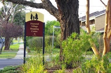
Photograph - Digital image, Marilyn Smith, Diamond Village Shopping Centre (Sign), Watsonia, 2016, 22/05/2016
Diamond Village Shopping Centre (Sign), Nepean Street Watsonia.Digital copy of colour photograph.diamond village shopping centre, watsonia -
 Greensborough Historical Society
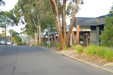
Photograph - Digital image, Marilyn Smith, Diamond Village Shopping Centre (Exterior 1), Watsonia, 2016, 22/05/2016
Diamond Village Shopping Centre (Exterior), Nepean Street Watsonia.Digital copy of colour photograph.diamond village shopping centre, watsonia -
 Greensborough Historical Society
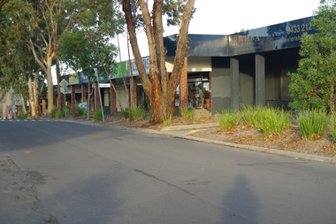
Photograph - Digital image, Marilyn Smith, Diamond Village Shopping Centre (Exterior 2), Watsonia, 2016, 22/05/2016
Diamond Village Shopping Centre (Exterior), Nepean Street Watsonia.Digital copy of colour photograph.diamond village shopping centre, watsonia -
 Greensborough Historical Society
Photograph - Digital image, Marilyn Smith, Diamond Village Shopping Centre (Exterior 3), Watsonia, 2016, 22/05/2016
Diamond Village Shopping Centre (Exterior), Nepean Street Watsonia.Digital copy of colour photograph.diamond village shopping centre, watsonia -
 Greensborough Historical Society
Photograph - Digital image, Marilyn Smith, Diamond Village Shopping Centre (Exterior 4), Watsonia, 2016, 22/05/2016
Diamond Village Shopping Centre (Exterior), Nepean Street Watsonia.Digital copy of colour photograph.diamond village shopping centre, watsonia -
 Queenscliffe Maritime Museum
Functional object - Porthole
SS Cheviot was wrecked on Cheviot Beach, Sorrento, Point Nepean Salvaged from the wreck of the SS Cheviot wrecked on 20 October 1887 with loss of life. Queenscliff Lifeboat unable to navigate the Rip due to treacherous weather2 Brass Portholes -
Whitehorse Historical Society Inc.
Document, Commonwealth of Australia, 1973
Officer Cadet School ordinary permit to use defence road and the area of the Point Nepean Defence Reserve for the purpose of sightseeing issued to Nunawading Historical Society for 16 Sep 1973.Officer Cadet School ordinary permit to use defence road and the area of the Point Nepean Defence Reserve for the purpose of sightseeing issued to Nunawading Historical Society for 16 Sep 1973.Officer Cadet School ordinary permit to use defence road and the area of the Point Nepean Defence Reserve for the purpose of sightseeing issued to Nunawading Historical Society for 16 Sep 1973.armed forces, officer cadet school, portsea, australian government -
 City of Kingston
Pamphlet - Colour, Highett Town, 1888
Sales plan for land in the suburb of Highett, bounded by Highett Road, Worthing Terrace and the railway line, and incorporating Major Street and Train Street.The developing urban area of Highett within the City of Kingston. This land sale pamphlet illustrates the subdivision of land within the municipality and the changing demographic of the district as new houses are constructed close to infrastructure.Colour pamphlet advertising for private sale the Station Entrance Estate, Highett. Incorporates a map of the estate bordered by Wickham Road, Railway Parade, Highett Road and Point Nepean Road.land sales, highett -
 Greensborough Historical Society
Photograph - Digital image, Marilyn Smith, Hair Headquarters, Watsonia, 2016, 22/05/2016
Hair Headquarters at Diamond Village Shopping Centre, Nepean Street Watsonia.Digital copy of colour photograph.diamond village shopping centre, watsonia, hair headquarters -
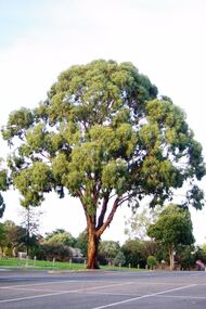 Greensborough Historical Society
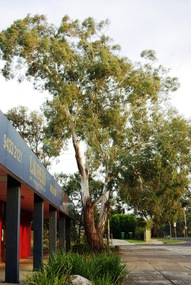
Photograph - Digital image, Marilyn Smith, Diamond Village Shopping Centre (Trees in Carpark), Watsonia, 2016, 22/05/2016
Diamond Village Shopping Centre (Trees in Carpark), Nepean Street Watsonia.Digital copy of colour photograph.diamond village shopping centre, watsonia -
 City of Kingston
Pamphlet - Colour, H. R. Hill & Co, Walker's Estate, Cheltenham for sale by public auction, c. 1923
Sales plan for land in the suburb of Cheltenham, encompassing both sides of Walker Grove, a section of Centre Dandenong Rd and Axelton St. The developing urban area of Cheltenham within the City of Kingston. This land sale pamphlet illustrates the subdivision of land within the municipality and the changing demographic of the district as new houses are constructed.Black and white pamphlet advertising for private sale the Station Entrance Estate, Highett. Incorporates a map of the estate bordered by Wickham Road, Railway Parade, Highett Road and Point Nepean Road.Handwritten in black pen on subdivision map: 'x' written on subdivisions 2, 3, 8-11, 15-17, 19. Potentially indicating that these properties did not sell at auction. Handwritten in black pen on subdivision map: assumed sale price on subdivisions 1, 4-7, 12-14, 18, 20-31. land sales, cheltenham, estate -
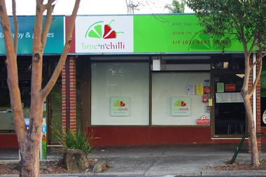 Greensborough Historical Society
Photograph - Digital image, Marilyn Smith, LimeNChilli, Watsonia, 2016, 22/05/2016
LimeNChilli (Thai Restaurant) at Diamond Village Shopping Centre, Nepean Street Watsonia.Digital copy of colour photograph.diamond village shopping centre, watsonia, limenchilli -
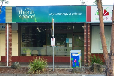 Greensborough Historical Society
Photograph - Digital image, Marilyn Smith, Theraspace, Watsonia, 2016, 22/05/2016
Theraspace Physiotherapy and Pilates at Diamond Village Shopping Centre, Nepean Street Watsonia.Digital copy of colour photograph.diamond village shopping centre, watsonia, theraspace -
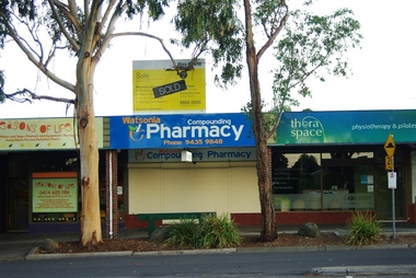 Greensborough Historical Society
Photograph - Digital image, Marilyn Smith, Watsonia Compounding Pharmacy, Watsonia, 2016, 22/05/2016
Watsonia Compounding Pharmacy at Diamond Village Shopping Centre, Nepean Street Watsonia.Digital copy of colour photograph.diamond village shopping centre, watsonia, watsonia compounding pharmacy -
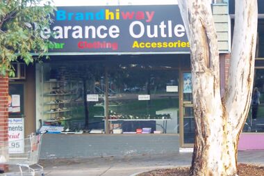 Greensborough Historical Society
Photograph - Digital image, Marilyn Smith, Brands Hiway, Watsonia, 2016, 22/05/2016
BrandsHiway (children's shoes) at Diamond Village Shopping Centre, Nepean Street Watsonia.Digital copy of colour photograph.diamond village shopping centre, watsonia, brands hiway -
 Greensborough Historical Society
Photograph - Digital image, Marilyn Smith, Diamond Village Newsagent, Watsonia, 2016, 22/05/2016
Diamond Village Newsagent at Diamond Village Shopping Centre, Nepean Street Watsonia.Digital copy of colour photograph.diamond village shopping centre, watsonia, diamond village newsagent -
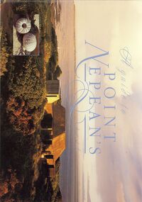 Bendigo Historical Society Inc.
Book - STRAUCH COLLECTION: A GUIDE TO POINT NEPEANS PAST
BHS CollectionA guide to Point Nepean's past by Harry Breidahl published by the Victorian Department of Conversation and Environment in association with Nautilus Educational Pty Ltd, 32 pages with photographs, illustrations & maps in black and white & colour.Harry Breidahlvictoria, history, nepean peninsula, victoria-history-point nepean -
 Greensborough Historical Society
Business card, Hair Headquarters 2018, 2018_
Business card for a local hairdresser, Hair Headquarters, at 78-92 Nepean Street Watsonia.Business card, brown card with white text.hair headquarters, nepean street watsonia, diamond village shopping centre -
 Greensborough Historical Society
Photograph - Digital image, Marilyn Smith, Cruze Lounge, Diamond Village Shopping Centre 2016, 22/05/2016
Cruze Lounge (coffee cafe) at Diamond Village Shopping Centre, Nepean Street Watsonia.Digital copy of colour photograph.cruze lounge, diamond village shopping centre -
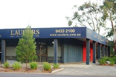 Greensborough Historical Society
Photograph - Digital image, Marilyn Smith, Lauders Real Estate Watsonia, Diamond Village Shopping Centre 2016, 22/05/2016
Lauders Real Estate Watsonia at Diamond Village Shopping Centre, Nepean Street Watsonia.Digital copy of colour photograph.diamond village shopping centre, lauders real estate, watsonia -
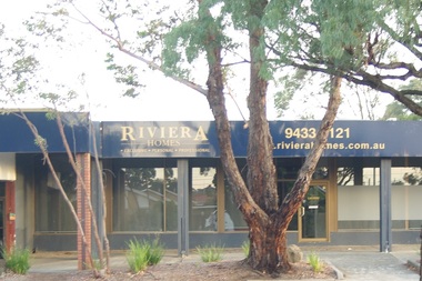 Greensborough Historical Society
Photograph - Digital image, Marilyn Smith, Riviera Homes Pty Ltd, Watsonia, 2016, 22/05/2016
Riviera Homes Pty Ltd at Diamond Village Shopping Centre, Nepean Street Watsonia.Digital copy of colour photograph.diamond village shopping centre, watsonia, riviera homes -
 Greensborough Historical Society
Photograph - Digital image, Marilyn Smith, Diamond Village Pizza and Pasta, Watsonia, 2016, 22/05/2016
Diamond Village Pizza and Pasta at Diamond Village Shopping Centre, Nepean Street Watsonia.Digital copy of colour photograph.diamond village shopping centre, watsonia, diamond village pizza and pasta -
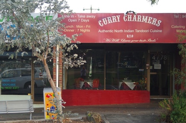 Greensborough Historical Society
Photograph - Digital image, Marilyn Smith, Curry Charmers, Watsonia, 2016, 22/05/2016
Curry Charmers (Indian restaurant) at Diamond Village Shopping Centre, Nepean Street Watsonia.Digital copy of colour photograph.diamond village shopping centre, watsonia, curry charmers -
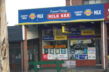 Greensborough Historical Society
Photograph - Digital image, Marilyn Smith, Diamond Village Milk Bar, Watsonia, 2016, 22/05/2016
Diamond Village Milk Bar at Diamond Village Shopping Centre, Nepean Street Watsonia.Digital copy of colour photograph.diamond village shopping centre, watsonia, diamond village milk bar -
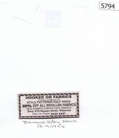 Greensborough Historical Society
Newspaper Clipping, Diamond Valley News, Hooked on Fabrics Greensborough, 13/09/1995
An advertisement for Hooked on Fabrics, Shop3/78 Nepean Street Watsonia, (formerly of Beewar Street, Greensborough) Newspaper clipping, black and white text.hooked on fabrics, nepean street watsonia, beewar street greensborough -
City of Moorabbin Historical Society (Operating the Box Cottage Museum)
Pamphlet - St Finbar's Parish Church, East Brighton - Celebrating 150 Years 1848-1998, 1998
St Finbar's Roman Catholic Church corner of Nepean Highway and Centre Road, East Brighton.St Finbar's Roman Catholic Church East Brighton was erected in 1871 and was integral to the spiritual well being and social life of the early settlers.Four page AO5 brochure inviting people to join in historic 150 year celebration. Contains brief history of the Parish of St Finger's East Brighton.early settlers, parish of moorabbin, city of moorabbin, county of bourke, shire of moorabbin, were j.b., market gardeners, nepean highway, east brighton, st finbar's parish, centre road, religion, roman catholic -
 City of Kingston
Negative - Colour, 1926
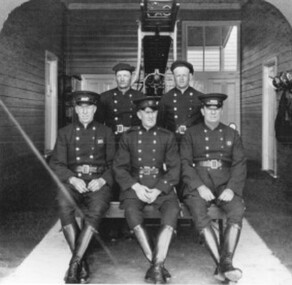
Until 1911 Cheltenham had a local Voluntary Fire Brigade. In that year the Metropolitan Fire Brigade was formed and through it a hall was built on the Highway at a cost of £350. Eight years later a brick house costing £1151 was added. There were two full time firemen; several others served part time. In 1960 the fire protection system was re-organised; the building on the Highway was demolished and replaced by the Ambulance Station.Two images on one strip of negative film. The first image is a black and white image of five firefighters pictured inside Cheltenham Fire Station, Nepean Highway. The second image is of the firefighting truck at the station. -
 City of Kingston
Photograph - Black and white, 20 December 1945
This aerial photograph depicts the changing landscape of Cheltenham and Highett since WWII. Photographed in 1945, there is a mix of urban dwellings and industrial development and precedes the major transformation of Cheltenham with the development of the Southland shopping centre in the 1960s and expansion in the 1990s.A large part of Cheltenham was originally established as a rural market gardening community. The railway line and station brought urban development to the area and in the north, the Highett area was dominated by the Highett Gas Works. Cheltenham became a major destination for shopping in the 1960s with the opening of Southland.Aerial photograph taken in 1945 of Cheltenham and Highett within the City of Kingston. The image includes the Highett Reserve, (top right), the Methodist Children Homes (now Southland), Nepean Highway and Jamieson Street. Highett Gas Works is visible in the top left and the land now named William Fry Reserve at the intersection of Bay Road and Nepean Highway. A visible large parcel of land on the corner of Bay Road and Nepean Highway was developed in the 1990s as the west side addition to Southland. The densely vegetated area in the upper right sector of the image is now dense with housing. Tulip Grove, Heather Grove and Gilford Street are visible bottom left. This image is possibly from the collection of aerial photographs commissioned by the Department of Crown Lands and Survey and taken by Adastra Airways.Black ink: 57252 White lettering: VIC-10 57252 20.12.45 [lens information indecipherable] PROJ. No.5 MELB. METROP AREA Black pencil: 80highett, cheltenham, highett gas works, urbanisation -
 City of Kingston
Photograph - Black and white, 20 December 1945
This aerial photograph depicts the changing landscape of Cheltenham and Highett since WWII. Photographed in 1945, there is a mix of urban dwellings and industrial development and precedes the major transformation of Cheltenham with the development of the Southland shopping centre in the 1960s and expansion in the 1990s.A large part of Cheltenham was originally established as a rural market gardening community. The railway line and station brought urban development to the area and in the north, the Highett area was dominated by the Highett Gas Works. Cheltenham became a major destination for shopping in the 1960s with the opening of Southland.Aerial photograph taken in 1945 of Cheltenham and Highett within the City of Kingston. The image includes the Highett Reserve, (top right), the Methodist Children Homes (now Southland), Nepean Highway and Jamieson Street. Highett Gas Works is visible in the top left and the land now named William Fry Reserve at the intersection of Bay Road and Nepean Highway. A visible large parcel of land on the corner of Bay Road and Nepean Highway was developed in the 1990s as the west side addition to Southland. The densely vegetated area in the upper right sector of the image is now dense with housing. Tulip Grove, Heather Grove and Gilford Street are visible bottom left. This image is possibly from the collection of aerial photographs commissioned by the Department of Crown Lands and Survey and taken by Adastra Airways.Black type: Reverse lettering VIC-10 57252 20.12.45 [lens information indecipherable] PROJ. No.5 MELB. METROP AREA White lettering: Reverse writing 57252cheltenham, highett, highett gas works, urbanisation -
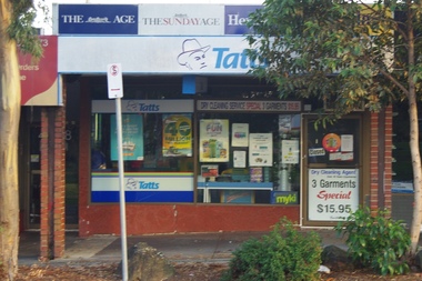
 Greensborough Historical Society
Business card, Diamond Village Lotto, Cards and News 2018, 2018_
Business card for a local newsagent, Diamond Village Lotto, Cards and News, at 78 Nepean Street Watsonia.Business card, white card with multi coloured text.nepean street watsonia, diamond village shopping centre, diamond village lotto, cards and news