Showing 891 items
matching network
-
 Glenelg Shire Council Cultural Collection
Photograph - Photograph, n.d
Port of Portland Authority Archivesport of portland archives -
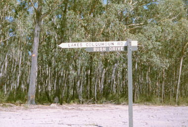 Lakes Entrance Historical Society
Photograph, Jan McDougall, 1999
Also three other photographs of road and signage in Colquhoun Forest.Colour photograph of the bush drive and signage in the vicinity of the old Colquhoun Road, once part it the road network from Lakes Entrance to Bruthen, branching to Nowa Nowa. East Gippsland Victoriahouses, parks, heritage study -
Glenelg Shire Council Cultural Collection
Container - Reusable Drink Bottle, n.d
Plastic coated aluminium drink bottle. Green, black screw top, black print and logs. Glenelg Shire Council and Portland District Health 'Get a taste of this' 'Glenelg Healthy Schools Network'glenelg shire council, community health, drink bottle -
Port Melbourne Historical & Preservation Society
Archive, Social Justice in the City, 1987 - 1988
File kept by Pat GRAINGER, a participant in the project, 1987/88Light grey binder containing documents related to the 1987 joint Community Arts Network and CURA. 'Social Justice in the City' project which funded local artists' statements against the Sandridge City development.quite a few notations on many of the itemspublic action campaigns, town planning - proposals shelved - bayside, ewan ogilvy, martin brennan, mark grant, pat grainger, kate shaw, richard crawley, maree menzel, barry merat, cura -
Lakes Entrance Historical Society
Photograph, Snowy River Mail, 1/04/2013 12:00:00 AM
Colour photograph of East Gippsland Heritage Network members Ian Hollingsworth, Marie Fish, Judy Gray, Judy Davies, Marie Tanner, Janet Palmer at Orbost Historical Society exhibition Orbost Victoriafishing industry, maritime history -
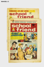 Whitehorse Historical Society Inc.
Magazine, 1962
Donated by the Eastern Emergency Network'School Friend' girls' magazine printed weekly and sold for 5 pence each. External covers are printed in colour, all internal pages are printed in black and white.A Modern School's Favouritedocuments, education -
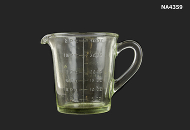 Whitehorse Historical Society Inc.
Domestic object - Jug, 1930 - 1940
Collected from Eastern Emergency NetworkHeavy glass measuring jug with imperial measures from two pints to 40 ounces.1/4 PT - 2 PT; 5 OZ - 40 OZdomestic items, cooking, glass technology, bottles -
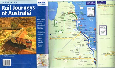 Melbourne Tram Museum
Map, HEMA Maps, "Rail Journeys of Australia", 2011
Map - 16 fold full colour gloss paper titled "Rail Journeys of Australia", published 2011m diagrammatic maps of the Australian rail network, complete suburban rail and tram networks, heritage railways, railway museums and miniature railways. Has a photo of The Ghan on the front. Published by HEMA Maps. Includes a combined diagrammatic map of Melbourne suburban railway and tramways and ferries. Has a note on the frequency and fares. Received during 2011 as a with compliments slip and asking if needed more. Slip gives the publishers details.trams, tramways, maps, australian railways, trams, melbourne -
 Bacchus Marsh & District Historical Society
Map, Gorrockburkchap Parish Map, County of Grant c.1915
The parish of Gorrockburkchap (sometimes spelled Gorrockburkghap) lies to the west and south west of the township of Bacchus Marsh. The locality of Rowsley is situated within this parish area.A single page paper map showing the parish plan for Gorrockburkchap in the County of Grant. The map is pasted into a bound volume containing 76 maps or plans in total. High resolution digital image stored on BMDHS computer network. gorrockburkchap parish maps, rowsley victoria maps -
 Bacchus Marsh & District Historical Society
Map, Gorrockburkchap Parish Map, County of Grant
The parish of Gorrockburkchap (sometimes spelled Gorrockburkghap) lies to the west and south west of the township of Bacchus Marsh. The locality of Rowsley is situated within this parish area.A single page paper map showing the parish plan for Gorrockburkchap in the County of Grant. The map is pasted into a bound volume containing 76 maps or plans in total. High resolution digital image stored on BMDHS computer network. gorrockburkchap parish maps, rowsley victoria maps -
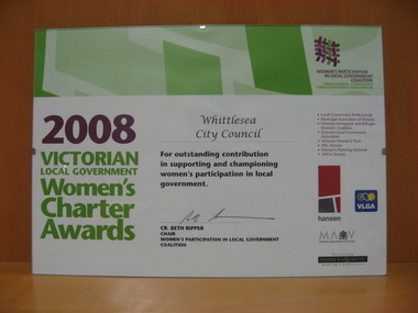 City of Whittlesea
Award (item) - Council Awards, Victorian Local Government Women's Charter Awards
Women's Participation in Local Government Coalition Strengthening Communities Through Women’s Participation 2008 Victorian Local Government Women’s Charter Awards Whittlesea City Council For outstanding contribution in supporting and championing women’s participation in local government CR. Beth Ripper Chair Women’s Participation in Local Government Coalition Local Government Professionals Municipal Association of Victoria Victorian Immigrant and Refugee Women’s Coalition Victorian Local Governance Association Victorian Women’s Trust WEL Victoria Women’s Planning Network YWCA Victoria hansen VLGA Municipal Association Of Victoria Victorian Women’s’ Trust making a differenceWomen's Participation in Local Government Coalition Strengthening Communities Through Women’s Participation 2008 Victorian Local Government Women’s Charter Awards Whittlesea City Council For outstanding contribution in supporting and championing women’s participation in local government CR. Beth Ripper Chair Women’s Participation in Local Government Coalition Local Government Professionals Municipal Association of Victoria Victorian Immigrant and Refugee Women’s Coalition Victorian Local Governance Association Victorian Women’s Trust WEL Victoria Women’s Planning Network YWCA Victoria hansen VLGA Municipal Association Of Victoria Victorian Women’s’ Trust making a differenceawards -
 Bacchus Marsh & District Historical Society
Map, Plan of part of the road district of Bacchus Marsh circa 1856-1862
Local government in much of Victoria including the Bacchus Marsh area began with the formation of 'local committees'. These local committees could make representations to a Central Road Board regarding plans for road construction. Road construction and maintenance were seen as the essential tasks of these early local government authorities. By 1856 the local committee in Bacchus Marsh was constituted as the Bacchus Marsh Road District. This entity continued until 1862 when the name changed to the Bacchus Marsh and Maddingley Road District. This new entity lasted until 1871 when the local government authority in accordance with new statewide legislation became known as the Shire of Bacchus Marsh. The title of this plan being a plan of 'a portion of the road district of Bacchus Marsh' suggests that the plan was produced sometime between 1856 and 1862. The main purpose of this map was to shown the irrigable land in the district and the sources from which water for irrigation could be drawn. Bacchus Marsh was an early irrigation district in Victoria. Irrigation trusts were formed in the 1880s and 1890s to manage irrigation districts. But this was the culmination of many years of earlier attempts to construct irrigation systems in the Bacchus Marsh area and create a system to manage irrigation more broadly. This map dating from around 1856-1862 is an important cartographic document which provides evidence of how the early planning for irrigation was developing in the Bacchus Marsh region.A single page paper map showing a plan of part of the road district of Bacchus Marsh. The map is pasted into a bound volume containing 76 maps or plans in total. High resolution digital image stored on BMDHS computer network. bacchus marsh victoria maps, bacchus marsh road district, local government, road districts, irrigation -
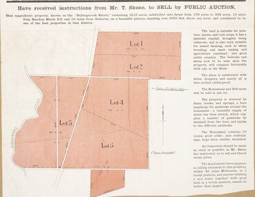 Bacchus Marsh & District Historical Society
Map, Bullengarook Estate Property Sale. 1911
Bullengarook is a locality located 19 kilometers north of Bacchus Marsh. Pastoral leases for European colonists were granted to people for this area from around the 1840s.The Bullengarook Estate was part of these early pastoral holdings. By the 1900s the property had been owned by the Skene family for a number of years. In early 1911 the property then consisting of 300 acres and the homestead upon it was offered for sale in one lot. It appears however that the sale of the property did not go through in 1911. It was later leased by Thomas Skene to a Mr Coutts in 1915 and ultimately and at a later stage the property was sold by the Skene family.A single page paper map showing land allotments for sale from the Bullengarook Estate. The map is pasted into a bound volume containing 76 maps or plans in total. High resolution digital image stored on BMDHS computer network. land sales bacchus marsh, bullengarook land sales, bullengarook estate, bullengarook vic history -
 Greensborough Historical Society
Pamphlet, Bus Association Victoria, Melbourne @ your fingertips: Melbourne's city and Northern suburbs, 2010s
An explanation of Melbourne's bus network in the city and Northern suburbs.Colour leaflet, double-sided, 6 p., map.public transport, buses -
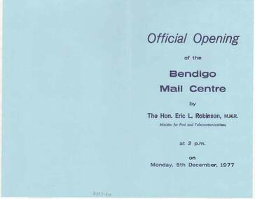 Bendigo Historical Society Inc.
Document - DOCUMENT - OFFICIAL OPENING OF THE BENDIGO MAIL CENTRE, 05/12/1977
The Victorian Mail Network brochures, two with Official Opening of the Bendigo Mail Centre Programs. The Opening took place on Monday, 5th December, 1977.In the program are some Postal Historical notes and the program for the day. The brochure Victorian Mail Network has a map of the postal districts of Victoria with Country and Metropolitan Mail Centres and some notes on the front. On the inside, is another map from Kyneton - Echuca, Robinvale, Wentworth, Ouyen and to Bendigo via Charlton. Also Castlemaine. It has a list of the Benefits of the Scheme. On the back is a table, Standard of Service - Final posting times.bendigo, institutions, bendigo post office, document, official opening of the bendigo mail centre, the hon. eric l. robinson, m.h.r., joseph cusworth, sir john nimmo, john w henderson, r j page, cr r f turner, c g primmer, j w bourchier, b coughlan -
 Whitehorse Historical Society Inc.
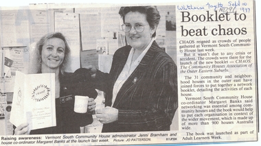
Newspaper, Booklet to beat chaos, 1/09/1997 12:00:00 AM
The 31 Community and Neighbourhood Houses in the Outer East have joined forces to put together a network booklet detailing the activities of each house.Cutting from 'Whitehorse Gazette, 10/9/97 re launch of the new booklet 'Chaos', the Community Houses Association of the Outer Eastern Suburbs. The 31 Community and Neighbourhood Houses in the Outer East have joined forces to put together a network booklet detailing the activities of each house. Margaret Banks, co-ordinator, Vermont South Community House said networking was essential among Community houses and the booklet would help to put each organisation in the context of the wider movement which is made up of more than 900 houses Australia wide.The 31 Community and Neighbourhood Houses in the Outer East have joined forces to put together a network booklet detailing the activities of each house. vermont south community house, banks, margaret, neighbourhood houses -
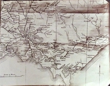 Phillip Island and District Historical Society Inc.
Photograph, Rail Lines of Victoria, Early to mid 20th century
Map showing extensive railway network in Victoria in early C20th.Sepia photo of map of Victoria showing rivers and railway lines and stations.Names of towns, rivers, bays etcsepia photograph, rail transport, victoria, map -
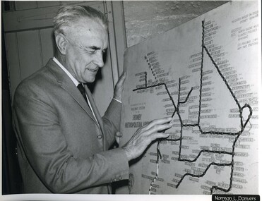 Vision Australia
Photograph - Image, Ron Bruce reading Sydney Train map, 1971?
Ron Bruce reading a Braille map of Sydney's railway network.B/W photograph of man reading braille map1/71016 M&O -historicalroyal blind society of nsw, ron bruce, maps -
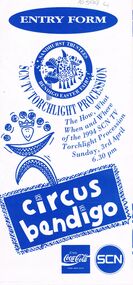 Bendigo Historical Society Inc.
Document - BENDIGO EASTER FAIR COLLECTION: ENTRY FORM TORCHLIGHT PROCESSION 1994, Sunday 3rd April, 1994
Folded entry form, blue print on white, for SCN TV torchlight Procession - the how, what when and where of the 1994 SCN ( Southern Cross Network ) RV torchlight Procession Sunday 3rd April, 6.30 p.m. Circus Bendigobendigo, bendigo easter fair, easter fair society -
Port Melbourne Historical & Preservation Society
Newspaper - Newspaper clipping, The Kitchen Story, History of J Kitchen & Sons, Unichema Australia Pty Ltd, "The Kitchen Story"
"The Kitchen Story". Newspaper clipping about J Kitchen and Sons history, with handwritten date 22/11/1984. Section called "the Company Today" describes Unichema Australia as current name of company which is part of the worldwide Unilever networkindustry - manufacturing, business and traders - soaps/candles, j kitchen & sons pty ltd, unichema australia pty ltd, unilever australia (holdings) ltd -
 Bacchus Marsh & District Historical Society
Map, Bacchus Marsh Tuesday 23rd Oct. 1888, Lodge & Dunn's Paddocks 1888. Business and Mansion Sites
This map was created as a plan for an auction of land close to the Bacchus Marsh Railway Station. The auction took place on 23 October 1888. 102 allotments of land from an area known as Lodge and Dunn's paddocks was offered for sale. The auction was conducted by auctioneers based in Melbourne and was advertised in Melbourne newspapers as well as in the Bacchus Marsh Express newspaper. The auction plan contains a range of details including the selling agents, Munro and Baillieu; W.P. Lockhart; and John Turner, all of Melbourne, deposit terms for purchases, price of railway passes for a return trip from Melbourne to Bacchus Marsh of 1 shilling, and a description of the land as having 'magnificent views and perfect drainage'. A single page paper map showing allotments of land for sale along the Parwan Road in Maddingley. The map is pasted into a bound volume containing 76 maps or plans in total. High resolution digital image stored on BMDHS computer network. At bottom on left side: 'Harston & Co. Lith, Melb.'land sales bacchus marsh, land sales maddingley, bacchus marsh victoria maps, maddingley victoria maps -
 Bacchus Marsh & District Historical Society
Map, Bacchus Marsh Suburban Allotments Parwan Road Lodge & Dunn's Paddocks 1888
This map was created as a plan for an auction of land close to the Bacchus Marsh Railway Station. The auction took place on 23 October 1888. 102 allotments of land from an area known as Lodge and Dunn's paddocks was offered for sale. A single page paper map showing allotments of land for sale along the Parwan Road in Maddingley. The map is pasted into a bound volume containing 76 maps or plans in total. High resolution digital image stored on BMDHS computer network. land sales bacchus marsh, land sales maddingley, bacchus marsh victoria maps, maddingley victoria maps -
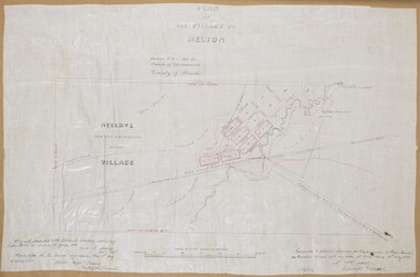 Bacchus Marsh & District Historical Society
Map, Plan of the Village of Melton
A single page paper map showing a plan for the village of Melton, Parish of Djerriwarrh, County of Bourke. The map is pasted into a bound volume containing 76 maps or plans in total. High resolution digital image stored on BMDHS computer network. melton victoria maps -
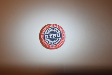 Melbourne Tram Museum
Badge - RTBU Badge, Rail Transport and Bus Union (RTBU), c.2010s
Used for pinning onto clothing or other accessories. Advertisement of the RTBU is printed on one side.A recent item advertising the RTBU.Round metallic badge with the text "WE RUN THE NETWORK" and "RAIL TRAM TRAM & BUS UNION" printed in front in concentric red and white circles. Nestled within are the lines "RTBU" and "THE POWER OF UNION" printed in white, horizontally on a blue background.public transport, rtbu, unions -
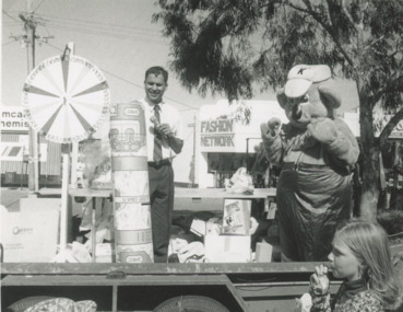 Lakes Entrance Historical Society
Photograph - Market, Lakes Post Newspaper, 1/12/1995 12:00:00 AM
Black and white photograph taken of spinning wheel and Kenny Koala on truck tray set up for Myer Street Traders Twilight Market. In background Fashion Network previously Stewart's Butchers and Galleon Coffee Lounge Lakes Entrance Victoriatrading, business -
 Bacchus Marsh & District Historical Society
Map, Tracing of plan shewing portion through Bacchus Marsh District of proposed new Main Road between Gisborne and Blackwood
Road construction and planning was a primary function of the early local government authorities in rural and regional Victoria. This plan is indicative of the sort of documentation which generated considerable public interest and comment in rural communities. The date of this plan is not clear. Newspaper articles in the Bacchus Marsh Express around 1869 contain numerous references to the proposed new road between Gisborne and Blackwood which suggests this plan may date from the late 1860s or early 1870s.A single page paper map showing the proposed route of a main road to be constructed between Gisborne and Blackwood. The map is pasted into a bound volume containing 76 maps or plans in total. High resolution digital image stored on BMDHS computer network. roads, road plans, bacchus marsh victoria maps, gisborne to blackwood main road -
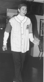 Lakes Entrance Historical Society
Photograph - Fundraising, Lakes Post Newspaper, 1994
fashions from Riviera Sports, Shop 21, Mr Trendi, Fashion NetworkBlack and white photograph Anthony Wolfski modelling young mens fashions, Fashion Show supporting Miss Australia Entrant Colleen Harrington. Lakes Entrance Victoria volunteering, fundraising, fashion -
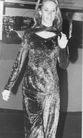 Lakes Entrance Historical Society
Photograph - Fashion Show, Lakes Post Newspaper, 1994
fashions from Riviera Sports, Shop 21, Mr Trendi, Fashion NetworkBlack and white photograph Sam Martin modelling fashions, Fashion Show in support of Miss Australia entrant Colleen Harrington. Lakes Entrance Victoria volunteering, fundraising, fashion -
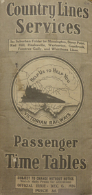 Federation University Historical Collection
Booklet - Timetable, Country Lines Services - Passenger Time Tables (Dec. 6, 1926), 12/1926
The timetable included fare prices.Grey covered slimline 80 page booklet containing the various for timetables of passenger trains on the Victorian regional railway network. Includes indexes of stations and fares, and other information relating to traveling on the train, such as luggage transport. The cover features a picture of a train on the fronttime table, country lines, victoria, railways, train, timetable, transport, railway -
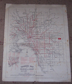 Ballarat Tramway Museum
Map, Melbourne and Metropolitan Tramways Board (MMTB), "Tramway Map of Melbourne and Suburbs", 1930c
Two colour map of Melbourne tramway Network, undated, but post the conversion of Collins St to electric trams (late 1929), c1930. Shows both electric and cable lines, various locations, eg the Motordrome, railway lines and primary streets. Compiled by the MMTB.On rear in pencil over three locations "Young Asst Mgr", "Young" and "L Calder? 6 Inglis? Wahroonga"trams, tramways, mmtb, map, cable trams, conversion