Showing 233 items
matching old post office hill
-
 Ballarat Heritage Services
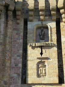
Photograph - Colour, Masons' Marks, Old Sarum, England, English Heritage Site, 01 November 2016
William the Conqueror inherited Old Sarum from the last Saxon king of England. It was an ideal site for a royal castle. It was here in 1070 that William paid off his army after a long and bitter campaign in northern England. It was here in 1086 that he called together all the major landholders in England so they could swear allegiance to him. It was a crucial moment. The Domesday Book was being written, a threatened Viking invasion had only just been averted and William's eldest son was in armed rebellion. Old Sarum was an important place where this Norman king of England held power. In 1794 the Ordnance Survey set out to check the accuracy of the first mapping of Southern England, which had begun ten years earlier. From a point just below Old Sarum Lieutenant William Mudge laid out a base-line 36,574 feet (11,253 metres) long. From each end of the line the positions of distant places were plotted using a huge theodolite made in 1791 by Jesse Ramsden. The accuracy of the process, which was repeated all over England, depended on Jesse Ramsden's craftsmanship and on William Mudge's surveying skill in setting out this first base-line from Old Sarum. The nearer end of Mudge's line is marked by an inscribed stone beside the modern A345 at Old Sarum. ordnance survey, william mudge, jesse ramsden, william the conqueror, old sarum, saxon, 1086, england -
 Ballarat Heritage Services
Photograph - Colour, Masons' Marks, Old Sarum, England, English Heritage Site, 2016, 01 November 2016
William the Conqueror inherited Old Sarum from the last Saxon king of England. It was an ideal site for a royal castle. It was here in 1070 that William paid off his army after a long and bitter campaign in northern England. It was here in 1086 that he called together all the major landholders in England so they could swear allegiance to him. It was a crucial moment. The Domesday Book was being written, a threatened Viking invasion had only just been averted and William's eldest son was in armed rebellion. Old Sarum was an important place where this Norman king of England held power. In 1794 the Ordnance Survey set out to check the accuracy of the first mapping of Southern England, which had begun ten years earlier. From a point just below Old Sarum Lieutenant William Mudge laid out a base-line 36,574 feet (11,253 metres) long. From each end of the line the positions of distant places were plotted using a huge theodolite made in 1791 by Jesse Ramsden. The accuracy of the process, which was repeated all over England, depended on Jesse Ramsden's craftsmanship and on William Mudge's surveying skill in setting out this first base-line from Old Sarum. The nearer end of Mudge's line is marked by an inscribed stone beside the modern A345 at Old Sarum. ordnance survey, william mudge, jesse ramsden, william the conqueror, old sarum, saxon, 1086, england -
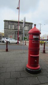 Ballarat Heritage Services
Digital photograph, Lisa Gervasoni, Portland, Victoria, c2015
Colour photorgraph of an old, red pillar box in Portland. portland, heritage, building, bluestone, shops, pillar box, letter box -
 Ballarat Heritage Services
Digital photograph, Lisa Gervasoni, Old Treasury, 2017
... Ballarat Heritage Services PO Box 2209 Bakery Hill Post ...old treasury, heritage, building, renovation, spring street -
 Ballarat Heritage Services
Digital photograph, Lisa Gervasoni, Old Treasury, 2017
... Ballarat Heritage Services PO Box 2209 Bakery Hill Post ...old treasury, heritage, building, renovation, spring street -
 Ballarat Heritage Services
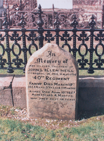
Photograph - Photograph - Colour, Dorothy Wickham, Headstone for the children of John and Ellen Neill, Ballaarat Old Cemetery, 23/09/2004
The 40th regiment fought at the Eureka Stockade.Headstone for Fanny Neill and Agnes Neill in the Ballaarat Old Cemetery, soldiers enclosure. "In memory of John & Ellen Neill corporal in her majesty's 40th Regiment. Fanny died March 19th 1857 aged 3 years & 8 months. Agnes died April 10th 1857 aged 1 year & 4 months. May they rest in peace.john neill, ellen neill, agnes neill, fanny neill, 40th regiment, military, eureka stockade, gravestone, headstone, ballaarat old cemetery, ballarat old cemetery -
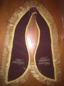 Ballarat Heritage Services
Ceremonial object - Photograph - Colour, Clare Gervasoni, Old Colonists' Association President's Collar, 19/11/2015
... Ballarat Heritage Services PO Box 2209 Bakery Hill Post ...Colour photographs of the Old Colonists' Association Collar, which is worn by the incoming Association President on the installation night. old colonists' association, president's collar, collar, costume, stitchery, embroidery, gold braid, ballarat old colonists' club, ceremonial collar -
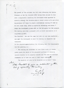 Ballarat Heritage Services
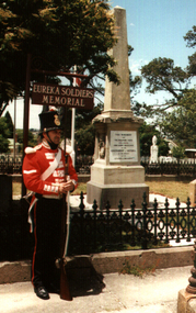
Document - Photocopy, Eureka Soldiers' Graves
The Eureka Stockade was fought on the morning of 03 December 1854. Around 22 soldiers and diggers were killed as the result of the battle. Paper with printed wordsCorrespondence in cemetery files at Community Services Victoria re the disgraceful state of the soldiers' graves in the Ballaarat Old Cemetery. Dated 7.10.91 (1891)eureka graves, ballaarat old cemetery, ballarat old cemetery, miltary, soldier's graves -
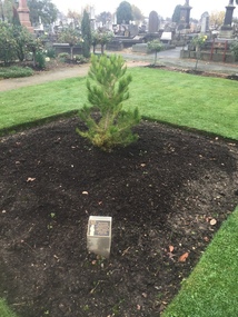 Ballarat Heritage Services
Photograph - Photograph - Colour, Aleppo Pine, Ballarat Old Cemetery, 2016, 05/06/2016
The Lone Pine at Gallipoli was an aleppo pine.Colour photographs of an Aleppo Pine planted in the Ballaalrat Old Cemetery to mark the centenary of the landing at Galipolli.aleppo pine, ballaarat old cemetery, anzac centenary, centenary, anniversary -
 Ballarat Heritage Services
Photograph - Photograph - Colour, Headstone for John Egan, the Drummer Boy at Eureka, 23/09/2004
Historian Dorothy Wickham could not find the death registration for John Egan, and after some research she discovered he did not die on the way to Ballarat, but lived to be Court martialled in New Zealand. It was eventually removed. Photograph of a headstone in the Ballaarat Old Cemetery for John Egan, the Drummer Boy at Eureka. The headstone was erected in the Soldiers Enclosure in the late 1980s. john egan, eureka stockade, military, drummer boy, dorothy wickham, ballarat old cemetery, ballaarat old cemetery -
 Ballarat Heritage Services
Photograph - Colour, Aleppo Pine in the Ballaarat Old Cemetery, 2016, 05 June 1016
A small Aleppo Pine planted in the Ballaarat Old Cemetery on 25 April 2015 to commemorate the centenary of the Gallipoli landing. This tree is genetically related to the Lone Pine at Gallipoli. gallipoli, centenary, ballaarat old cemetery, ballarat old cemetery, aleppo pine, lone pine, anzac centenary -
 Ballarat Heritage Services
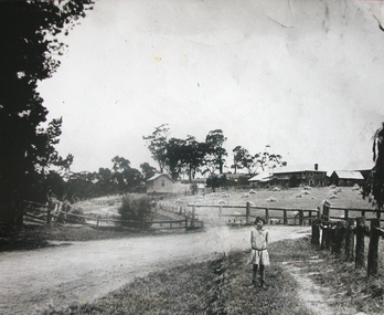
Photograph - Photograph - Black and White, Alice Gervasoni in front of the Old Stone House, Yandoit Creek
The Gervasoni farm at Yandoit Creek was selected in the 1860s by a coopertaive comprising Caro Gervasoni, Luigi Gervasoni, Ambrogio Invernizzi and Battista Nani.Alice Gervasoni stands in front of an old stone house in Yandoit Creek, in a paddock of stooked hay. The house was built by a partnership between Carlo Gervasoni, Luigi Gervasoni, Antonio Invernizzi and Battista Nani.alice gervasoni, luigi gervasoni, carlo gervasoni, battista nani, ambrogio invernizzi, hay, hay stook, stone house, drystone, farm, agriculture -
Ballarat Heritage Services
Database, Ballarat Heritage Services, Ballarat Heritage Services Ballaarat Old Cemetery Database, 2005
... Ballarat Heritage Services PO Box 2209 Bakery Hill Post ...ballaarat old cemetery, ballarat old cemetery -
 Ballarat Heritage Services
Photograph - Colour, Eureka Soldiers Graves at Ballaarat Old Cemetery, c2000
Two colour photographs at the Eureka Soldiers Graves at Ballaarat Old Cemetery.eureka stockade, ballarat old cemetery, ballaarat old cemetery, military, soldiers graves -
 Ballarat Heritage Services
Photograph - Black and White, Old Curiosity Shop, Ballarat
... Ballarat Heritage Services PO Box 2209 Bakery Hill Post ...Back and white photograph of Ballarat's Old Curiosity Shop. old curiosity shop, ballarat, mosaic, architecture -
 Ballarat Heritage Services
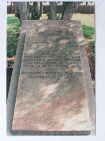
Photograph - Colour, Littlehales Gravestone in Ballaarat Old Cemetery, 23/09/2004
... Ballarat Heritage Services PO Box 2209 Bakery Hill Post ...Colour photograph of a headstone in the Ballaarat Old cemetery, Soldiers' Enclosure.To the memory of Captain C.R. Littlehales 12th Regiment who died February 12th 1855 aged 29 years and 9 months also of Privates William Webb and Felix Boyle who died from the effects of gun shit wounds recived in discharge of duty on the 3rd December 1854 also of Private John Hall who died December 31st 1854. littlehales, ballaarat old cemetery, military, eureka stockade, 12th regiment -
 Ballarat Heritage Services
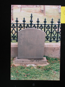
Photograph - Colour, Gravestone of John Neill in the Ballaarat Old Cemetery, 23/09/2004
Colour photograph of a gravestone in the Soldiers enclosure at the Ballaarat Old Cemetery.In memory of the beloved children of John and Ellen Neill Corporal in her majesty's 40th Regiment. Fanny died March 10th 1857 aged 3 years & 8 months. Agnes died April 10th 1857 aged 1 year and 4 months. May they rest in peace.john neill, ballaarat old cemetery, ballarat old cemetery, eureka stockade, headstone -
 Ballarat Heritage Services
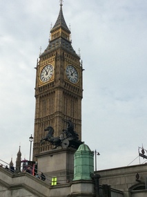
Digital photograph, Dorothy Wickham, Big Ben, London, 2016, 19/09/2016
Colour photograph of an old clock tower in London known as Big Ben.big ben, clock, horology, london, architecture -
 Ballarat Heritage Services
Digital Photograph, Drogheda Museum, Ireland, 2016, 09/2017
The museum houses an extensive collection. It provides educational programmes for schools and other groups. There is a unique collection of 19th century guild banners representing Weavers, the Shoemakers, and the Carpenters. Trade banners also represent the Brick and Stonemasons, Farm Labourers and the Boyne Fishermen. The Old Drogheda Society founded in 1964 by a group of concerned citizens for the preservation of Drogheda's historical monuments and the collection and recording of historical material relating to the town and surrounding area established the award winning museum. The Museum was opened in 1974 and in 2013 achieved full accreditation by the Heritage Council. -
 Ballarat Heritage Services
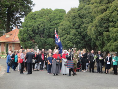
Photograph - Colour, Clare Gervasoni, Unveiling of gravestone for Annie Maynard Smith, World War One Nurse, Ballaarat Old Cemetery, 2016, 27/02/2016
world war one, annie maynard smith, ballaarat old cemetery, nurses, geoff howard, catherine king, garry snowden, trina jones, faye threlfell, world war one centenary, cemetery, gravestone -
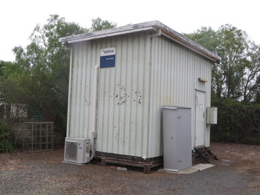 Ballarat Heritage Services
Photograph - Colour, Telepone Exchange at Cressy, Victoria, 2016, 26/01/2016
Colour photographs of old telephone and post office infrastructure at Cressy, Victoria.cressy, telephone exchange, telephone, payphone, church, cressy public hall, post office -
 Ballarat Heritage Services
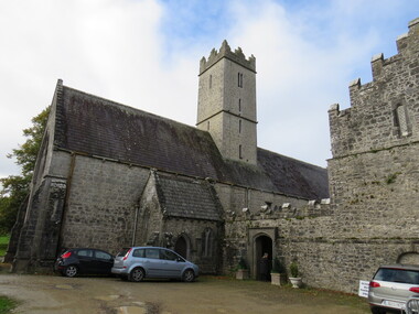
Photograph - Colour, St Nicholas' National School, Adare, Ireland, 2016, 09/2016
St Nichols' National School, Limerick, Ireland, is near the Adare Church, built on the grounds of good land beside a river where three groups of monks made their home during the Middle Ages. The Church was formerly the Black Friar's Abbey. The monastery was founded by John, Earl of Kildare, in 1315. The name of the old parish church was St Niholas where the school derived its name. On 2 June 1808 the local vestry meeting of the Church decided to abandon the old parish church of St Nicholas, the ruins of which are on the Estate, and the old Black Abbey was restores. The remains of the monasteries of all three orders of monks are in relatively good order still (considering their age) and two of them have been restores for worship. The first is the Trinitarian Abbey, otherwise known as the White Abbey, which is in the centre of the village of Adare. This was once the mother-house of a small influential order which had as its main object the ransoming and redeeming of Christian captives from the Moslems. The second is the ruin of the Franciscan Abbey in the demesne, beside the gold course. The third is the Augustinian Priory or the Black Friars' Abbey founded in 1315 by John, Earl of Kildare. Reference: Adare Church by The Right Reverend R. Wyse Jackson LITT.D., LL.D., D.D., Bishop of Limerick 1961-1970.st nicholas' national school, national school, education, schools, adare, ireland -
 Ballarat Heritage Services
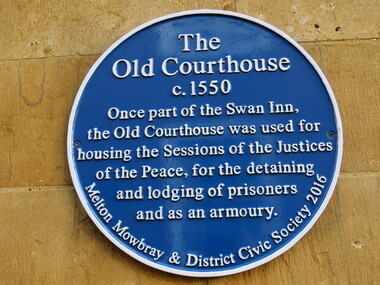
Digital Photograph, Old Courthouse, Melton Mowbray, UK
... Ballarat Heritage Services PO Box 2209 Bakery Hill Post ... -
 Ballarat Heritage Services
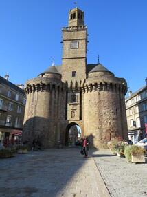
Digital Photograph, Old Gateway, Vire, France, October 2016
... Ballarat Heritage Services PO Box 2209 Bakery Hill Post ...The Old Gateway or the Saint-Sauveur Gateway (13th Century). After the old regime it had, for some time, served as a Town Hall. In august 1944, the US troops, eager to facilitate truck traffic provisioning the frontline, wanted to blow up this tower. It was saved by the energetic intervention of Mayor Andre Halbout. The town plan of 1946 rerouted Chaussee Street, which now passes to the north of the tower. The south tower, its twin, disappeared in 1788.Colour photograph of the Old Gateway, Vire, Franceold gateway, vire, france -
 Ballarat Heritage Services
Digital Photograph, Old Gateway Tower, (detail), Vire, France, 10/2016
Colour photographs of the Old Gateawy Tower, Vire, France -
 Ballarat Heritage Services
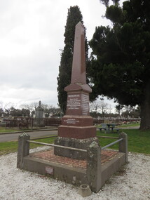
Photograph - Photograph - Colour, Clare Gervasoni, New Australasian Mine Disaster Memorial in Creswick Old Cemetery, 2018, 26/08/2018
The New Australasian Gold Mining Company's No 2 shaft was flooded on 12 December 1882, trapping 27 miners, 22 of whom died despite heroic efforts to save them. A number of photographs of the memorial to those who died in the New Australasian Mine Disaster, including names of those who died.new australasian mine disaster memorial, creswick cemetery, creswick old cemetery -
 Ballarat Heritage Services
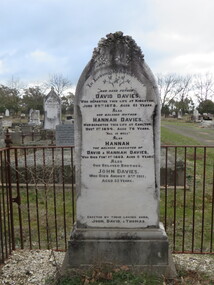
Photograph - Photograph - Colour, Clare Gervasoni, Gravestone for David and Hannah Davies, 2018, 26/08/2018
Gravestone in the Creswick Old Cemetery for David Davies and Hannah Davies.In Loving Remembrance Our dear father who departed this life at Kingston June 29th 1878. Aged 61 years also our beloved mother Hannah Davies who departed this life at Carlton Decr 1st 1894. Aged 76 years "All is well" also Hannah the beloved daughter of David and Hannah Davies, who died Feby 1st 1862. Aged 5 years Also Our beloved brother John Davies, Who died August 8th 1911, Aged 53 years Erected by their loving sons John, David, & Thomascreswick cemetery, creswick old cemetery, david davies, hannah davies, john davies, thomas davies, kingston -
 Ballarat Heritage Services
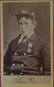
Photograph - Portrait, Thomas Pearce, survivor of the shipwreck Loch Ard, c1887, c1878
Thomas Pearce (1860?-1909) was an apprentice on the English merchant vessel the Loch Ard, which embarked for Victoria in March 1878 carrying 37 crew and 16 passengers, many from the Carmichael family. In stormy weather on 1 June 1878, just days from completing the three-month voyage, the Loch Ard wrecked against Muttonbird Island. Supported by an upturned lifeboat, the teenaged Pearce was washed ashore in a small bay, now known as Loch Ard Gorge; but when he spotted eighteen-year-old Eva Carmichael clinging to wreckage in the ocean, he swam out and struggled back to shore with her. As sole survivors of the wreck, Tom Pearce and Eva Carmichael became celebrities and posed for a number of Melbourne photographers after their recuperation. Pearce was presented with the first gold medal of the Royal Humane Society of Victoria. Popular sentiment was for a permanent union; but Eva returned to Ireland, and Pearce became a ship's captain. This photograph is in an album associated with the Fullerton Family. James Lucas Fullerton was born in Northern Ireland on 02 July 1842, and died on 23 November 1932. HIs wife Mary Carson was born on 30 May 1844 in Northern Ireland, and died on 22 April 1917. They married on 14 October 1869 at Brisbane before moving to Creswick where James Fullerton worked as a grocer. They later moved to Ballarat where they ran a grocery shiop. James and Mary had ten children, and are buried in the Ballaarat Old Cemetery. Photographic portrait of Thomas Pearce wearing the first gold medal of the Royal Humane Society of Victoria.thomas pearce, eva carmichael, loch ard shipwreck, loch ard gorge, royal human society of victoria gold medal