Showing 139 items
matching palm house
-
 City of Kingston
Photograph - Colour, 31 January 1993
Patterson Lakes is a suburb in the City of Kingston that is built one kilometre upstream of the mouth of the Patterson River. The area is bordered by the Patterson River and Eel Race Drain which enters the Kananook Creek. The suburb consists predominantly of newer housing developments and the tidal canal system of the development joins Port Phillip Bay. Patterson Lakes and the Kananook Creek were previously part of the extensive Carrum Carrum Swamp. The area was once a source of fish and eels for the Mayone-Bulluk clan of the Bunurong people. Over time the area was drained and in 1973 investigations commenced into the development of a unique residential area that would be built adjacent to canals and waterways. It was originally proposed to be known as "Gladesville". The development would give the suburb's homeowners access to Port Phillip Bay "from their back door". Circa 1974, the area was rezoned from rural to residential and named Patterson Lakes. Development has been continuous since the 1970s with construction of residential housing, schools, shopping centres, marinas, a hotel and library.Laminated colour aerial photograph of the Carrum and Patterson Lakes region within City of Kingston. This 1993 image includes Patterson River Secondary College, Roy Dore Reserve, Kananook Creek and Nepean Highway. The railway line can be seen as it veers inland from Eel Race Road, Seaford. The section of Ocean Reef Drive and Palm Beach Drive in Patterson Lakes appears to be a recent development with many spare blocks and new houses under construction.Black typed lettering on white adhesive label: 31.1.93 Black typed lettering on white adhesive label: 27E/7140 31/1/93 12.55 pm Black typed lettering on white label: 7140 Yellow round adhesive label located on left sidepatterson lakes, seaford, kananook creek, carrum carrum swamp, canals and waterways -
City of Kingston
Photograph - Colour, c. 1993
Patterson Lakes is a suburb in the City of Kingston that is built one kilometre upstream of the mouth of the Patterson River. The area is bordered by the Patterson River and Eel Race Drain which enters the Kananook Creek. The suburb consists predominantly of newer housing developments and the tidal canal system of the development joins Port Phillip Bay.Patterson Lakes and the Kananook Creek were previously part of the extensive Carrum Carrum Swamp. The area was once a source of fish and eels for the Mayone-Bulluk clan of the Bunurong people. Over time the area was drained and in 1973 investigations commenced into the development of a unique residential area that would be built adjacent to canals and waterways. It was originally proposed to be known as "Gladesville". The development would give the suburb's homeowners access to Port Phillip Bay "from their back door". Circa 1974, the area was rezoned from rural to residential and named Patterson Lakes. Development has been continuous since the 1970s with construction of residential housing, schools, shopping centres, marinas, a hotel and library.Laminated colour aerial photograph of the Carrum and Patterson Lakes region within City of Kingston. This 1993 image includes Patterson River Secondary College, Roy Dore Reserve, Kananook Creek and Nepean Highway. The railway line can be seen as it veers inland from Eel Race Road, Seaford. The section of Palm Beach Drive, Curlew Point Drive, Snapper Point Drive, Clipper Island and Myola Street in Patterson Lakes appears to be a recent development with many spare blocks and new houses under construction.patterson lakes, seaford, kananook creek, carrum carrum swamp, canals and waterways -
 Bendigo Historical Society Inc.
Postcard - BLANCHE SLY POSTCARD COLLECTION, 1900 - 1920
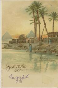
Postcard Album of Blanche Sly. Postcards stored in Folder 81 (49 postcards). 1403.1 - 1403.28 Grey linen look cover with picture of a small sailing boat pasted centre front pf cover. Partly torn sticker on lower LH corner. Blanche Victoria SLY Born: 11 Oct 1890, daughter of William and Hannah Sly Address: 1913; Loddon Vale Address: 1980; 100 Barnard Street Bendigo Died: Bendigo 12 June 1982, buried Bendigo G3 William Sly: Born: 1856 at Smythesdale, Victoria Married in Victoria in 1887; Hannah Theilman Died: Bendigo 1937, buried Bendigo G1 Hannah Sly Nee Theilman Born: 1866 Married in Victoria in 1887; William Sly Died: Bendigo 1948, buried Bendigo G3 See additional Research .Postcard Album of Blanche Sly containing 49 postcards. See 1403 Coloured picture of riverside houses with a well and palm trees. Woman with a jar on her head. The pyramids of Sakkarah in the background. Egypt . Addressee - Mrs. W Sly, Loddon Vale Sender - Pte T Olgaiti Not datedpostcard, collector, blanche sly -
Merbein District Historical Society
Journal - Quarterly, Merbein Historian - Journal MDHS - No 10 (The Newsletter) (2 copies)Dec. 2002, Dec.2002
carrie pollock (guest spkr.), common merbein, malcolm mcfarlane (guest spkr.), betty smith, merbein golf club, william h. bennett, rhoda bennett, harold ball, honor avenue palm trees, homer hollis, martha hollis, houses, trains, police, val allan, bill russell, merbein turf club -
 Bendigo Historical Society Inc.
Photograph - HILDA HILL COLLECTION: BLACK AND WHITE PHOTOS, 1917-1922
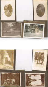
Series of Black & White Photos Total 8 Hill Family & Friends during the final years of World War I and into the touring boom of the 1920s. Lady dressed in all white, with dark coloured scarf over her shoulder, parasol in her right hand, in conversation with The Dean January 28th 1918.Oval photo of young girl dressed in dark skirt and white blouse in bush setting with trees in background, photo not very clear, 'Durvol' Kyneton 1918. Mollie & Babe Railway Reserve Kyneton, girl in light coloured dress reclining on the ground, other girl in kneeling position wears dark skirt and white blouse, palm tree to the left background, further back is paling fence, shrubbery to the right background, 1918. Horse & 4 wheeled Gig, man seated wears a dark suit with white shirt and dark tie, horse appears to be a grey colour, background shows bull nose veranda roof and part of a house gable, tree in framework on nature strip. Nell wearing a dark skirt and white top, right hand touching a shrub, white structure in the background, 'The Ranch' Eppalock November 1918. Botanical Gardens group photo, six young ladies, one wearing a vertical striped dress, three wear dark dresses with white blouses, two wear white blouses and dark skirts, one black hat and three light coloured, light hat in right foreground, January 1919. Jack & Mick in dark suits, white shirts, striped ties, shrubbery in the background, long trousers 'The Ranch' Eppalock January 14th 1917. two young ladies in all white, one holding a hat, young boy in dark clothing white shirt and dark tie, holding long stick, large shrub in the background, 'The Pines' Kyneton January 1919.Hilda Hill Personal Collectionaustralia, history, post war life -
 Bendigo Historical Society Inc.
Photograph - T C WATTS & SON COLLECTION: BENDIGO HOUSE, 1927
Brydon Stewart Melrose (1895-1989) was a dentist. He married Florence Emily Reville in 1921. Their home in Myrtle Street was called Morayfield. In the mid to late 1930's they moved to Boundary Street.Black and white photograph mounted on rectangular grey board. House, weatherboard, cement sheet and timber under eaves. Double door entrance. Rough cast cement verandah with timber posts. Two palms in front. Timber top rail to closely slatted wooden fence, chimney pots visible. On back of photo:" Bryden Melrose, £850, Date stamp 9 December 1927. refer S & U, D.T. Coy first'Frank A. Jeffree Bendigoplace, building, residential, stamped on back in rectangle ''t.c. watts and son/auctioneer/estate agents/253 mitchell street/bendigo'' stamped on back in circle ''royal historical society of victoria, bendigo branch'' -
 Bendigo Historical Society Inc.
Photograph - T C WATTS & SON COLLECTION: HIGH STREET AND MYRTLE STREET CORNER, 1928
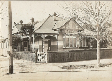
Gordon Frederick HawleyBlack and white photograph mounted on rectangular grey board. House, two tone weatherboard, triple window on front Return verandah . Front and side entrance. Fretwork trim to verandah. Ornate wooden gate. Picket fence with capping, corrugated iron roof with snailback trim. Small palm front garden. Trimmed hedge.On back of photo: ' Gordon Hawley ( crossed out) High and Myrtle St., £1400 sold' Date stamp 25 August 1928.Frank A. Jeffree Photo Bendigo [White Ink]bendigo, business, t c watts and son, s -
 University of Melbourne, Burnley Campus Archives
Photograph - Black and white print, Principal's Residence, 1940's
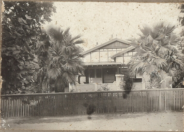
Appears as an illustration in, "Green Grows Our Garden," A.P. Winzenried p 109.Black and white photograph. Principal's Residence, Taken to effectively show the trees and garden beds around the house. In a central position is a fine specimen of a palm. Tall cypresses to the left of the house.On reverse, "1940's."principal's residence, green grows our garden, a.p. winzenried, palm, cypress -
 Whitehorse Historical Society Inc.
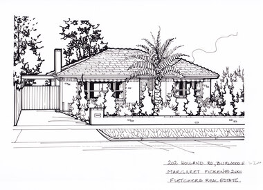
Artwork, other - Ink Line Drawing, 202 Holland Rd., Burwood E, 1994
... Cottage Housing Architecture Margaret Picken Burwood House Garden ...A property illustration by Margaret Picken Commissioned by the real estate agency Fletchers Real Estate for the purpose of advertising 202 Holland Rd, Burwood East in 2001 Made by using Rotring ‘Rapidigraph’ drafting pens with Rotring ink on Rapidigraph polyester drafting film, double matte. Trained as a cartographic draftsman within the mining industry, Margaret Picken is an artist who worked producing property illustrations for real estate agencies in eastern suburbs of Victoria from 1983-2005. Retiring from the industry as technological changes favored coloured photography over illustrations, and commissioning companies over sole contractors.This artwork is of Historical Significance as a record of local domestic architecture.A black ink line drawing on drafters film by Margaret Picken, of 202 Holland Rd., Burwood East. A one story brick house, with a driveway leading to gated carport on the left. In the foreground is a low brick fence, and front lawn filled with hedges, and a large palm tree.202 Holland Rd., Burwood E. Margaret Picken © 2001 Fletchers Real Estatewhitehorse historical society, schwerkolt cottage, housing, architecture, margaret picken, burwood, house, garden, burwood east, palm tree -
 Bendigo Historical Society Inc.
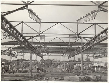
Photograph - BENDIGO: B.L.B. FACTORY, BREEN STREET, 1950's - 60's ?
... . Houses in background, palm trees in some gardens.,... under construction. Workmen on site. Reinforcing mesh . Houses ...black and white photo: construction girders, building under construction. Workmen on site. Reinforcing mesh . Houses in background, palm trees in some gardens.,Reg. V. Brock, Bendigo written on back green and white adhesive label on back B 1098 ( add copies mayu be obtained by quoting this number. RHSV stamped on back, Bendigo Branch.buildings -
 Bendigo Historical Society Inc.
Photograph - T C WATTS & SON, 1927
BHS CollectionBlack and white photograph mounted on rectangular grey board. House, large elevated w/board with tiled roof. Ventilated eaves and rough cast insert to front gable. Steps to side verandah with balustrade. Casement windows to front and side bay window double wooden verandah posts, palms, fruit trees and ground cover creepers in garden.Not legibleplace, building, residential, stamped on back in rectangle ''t.c. watts and son/auctioneer/estate agents/253 mitchell street/bendigo'' stamped on back in circle ''royal historical society of victoria, bendigo branch'' -
 Bendigo Historical Society Inc.
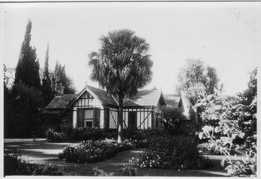
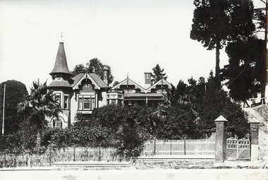
Photograph - THE EYRIE: QUARRY HILL, pre 1932
Black and white photo, 'The Eyrie' turretted and gabled roof line. Picket fence, brick pillars on gatewah with gravel path up on right to pine trees. Overgrown garden, with palm trees. On stick on label ' date unknown pre 1922 when steps were put in palms now well grown. Verandah canopy no longer striped wooden gates gone. House restored in 1998. To original colour scheme and verandahs now striped.buildings, residential, the eyrie -
 Bendigo Historical Society Inc.
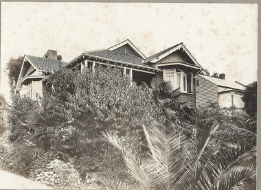
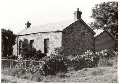
Photograph - STONE HOUSE, Late 1960s
House, Stone, weatherboard addition at back, corrugated iron roof, cyclone wire fence, 2 brick chimneys with terracotta pots, palm tree at left, creeper growing on fence. Central door, 1 window each side of doorAlan Doneybuilding, residential -
 Melbourne Tram Museum
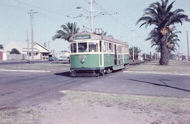
Slide, Keith Caldwell, 12/03/1960 12:00:00 AM
Agfa Colour slide, cardboard mount, by Keith Caldwell dated 12 March 1960, of W5 818 running in Mount Alexander Road, North Essendon, crossing the street access for Marco Polo Street. The tram showing route 59, Essendon Aerodrome, has trolley wheels and has a second person in the cab, possibly a trainer. Unusually the tram number is placed above the headlight, In the background are the palm trees in the centre median plantation. The house with the red guttering is one that dates back to the gold mining era. See http://www.esshissoc.org.au/1070%20Mount%20Alexander%20Road.pdf It was relocated to Woodland Park during 2017? Note the Centre poles, overhead construction and street light. Also in the background is a Mobil Service station that later became a garden centre. Now a block of apartments.hand stamped "12 Mar '60"trams, tramways, mount alexander rd, north essendon, essendon airport, essendon aerodrome, route 59, w5 class, tram 818 -
 Port Melbourne Historical & Preservation Society
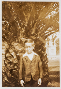
Photograph - Robert Cornelius Watters in front of palm tree c 1928
The Watters family moved from Albert Park to Garden City Port Melbourne circa 1934 buying a Bank House at 128 Williamstown Road (later renumbered to 400). The family consisted of Bob Watters senior and his wife Ellen (nee Oakley), children Patsy (b 1920), Bob Junior (b 1922) and Norma (b1924). The children attended Albert Park Primary, Middle Park Central School and then MacRobertson Girls High School and Melbourne Boys High School.Robert (Bob) Cornelius Watters in front of palm tree c 1928 bob watters junior, robert cornelius watters -
 Glen Eira Historical Society
Photograph, Beauville Avenue, 6, Murrumbeena, 2001
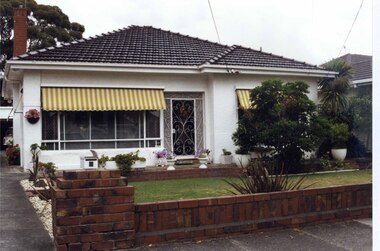
Originally labelled "Beauville Estate, Established 1936, Still Thriving 65 years on, 10th March 2001", the Beauville Estate Album contains colour photographs of houses in the Estate. They were taken around the time of the Beauville Estate’s 65th Heritage Celebration held on 10/03/2001 and donated to the Caulfield Historical Society shortly afterwards. Photographer Bev Baxter. City of Glen Eira’s Heritage Management Plan Vol 2 p79 (this is p84 of the pdf version) – HO12 Beauville Estate and environs, Murrumbeena: The Beauville Historic Area is important at the State level as the first large housing estate undertaken by the AV Jennings Construction Co, later Jennings Group Limited, Victoria’s largest home builder. It is important also as a very early estate development incorporating a range of features other than houses and including made roads, shops and recreation facilities. In this respect it was the forerunner of the comprehensively planned housing estate of the post war era. The estate is distinguished by its aesthetic values, as is the earlier and comparable Hillcrest Estate, which are formed by a combination of restrained diversity in house styles, with the exception of no. 30 in the emerging International style, and by a landscaped garden environment. Colour photograph of a white rendered house with striped yellow and white window awnings. Other features include a tiled roof, a cast iron work front porch door, garden urns in front of the house and a low unpainted brick fence in the foreground with a car in its garage down the drive to the left. The garden beds are also supported by walls of the same unpainted bricks with plants including a palm and succulents.murrumbeena, houses, beauville avenue, architectural styles, 1930's, inter war style, a.v. jennings, av jennings, jennings, brick houses, beauville estate, porches, sir albert victor jennings, a v jennings construction co, beauville estate heritage area, glen eira city council, architectural features, jennings group limited, land subdivision, gardens, beauville historic area, cast iron work gates, striped awnings, outdoor ornaments, brick fences, drives, cars, garages (private), palm trees, brick chimneys -
 Stawell Historical Society Inc
Photograph - Oban Stawell RSL, Stawell RSL with Palm Tree
Stawell R.S.L. Formerly "Oban" Private residence of a Mine Owner.Former mine owners residenceB/W photo Stawell R.S.L. after balconies removed taken from Scallon St. Sows front door and steps. Lattice fence to back yard. removed white with black lettersstawell houses -
 Bendigo Historical Society Inc.
Photograph - FORTUNA COLLECTION: FORTUNA GARDENS
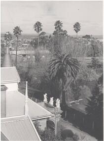
Black and white photoghraph taken from top of Fortuna Villa, looking down on garden with Bendigo city in background. Large palms in garden. Three sculptures over entry to Villa.bendigo, house, fortuna villa -
 Lakes Entrance Historical Society
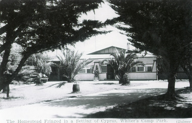
Photograph - Whiters Camp Park, Bulmer H D, 1940c
Black and white photograph showing the Homestead at Whiters Camp Park. Foreground has large cypress trees, lawn and date palms. Lakes Entrance VictoriaEntertainment and Community Rotunda, Whiters Parkresort, houses, vegetation