Showing 836 items
matching parish map
-
 Bendigo Historical Society Inc.
Map - JACK FLYNN COLLECTION: BONN, 16/07/1919
... Map: Parish of Bonn, County of Rodney. Parish plan.... of Lands and Survey. Melbourne by W. J. Butson. Map: Parish of Bonn ...Map: Parish of Bonn, County of Rodney. Parish plan.By Authority A. J. Mullett. Government Printer, Melbourne. Photo Lithographed at the Department of Lands and Survey. Melbourne by W. J. Butson.map, rodney, parish plan, bonn, rodney -
 Bendigo Historical Society Inc.
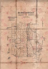
Map - JACK FLYNN COLLECTION: BURRUMBOOT, August 1951
... Map: Parish of Burrumboot, County of Rodney. Parish plan.... of Lands and Survey, Melbourne, Victoria. August 1951 Map: Parish ...Map: Parish of Burrumboot, County of Rodney. Parish plan.By Authority J.J. Gourley, Government Printer Melbourne. Drawn and Reproduced at the Dept of Lands and Survey, Melbourne, Victoria. August 1951map, rodney, parish plan, burrumboot, rodney -
 Bendigo Historical Society Inc.
Map - JACK FLYNN COLLECTION: BEALIBA, 15/09/1931
... Map: Parish of Bealiba, County of Gladstone. Parish plan.... and Survey Melbourne. 15.9.31 Map: Parish of Bealiba, County ...Map: Parish of Bealiba, County of Gladstone. Parish plan.By Authority H.J. Green, Government Printer. Photo Lithographed at the Government of Lands and Survey Melbourne. 15.9.31map, gladstone, parish plan, bealiba, gladstone -
 Bendigo Historical Society Inc.
Map - JACK FLYNN COLLECTION: BAMAWM, 19/08/1924
... Map: Parish of Bamawm, County of Bendigo. Parish plan.... of Lands and Survey, Melbourne by W.J. Butson. 19.8.24 Map: Parish ...Map: Parish of Bamawm, County of Bendigo. Parish plan.Photo Lithographed at the Department of Lands and Survey, Melbourne by W.J. Butson. 19.8.24map, bendigo, parish plan, bamawm -
 Bendigo Historical Society Inc.
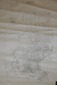
Map - JACK FLYNN COLLECTION: HUNTLY, August 1954
... Map: Parish of Huntly, County of Bendigo. Parish plan...., Melbourne, Victoria. August 1954. Map: Parish of Huntly, County ...Map: Parish of Huntly, County of Bendigo. Parish plan.By Authority W.M. Houston, Government Printer. Drawn and Reproduced at the Dept, of Lands and Survey, Melbourne, Victoria. August 1954.map, bendigo, parish plan, huntly -
 Bendigo Historical Society Inc.
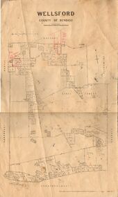
Map - JACK FLYNN COLLECTION: WELLSFORD, 2/11/1914
... Map: Parish of Wellsford, County of Bendigo. Parish plan.... of Lands and Survey Melbourne By H.J. Butson. 2-.11.14 Map: Parish ...Map: Parish of Wellsford, County of Bendigo. Parish plan.Photo-Lithographed at the Department of Lands and Survey Melbourne By H.J. Butson. 2-.11.14map, bendigo, parish plan, wellsford -
 Bendigo Historical Society Inc.
Map - JACK FLYNN COLLECTION: YARRAYNE, 6/01/1932
... Map: Parish of Yarrayne, County of Bendigo. Parish plan...., Melbourne. 5.1.32. Map: Parish of Yarrayne, County of Bendigo ...Map: Parish of Yarrayne, County of Bendigo. Parish plan.By Authority, H.J. Green, Govt., Printer. Photo-Lithographed at the Department of Lands and Survey, Melbourne. 5.1.32.map, bendigo, parish plan, yarrayne -
 Bendigo Historical Society Inc.
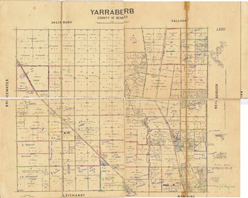
Map - JACK FLYNN COLLECTION: YARRABERB, NO date visible
... Map: Parish of Yarraberb, County of Bendigo. Parish plan....., Printer. Map: Parish of Yarraberb, County of Bendigo. Parish plan ...Map: Parish of Yarraberb, County of Bendigo. Parish plan.By Authority H.J. Green. Govt., Printer.map, bendigo, parish plan, yarraberb -
 Bendigo Historical Society Inc.
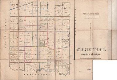
Map - JACK FLYNN COLLECTION: WOODSTOCK, 27/03/75
... Map: Parish of Woodstock , County of Bendigo. Parish plan.... of Lands and Survey Melbourne by J. Noone. 27.3.79 Map: Parish ...Map: Parish of Woodstock , County of Bendigo. Parish plan.Photo-Lithographed at the Department of Lands and Survey Melbourne by J. Noone. 27.3.79map, bendigo, parish plan, woodstock -
 Bendigo Historical Society Inc.
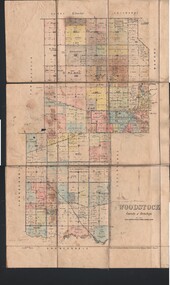
Map - JACK FLYNN COLLECTION: WOODSTOCK, 4/07/1935
... Map: Parish of Woodstock, County of Bendigo. Parish plan...., Melbourne Victoria. 4.7.35 Map: Parish of Woodstock, County ...Map: Parish of Woodstock, County of Bendigo. Parish plan.By Authority H.J. Green. Govt Printer. Drawn and Reproduced at the Dept of Lands and Survey, Melbourne Victoria. 4.7.35map, bendigo, parish plan, woodstock -
 Bendigo Historical Society Inc.
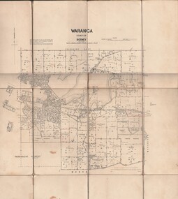
Map - JACK FLYNN COLLECTION: WARANGA, 1959
... Map: Parish of Waranga, County of Rodney. Parish plan.... and survey. Melbourne 1959. Map: Parish of Waranga, County of Rodney ...Map: Parish of Waranga, County of Rodney. Parish plan.By Authority. A.C. Brooks. Government Printer Melbourne. Drawn and Reproduced at the Department of lands and survey. Melbourne 1959.map, rodney, parish plan, waranga -
 Bendigo Historical Society Inc.
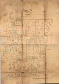
Map - JACK FLYNN COLLECTION: TOOLLEEN, 25/05.1926
... Map: Parish of Toolleen, County of Rodney. Parish plan.... Melbourne. W. J. Butson 25.5.26. Map: Parish of Toolleen, County ...Map: Parish of Toolleen, County of Rodney. Parish plan.By Authority, H.J. Green. Govt., Printer. Photo-Lithographed at the Department of Lands and Survey Melbourne. W. J. Butson 25.5.26.map, rodney, parish plan, toolleen -
 Bendigo Historical Society Inc.
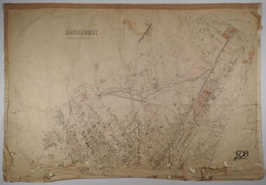
Map - SANDHURST, Circa 1906
... Map: Parish of Sandhurst, County of Bendigo. Parish plan... Bendigo parish plan Sandhurst Map: Parish of Sandhurst, County ...Map: Parish of Sandhurst, County of Bendigo. Parish planmap, bendigo, parish plan, sandhurst -
 Bendigo Historical Society Inc.
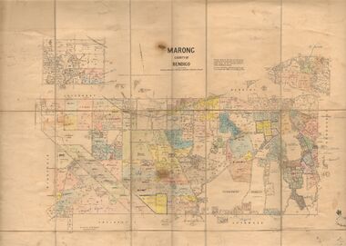
Map - JACK FLYNN COLLECTION: MARONG, June 1933
... Map: Parish of Marong, County of Bendigo. Parish plan....MAP Bendigo parish plan marong By Authority W.M. Houston ...Map: Parish of Marong, County of Bendigo. Parish plan.By Authority W.M. Houston, Government Printer. Drawn and reporduced at the Dept., of Lands and Survey, Melbourne, Victoria.map, bendigo, parish plan, marong -
 Bendigo Historical Society Inc.
Map - SANDHURST, No date Visible
... Map: Parish plan showing the Northern section...MAP Bendigo parish plan Sandhurst Map: Parish plan showing ...Map: Parish plan showing the Northern section of the Municipalitymap, bendigo, parish plan, sandhurst -
 Bendigo Historical Society Inc.
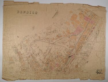
Map - BENDIGO, No date visible
... Map: Parish plan showing the Northern section...MAP Bendigo parish plan Bendigo Map: Parish plan showing ...Map: Parish plan showing the Northern section of the Municipalitymap, bendigo, parish plan, bendigo -
 Bendigo Historical Society Inc.
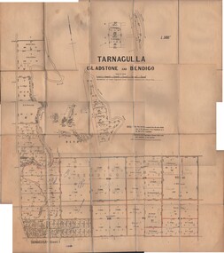
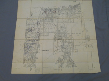
Map - JACK FLYNN COLLECTION: TARNAGULLA SHEET 1, No date visible
... Map: Parish of Tarnagulla Sheet 1, Counties of Gladstone... Gladstone parish plan Tarnagulla Sheet 1 Map: Parish of Tarnagulla ...Map: Parish of Tarnagulla Sheet 1, Counties of Gladstone and Bendigo.map, gladstone, parish plan, tarnagulla sheet 1 -
 Bendigo Historical Society Inc.
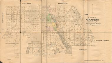
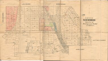
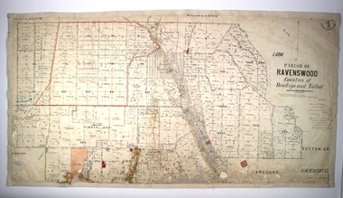
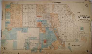
Map - JACK FLYNN COLLECTION: RAVENSWOOD, 12/12/1922
... Map: Parish of Ravenswood, Counties of Bendigo and Talbot... Bendigo parish plan Ravenswood Map: Parish of Ravenswood, Counties ...Map: Parish of Ravenswood, Counties of Bendigo and Talbot. Parish plan.map, bendigo, parish plan, ravenswood -
 Bendigo Historical Society Inc.
Map - JACK FLYNN COLLECTION: RAVENSWOOD, 12/12/1922
... Map: Parish of Ravenswood, Counties of Bendigo and Talbot... and Survey, Melbourne by W.J. Butson Map: Parish of Ravenswood ...Map: Parish of Ravenswood, Counties of Bendigo and Talbot. Parish plan.By Authority A.J. Mullet Government Printer Melbourne. Photo Lithographed at the Department of lands and Survey, Melbourne by W.J. Butsonmap, bendigo, parish plan, ravenswood -
 Bendigo Historical Society Inc.
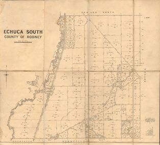
Map - JACK FLYNN COLLECTION: ECHUCA SOUTH, 13/08/1931
... Map: Parish of Echuca South, County of Rodney. Parish plan...., Melbourne. 13.8.31 Map: Parish of Echuca South, County of Rodney ...Map: Parish of Echuca South, County of Rodney. Parish plan.By Authority H. J. Green, Govt. Printer. Department of Lands and Survey, Melbourne. 13.8.31map, rodney, parish plan, echuca south , county of rodney -
 Bendigo Historical Society Inc.
Map - JACK FLYNN COLLECTION: EDDINGTON, 1.12.1925
... Map: Parish of Eddington, Counties of Gladstone and Talbot... of Lands and Survey Melbourne by W.J. Butson 1.12.25 Map: Parish ...Map: Parish of Eddington, Counties of Gladstone and Talbot. Parish plan.Dept of Lands and Survey Melbourne by W.J. Butson 1.12.25map, talbot, parish plan, eddington, counties of talbot, gladstone -
 Bendigo Historical Society Inc.
Map - JACK FLYNN COLLECTION: BET BET SHEET 2, 17/09/1931
... Map: Parish of Bet Bet Sheet 2. Parish plan.... and Survey Melbourne. 17.9.31 Map: Parish of Bet Bet Sheet 2. Parish ...Map: Parish of Bet Bet Sheet 2. Parish plan.Photo Lithographed at the Lands and Survey Melbourne. 17.9.31map, gladstone, parish plan, bet bet -
 Bendigo Historical Society Inc.
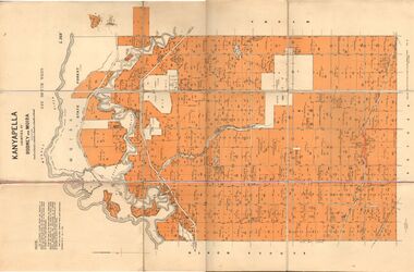
Map - JACK FLYNN COLLECTION: KANYAPELLA, 22/05/1939
... Map: Parish of Kanyapella, Counties of Rodney and Moira...MAP Moira parish plan Kanyapella Counties of Rodney ...Map: Parish of Kanyapella, Counties of Rodney and Moira. Parish plan.By Authority, T. Rider Acting Govt, Printer Melbourne. Drawn and Reproduced at the Dept. of Lands and Survey, Melbourne, Victoria.map, moira, parish plan, kanyapella, counties of rodney and moira -
 Bendigo Historical Society Inc.
Map - PARISH OF RAVENSWOOD, Circa 1908
... Map: Parish of Ravenswood, Counties of Bendigo and Talbot...MAP Bendigo parish plan Ravenswood County of Talbot Map ...Map: Parish of Ravenswood, Counties of Bendigo and Talbot. Parish planmap, bendigo, parish plan, ravenswood, county of talbot -
 Bendigo Historical Society Inc.
Map - PARISH OF RAVENSWOOD, 3/04/1875
... Map: Parish of Ravenswood, Counties of Bendigo and Talbot...MAP Bendigo parish plan Ravenswood County of Talbot County ...Map: Parish of Ravenswood, Counties of Bendigo and Talbot. Parish planmap, bendigo, parish plan, ravenswood, county of talbot, county of bendigo -
 Bendigo Historical Society Inc.
Map - CAMPBELL COLLECTION: BENDIGO AND DISTRICT MAPS
... Map. Parish of Sandhurst, Shire of Strathfieldsaye...MAP Bendigo city streets Map. Parish of Sandhurst, Shire ...Map. Parish of Sandhurst, Shire of Strathfieldsaye, Mandurang Parish, Junortoun.map, bendigo, city streets -
Bendigo Historical Society Inc.
Map - CAMPBELL COLLECTION: PARISH MAPS
... Nineteen Parish maps of Bendigo area in a plastic bag...BHS Collection Nineteen Parish maps of Bendigo area ...BHS CollectionNineteen Parish maps of Bendigo area in a plastic bag. Mostly original maps. Copies or originals of all maps are available to access in the Map Cupboard. Not catalogued separately. Maps come from Don Stewart, 10 Avery's Rd. Eaglehawk. Don now deceased. He worked in a Government job in bendigo. -
 Bendigo Historical Society Inc.
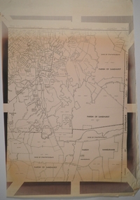
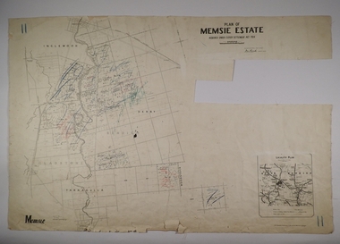
Map - MEMSIE ESTATE, 26/08/1905
... Act 1904. Parish plan. Map dated 26/08/1905..... Parish plan. Map dated 26/08/1905. Map MEMSIE ESTATE ...Map:Plan of Memsie estate, aquired under Closer Settlement Act 1904. Parish plan. Map dated 26/08/1905.map, estate, memsie estate, closer settlement act 1904. -
 Ringwood and District Historical Society
Map, Plan of Country Lands in the Parishes of Nunawading Ringwood and Scoresby - circa 1855
... ' names and property locations. List of Parish map references... Selectors' names and property locations. List of Parish map ...Blueprint copy of Survey Map detailing original Selectors' names and property locations. List of Parish map references including property bearings, distances in Links, and markings on trees. Descriptive remarks include areas marked "Farmer's Common", "Poor soil thickly/moderately timbered with stringy bark", and location of water and firewood reserves."Surveyed and plotted by N.M. Bickford, Superintendant of Mr. Hodgkinson's Field Party". "The land comprised in this survey is of inferior quality, moderately undulating, and thickly wooded. It is watered by Dandenong Creek and Deep Creek." Inset map showing location of (*proposed) cemetery on southern corner of Lillydale Road from Melbourne and Sawmill Road, later Mount Dandenong Road. (*Cemetery did not eventuate.) -
 Bendigo Historical Society Inc.
Map - JACK FLYNN COLLECTION: TARNAGULLA SHEET 3, No date visible
... Map: Parish of Tarnagulla Sheet 3, County of Gladstone... Gladstone parish plan Tarnagulla Sheet 3 Map: Parish of Tarnagulla ...Map: Parish of Tarnagulla Sheet 3, County of Gladstone. Parish plan.map, gladstone, parish plan, tarnagulla sheet 3