Showing 840 items
matching plan of subdivision
-
 Ringwood and District Historical Society
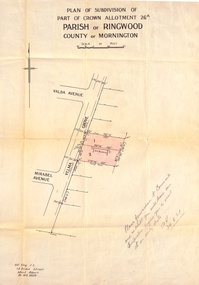
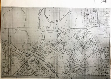
Document, Plan of Subdivision - Part of Crown Allotment 26A, Parish of Ringwood, County of Mornington - Circa 1961
... Plan of Subdivision - Part of Crown Allotment 26A, Parish.... Plan of Subdivision - Part of Crown Allotment 26A, Parish ...Map showing layout of 2 allotments coloured red in Velma Grove, adjacent to Valda Avenue and Mirabel Avenue, Ringwood East, Vic.Handwritten notation dated 29/8/1961 by Alf King, Licensed Surveyor, 14 Grace Street, Mont Albert (Phone) WX2020 regarding plans being forwarded to Council for inspection visit. -
 Ringwood and District Historical Society
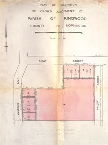
Document, Plan of Subdivision - Part of Crown Allotment 10A, Parish of Ringwood, County of Mornington - 1957
... Plan of Subdivision - Part of Crown Allotment 10A, Parish... inclusive are not included in this plan. Signature of Consulting ...Map of residential allotments in Wantirna Road and Reilly Street, Ringwood, and Philip Street, Heathmont, Vic.Footnote includes "Lots numbered 5 to 11 and 16 to 23 both inclusive are not included in this plan. Signature of Consulting Engineer - Alan J. Brown BCE, LS, MVIS, Licensed Surveyor, Dillons Buildings, 1 Riversdale Road, Camberwell (Phone) WF3528 dated 1-4-1957. -
 Ringwood and District Historical Society
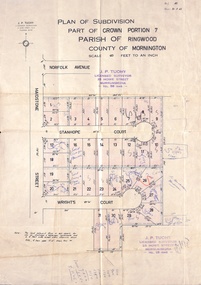
Document, Plan of Subdivision - Part of Crown Portion 7, Parish of Ringwood, County of Mornington - 1962
... Plan of Subdivision - Part of Crown Portion 7, Parish of.... Plan of Subdivision - Part of Crown Portion 7, Parish ...Map of residential allotments coloured red, with land coloured blue set apart for drainage & sewerage easements. Rubber stamped J.P. Tuohy, Licensed Surveyor, 25 Howe Street Murrumbeena, Tel. 561945, dated 38.8.1962.Map includes Maidstone Street, Norfolk Avenue, Stanhope Court and Wrights Court, Ringwood, Vic. Also includes handwritten Estate Agent sales notations. -
 Ringwood and District Historical Society
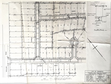
Document, Plan of Subdivision - Golden Wood Estate, Ringwood, Victoria - 1964
... Plan of Subdivision - Golden Wood Estate, Ringwood... and Jennifer Court, off Mullum Mullum Road, Ringwood. Plan ...City of Ringwood drawing No.520 dated October 1964, for construction of Jeffrey Drive, Ronald Street, Golden Grove, Gilda Court and Jennifer Court, off Mullum Mullum Road, Ringwood.Consulting Engineers: Geoffrey C. Bird, 483 Collins Street, Melbourne (Tel) 62 1517. Principal: Commerce and Commission Victoria P/L. -
 Ringwood and District Historical Society
Map, Plan of Subdivision - State School Estate, Ringwood East, Victoria - (Undated, circa 1920s)
... Plan of Subdivision - State School Estate, Ringwood East...Locality plan includes reference to proposed Ringwood East ...Map of land for sale attached to green cardboard backing with handwritten notations showing numbered allotments on Dublin Road, Holland Road, King Street, Charles Street and Purser Avenue, Ringwood East.Locality plan includes reference to proposed Ringwood East railway station which opened in 1925. -
![Planning Document, Plan of proposed subdivision of land in Greensborough [Map shows Scotland house], 01/04/1971](/media/collectors/4f729f5697f83e03086015b8/items/5982a68921ea6b1420e4e560/item-media/59916fb521ea681094908d7a/item-fit-380x285.jpg) Greensborough Historical Society
Greensborough Historical SocietyPlanning Document, Plan of proposed subdivision of land in Greensborough [Map shows Scotland house], 01/04/1971
... Plan of proposed subdivision of land in Greensborough [Map...Part of plan (68G) of proposed subdivision of Greensborough... of plan (68G) of proposed subdivision of Greensborough, part ...This subdivision of Greensborough shows the home of John Scotland (died 1888) and surrounding area bounded by Hailes, William, Lorimer, and Jessop Streets.Photocopy of plan, 2 pages.Part of plan (68G) of proposed subdivision of Greensborough, part of Crown Portion 18, Parish pf Keelbundora. Scale: 132 ft. to an inchjohn scotland, hailes street greensborough, william street greensborough, lorimer street greensborough, jessop street greensborough -
 Greensborough Historical Society
Map, City of Heidelberg, Subdivision plan of Greensborough, 1965c
... Subdivision plan of Greensborough...Subdivision plan of Greensborough including Briar Hill...Copies of subdivision plan for Greensborough... Plenty Lower Plenty melbourne Subdivision plan of Greensborough ...Subdivision plan of Greensborough including Briar Hill and Greenhills. Supplied by Bill Cecil whose parents owned the Greensborough Post Office and it is assumed that these maps were used by Bill (who delivered the post on horseback) to keep up to date with the growing number of new streets and housing in Greensborough.Copies of subdivision plan for Greensboroughgreensborough, briar hill, greenhills -
 Whitehorse Historical Society Inc.
Map, Gill's Springfield Road Estate, 1950?
... by agent from lodged plan of subdivision...Plan of subdivision for Gill's Springfield Road Estate.... Copied by agent from lodged plan of subdivision Land Subdivision ...Plan of subdivision for Gill's Springfield Road Estate, former orchard, 16 lots.Plan of subdivision for Gill's Springfield Road Estate, former orchard, 16 lots. Reprinted by Real Estate Agent, Spencer Jackson.Plan of subdivision for Gill's Springfield Road Estate, former orchard, 16 lots. land subdivision, norway avenue, blackburn, springfield road, blackburn, beverley crescent, blackburn, kevin avenue, blackburn, kerr street, blackburn, bordeaux avenue, blackburn, gill's estate, orchards, spencer jackson -
 City of Moorabbin Historical Society (Operating the Box Cottage Museum)
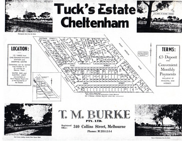
Flyer - Tuck's Estate, Cheltenham, 1940
... Tuck's Estate Cheltenham - plan of subdivision... Cheltenham - plan of subdivision Photocopy of advertising flyer ...After WWII there was a decline in the market gardens in the City of Moorabbin, as the value of the land was more profitable than the crops.Example of the progress of the Municipality of MoorabbinPhotocopy of advertising flyer for sale of real estate sales - plan of building blocks for saleTuck's Estate Cheltenham - plan of subdivisionedward street, point nepean road, eden street, tuck street, hoffman street, elman road, page street, cheltenham, real estates, auction, tuck -
 City of Moorabbin Historical Society (Operating the Box Cottage Museum)
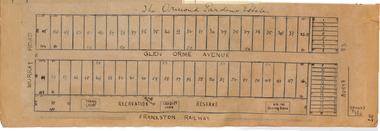
Plan - Ormond Garden Estate, Ormond, 1920
... Hand drawn plan of subdivision... Ormond Garden Estate Hand drawn plan of subdivision Plan Ormond ...At the end of World War One, there was a renewed interest in residential land and a number of estates opened up in the Municipality of Moorabbin. Ormond Garden Estate was auctioned on Saturday 10 April, 1920.Example of the progress of the Municipality of MoorabbinHand drawn plan of subdivisionOrmond Garden Estatenorth road, glen orme avenue, murray road, ormond, auction, real estate -
 City of Moorabbin Historical Society (Operating the Box Cottage Museum)
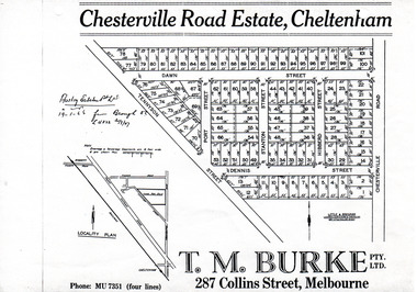
Flyer - Chesterville Road Estate, Cheltenham, 1947
... Chesterville Road Estate, Cheltenham - plan of subdivision... - plan of subdivision Photocopy of advertising flyer for sale ...Chesterville Road Estate, consisting of 101 building lots, was sold by private sale in late 1947.Example of the progress of the Municipality of MoorabbinPhotocopy of advertising flyer for sale of real estate sales - plan of building blocks for saleChesterville Road Estate, Cheltenham - plan of subdivisiontennyson street, port street, dennis street, station street, dawn street, hubbard street, chesterville road, cheltenham, real estate, auction -
 City of Moorabbin Historical Society (Operating the Box Cottage Museum)
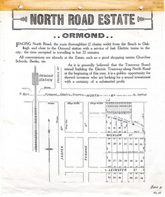
Flyer - North Road Estate, Ormond
... North Road Estate, Ormond - plan of subdivision.36... Estate, Ormond - plan of subdivision.36 Advertising flyer ...At the end of World War One, there was a renewed interest in residential land and a number of estates opened up in the Municipality of Moorabbin.Example of the progress of the Municipality of MoorabbinAdvertising flyer for auction of real estate sales - plan of building blocks for saleNorth Road Estate, Ormond - plan of subdivision.36north road, wicklow st, leinster st, ormond, real estate -
Ringwood and District Historical Society
Envelope, Estate Agents - various plans and notes of Ringwood Subdivision
... Estate Agents - various plans of Subdivision; Notes... of Subdivision; Notes on Subdivisions Estate Agents - various plans ...Estate Agents - various plans of Subdivision; Notes on Subdivisions -
 Ringwood and District Historical Society
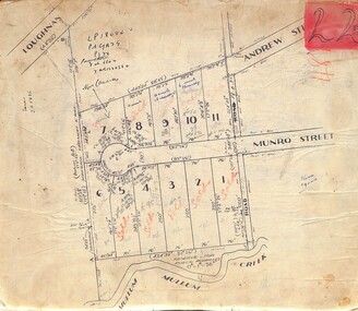
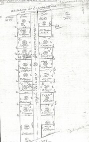
Map, Subdivision Plan of residential allotments in Munro Street, Ringwood, Victoria - (Undated, circa 1920s)
... Subdivision Plan of residential allotments in Munro Street... backing. Subdivision Plan of residential allotments in Munro ...Map of residential allotments on cardboard backing.Handwritten notations include sales information and title references LP1884, Vol 6602, Fol 132038, with number of units on lots 8, 9 and 10. -
 Ringwood and District Historical Society
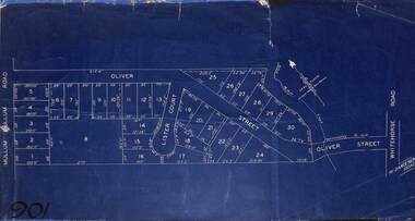
Map, Subdivision Plan of residential allotments in Mullum Mullum Road, Oliver Street and Lister Court, Ringwood, Victoria - (Undated)
... Subdivision Plan of residential allotments in Mullum Mullum... Subdivision Plan of residential allotments in Mullum Mullum Road ...Blueprint copy on cardboard backingNorth directional indicator includes name of Surveyor and Town Planner, Saxil Tuxen. -
 Ringwood and District Historical Society
Map, Subdivision Plan of residential allotments in Caroline Street, Thomas Street, Emerald Street and Ford Street, Ringwood, Victoria - (Undated, circa 1930)
... Subdivision Plan of residential allotments in Caroline... of residential allotments on blue cardboard backing. Subdivision Plan ...Map of residential allotments on blue cardboard backing.Handwritten title reference notation LP13641. -
 Ringwood and District Historical Society
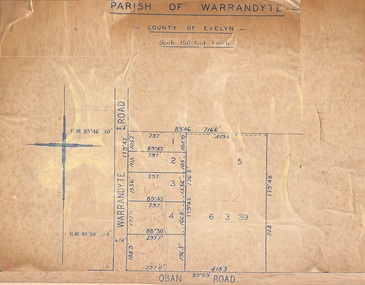
Map, Subdivision Plan of 5 residential allotments on Warrandyte Road and Oban Road, Ringwood, Victoria - (Undated - pre 1950s)
... Subdivision Plan of 5 residential allotments on Warrandyte... of Crown Allotment Map on cardboard backing Subdivision Plan of 5 ...Partial copy of Crown Allotment Map on cardboard backingParish of Warrandyte, County of Evelyn. -
 Ringwood and District Historical Society
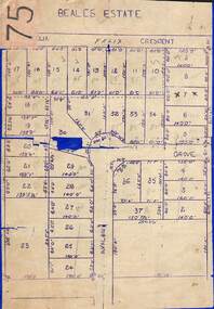
Map, Subdivision Plan of 37 residential allotments on Panorama Avenue, Felix Crescent, Evelyn Road and Avalon Grove, Ringwood, Victoria - (Undated - circa 1960)
... Subdivision Plan of 37 residential allotments on Panorama... backing Subdivision Plan of 37 residential allotments on Panorama ...Stencilled copy of map on blue cardboard backingBeales Estate -
 Greensborough Historical Society
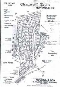
Plan, Coghill and Son, Glengarriff Estate Montmorency, 1938c
... Black and white photocopy of a real estate agent's plan... of a real estate agent's plan of subdivision Glengarriff Estate ...Plan for the Glengarriff Estate covers 171 lots in vicinity of Montmorency Railway Station, for private sale, controlling agents Coghill & Son, Local Agents Shallard Bros, Main Road Eltham. C/T 6068/1213512 formerly owned by George Nicholson, dentist.Black and white photocopy of a real estate agent's plan of subdivision montmorency, glengarriff estate montmorency, calrossie street montmorency -
Glenelg Shire Council Cultural Collection
Plan - Plans - Cape Bridgewater Subdivision, n.d
... Two identical photocopies of old plan of subdivision... of old plan of subdivision at Cape Bridgewater Plan Plans - Cape ...Two identical photocopies of old plan of subdivision at Cape Bridgewater -
Whitehorse Historical Society Inc.
Document, Canterbury Road estate, Unknown
... Plan of subdivision of land for sale in Canterbury Road... street ronley street eustace street Plan of subdivision of land ...Plan of subdivision of land for sale in Canterbury Road estate, Blackburn.land subdivision, canterbury road estate, blackburn, main street, norvel street, kalka street, arna street, lalwa street, ronley street, eustace street -
 Ringwood and District Historical Society
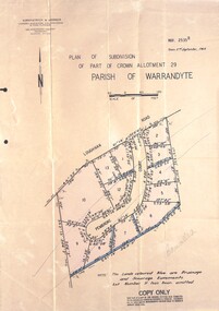
Document - Folder, Pembroke Estate Subdivsion, Ringwood, Victoria - 1964
... Manilla folder containing certified copy of Plan... Carter - Carter Real Estate - "Vendor - Dale, Plan of Subdivision... Carter - Carter Real Estate - "Vendor - Dale, Plan of Subdivision ...Manilla folder containing certified copy of Plan of Subdivision dated 2nd September, 1964 - Part of Crown Allotment 29 Parish of Warrandyte, and separate A4 size copy of plan with handwritten 1966 pricing notations. Subdivision includes allotments on Pembroke Court off Loughnans Road, Ringwood.Surveyors - Kirkpatrick & Webber, Civil Engineers & Town Planners, 225 Maroondah Highway, Ringwood, Telephone 8700321. Agents - C.E. Carter & Son RESI., 126 Whitehorse Road, Ringwood (Phone) 87-6024, 87-6830, 870-2519. Folder covernote by Richard Carter - Carter Real Estate - "Vendor - Dale, Plan of Subdivision 68868, sold 23 July 1966." -
Ringwood and District Historical Society
Pamphlets, N.R. Reid & Co Pty Ltd, Subdivision pamphlet Hunter Estate Ringwood, 1959
... Bifold pamphlet green black and white printing, plan... printing, plan of subdivision on second page Subdivision pamphlet ...The Hunter Estate, from Wonga Road to Mullum Mullum Road including Panfield Avenue, Hunter Avenue and Hendra Grove.Bifold pamphlet green black and white printing, plan of subdivision on second page -
Whitehorse Historical Society Inc.
Map, Plan, 1939
... Plan of subdivision, part of crown portion 83A and 83... Linum Street Blackburn Plan of subdivision, part of crown ...Plan of subdivision, part of crown portion 83A and 83, Parish of Nunawading, County of BourkePlan of subdivision, part of crown portion 83A and 83, Parish of Nunawading, County of BourkePlan of subdivision, part of crown portion 83A and 83, Parish of Nunawading, County of Bourkestreet names, parish of nunawading, station street, blackburn, railway road, blackburn, vine street, blackburn, south parade, blackburn, laburnum street, blackburn, main street, blackburn, gardenia street, blackburn, the avenue, blackburn, fuschia street, blackburn, linum street, blackburn -
 Kew Historical Society Inc
Plan - Subdivision Plan, J R Mathers & McMillan, Myrtle Hill Estate, East Kew, circa 1949, c.1949
... Subdivision Plan... a substantial number of real estate subdivision plans, mainly of Kew.... The subdivision plan of the ‘Myrtle Hill Estate’ indicates that in one...The full (typed) title of this subdivision plan is :"Plan... number of real estate subdivision plans, mainly of Kew but also ...The Kew Historical Society's map collection includes a substantial number of real estate subdivision plans, mainly of Kew but also of surrounding suburbs in Melbourne. Most of the subdivision plans date from the 1920s and 1930s when the districts old homes and local farmland were being split up to accommodate residential growth in the postwar period. These early plans were assembled by a local firm, Jas R Mather & McMillan, which had an office in Cotham Road. Many of the plans, and sometimes photos, were annotated by the agents.Subdivision plans are historically important documents used as evidence for the growth of suburbs in Australia. They frequently provide information about when the land was sold as well as evidence relating to surveyors and real estate and financial agents. The numerous subdivision plans in the Kew Historical Society's collection represent working documents, ranging from the initial sketches made in planning a subdivision to printed plans on which auctioneers or agents listed the prices for which individual lots were sold. In a number of cases, the reverse of a subdivision plan in the collection includes a photograph of a house that was also for sale by the agent. These photographs provide significant heritage information relating house design and decoration, fencing and household gardens.The photograph may also be aesthetically significant depending on the importance of the photographic atelier.Myrtle Hill, at 14 Vista Avenue, Kew, is of local historical and architectural significance as a good example of a large and imposing single-storey Italianate house of the early 1870s surviving in Kew. Originally sited on a large allotment overlooking Normanby Road, the setting of the house has been dramatically altered through extensive subdivision and development. The subdivision plan of the ‘Myrtle Hill Estate’ indicates that in one such subdivision, 11 allotments were created fronting Bowyer Avenue, Myrtle Avenue, and Normanby Road. The outline and building profile of Myrtle Hill is shown on the west side of Bowyer Avenue.The full (typed) title of this subdivision plan is :"Plan of SUBDIVISION of part of CROWN PORTION 83. / at KEW / PARISH OF BOROONDARA. / COUNTY OF BOURKE". / "MYRTLE HILL ESTATE / EAST KEW" In addition to the Title and subtitle, the plan also lists the advantages of the subdivision. -
Whitehorse Historical Society Inc.
Map, Aspinall's old abattoirs, Box Hill, 1937
... Hand drawn plan of subdivision of old abattoirs site... drawn plan of subdivision of old abattoirs site, Woodhouse Grove ...Hand drawn plan of subdivision of old abattoirs site, Woodhouse Grove, Box Hill North.Hand drawn plan of subdivision of old abattoirs site, Woodhouse Grove, Box Hill North.Hand drawn plan of subdivision of old abattoirs site, Woodhouse Grove, Box Hill North.land subdivision, aspinall's estate, woodhouse grove, box hill north, aspinall road, box hill north, abattoirs -
 Whitehorse Historical Society Inc.
Document, Metropolitan Avenue, n.d
... Plan of subdivision of 321.162 and 321.163 Metropolitan.... tolson horan william southey land subdivision Plan of subdivision ...Plan of subdivision of 321.162 and 321.Plan of subdivision of 321.162 and 321.163 Metropolitan Avenue between Whitehorse (or Lilydale) Road and the railway in Nunawading.Plan of subdivision of 321.162 and 321.metropolitan avenue, nunawading, fargher, j.j., bond, j., bell, k., anderson, g., blackman, r., skinner, t., westwall, m., goodwin, george augustus, cornwall, i., hesketh, henderson, e., timms, m.a., tolson, horan, william, southey, land subdivision -
 Whitehorse Historical Society Inc.
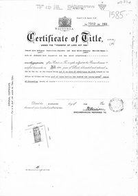
Document, Certificate of Title, 1/06/1951
... of Subdivision No 6626, 50 Burnett Street, Mitcham, with Plan..., being Lot 72 on Plan of Subdivision No 6626, 50 Burnett Street ...Certificate of Title Vol 7583 Fol 060, being Lot 72 on Plan of Subdivision No 6626, 50 Burnett Street, Mitcham, with Plan of Subdivision No 6626 including Burnett Street, Thomas Street, bordered by Cook Street and Cook Street and Whitehorse Road, Mitchamburnett street, mitcham, no 50, thomas street, cook road, whitehorse road -
Whitehorse Historical Society Inc.
Map, Lake Road estate Blackburn, c1960
... Plan of subdivision of Lake Road Estate, 36 sites. Agent... Anjaya Court Blackburn Leons Court Blackburn Plan of subdivision ...Plan of subdivision of Lake Road Estate, 36 sites.Plan of subdivision of Lake Road Estate, 36 sites. Agent: Mark Padgett & Co Pty Ltd.Plan of subdivision of Lake Road Estate, 36 sites. lake road estate, blackburn, lake road, blackburn, ottawa avenue, blackburn, anjaya court, blackburn, leons court, blackburn -
Whitehorse Historical Society Inc.
Legal record - Land Title, Musk Street, Blackburn
... Rogers, 1955, with Plan of Subdivision CP 21670; 5. cadastral..., with Plan of Subdivision CP 21670; 5. cadastral map, AMA zone 55... Henry Rogers, 1955, with Plan of Subdivision CP 21670; 5 ...Land Titles referring to No. 1 Musk Street, BlackburnLand Titles referring to No. 1 Musk Street, Blackburn : 1. Vol. 542 Fol. 108222, James William Barnes, 1872; 2. Vol. 1877, Fol. 375367, Freehold Investment and Banking Company of Australia Limited, 1886; 3. Transfer 1507851 to John Thomas Williams, 1932; 4. Vol. 8109 Fol. 997 William Henry Rogers, 1955, with Plan of Subdivision CP 21670; 5. cadastral map, AMA zone 55, Sep 2000.Land Titles referring to No. 1 Musk Street, Blackburn musk street, blackburn, no. 1, maple street, blackburn, lawson street, blackburn, elder street, blackburn, barnes, james william, freehold investment and banking company of australia ltd, springfield road, blackburn, whitehorse road, blackburn, barnes estate