Showing 179 items
matching sandhurst maps
-
 Bendigo Historical Society Inc.
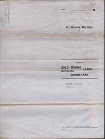
Document - MCCOLL, RANKIN AND STANISTREET COLLECTION: CENTRAL NAPOLEON GOLD MINING CO. N.L, 15th December 1934
Document: Gold Mining Lease Crown Land, No 10260 Bendigo, Entered in the register book vol. 307 fol. 34041, embossed seals of Central Napoleon Gold Mining Co N.L. & King George V, Map: No 10260, Mining district of Bendigo, Parish of Sandhurst, County of Bendigo, During the Reign of King George V.organization, business, industry - mining, mccoll rankin & stanistreet, mining, gold mining, central napoleon -
 Bendigo Historical Society Inc.
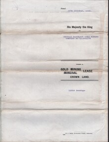
Document - MCCOLL, RANKIN AND STANISTREET COLLECTION COLLECTION: CENTRAL NAPOLEON GOLD MINING CO. N.L, 30th October 1939
Document: Gold Mining Lease crown Land No 11016 Bendigo, Entered in the register book Vol. 324 fol. 35754, Embossed seals of Central Napoleon Gold Mining Co N.L. and Kin g George VI, Map: Mining District of Bendigo, County of Bendigo, Parish of Sandhurst, located at Harvey & Inglis Streets, During the reign of King George VI (document orignally had Edward VIII).organization, business, industry - mining, mccoll rankin & stanistreet, mining, gold mining, central napoleon -
 Bendigo Historical Society Inc.
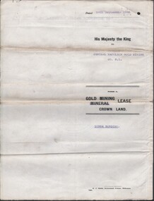
Document - MCCOLL, RANKIN AND STANISTREET COLLECTION COLLECTION: CENTRAL NAPOLEON GOLD MINING CO. N.L, 26th September 1938
Document: Gold Mining Lease Crown Land No. 10964 Bendigo, Entered in the register books, Vol. 322 Fol. 33571, Embossed seals of Central Napoleon and King George VI, Map: Mining District of Bendigo, County of Bendigo, Parish of Sandhurst, located at Harvey and Inglis Streets, During the reign of King George VI (Originally marked Edward VIII).organization, business, industry - mining, mccoll rankin & stanistreet, mining, gold mining, central napoleoon -
 Bendigo Historical Society Inc.
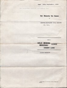
Document - MCCOLL, RANKIN AND STANISTREET COLLECTION: CENTRAL NAPOLEON GOLD MINING CO. N.L, 22nd June 1954
Document :Form A, Gold Mining Lease Crown Land 11314 Bendigo, Entered in the Register Book, Vol. 333 Fol. 138, Embossed seals of Central Napoleon and King George VI, Map: Mining District of Bendigo County of Bendigo Parish of Sandhurst, During the reign of Queen Elizabeth II, 4 pages.organization, business, industry - mining, mccoll rankin & stanistreet, mining, gold mining, central napoleon -
 Bendigo Historical Society Inc.
Map - SANDHURST (PART), Circa 1880's
... Inc. History House 11 Mackenzie Street Bendigo goldfields MAP ...Map: Parish plan showing an area from McKenzie/View streets to Long Gully ( number 232 in Map Cupboard 1)map, bendigo, parish plan, sandhusrt, mckenzie street , view street, long gully -
Bendigo Historical Society Inc.
Map - CITY OF SANDHURST RESURVEY SHEET 2, 23/05/1881
... Map City of sandhurst Resurvey, sheet 2. Parish plan... Bendigo parish plan Sandhurst Resurvey Map City of sandhurst ...Map City of sandhurst Resurvey, sheet 2. Parish plan ( number 231 in Map Cupboard 1)map, bendigo, parish plan, sandhurst resurvey -
Bendigo Historical Society Inc.
Map - SANDHURST (PART), Circa 1880's
... in Map Cupboard 1) Map SANDHURST (PART) ...Map: Parish plan covering the area from Belle Vue Rd. to Barnard St. and Maple St to Short St. ( number 230 in Map Cupboard 1)map, bendigo, parish plan, sandhurst, belle vue road, barnard street, maple street , short street -
Bendigo Historical Society Inc.
Map - CITY OF SANDHURST SHEET NO.6, 25/04/1882
... Map: City of Sandhurst sheet No. 6. Parish plan... Bendigo parish plan Sandhurst Map: City of Sandhurst sheet No. 6 ...Map: City of Sandhurst sheet No. 6. Parish planmap, bendigo, parish plan, sandhurst -
Bendigo Historical Society Inc.
Map - CITY OF SANDHURST RESURVEY SHEET NO. 3, 13/05/1881
... Map: City of Sandhurst Resurvey sheet No. 3. Parish plan.... Bendigo parish plan Sandhurst Resurvey Map: City of Sandhurst ...Map: City of Sandhurst Resurvey sheet No. 3. Parish plan.map, bendigo, parish plan, sandhurst, resurvey -
Bendigo Historical Society Inc.
Map - SANDHURST (PART), Circa 1880's
... Bendigo parish plan Sandhurst Charleston Road Lloyd street Map ...Map: Parish plan showing Charleston Rd. Lloyd St. areamap, bendigo, parish plan, sandhurst, charleston road, lloyd street -
Bendigo Historical Society Inc.
Map - CITY OF SANDHURST SHEET NO 4, 25/04/1882
... Map: City of sandhurst sheet No. 4. Parish plan ( number... Bendigo parish plan Sandhusrt Map: City of sandhurst sheet No. 4 ...Map: City of sandhurst sheet No. 4. Parish plan ( number 224 in Map Cupboard 1)map, bendigo, parish plan, sandhusrt -
Bendigo Historical Society Inc.
Map - CITY OF SANDHURST SHEET NO. 5, 18/04/1882
... Map: City of sandhurst sheet No. 5. Parish plan ( number... Bendigo parish plan Sandhusrt Map: City of sandhurst sheet No. 5 ...Map: City of sandhurst sheet No. 5. Parish plan ( number 223 in Map Cupboard 1)map, bendigo, parish plan, sandhusrt -
Bendigo Historical Society Inc.
Map - SANDHURST (PART), Circa 1880's
... . ( number 222 in Map Cupboard 1) Map SANDHURST (PART) ...Map: Parish plan showing the area Specimen Hill Road and Inglewood St. ( number 222 in Map Cupboard 1)map, bendigo, parish plan, specimen hill rd. inglewood st. -
Bendigo Historical Society Inc.
Map - BENDIGO (SANDHURST) PART, No date visible
... Gully ( number 220 in Map Cupboard 1) Map BENDIGO (SANDHURST ...Map: Parish plan showing an area North West from the McKenzie St. View St. corner to Long Gully ( number 220 in Map Cupboard 1)map, bendigo, parish plan, bendigo, long gully -
Bendigo Historical Society Inc.
Map - SANDHURST (PART), Circa 1880's
... Bendigo parish plan Lloyd St. Sandhurst Bendigo Map: Parish plan ...Map: Parish plan showing a section of the city of Sandhurst, Northwards from Lloyd St. East bendigo. ( number 212 in Map Cupboard 1)map, bendigo, parish plan, lloyd st. sandhurst, bendigo -
Bendigo Historical Society Inc.
Map - SANDHURST (PART), Circa 1880's
... Bendigo parish plan Specimen Hill Rd. Sandhurst Bendigo Map ...Map: Parish plan sowing an area along Specimen Hill Rd. ( number 211 in Map Cupboard 1)map, bendigo, parish plan, specimen hill rd. sandhurst , bendigo -
 Bendigo Historical Society Inc.
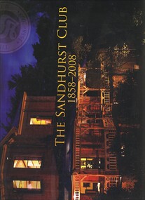
Book - THE SANDHURST CLUB 1858 - 2008, 2008
... BENDIGO Clubs sandhurst club Bendigo - History Sandhurst Club ...The Sandhurst Club 1858 - 2008, the history of the Sandhurst Club 101 pages published by The Sandhurst Club Bendigo with photographs, illustrations & maps.Geoff Russellbendigo, clubs, sandhurst club, bendigo - history, sandhurst club, promininet people. -
 Bendigo Historical Society Inc.
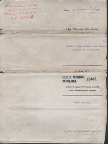
Document - MCCOLL, RANKIN AND STANISTREET COLLECTION: CENTRAL NELL GWYNNE - FORM D GOLD MINING LEASE 10981 BENDIGO, 5 Oct 1936
Document. Renewal New Lease no 11073 His Majesty the King to Central Nell Gwynne GMC N/L. 1 map no 10981 of Mining District of Bendigo Parish of Sandhurst City of Bendigo County of Bendigo. No 10981 Bendigo Vo 322 Fol 35594.McColl, Rankin & Stanistreetorganization, business, central nell gwynne, mccoll, rankin & stanistreet, cnetral nell gwynne, gold mining, lease -
 Bendigo Historical Society Inc.
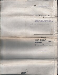
Document - MCCOLL, RANKIN AND STANISTREET COLLECTION: CENTRAL NELL GWYNNE, 5/10/1941
Document. Paper Document containing an indenture detailing lease between His Majesty the King to Central Nell Gwynne Gold Mining Company No Liability. Included is a map of the mining district of Bendigo Parish of Sandhurst. No 11172 Bendigo Vol 327 Fol 36016.McColl, Rankin & Stanistreetorganization, business, central nell gwynne, mccoll, rankin & stanistreet, central nell gwynne, gold mining, lease -
 Bendigo Historical Society Inc.
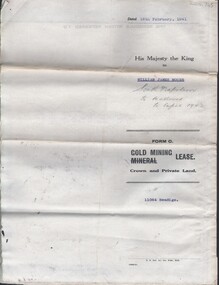
Document - MCCOLL, RANKIN AND STANISTREET COLLECTION: NAPOLEON REEF GOLD MINING CO. N.L, 18 Feb 1941
Document: 4 Page legal document with map of lease area issued to William James Moore of Bendigo, Lease No. 11064 Bendigo, Vol. 325 Fol. 35881 County of Bendigo Parish of Sandhurst, 15 year lease from 18th February 1941, in vacinity of Curnow St, Booth St, Maple St and Rowan Sts, Lease by South Napoleon to be allowed to lapse in 1942, signed by Major General Sir Winston Joseph Dugan Governor of Victoria, William James Moore & witnessed by Walsh, Wardens Clerk Bendigo.organization, business, industrial - mining, mccoll rankin & stanistreet, mining, gold mining, napoleon reef -
Bendigo Historical Society Inc.
Map - SANDHURST, Circa 1906
... Map: Parish of Sandhurst, County of Bendigo. Parish plan... Bendigo parish plan Sandhurst Map: Parish of Sandhurst, County ...Map: Parish of Sandhurst, County of Bendigo. Parish planmap, bendigo, parish plan, sandhurst -
Bendigo Historical Society Inc.
Map - BENDIGO, issued 1st January 1906
Map: Sketch map of Bendigo, including Eaglehawk and the Parish of Sandhurst. Issued by the Fire Underwriters Association of Victoria. Revised copy (number 317 in map cupboard 1)map, bendigo, city streets, map of bendigo, fire underwriters association of victoria -
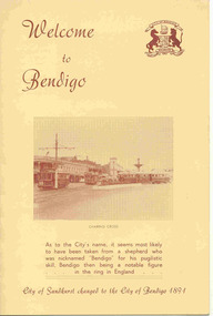 Ballarat Tramway Museum
Pamphlet, Royal Historical Society of Victoria (Bendigo and District Branch), "Welcome to Bendigo" / "Evolution of Bendigo Tramways", 1960's
Four page, heavy manila coloured card - 200 gsm, scored and folded, sepia toned pamphlet titled "Welcome to Bendigo" / "Evolution of Bendigo Tramways". On front cover has a photo taken early 1960's of four trams at Charing Cross, the name of Bendigo, change of name from Sandhurst. Inside pages features 1890 Bendigo, 1903 California combination, 1945 Maximum Traction bogies, 1892 steam tram, 1913 open cross bench trams and 1947 Birney safety cars. On rear has map of Bendigo, and a list of places of interest. Has the crest of the City of Bendigo on the front cover.trams, tramways, bendigo, steam trams, battery trams -
 Bendigo Historical Society Inc.
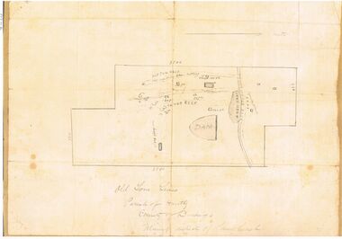
Map - OLD TOM MINE, WHIPSTICK
... BENDIGO Mining old tom lease map 2 copies ( A4 and A3) of Old Tom ...2 copies ( A4 and A3) of Old Tom lease. Map shows Old Tom Reef, old working open cutting, shaft 150 ft., Easter Reef, dam sand heap, water race, 3 other shafts, 120ft., 90ft., and 500 ft. marked on map. Stamped on map '64.3.34' Written on bottom of map in handwriting ' Old Tom Lease, Parish of Huntly, County of Bendigo, Mining district of Sandhurst'bendigo, mining, old tom lease map -
 Bendigo Historical Society Inc.
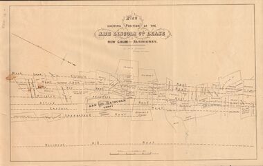
Document - MARKS COLLECTION: ABE LINCOLN CO LEASE
Two copies of plan for Abe Lincoln Co. Lease, New Chum, Sandhurst. One original, one copy. On top of plan 'Plan Showing Position of the Abe Lincoln Co. Lease, New Chum, Sandhurst' under name 'by H.B. Nicholas, Mining Surveyor' Sheepshead Reef, Easter reef, Alfred Reef, Allingham Reef,Adventure Reef, Belle Vue Reef, New Chum Reef, Black Lead, Victoria Reef lines shown on map with mine leases marked. On bottom of map 'Monument Hill Reef' line marked.bendigo, mining, abe lincoln lease -
 Bendigo Historical Society Inc.
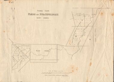
Document - MARKS COLLECTION: MAP OF PARISH OF STRATHFIELDSAYE 1858, 8th September, 1858
Buff coloured document. On top 'Country Lands, Parish of Strathfieldsaye, County Unnamed'. On bottom 'Scale 40 chains to an inch. Public Lands Office, Melbourne Sept 8th. 1858. William Collis, Lith ( lithographer )'. Map shows Village Reserve on Emu Creek, road from Sandhurst, Sheepwash Creek and Splitters Creek. Wellington Hotel marked on map near intersection of Sheepwash Creek, Axe Creek and Emu Creek. Axe Creek Pound near Splitters Creek.map, bendigo, parish of strathfieldsaye 1858 -
 Bendigo Historical Society Inc.
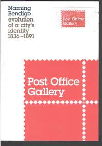
Book - NAMING BENDIGO: EVOLUTION OF A CITY'S IDENTITY 1836 TO1891
Red and white covered booklet titled 'Naming Bendigo evolution of a city's identity 1836 - 1891. It has a sketch map of Bendigo and Golden Square in 1851. It has a number of photos of early paintings, postcards and objects. The Foreword is written by Cr Rod Campbell, Mayor of the City of Greater Bendigo and the Introduction is written by Karen Quinlan, Director. The chapters are titled: Naming Bendigo evolution of a city's identity 1836 - 1891; The Gibson brothers soon renamed the run a popular choice in the 19th century; and to direct that the said place shall be called and known as Sandhurst; endeavoured to ascertain from what source, and at what time, the name of Bendigo arose: "The diggers...at Bendigo are recherché as to names;" and the Exhibition Checklist.event, exhibition, naming bendigo, naming bendigo - evolution of a city's identity 1836-1891, post office gallery, bendigo art galery, studio round, bambra, sandra bruce, karen quinlan, ian hill, national library of australia, city of greater bendigo, elaine harrington, vic lane, reg and judy macdonald, dennis o'hoy, sandhurst trustees, phil wilkins, darren wright, eaglehawk, eppalock, epsom, flora hill, golden square, kangaroo flat, strathfieldsaye, mount alexander run (north, or no 2 - ravenswood run -
 Bendigo Historical Society Inc.
Document - Chinese Distribution in Eaglehawk and Sandhurst in 1861
Chinese Distribution in Eaglehawk and Sandhurst in 1861. Sketch and Map of the Chinese showing their population based on the census.history, bendigo, eaglehawk, chinese, sandhurst -
Bendigo Historical Society Inc.
Map - NERRING : COUNTY OF BENDIGO, August 1952
Map. Nerring, County of Bendigo, Leichardt, Marong, Sandhurst, Huntly, Neilborough, Yarraberb. Drawn and Reproduced at the Department of Lands and Survey, Melbourne, Victoria, August 1952, Price 2/-.( number 409 in Map Cupboard 1).J.J. Gourley, Government Printer, Melbourne.bendigo, hospital -
 Bendigo Historical Society Inc.
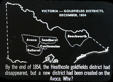
Slide - DIGGERS & MINING. THE GOLD LICENCE, c1854
Diggers & Mining. The gold licence. The Government Camp. Slide depicts map of Victoria with the 5 gold rush regions marked on it. Beechworth, Sandhurst Avoca, Castlemaine and Ballarat. By the end of 1854, the Heathcote goldfields district had disappeared, but a district had been created on the Avoca. Why? Markings: 31 994.LIF. 4. Used as a teaching aid.hanimounteducation, tertiary, goldfields