Showing 532 items matching "scenic"
-
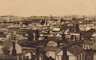
 Clunes Museum
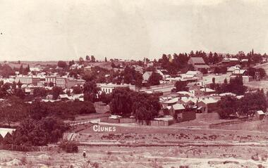
Photograph, 1911
COPY OF POSTCARD OF TOWNSHIP OF CLUNES 1911, TAKEN FROM SCENIC DRIVE, SHOWING FRASER STRRET BUILDINGS, ST PAUL'S CHURCH ETC.CLUNESlocal history, document, postcard, clunes township -
 Bendigo Historical Society Inc.
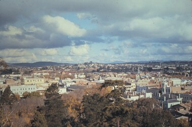
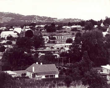
Slide - BENDIGO VIEWS, May 1961
Slide. Bendigo Views. Scenic view of Bendigo. A building on the left has 'Maples' painted on the side. Maples is currently Bendigo Toyworls in Mitchell Street.slide, bendigo, bendigo views, bendigo views -
 Bendigo Historical Society Inc.
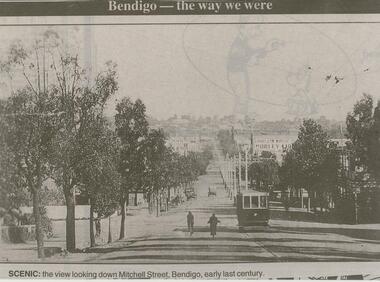
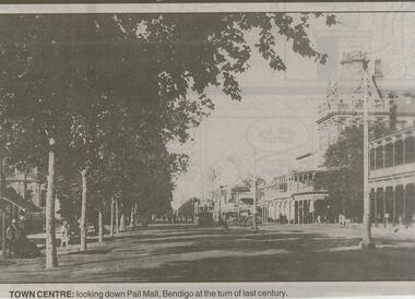
Newspaper - JENNY FOLEY COLLECTION: SCENIC
Bendigo Advertiser ''The way we were'' from 2000. Scenic: the view looking down Mitchell Street, Bendigo, early last century. The clip is in a folder.newspaper, bendigo advertiser, the way we were -
 Bendigo Historical Society Inc.
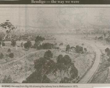
Newspaper - JENNY FOLEY COLLECTION: SCENIC
Bendigo Advertiser ''the way we were'' from 2000. Scenic: the view from Big Hill showing the railway line to Melbourne in 1875. The clip is in a folder.newspaper, bendigo advertiser, the way we were -
 Bendigo Historical Society Inc.
Photograph - NEW CHUM GULLY, c.1900
Black and white photograph of New Chum Gully. Scenic view of homes in foreground. Civic buildings, churches, mines in background. Photo possibly from a seriesplace, landscape view, new chum gully -
 Bendigo Historical Society Inc.
Slide - BENDIGO VIEWS, Dec 1960
Slide. Bendigo Views. Scenic view of Bendigo with a tall brick chimney near some large buildings. ADI, Australian Defence Industries now THALES.slide, bendigo, bendigo views, bendigo views -
 Clunes Museum
Letter, 1971
Correspondence from the Shire to the Committee on the current situation with the proposed caravan park for Clunes.CARBON COPY CORRESPONDENCE FROM SHIRE OF TALBOT & CLUNES, (TYPED) TO SECRETARY OF CARAVAN PARK AND SCENIC ROAD COMMITTEE OF CLUNES. DATED 6TH APRIL, 1971local history, document, letter, caravan park -
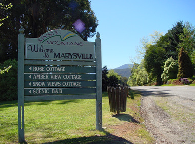 Marysville & District Historical Society
Photograph (Item) - Colour photograph, Unknown
A colour photograph of a sign welcoming visitors to Marysville in Victoria.A colour photograph of a sign welcoming visitors to Marysville in Victoria. The sign also directs visitors to four accommodation sites. The sign was located on Murchison Street near the entrance to Marysville. The sign and these accommodation sites, along with most of the businesses in Marysville, were destroyed in the 2009 Black Saturday bushfires.MYSTIC MOUNTAINS Welcome to MARYSVILLE ROSE COTTAGE AMBER VIEW COTTAGE SNOW VIEWS COTTAGE SCENIC B&Bmystic mountains, marysville, victoria, rose cottage, amber view cottage, snow views cottage, scenic b&b, photograph, 2009 black saturday bushfires -
Glenelg Shire Council Cultural Collection
Souvenir - China Dish - Portland Harbour, n.d
White, oval shaped china dish, scalloped edge, handle each end. In the middle centre of the dish is a colour image of Portland Harbour. 'PANORAMA OF THE HARBOUR, PORTLAND', in black beneath image.Back: Base: Red makers stamp & logo 'Royal Scenic China IBC MADE IN CZECHOSLOVAKIA' '620' faintly visible. portland harbour, souvenir, tourism, travel, portland -
 Southern Sherbrooke Historical Society Inc.
Advertisement, U.S. Motors, Belgrave
Black and white advertisement (postcard?) for U.S. Motors.'See the Blue Dandenongs...make this Magnificent Conducted Scenic Tour by Luxurious Motor Coach' with a photo of a tourist bus. -
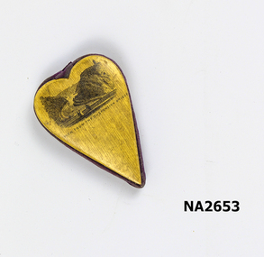 Whitehorse Historical Society Inc.
Souvenir - Heart shaped souvenir, 1870 - 1890
Heart shaped wood and velveteen souvenir. May have hung from a ribbon. Printed with a scenic view of river and high cliffs either side and a suspension bridge with figures in foreground.View from suspension bridgedomestic items, ornaments / decorative -
Clunes Museum
Document - HERITAGE PROJECT, 1988
COLLECTION TALBOT & CLUNES SHIRE BICENTENNIAL HERITAGE PROJECT COMMITTEE MEETINGS, REPORTS, HISTORIC GARDENS CONSERVATIONS FUND APPLICATION FORMS, BALANCE SHEETS, SCENIC BROCHURES AND COUNCIL ENVELOPESlocal history, documents, heritage project, talbot & clunes shire, bicentennial project -
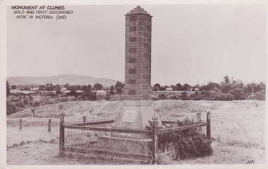 Clunes Museum
Photograph, MONUMENT
MONUMENT BUILT AND ERECTED ON SITE OF FIRST GOLD DISCOVERY IN VICTORIA 1851. PORT PHILLIP MINE.BLACK AND WHITE POSTCARD OF THE BRICK MONUMENT ON SCENIC DRIVE, SURROUNDED BY WOOD AND WIRE MESH FENCE WITH CAMP PARADE AND MOUNT BECKWORTH IN BACKGROUND. PLAQUE ON CEMENT BASE OF BRICK PILLAR.MONUMENT AT CLUNES. GOLD WAS FIRST DISCOVERED HERE IN VICTORIA 1851.photography, monuments, memorials& mining -
Glenelg Shire Council Cultural Collection
Photograph - Photograph - Shelly Beach, Cape Bridgewater, M. E. Andrews, n.d
Black and white photo of natural rock arch at Shelly Beach, Cape Bridgewater.Back: 'Scenic Arch Shelley Beach Cape Bridgewater' - handwritten in black ink Round purple stamp 'PRINTED BY M.E. ANDREWS PORTLAND'cape bridgewater, shelly beach, beach photography, seascape, rock formation -
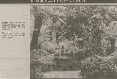 Bendigo Historical Society Inc.
Newspaper - JENNY FOLEY COLLECTION: LUSH
Bendigo Advertiser ''The way we were'' from 2000. Lush: the fernery in Rosalind Park gives Bendigo a taste of the rainforest. The scenic location was captured on film in the early 1900s. The clip is in a folder.newspaper, bendigo advertiser, the way we were -
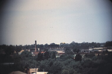
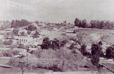 Clunes Museum
Photograph
PHOTOCOPY OF PHOTOGRAPH OF CLUNES LANDSCAPE TAKEN FROM SCENIC ROAD, BRIDGE IN RIGHT FOREGROUND, ANZ BANK IN CENTRE GROUND, TEMPLETON STREET AND TALBOT MINE CENTRE RIGHT [CENTRAL CLUNES MINE?]local history, photography, photographs, clunes landscape + buildings -
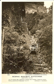 Bendigo Historical Society Inc.
Photograph - BASIL MILLER COLLECTION: SCENIC RAILWAY - KATOOMBA N.S.W
Two black and white photographs of the scenic railway located at Katoomba N.S.W. Inscriptions: Number 503 on front of one and 496 on other. They both have the same inscriptions on front; Copyright. A. Manning Katoomba, Scenic Railway Katoomba, Blue Mountains N.S.W. Grade at this point52 degrees for a distance of 181 feet (503). 1200 feet from the top showing grade and tunnel through rock (496). Total length of railway 1300 feet at an average gradient of 45 degrees.person, individual, basil miller -
 Bendigo Historical Society Inc.
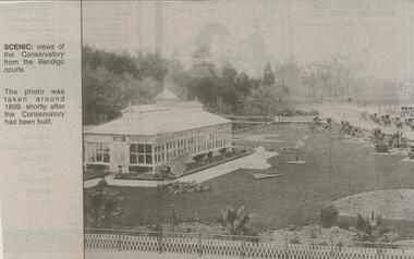
Newspaper - JENNY FOLEY COLLECTION: SCENIC
Bendigo Advertiser ''The way we were'' from 2000. Scenic: views of the Conservatory from the Bendigo courts. The photo was taken around 1899, shortly after the Conservatory had been built. The clip is in a folder.newspaper, bendigo advertiser, the way we were -
 Clunes Museum
photograph, 1967
BLACK AND WHITE PHOTOGRAPH OF CLUNES TOWNSHIP TAKEN CIRCA 1967. PHOTOGRAPH TAKEN FROM SCENIC ROAD FACING SOUTH, BUILDINGS INCLUDE POST OFFICE, METHODIST CHURCH, ST. THOMAS PRESBYTERY ETC.local history, photography, photographs, clunes township -
 Lakes Entrance Historical Society
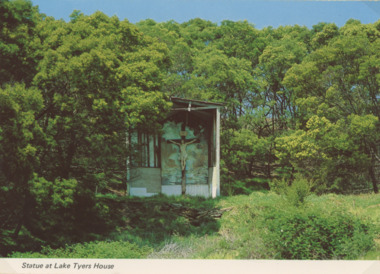
Photograph - Lake Tyers House, NU Color Vve, 1970c
Postcard was Produced for sale by Lake Tyers Scenic Boat TripsColour postcard of crucifix statue in grotto surrounded by scrub and timber Lake Tyers House Lake Tyers VictoriaStatue at Lake Tyers Housejetties, waterways -
Clunes Museum
Document, MINUTES FOR PUBLIC MEETING HELD IN THE TOWN HALL CLUNES ON 23/2/1971, 23/02/1971
THIS PUBLIC MEETING WAS TO CONSIDER THE FOLLOWING; HOLDING OF A "BACK TO CLUNES", CONSTRUCTION OF A CARAVAN PARK AND CONSTRUCTION OF A SCENIC TOURISE ROAD FROM ANGUS STREET TO FRASER STREET VIA "THE ROCKS" THIS RESULTED IN THE ELECTION OF A "BACK TO CLUNES" COMMITTEE AND THE" SCENIC ROAD AND CARAVAN PARK COMMITTEE".2 X FOOLSCAP PAGES OF THE COPY OF MINUTES HELD IN THE TOWN HALL, CLUNES ON 23/2/1971local history, local government, council, events and celebrations, back to clunes, scenic road and caravan park committee -
 Bendigo Historical Society Inc.
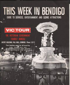
Document - VIC TOUR BROCHURE - THIS WEEK IN BENDIGO 25/08/1969
VIC TOUR brochure THIS WEEK IN BENDIGO Guide to entertainment and Scenic Attractions Two sheet, eight page paper brochure Lists entertainment, visitor attractions/sites and events for the week commencing 25/08/69Government Printer, Melbourne -
 Bendigo Historical Society Inc.
Newspaper - JENNY FOLEY COLLECTION: SCENIC
Bendigo Advertiser ''The way we were'' from 2000. Scenic: Lake Weeroona has always been a tranquil place for people to picnic and relax or alternately use the cycle path and enjoy water activities. The clip is in a folder.newspaper, bendigo advertiser, the way we were -
 Melbourne Water
Photographic View Book, The Melbourne & Metropolitan Board of Works - Water Supply, Sewerage etc. ...Photographic Views, 1908
In 1891 The Melbourne and Metropolitan Board of Works (MMBW) was formed and became responsible for Melbourne's water supply. Melbourne had grown to a city of half a million people. To provide water to this rapidly growing city (especially the eastern suburbs), and to supplement the 1857 Yan Yean Reservoir, Melbourne's first water supply, the Watts River (near Healesville) was tapped. It supplied water to Melbourne, via the Maroondah aqueduct. In May 1892 the MMBW's first engineer-in-chief, Mr William Thwaites began construction on Melbourne's sewerage system. A treatment farm was built at Werribee and a pumping station was built at Spotswood (now the site of the Scienceworks Museum) to send the city's waste to Werribee. The first Melbourne homes were connected to the sewerage system in 1897. This book showcases the MMBW's infrastructure achievements and documents costs, requirements and key personnel involved in the development of the water supply and sewerage schemes.The introduction states "The water supply sources and headworks are in many cases situated in remote places and the sewerage works are chiefly underground. The Board has therefore resolved that these photographs of some of the scenes and works should be collected and bound for general information. August 1908" This book is in excellent condition and provides a detailed insight into the previous 17 years of work and the Board personnel of the MMBW leading up to 1908. It is of historical importance to the history of Melbourne for the photographic documents of places that were not generally open to the public, and for Melbourne Water in its detailed history of the MMBW in the early twentieth century. Photographic view book with hard khaki coloured cardboard cover and blue fabric binding. 120 Pages. Glossy paper with black and white plates and text about the MMBW, and scenic views and places of interest in association with the MMBW. The Melbourne & Metropolitan Board of Works - Water Supply, Sewerage etc. ...Photographic Views...mmbw, board members, sewerage, water supply, historic views, photographs -
 Bendigo Historical Society Inc.
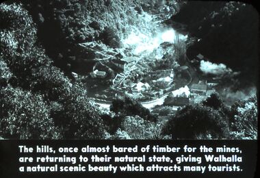
Slide - DIGGERS & MINING. DIGGERS AND MINERS, c1850
Diggers & Mining. Diggers and Miners. The hills, once almost bores of timber for the mines, are returning to their natural state, giving Walhalla a natural scenic beauty which attracts many tourists. Markings: 61 994.5 WAL. Used as a teaching aid.hanimounteducation, tertiary, goldfields -
 Bendigo Historical Society Inc.
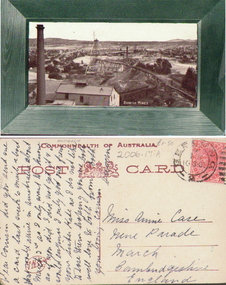
Photograph - VIEW OF BENDIGO MINES, c.1905
Black and white postcard photograph of scenic view labelled 'Bendigo Mines' including building, poppet head, chimney, trestle way, hills in background. Small letter on back. Inscriptions: 'Bendigo Mines'. On back - letter to Miss Annie Case.place, mining site -
 Ithacan Historical Society
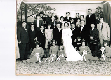
Photograph, Wedding group
The photos taken to celebrate the wedding of Marina and Iaokeim (James) Megalogennis. A black and white studio photograph of a large wedding group of the bride and groom with three bridesmaids, two flower girls, groomsmen and family members. The family members cover three and possibly four generations. The group have been photographed against a scenic backdrop. -
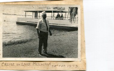 Kiewa Valley Historical Society
Photographs x 3- Cruise on Lake Mulwala, 25/2/1973
Lake Mulwala is a man–made reservoir created through the construction of the Yarrawonga Weir across the Murray River, is located between Bundalong and Yarrawonga in Hume region of Victoria and Mulwala in the Riverina region of New South Wales, in eastern Australia. The weir was constructed in 1939 to provide water for irrigation of the surrounding district. The weir also serves as a crossing of the Murray between the two towns. It is a popular tourist destination for boating, fishing and other water recreation.Photographs demonstrate local Kiewa Valley residents enjoying a visit to the picturesque area of Lake Mulwala. Also provides a pictorial history of 1973.3 black and white photographs mounted on buff card. Photographs of a cruise on Lake Mulwala 25th Feb. 1973 1. Photo of unidentified man standing on the shore of Lake Mulwala beside cruise launch. 2. Group photo of people standing by cruise boat as others disembark. Woman in centre holding handbag may be Clare Roper (unconfirmed) 3. Photo of 2 men aboard cruise launch looking out over Lake Mulwala1. Handwritten at bottom of photo in black ink. 'Cruise on Lake Mulwala. 25th Feb. 1973' 2. Painted sign above cruise launch- Scenic Lake Cruises 3. No markingsclare roper -
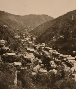 Ballarat Heritage Services
Photograph - Image - Black and White, Walhalla Looking North, c1903, c1903
Walhalla is a historic gold mining town nestled in a scenic valley in the Victorian Alps. It is named for the German hall of fame, the Walhalla temple,Sepia image of the Victorian goldtown Walhalla.walhalla, mining, townscape, gippsland -
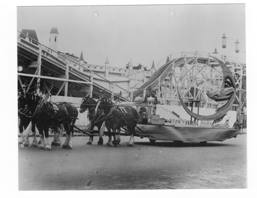 St Kilda Historical Society
Photograph, Luna Park, c. 1920
Amatuer photograph, Clydesdale horses drawing boat ride with moon in foreground, with entrance and Scenic Railway in the background Luna Park, St Kildablack and white photograph, unmounted, copy, fair condition