Showing 1046 items
matching shire services
-
 Eltham District Historical Society Inc
Negative - Photograph, J.A. McDonald, Sherbourne Road, Montmorency, c. July 1962
View looking west across Sherbourne Road to intersection of Rattray Road from present-day forecourt entrance to 7-Eleven Eltham service station The BP Service Station is now an Ampol Service Station (2022) Google Street View Apr.. 2022 https://goo.gl/maps/LM4APKCwj1ohBDPv5Record of various Shire of Eltham infrastructure works undertaken during the period of 1952-1962 involving bridge and road reconstruction projects, sometimes with Eltham Shire Council Project Reference numbers quoted. It was during this period that a number of significant improvements were made to roads and new bridges constructed within the shire that remain in place as of present day (2022). In many situations, the photos provide a tangible visible record of infrastructure that existed throughout the early days of the Shire. The album was put together by or under the direction of the Shire Engineer, J.A. McDonald.1962-07, ampol service station, bp service station, montmorency, rattray road, service station, sherbourne road, graders, infrastructure, public telephone box (red), reconstruction works, road construction, shire of eltham -
 Eltham District Historical Society Inc
Negative - Photograph, J.A. McDonald, Sherbourne Road, Montmorency, c. July 1962
View looking west across Sherbourne Road to intersection of Rattray Road from present-day forecourt entrance to 7-Eleven Eltham service station The BP Service Station is now an Ampol Service Station (2022) Google Street View Apr.. 2022 https://goo.gl/maps/LM4APKCwj1ohBDPv5Record of various Shire of Eltham infrastructure works undertaken during the period of 1952-1962 involving bridge and road reconstruction projects, sometimes with Eltham Shire Council Project Reference numbers quoted. It was during this period that a number of significant improvements were made to roads and new bridges constructed within the shire that remain in place as of present day (2022). In many situations, the photos provide a tangible visible record of infrastructure that existed throughout the early days of the Shire. The album was put together by or under the direction of the Shire Engineer, J.A. McDonald.1962-07, ampol service station, bp service station, montmorency, rattray road, service station, sherbourne road, infrastructure, reconstruction works, road construction, shire of eltham -
 Eltham District Historical Society Inc
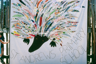
Slide - Photograph, St Andrews Primary School Banner, 1985
St Andrews Primary School was one of thirteen primary schools and one high school to participate in the banner project. A picture of the St Andrews Primary School banner was included in page 10 of The banner habits of the Eltham tribes : Eltham Shire "as we are" Community Banner Project report / by Jacky Talbot. The 'As We Are' Community Banner Project was the first major Community Arts project initiated and co-ordinated through the resources of the Shire of Eltham. It was originally conceived and inspired by a local textile artist, Tracey Naughton, who, together with the Community Services Manager of this local government council, made the idea a very concrete and flourishing reality. The project grew from the original fourteen or so intending participant groups to fifty-seven banners; expressions of those diverse groups' interests and identities. As a first major project it was rightly felt by Tracey Naughton, who became the Shire's first Community Arts Officer in March 1985, that it should be fully documented, so that an appraisal of the extensive growth of this community arts development process could be assessed. Given the time and money available to do this, Jacky Talbot, and her advisors, decided it was appropriate to select fifteen or twenty banners for detailed analysis. This was done by taping interviews with members of the chosen groups. The groups were chosen to cover all ages participating, from the toddlers in the Playhouse to our grand elder citizens in their Nursing Horne, and to cover a wide range of different types of groups - schools, scouts, churches, youth issue based, and the numerous women's groups of various combinations, localities and concerns. ·. Some groups who presented their banners for the culminating highlight of this project - the Exhibition, held at the Eltham Community Centre on October 9th, 1986, had no contact with the Shire or project co-ordinator, but heard about the project through the local news' networks or other participants. The extent of community participation was enormous. It involved hundreds and hundreds of people. It changed some people's lives, enlivened others. As a first step on a new road its success is notable. The 'As We Are' Community Banner Project took place in the Shire of Eltham and neighbouring environs for approximately 12 months, from October 1985.35mm colour positive transparency Mount - Cardbanners, st andrews primary school, banner project, community, emblems, flags, shire of eltham -
 Eltham District Historical Society Inc
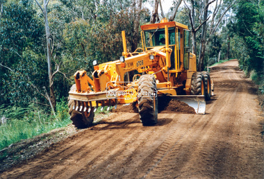
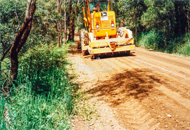
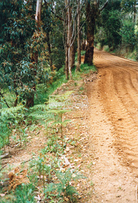
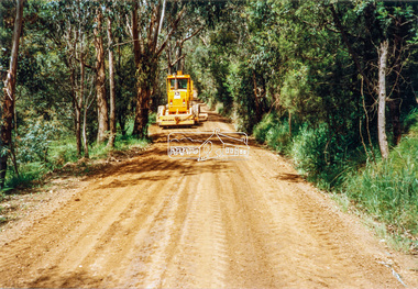
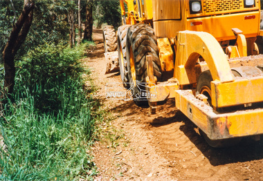
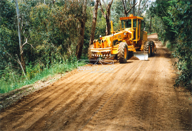
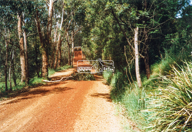
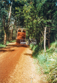
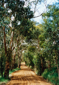
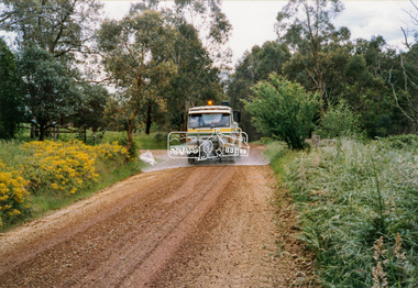
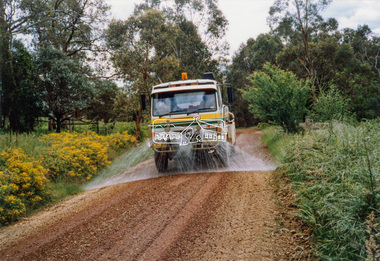
Photograph - Colour Print, Eltham Shire Council, Council oerations road grading and gravel water truck, c.1990
The cost of providing equivalent levels of services to the more rural areas of the Shire with respect to those in the more urban areas of Eltham, Montmorency and Briar Hill was relatively expensive. Road maintenance of rural unsealed gravel roads is one of those areas of higher costs particulary as a result of water erosion. The same applies for Nillumbik Shire Council today. Here we see Council operations grading a road and laying new gravel, followed by a gravel water truck to help bed the surface down. Unfortunately there is no information with these prints as to where this particular location is.graders, infrastructure, road maintenance, roads, shire of eltham, rural road, unidentified -
 Eltham District Historical Society Inc
Photograph - Black and White Print, Moor-rul Viewing Platform, March 2007
Early stages - no display panels installed. OPENING OF THE VIEWING PLATFORM AT KANGAROO GROUND Nillumbik Council has advised that the viewing platform at Kangaroo Ground 27km NE of Melbourne is to be opened to the public on Wednesday, March 26th 2008 (Melway 271 , G10). The function of the platform is to provide shelter adjacent to the War Memorial Tower whilst allowing all people to enjoy the stunning panoramic views. From the platform you. can see the Dandenongs, the city of Melbourne, the You Yangs, Mount Macedon, the Kinglake Ranges and the Mt Baw-Baw Ranges where the Yarra River starts. This landscape covers all the ancestral lands of the Wurundjeri and some of the wider Kulin nation land. The platform has been given the name Moor-rut, a name which described the fertile soils of the Kangaroo Ground area in contrast to the poorer (Silurian) country of its surrounds, which the Wurundjeri knew as 'Nillumbik' or less rich country. The full 360 degree view can be seen from the adjacent Tower of Remembrance which has 53 stairs. The viewing platform however can be accessed by wheelchair. Inside the viewing platform there are eight double sided interpretive panels giving the history and information regarding this special area. The viewing platform's interpretive panels set out the Aboriginal and European history of the area and also the geology and the local flora and fauna, so that the casual visitor comes away understanding more about this significant part of Victoria. The concept of the viewing platform is part of the refurbishment project for the Kangaroo Ground War Memorial Park which has taken place since 1997 with the active approval and financial assistance of the Nillumbik Shire Council. This project has been guided by an Advisory Committee with volunteer community representatives from the local Historical Societies, the Country Fire Authority, the Returned Services League and the Wurundjeri people. Other allied groups such as the Nillumbik Reconciliation Group have been called upon for their expertise. The initial idea for the viewing platform came from Dean Stewart when he was the caretaker while living at the park. He discussed this idea with local author Mick Woiwod and Harry Gilham of Eltham District Historical Society when they were planning the refurbishment of the War Memorial Park in 1996. When the committee was formalised by the Nillumbik Council in 1997, Nicholas Pelling, representing the CFA and RSL, joined the group. Dennis Ward, local architect, then volunteered to develop the concept plan for the refurbishment of the park and later drew up the plans for the viewing platform. The Kangaroo Ground War Memorial Park and its Tower of Remembrance is located on one of the highest locations in the Yarra Valley. The Tower of Remembrance is a unique war memorial constructed from local stone standing 14 metres high. It was built in the style of a Scottish watchtower reflecting the strong Scottish influence of the first European settlers of the district from the 1840s onward. The park was opened in 1921 and the Tower of Remembrance was dedicated in 1926 recognising the local people who served in the First World War. Those who served in the Second World War were recognised by plaques dedicated in 1951 and more recently those who served in Korea, Borneo, Malaya and Vietnam by plaques unveiled in 2001. Harry Gilham, Advisory Committee Convenor - Eltham District Historical Society Newsletter N0 179 March 2008 Black and white inkjet print on paper 14 x 21 cmmoor-rul viewing platform, garden hill, kangaroo ground, memorial park -
 Eltham District Historical Society Inc
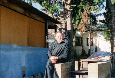
Negative - Photograph, Eltham Shire Council, Possibly a non-compliant house in Simms Road, Kinglake, c.1989
Facebook comments suggested this location may be a cabinetmaker by the name of Cook out the back of Panton Hill. Another comment recalled this man as a visitor to Montsalvat as a friend of the late poet, Geoffrey Egglestone. It is believed his name is Mizza. He is a Bohemium Poet. Also a frequent visitor to the St Andrews market. Photos taken by Eltham Shire Council officers most likely during an inspection of the property for non compliance. Other images on the roll of film are of Council Health officers undergoing food inspections at the shops, maternal health services and housing estate development inspectionsRoll of 35mm colour negative film, 6 strips Frames 3 through 9Fuji 100eltham shire council, shire of eltham, 1989, atlantic ethyl, sheds, signs, unidentified, houses, kinglake, simms road -
 Eltham District Historical Society Inc
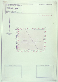
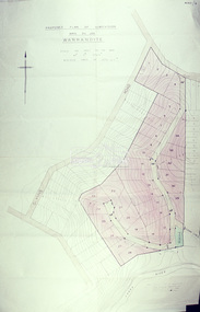
Slide - Photograph, Eltham Shire Council, Plan of Subdivision, Crown Allotment 8, Section 8A, Parish of Nillumbik,County of Evelyn, 1969
35mm colour positive transparency blue Agfacolour Service plastic mountC1, Pain, Sibbel and Carter, Research-Warrandyte Road, North Warrandyte, 4 August 1969carter, infrastructure, map, north warrandyte, pain, parish of nillumbik, plan of subdivision, planning, research-warrandyte road, sibbel, subdivison lots -
 Eltham District Historical Society Inc
Slide - Photograph, Eltham Shire Council, Plan of Subdivision of Part of Crown Allotment 4, Section 2 at Kangaroo Ground, Parish of Nillumbik, County of Evelyn, 1969
35mm colour positive transparency blue Agfacolour Service plastic mountC6, Kimse, Kangaroo Ground-St Andrews Road, 4 August 1969infrastructure, kangaroo ground, kangaroo ground-st andrews rd, kimse, map, plan of subdivision, planning, subdivison lots -
 Eltham District Historical Society Inc
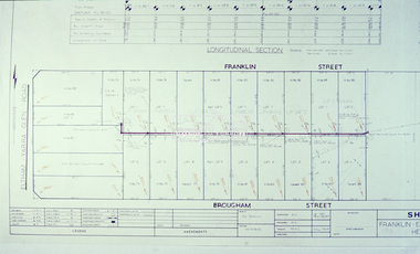
Slide - Photograph, Eltham Shire Council, EB 8 (b) Health Act Scheme, Franklin and Brougham streets, Eltham, 1969
35mm colour positive transparency blue Agfacolour Service plastic mountEB 8 (b) Health Act Scheme, 4 August 1969brougham steet, eltham, franklin street, infrastructure, map, planning, subdivison lots, health act scheme -
 Eltham District Historical Society Inc
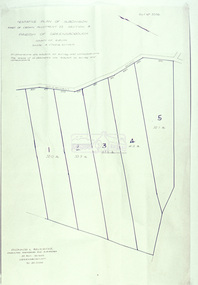
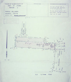
Slide - Photograph, Eltham Shire Council, Plan of Subdivision, Part of Crown Portion 3, Parish of Nillumbik, County of Bourke, 1969
35mm colour positive transparency blue Agfacolour Service plastic mountC5C, Delbridge, 4 lots, Rattray Road, 4 August 1969infrastructure, map, montmorency, planning, rattray road, subdivison lots, reichelt avenue -
 Eltham District Historical Society Inc
Slide - Photograph, Eltham Shire Council, Tentative plan of subdivision, part of Crown Allotment 22, Section B, Parish of Greensborough, County of Evelyn, 1969
35mm colour positive transparency blue Agfacolour Service plastic mountE11, N1069, Stogryn, Sub 'prop',infrastructure, map, planning, subdivison lots -
 Eltham District Historical Society Inc
Slide - Photograph, Eltham Shire Council, Proposed plan of subdivision, Mrs Du Lee, Warrandyte, 1969
35mm colour positive transparency blue Agfacolour Service plastic mountB2, Du Lee Subdivision, Research-Warrandyte Road, 4 August 1969infrastructure, map, planning, subdivison lots, du lee, glynns road, research-warrandyte road -
 Eltham District Historical Society Inc
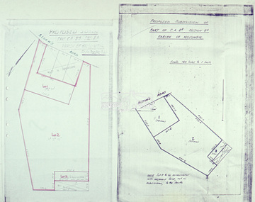
Slide - Photograph, Eltham Shire Council, Proposed subdivision of Part of Crown Allotment 8B, Section 8A, Parish of Nillumbik, 1969
35mm colour positive transparency blue Agfacolour Service plastic mountE4, N0424, Stock subdivision, North Warrandyte, 4 August 1969infrastructure, map, planning, subdivison lots -
 Eltham District Historical Society Inc
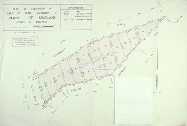
Slide - Photograph, Eltham Shire Council, Plan of subdivision of Part of Crown Allotment 41, Parish of Kinglake, County of Anglesey, 1969
35mm colour positive transparency blue Agfacolour Service plastic mountC8, N. Johnson, Kinglake-Glenburn Road, 4 August 1969infrastructure, map, planning, subdivison lots, n. johnson, kinglake-glenburn road, kinglake -
 Eltham District Historical Society Inc
Slide - Photograph, Eltham Shire Council, Plan of subdivision of Part of Crown Portion 2, Parish of Nillumbik, County of Evelyn, 1969
35mm colour positive transparency blue Agfacolour Service plastic mountC4, Warton, Panorama and Beleura, 4 August 1969infrastructure, map, planning, subdivison lots, beleura grove, old eltham road -
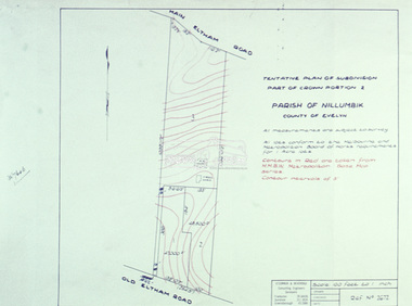 Eltham District Historical Society Inc
Slide - Photograph, Eltham Shire Council, Tentative Plan of Subdivision, Part of Crown Portion 2, Parish of Nillumbik, County of Evelyn, 1969
35mm colour positive transparency blue Agfacolour Service plastic mountB4, Fisher subdivision, Old Eltham Road and Main Road, 4 August 1969infrastructure, map, planning, subdivison lots, main road, old eltham road -
 Eltham District Historical Society Inc
Slide - Photograph, Eltham Shire Council, Tentative Plan of Subdivision, Part of Crown Allotment 20A and Part 20B, Parish of Nillumbik, County of Evelyn, 1969
35mm colour positive transparency blue Agfacolour Service plastic mountE2, N899, Young subdivision, Kangaroo Ground-Warrandyte Road, North Warrandyte, 4 August 1969infrastructure, map, planning, subdivison lots, kangaroo ground-warrandyte road, north warrandyte -
 Eltham District Historical Society Inc
Slide - Photograph, Eltham Shire Council, Proposed extension of Railway Road, Briar Hill, 1969
35mm colour positive transparency blue Agfacolour Service plastic mountA4, Railway Road intersection, 4 August 1969infrastructure, map, planning, subdivison lots, railway road, carter street bridge, para road, para road bridge, briar hill -
 Eltham District Historical Society Inc
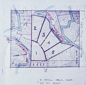
Slide - Photograph, Eltham Shire Council, Proposed subdivision of five approximately equal areas of 5 acres, Vol. 4061, Fol. 061, Overbank Road, North Warrandyte, 1969
35mm colour positive transparency blue Agfacolour Service plastic mountD4, 55341, Peck subdivision, Mount Pleasant Road, 4 August 1969infrastructure, map, planning, subdivison lots, overbank road, mount pleasant road, north warrandyte -
 Eltham District Historical Society Inc
Slide - Photograph, Eltham Shire Council, Plan of Subdivision, Part of Crown Allotments 5 & 6, Section 10, Parish of Nillumbik, County of Evelyn (Foster Road, Eltham East), 1969
35mm colour positive transparency blue Agfacolour Service plastic mountC5(a) DU (Vic) D/L Foster Road, Eltham East, 4 August 1969infrastructure, map, planning, subdivison lots, abersham court, ancona close, eltham east, floriston grove, foster road, frank street, gladwyn court