Showing 298 items
matching sketch plan
-
 Federation University Historical Collection
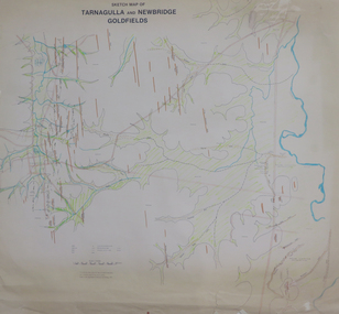
Plan, Sketch Map of Tarnagulla and Newbridge Goldfields, 1979, 1979
Pmap on paper with hand colouringtarnagulla, newbridge, map -
 Federation University Historical Collection
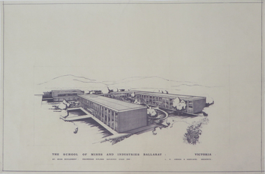
Plan, Mount Helen Campus
Sketches of the Mount Helen campus, including topography.mount helen campus, architectural drawings -
 Federation University Historical Collection
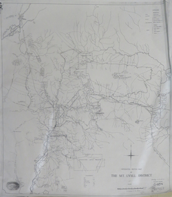
Map, Geological Sketch Map of the Mount Lyell District, 1935, 25-09-1935
Copy of a plan showing mining leases around Mount Lyell, Tasmania.mount lyell, queenstown, mining, king river -
 Bendigo Historical Society Inc.
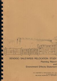
Book - BENDIGO SALEYARDS COLLECTION: BENDIGO SALEYARDS RELOCATION STUDY - PLANNING REPORT AND ENVIRONMENT
Bendigo Saleyards Relocation Study - Planning Report and Environment Effects Statement for the City of Bendigo by A E Huefner & Associates Pty Ltd in association with Meldrum Burrows & Partners. Book has a light brown cover with black plastic binder spine. Green and yellow pages separate some sections. The front cover has a sketch of a stock transport with a pig, sheep and cattle behind gates. Contents include: Introduction, Summary, Recapitulation on the Feasibility Report which includes The Need for Action, the Site and Existing Uses Adjacent to the Site, The Proposal which includes Concept, Project Description, Components, Siting of Facilities, Land Clearing, Earthworks, Darainage, Buildings and Structures, Roads and Pavements, Services, Landscaping, Soil Profile and Construction Programme. Invironmental Effects which include Visual Impact Dust, Odours, Effluent, Effluent Treatment System, Traffic, Artificial Lighting, Noise, Operational Failures and Nature Conservation Effects. Statutory Planning Considerations which includes Zoning Controls and Suggested Procedure for Initiating I.D.O. Amendment. Appendices are: A.- Copy of Tit;e, B - Soil Investigation, C - Acoustic Assessment and D - Suggested Draft Amendment to Shire of Marong I.D.O. Contains a photo of the area - View of the Site, looking South and a number of drawings. Copies of various Council Reports referring to the Saleyards Relocation Project. It has a bright yellow cover and a hard plastic type spine. Mentioned in the reports is the cost to bring the old saleyards up to standard and list of improvements. Reports are as at 16th July, 1984. Mustard coloured book with plastic spine titled Bendigo Saleyards Relocation Study Feasibility Report by Meldrum Burrows & Partners in association with A E Huefner & Associates Pty Ltd and Acil Australia Pty Ltd dated September, 1983. Items mentioned are: Introduction, Summary, Background, Role in Livestock Marketing for the Bendigo Saleyards (Acil Australia Pty. Ltd., Saleyard Relocation: Strategic Considerations, Financial Implications and Conclusion. Appendix 1: Estimation of Livestock Population in Catchment Area. Drawings in Fig 1 Existing Bendigo Saleyards and Surrounding Land Uses, Fig 2 Catchment Area for Bendigo Saleyards 1983, Fig 4.1 Estimated Sheep Populatiuon in Catchment Area 1976 - 77 to 1981 - 82, Fig 4.2 Estimated Cattle Population in Catchment area 1976 -77 to 1981 -82, Fig 3 Possible Saleyard Relocation Areas, Fig 4, Directions from which access to possible Saleyard Locations would be obtained - Estimated percentage of sheep to cattle stock, Fig 5 Possible Saleyard Locations - Northern Area, Fig 6 Possible Locations of Saleyards - Inner West, Fig 7 Possible Locations of Saleyards - Outer West. Considerations were made as to renovate the existing saleyards or to move them elsewhere. Effluent, transport and stock movement, and condition of the yards were a problem.bendigo, council, cattle markets, bendigo saleyards collection - bendigo saleyards relocation study - planning report and environment effects statement, a e huefner & associates pty ltd, meldrum burrows & partners, city of bendigo, state electricity commission, mal styles, bendigo college of advanced education, n j fieldew, pryce goodale & duncan pty ltd, p b swift, shire of marong -
 Bendigo Historical Society Inc.
Book - A LEGACY FROM THE PAST.. A LINK WITH THE FUTURE - AN OPEN SPACE STRATEGY FOR BENDIGO, 1988
32 page soft cover booklet 'A Legacy from the Past… a Link with the Future. An Open Space Strategy for Bendigo' Prepared for the Bendigo Sub-Regional Committee of the Loddon-Campaspe Regional Planning Authority, February 1988. Illustrated with maps, B&W photos and sketches. Main chapters 1. Open Space and Bendigo 2. An Open Space System - water courses and Bendigo Creek 3. The Provision of Public Open Space 4. Study Conclusions and Proposals.Evan Jones -
Bendigo Historical Society Inc.
Book - THE AUSTRALIAN BOY SCOUT DIARY 1933, 1933
The Australian Boy Scout Diary 1933. Inside front cover is an intimate picture of Chief & his family. With specially written notes and Sketches for Cubs, Scouts, Rovers and Scouters. Obtainable at all State Headquaters in Australia. Prepared and Published by the Victorian Section in conjuntion with the Federal Scout Council of Australia. Printed by Exchange Press Pty Ltd, 310 Spencer Street, Melbourne. Index: Boy Scouts. Bush Fires. Calendars 1933, 1934. 1934 Calendar. Conventional Signs and Maps. Fires. First Aid. Headquaters Address. Holidays. Knots, Bends and Hitches. List of Badges. Local Fixtures. Morse. Our Flag. Personal Memoranda. Pioneering. Plan of Camp. Rover Scouts. Scout Uniform. Scout Signs and Salutes. Sea Scouts. Sea Scouting - Notes on Boat Handling. Semaphore. South by the Stars. Swimming. Torch. Treatment of Snakebite. Troop Camps. Weights and Measures. Wolf Cubs. Wood Badge. Uses of Scout Staff. Inside rear cover is a sepia photo of the site of the 1933 Jamboree at Godollo, Hungary. Book is very detailed giving information on all aspects of Scout life, with sketches for knots, maps, etc. Inscriptions are on page 58: Troup or Pack - 1st Epsom Pack. Watch No. 4133033. Season Ticket No. Commonwealth acc 957. Savings No. 4729. Size in Hats: 7. Size of Boots: 5. Size of Collar 14 1/2. Size of Gloves 6 1/4. Iinscription on page 60: Books Read: In Search of Wales, Morton. Faraway, Priestly. Jock the Scot, Alice Grant Rosemary. Bernard Shaw, Frank Harris.Exchange Press Pty Ltd., Melbournebook, bendigo, scouts, the australian boy scout diary 1933. photo of chief & his family. notes and sketches for cubs, scouts, rovers and scouters. obtainable at all state headquarters in australia. published by the victorian section in conjunction with the federal scout council of australia. exchange press pty ltd, melbourne. index: boy scouts. bush fires. calendars 1933, 1934. 1934 calendar. conventional signs and maps. fires. first aid. headquarters address. holidays. knots, bends and hitches. list of badges. local fixtures. morse. our flag. personal memoranda. pioneering. plan of camp. rover scouts. scout uniform. scout signs and salutes. sea scouts. sea scouting - notes on boat handling. semaphore. south by the stars. swimming. torch. treatment of snakebite. troop camps. weights and measures. wolf cubs. wood badge. uses of scout staff. sepia photo of the site of the 1933 jamboree at godollo, hungary. information on all aspects of scout life, with sketches for knots, maps, etc. inscriptions page 58: troup or pack - 1st epsom pack. watch no. 4133033. season ticket no. commonwealth acc 957. savings no. 4729. size in hats: 7. size of boots: 5. size of collar 14 1/2. size of gloves 6 1/4. page 60: books read: in search of wales, morton. faraway, priestly. jock the scot, alice grant rosemary. bernard shaw, frank harris. -
Port Melbourne Historical & Preservation Society
Drawing - Sketch, Artists impression, Bayside development proposal, Port Melbourne, Barry Merat, Sep 1987
Display item used during public information sessions conducted in 1987 by the Port Melbourne City Council's (PMCC) Community Committee (Brenda BEDFORD, Frank CALLAGHAN, Ron WEST and Barry MERAT) regarding SCDC Bayside Development.Drawn by Barry MERAT for 1987 public display:a general impression of Bayside development proposal elevations as seen from bay, based on Plot Ratio of 3 to 1 and Plot Ratio of 2 to 1.Top RH corner - reverse 'WRAP'town planning - proposals shelved - bayside, public action campaigns, sandridge city development co pty ltd, scdc, brenda bedford, frank callaghan, ron west, barry merat -
Port Melbourne Historical & Preservation Society
Drawing - Sketch, Artists impression, Bayside development proposal, Barry Merat, Port Melbourne's New Town Centre, 1987
Display item used during public information sessions conducted in 1987 by the Port Melbourne City Council's (PMCC) Community Committee (Brenda BEDFORD, Frank CALLAGHAN, Ron WEST and Barry MERAT) regarding SCDC Bayside Development.Artist's impression of proposed Bayside development (highrise office blocks).town planning - proposals shelved - bayside, public action campaigns, sandridge city development co pty ltd, scdc, brenda bedford, frank callaghan, ron west, barry merat -
Port Melbourne Historical & Preservation Society
Map - Port Melbourne, Department of Lands and Survey, 20 Sep 1932
Dept. of Lands and Survey Map Sheet 5 Port Melbourne, Parish of South Melbourne.Annotated re MHT precincts on foreshore:Plan sketches re boat harbourtown planning, sandridge lagoon, melbourne harbor trust - port of melbourne authority, transport - railways -
Port Melbourne Historical & Preservation Society
Plan - Port Melbourne Yacht Club reconstruction, Taylor Howden Pty Ltd, Architects, c. 1990
Clubhouse burned 14 February 1990 and was rebuilt with volunteer labour over many years (opened 1998)Plan of Port Melbourne Yacht Club clubhouse reconstruction 1990 - pmyc, sketch of elevations of new clubhouse; faded almost to illegibilitybuilt environment - recreational facilities, societies clubs unions and other organisations, port melbourne yacht club, pmyc, taylor howden pty ltd -
Port Melbourne Historical & Preservation Society
Plan - Liardet Community Centre, Port Melbourne, Barry Merat, Architect, 1988 - 1989
... ) - copied from sketches then coloured. 1988. Plan Liardet Community ...Set of 3 preliminary drawings, plan for remodelling former Temperance Hall as new "Liardet Community Centre" (in use at this time as Senior Citizens' Centre and Children's Library) - copied from sketches then coloured. 1988.built environment - civic, port melbourne temperance hall, barry merat, liardet community centre -
Port Melbourne Historical & Preservation Society
Drawing - Sketch (copy), Proposed Military Road, St Kilda to Sandridge, 4 Apr 1865
Original proposal instigated by the Crimean War and Russian invasion scare.Copy (1865) of 1860 sketch of proposed Military Road from St. Kilda to Sandridge to link all local batteriesSigned by P. H. Scratchleytown planning - proposals shelved, war, batteries - defensive, p h scratchley, st kilda -
Port Melbourne Historical & Preservation Society
Booklet - Ministry for Planning and Environment, Urban Conservation Areas, Aug 1986
Ministry for Planning and Environment booklet of Urban Conservation Areas August 1986, detailing in words and sketches areas of inner Melbourne of special significance historically and architecturally, to be preserved. 16 pp, brown ink on cream paper.built environment, garden city, town planning, victorian ministry for planning and environment -
Port Melbourne Historical & Preservation Society
Document - Binder, Bayside Open Planning Forum, Aug 1992
Donor Pat HAWKINS participated in forum which she described as 'the most democratic thing I have ever done'Large, white, plastic binder of material relating to the Bayside Open Planning Forum, a consultation process to set a direction for planning for the 'Bayside' site, 6 - 10 August 1992. Open to the public day and night for four days, incorporating large public meetings pklus opportunity for individuals to convey their ideas to a team of town planners. Refer photos 1505.01-.08.pencil sketch inside front coverbuilt environment, town planning, public action campaigns, local government - city of port melbourne, bayside open planning forum, f patricia (pat) hawkins, beris campbell, paul merain, major projects victoria -
 Bendigo Historical Society Inc.
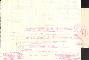
Document - ROUGH SKETCH - BEEHIVE STOCK EXCHANGE BUILDING, 1964
A rough sketch of the Beehive Stock Exchange showing occupants of the offices, ground floor and second floor plan, street names, and notes indicating why it was done. The names on this sheet indicate the tenants of some offices, Eugene Trier, Blackham & Garvin, Strode (Age office), A. Deravin, A. Williams, A. B. Harrison, J. Wills, J. Urquhart, W. Ruddick, H. Ralph, Kelly & Allsop, Feo. F Rae, Angus Kennedy, A. Kirkwood, W. Coates, Geo. F. Green, Durridges hotel bedrooms, Kerr's Billiard saloon, C. Burridge, Argus office, H. Y. Burridge, W. J. Wood, J. Stewart & Stevenson, Woolcock & Trembath, A. J. Taylor, Wood & McNair, F. Barker.organization, institution, beehive stock exchange -
 Bendigo Historical Society Inc.
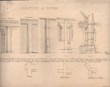
Drawing - NORMAN PENROSE COLLECTION: BROWN FOLDER, 1955
Artwork. Norman Penrose collection: large brown folder with wide black spine containing a page from Water Life with coloured sketches of the Murray Cod, the Azure Kingfisher and the Swamp-hen. A page from the Herald-Sun, Feb 13, 1955 with ladies shoes on one side and the third article of a series of Lawrence of Arabia on the other. Notes and drawings of Ionic Order (Erectheion - Athens. North Portice). And Doric Order (Temple of Theseus. Athens. 5th Cent BC). Also Corinthian Order (Choragic Monument of Lysicrates. Athens). Plan of the Parthenon. Notes on perspective. Notes and illustrations on the Development of Buttress.drawing, pencil, norman penrose collection, water life, notes on drawings, herald-sun, ionic order, corinthian order, doric order -
 Bendigo Historical Society Inc.
Document - GERTRUDE PERRY COLLECTION: HOUSE SKETCHES
Two pencil drawings. the first one of the outside of a house and the words; 'This is how your design would look darling". Semi-plan view. "I'd say you are pretty beaut". the second drawing is a plan of the inside.house, private, drawings -
Clunes Museum
Drawing - PLAN DRAWING
FACTORY COMPLEX DEMOLISHED IN APPROX. 1968PLAN DRAWN AND PAINTED WITH WATERCOLOURS OF EBERHARD & CO. CLUNES & TALBOT CORDIAL FACTORY IN FRASER STREET CLUNES. SKETCHED FROM THE MEMORY OF:-eberhard & co. cordial, clunes & talbot, plans of former buildings -
Tatura Irrigation & Wartime Camps Museum
Booklet, Internees at camp 1 Tatura, Hermann Junge, 1940's
Produced by internees at Camp 1, Tatura and intended for their and fellow internee use.Unbound, folded loose leave, booklet featuring head and shoulders black and white sketch of man on front cover. Below the name Hermann Junge is written. Typed on manual typewriter. Contains 2 maps and camp plans. 83 pagesHermann Jungehedlig docke, camp 1 tatura, hermann junge -
Tatura Irrigation & Wartime Camps Museum
Sketch, Carl Kubler, 1937
Brown wooden framed, blue/grey mat, pencil drawing of plan of Sarona featuring streets and houses, fields and plantations.Sarona Deutsche Kalone Jaffa Palaestine Januar 1937 Prod Von Carl Kublercarl kubler, camp internee sketches, sarona palestine, magdalen kubler -
Tatura Irrigation & Wartime Camps Museum
Book, Australian War Memorial, Canberra, 1941
First Edition, Australian War Memorial Canberra displays history of all who fought in the Wars. Names listed of all who died.Red and beige cover. Brown linen binding, exterior sketch of forecourt and dome n front and back. Includes floor planww1 and ww2, military, australian deaths in ww1 -
 Anglesea and District Historical Society
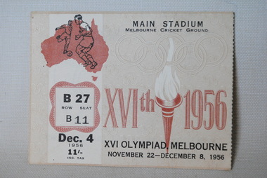
Ticket, XVIth Olympiad Melbourne Ticket, 1956
Entry ticket to the Olympic Games in Melbourne in 1956. Row B, seat 27 for the 4th of December 1956. Tickets were printed in 15 - two colour combinations based on 4 basic colour backgrounds and seven overprints. Thus there was a colour for each day of the Games. The back of the ticket showed a plan of the particular stadium indicating the position of the seat.Front: Pictures of soccer players and Olympic Torch. MAIN STADIUM / MELBOURNE CRICKET GROUND / XVI OLYMPIAD MELBOURNE / NOVEMBER 22 - DECEMBER 8, 1956 / B27 / ROW SEAT B11 / DEC 4 1956 / DEC 4 - INC. TAX. Back: Sketch of stadium / 3rd elevation / Brunton Ave. / Score board / Finish / Main Stadium / Melbourne Cricket Ground.olympic games, melbourne 1956, ticket -
Tatura Irrigation & Wartime Camps Museum
Photograph, Dhurringile Escape, 2001
Dhurringile Escape through Tunnel. Detmers; Bertram; Grotz; Jas; Kernstock; Folter; Jung; Plattfaut; Jansen; Menge; Kissel; Raasch; Eberle; Somann; Mader; Blomberg; Koch; Sommer; Rodszies; Schmidt. 2 Articles. Further references in folders: 1829- sketch of camp 13 tunnel.|800- Plan of Dhurringile with room allocation of POW's 858- Army Garrison. 1762- Intelligence Reports. Newspaper articles in top drawer of plan cabinet.detmers, bertram, grotz, jas, kernstock, folter, plattfaut, jansen, menge, kissel, raasch, eberle, somann, mader, blomberg, koch, sommer, rodszies, schmidt, room allocation -
Tatura Irrigation & Wartime Camps Museum
Folder, Persian Group
List of names, hut allocation and leaders of Persian Group relocated from Loveday to Camp 1. Copy of "Decision in Persia" by Philipp W. Fabey. Copies of sketches by Eugen Graf Mensdorff. Letter from Graf von Mensdorff, camp leader to German Red Cross. Plan of Loveday Camp 14. Records of Arnold Abineri, Copy of passport, records & recollections of Stephan Asboth. Theatre Programs. Copies of mail covers. Correspondence re repatriation questionnaire. Magazine for Hockey Group, 1943, including distribution list. Jeppe von Bergo - cast in playBlue two ring folder with printed material in plastic sleeves.documents, reports -
Tatura Irrigation & Wartime Camps Museum
Photograph, Camp 1 sketch plans, 2001
... Tatura the-murray photograph people Camp 1 sketch plans ...photograph, people -
Clunes Museum
Plan - ARCHITECTS PLANS, DARYL JACKSON REPORT PTY. LTD
SKETCH DESIGN REPORT - WESLEY AT CLUNESARCHITECTS PLAN WESLEY AT CLUNES. DARYL JACKSONlocal history, document, plans, education, schools, wesley -
Stawell Historical Society Inc
Archive, Plans from the Dept. Works Ararat
Archive 4262 Plans For Pleasent Creek 4262 - Existing Plans for Pleasent Creek 4262A - 2A Bellfield Unit 4262B - 2B Fyans Unit 4262C - 2C Nurses Unit 4262D - Biala Unit 4262E - Hostel Unit 4262F - Residence 3 & 4 (X2) 4262G - Residence 5 & 6 4262H - Nara Unit 4262I - Syme Unit 4262J - Lonsdale Unit 4262K - School Buildings 4262L - Recreation Building 4262M - Administration Building 4262N - Alexandra Building 42620 - L.T.O. building 4262P - Engineers Workshop & Laundry 4262Q - Sewing Room & Stores 4262R - Carpenters, Painters & Gardener's Workshops 4262S - 3 Existing Plans for Pleasent Creek Centre Stawell & Emergency Water Legend 4262T - 7 Existing Plans for Plesent Creek Stawell Centre Stawell Inc: Grid Squares 4262-1 73.5 X 56 CM Sheet No.1 New Dining Room Special School Amended Setout of Windows 4262-1A - 73.5 X 56 CM Sheet No. 2 Special School Stawell Joiners details 4262-1B - 73.5 X 56 CM Sheet No. 3 Pleasant Creek School: New Dining Room 4262-1C -73.5 X 56 CM Sheet No. 4 Pleasant Creek School Joinery details 4262-1D - 73.5 X 56 CM Sheet No. 5 Pleasant Creek School Joinery Details 4262-1E - 48 X 39 CM Section AA Pleasant Creek School Dining Room Stainless Steel Sinks & Drains 4262 -1F 50 X 69X5 CM School for Subnormal Children - Stawell Mental Hospital Elvation and Accordion 4262-1G 56 X 40 CM Sheet 6 Stawell Pleasant Creek School - Joinery Detail 4262-1H 75 X 54 CM Stawell Pleasant Creek School - Detail of Serving Window 4262 -1I 75 X 54 CM Stawell Hospital for the Insane - Cills to Windows, Store and soon to be Male Division 4262 -1J 50.5 X 24 CM Stawell Pleasant Creek School - deatils of Serving Window 4262 -2 39 X 34 CM Concongella School 1136 Sundry Works etc. 4262-2A 20 X 35 CM State School 1702 Joel Joel - Remodeling & Repairs Painting etc. 4262-2B 36 X 44.5 CM Mokepilly School Remodelling 4262-2C 21 X 34 CM 2951 Marnoo East - Sketch of Proposed Cloak Room 4262-2D 21 X 34 CM SS 2951 Marnoo East Elevation Showing New Cloak Room 4262-2E 40 X 39 CM Additions & Alterations to Concongella School 1136 4262-2F 21.3 X 33.5 CM School 2951 Marnoo East Elvation and Ground Plan 4262-2G 38 X 33.5 CM School 1554 Marnoo & Residence 4262-2H 21.5 33.5 CM Marnoo SS No 1554 Repairs and Painting 4262-2I 205 X 32 CM Marnoo School 1554 Alternative Drawingsfor building In Brick 4262-2J 50 X 43.5 CM New Concrete School 1554 Marnoo 4262-2K 62 X 56 CM Removal & Alterations to Marnoo's School No. 1554 4262-2L 49.5 X 33.5 CM Great Western School 860 - Teacher's Residence 4262-2M 20.5 X 33.5 CM Great western School 860 - Elevation & Ground Plan 4262-2N 20.5 X 33.5 CM Great Western School 860 - Shelter Sheds & Tank Stand 4262-2O 25.5 X 30 CM Great Western School 860 - Floor Plan 4262-2P 20 X 34 CM Residence to Great Western Schhool - Plastering & Painting etc,. 4262-2Q 59 X 50.5 CM Great Western School860 - Additions 4262-2R 21 X 33 CM Plan school 263 Glenorchy 4262-2S 21 X 33 CM Plan School 263 Glenorchy 4262-2T 35 X 38 CM Glenorchy School 263 Remodelling etc,. to Teacher's Residence 4262-2U 33.5 X 22 CM Repairs & Repainting School & Residence Glenorchy SS 263 4262-2V 53 X 34 CM Proposed Sleepout for Teachers Residence Glenorchy School 4262-2W 53.5 38 CM Glenorchy School No. 263 and Residence Raising School buildings etc,. 4262-2X 29 x 56 CM Glenorchy School 263 New Cloak Room etc. 4262-3 22 X 31 CM Drawing of Part of Builing 4262-3A 35 X 46 CM Stawell Roof Plan & Side Elevation 4262-3B 48 X 65 CM State School Drawing No 1 4262-3C 32 X 27 CM Renewal of Existing water Supply 4262-3E 61 X 40 CM Stawell Infant State School 503 - External Repairs & Renovations 4262-3F 48.5 X 53 CM Education Department Stawell State School Drawig No 2 Contract 181 4262-3G 73 X 55 CM Alterations & Additions S.S. 502 Stawell Drawing No.1 4262-3H 73 X 55 CM Alterations & Additions S.S. 502 Stawell Drawing No.2 4242-3I 73 X 55 CM Alterations & Additions S.S. 502 Stawell Drawing No.3 4262-3J 56 X 34 CM State School 502 Plan Clarifying & Chlorinating Chamber 4262-3K 33 X 21 CM Part Ground Plan StawellSchool 502 - Accordion Doors etc. 4262-3L 60 X 54 CM Accordion Door details for School at Stawell 502 4262-3M 69 X 52 CM Stawell State School No 502 External repairs - Renovations 4262-3N 72 X 55 CM Altereed & Additions State School 502 Drawing No 1 4262-30 35 X 21 CM Stawell School 502 New Wood Shed etc 4262-3P 68 X 34 CM Main School - New Gutters shown thus. State School 502 Stawell Renewals Eaves Guttering 4262-3Q 58 X 34 CM State School No 502. Stawell Block Plan 4262-3R 73 X 55 CM State School 502 Drawing No.2 4262-4 99 X 79 CM State of Victoria Public Works Department - Layout of heating System Administration Block and Toddlers Playroom. Pleasant Creek special School (2 Copies) 42624A 86 X 89.5 CM Existing Layout of Peasnt Creek Centre Fire Service Water Mains 4262-4B 87X 59.5 CM Department of Human Services Victoria Emergancy Schematic Palns Pleasant Creek Centre ( Plans also in 4262 & 4262-1?) Cover Sheet. Former Pleasant Creek Hospital site. Sometimes referred to as Pleasant Creek Special School and sometimes Pleasant Creet Training Centre.Plans of Schools and other Buildings -
Stawell Historical Society Inc
Archive - Books & Papers, The Australian Sketcher Article Stawell and the Pleasant Creek reefs July 12 1873, July 12 1873
Article printed after legislation arising out of 'Jumped Claims' back in history of Pleasant Creek - alluvial and quartz mining Currant mining operationsPhotocopy of article with lithographs and plan of Stawell -
Whitehorse Historical Society Inc.
Document, Display Centre, 1987
... Plan, 4 elevations and sketch of the display centre... elevations and sketch of the display centre Plan, 4 elevations ...Plan, 4 elevations and sketch of the display centrePlan, 4 elevations and sketch of the display centre|Nunawading Historical SocietyPlan, 4 elevations and sketch of the display centrenunawading historical society, schwerkolt cottage & museum complex -
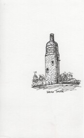 Rutherglen Historical Society
Ink sketch, Pat Robinson, Water Tower, c1990
Ink sketches of Rutherglen landmarks and old buildings produced by local artist Pat Robinson for planned Historic Walk brochure (not used)One of a series of black and white ink sketches, on paper, of Rutherglen landmarks. This one showing the water tower with the structure that was added to the top to make it look like a wine bottle. pat robinson, buildings, artist, water tower, wine bottle