Showing 247 items matching "stawell gold mining"
-
 Stawell Historical Society Inc
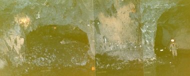
Photograph, Stawell Gold Mine, Stawell Gold Mine Drives Underground 1988
... grampians Panorama Gold Mining Workers standing in Stawell Gold Mine ...Workers standing in Stawell Gold Mine Underground Drives. One Drive showing rock backfillpanorama, gold, mining -
 Stawell Historical Society Inc
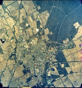
Photograph, Stawell Aerial Photographs
... 3 Aerial photographs of Stawell possibly mining Surveys... mining Surveys for Stawell Gold Mines Stawell Aerial Photographs ...3 Aerial photographs of Stawell possibly mining Surveys for Stawell Gold MinesCoordinates -
 Stawell Historical Society Inc
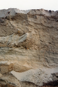
Photograph, Panorama Moonies No3 Dam 1988
... grampians gold mining Moonies No3 Dam Old Tailings Old Tailings ...Old Tailings showing Soil Layers in wall of Cutting. 28/11/1988Moonies No3 Dam Old Tailings gold, mining -
Stawell Historical Society Inc
Photograph, Panorama of Stawell from Big Hill
... grampians gold mining panorama Two sets of Four Photographs Panorama ...Two sets of Four Photographs gold, mining, panorama -
 Stawell Historical Society Inc
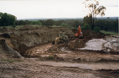
Photograph, Magdala East Tailings 1988
... grampians gold mining Excavator and Grader working on Magdala East ...Excavator and Grader working on Magdala East Tailings 1988gold, mining -
 Stawell Historical Society Inc
Photograph, Magdala East Tailings 1988
... grampians gold mining Soil layers Magdala East Tailings 1988 Magdala ...Soil layers Magdala East Tailings 1988gold, mining -
 Stawell Historical Society Inc
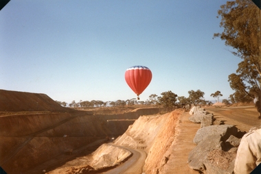
Photograph, Balloon over Wonga Opencut
... grampians gold mining tourism Wonga Open Cut 1988 Balloon over Wonga ...Wonga Open Cut 1988gold, mining, tourism -
Stawell Historical Society Inc
Map, Township of Stawell Photo Map, 1947
... grampians mining gold map Photograph of Stawell from Air Circa 1947 ...Photograph of Stawell from Air Circa 1947. Shows mining sites and townshipmining, gold, map -
Stawell Historical Society Inc
Map, Department of Mines Victoria, The Reefs. The Principle Reefs at Quartz Reefs, 1868
... grampians mining gold map Tracing Shewing the position ...c1868 Map showing the position of principal Reefs at Quartz ReefsTracing Shewing the position of the principle reefs at Quartz Reefs. Scale 8 Chains to an inch mining, gold, map -
Stawell Historical Society Inc
Map, Department of Mines Victoria, Alluvial Map Stawell Region, 1870's
... grampians mining gold map Department Mines Victoria 1952/G/2 c1870 ...c1870 Coloured map showing Black Range North to Stawell and Illawarra. Shows geological layout.Department Mines Victoria 1952/G/2 mining, gold, map -
Stawell Historical Society Inc
Map, Stawell Gold Mine, Provisional Plan Wonga Area, c1980
... grampians mining gold map Wonga Area 1:1000 Base Geological Sheet ...c1980 Preliminary Provisional Reconnaissance Plan Showing Workings Above and Below water LevelWonga Area 1:1000 Base Geological Sheet mining, gold, map -
Stawell Historical Society Inc
Map, Western Mining Stawell, Germania Summary Plan & Geology Western Mining Corporation, September 1988
... grampians mining gold map Germania Summary Plan & Geology 2003-566 1 ...Germania Summary Plan & Geopogy Western Mining Corporation Stawell VicGermania Summary Plan & Geology 2003-566 1:1000 mining, gold, map -
Stawell Historical Society Inc
Map, Geological Survey Office, Sloanes & Scotchmans united Mine, December 1916
... grampians mining gold map Geological Survey Office Ballarat December ...Sloane & Scotchman's Geological Survey Map 1916 Showing Underground DrivesGeological Survey Office Ballarat December 1916 mining, gold, map -
Stawell Historical Society Inc
Map, Charles C Reilly, Oriental & North Cross Reef Mine showing underground drives, 3/5/1900
... grampians mining gold map Charles C Reilley 3.5.00 Underground ...Underground Survey of Mines Stawell c1900Charles C Reilley 3.5.00 mining, gold, map -
Stawell Historical Society Inc
Map, Sloanes & Scotchmans Company showing underground drives, c1900
... grampians mining gold map Sloanes & Scotchmans Coy Underground ...Underground Workings Mapc1900Sloanes & Scotchmans Coy mining, gold, map -
Stawell Historical Society Inc
Map, Gold Mines of Australia, Gold Mines of Australia underground workings. Newington Rd Darlington Rd Area 1950, 1950
... grampians mining gold map Gold Mines of Australia Stawell Investment ...Plans Showing Surveys & Drilling Stawell InvestmentGold Mines of Australia Stawell Investment 2003 mining, gold, map -
Stawell Historical Society Inc
Map, Gold Mines of Australia, Geological Plan Wonga Mine Area Stawell Investigation, 1950
... grampians mining gold map Gold Mines of Australia Ltd Plans Showing ...Plans Showing Stawell Investment 1950Gold Mines of Australia Ltd mining, gold, map -
Stawell Historical Society Inc
Map, Gold Mines of Australia, Stawell Investment Geological Plan. Mine Area showing Mineshafts
... grampians mining gold map Gold Mines of Australia Ltd The Reefs Mine ...The Reefs Mine shaft locationsGold Mines of Australia Ltd mining, gold, map -
Stawell Historical Society Inc
Map, G C Birch Mining Surveyor, Magdala Cum Moonlight Co. Plan of Stawell Goldfield, c1900
Shows Sloanes & Scotchmans Coy AreaShowing underground drives. c1900G C Birch Mining Surveyor mining, gold, map -
Stawell Historical Society Inc
Map, Western Mining Corp / Stawell Joint Venture, Stawell & District with Mine Working Areas shown in red, 1987
... grampians mining gold map Legend of Mine workings numbered. 1980's ...Covers from Magdala East site to Germania in North and Hand in Hand at West Legend of Mine workings numbered. 1980's mining, gold, map -
Stawell Historical Society Inc
Map, Stawell Gold Mine, SGM Mineralized System Longitudinal Projection showing Diamond Drilling Holes 2007, June 2007
... grampians mining gold map Legend of Mine workings numbered. 1980's ...Section of Big Hill showing Diamond Drill holes through Magdala, Magdala North and Golden Gift Ore bodies to 2000m levelLegend of Mine workings numbered. 1980's mining, gold, map -
Stawell Historical Society Inc
Map, Crocodile Gold Corp, Photographic Aerial View of Big Hill showing underground workings and surface workings and proposed Big Hill Open Pit proposal, December 2014
... grampians mining gold map Aerial Views Stawell Crocodile Gold Corp ...Crocodile Gold Corp SGM photo Map showing Magdala Decline& Wonga Decline December 2014 Produced for Public Consultation over Big Hill Open Pit Proposal. Aerial Views Stawellmining, gold, map -
Stawell Historical Society Inc
Map, Stawell Gold Mine, Stawell Gold Mine Photo Map of Stawell Township showing Underground Declines in mining lease, 2007
... grampians mining gold map Aerial Views Stawell SGM photo Map 2007 ...SGM photo Map 2007 Produced for Public Consultation over Big Hill Open Pit Proposal. Aerial Views Stawellmining, gold, map -
Stawell Historical Society Inc
Map, Western Mining Corp / Stawell Joint Venture, Cross Section of Shafts. Long Section Newington - Three Jacks Looking West, August 1991
... grampians mining gold map Western Mining Corporation Limited Stawell ...WMC/SJV Cross Section Western Mining Corporation Limited Stawell Joint Venturemining, gold, map -
Stawell Historical Society Inc
Map, Western Mining Corp / Stawell Joint Venture, Aerial Photo of Wonga Open Cut and Tailings Dam No 2 proposed extension, January 1991
... grampians mining gold map Western Mining Corporation Limited Stawell ...Shows proposed extension No2 Tailings Dam off Lavett Road and proposed Revegetation Corridors Western Mining Corporation Limited Stawell Joint Venturemining, gold, map -
Stawell Historical Society Inc
Map, Stawell Joint Venture, Map of Stawell showing Mining Lease Boundary and Freehold Land, September 1988
... grampians mining gold map Stawell Joint Venture Map of Stawell ...Stawell Joint Venturemining, gold, map -
Stawell Historical Society Inc
Map, Gold Mines of Australia, Plan of Stawell Goldfield. Mining Leases, 1952
... Locations 1952 Plan of Stawell Goldfield. Mining Leases. Map Gold ...And Shaft Locations 1952 G G Birch Mining Surveyormining, gold, map -
Stawell Historical Society Inc
Map, Stawell Joint Venture, Mine Site Detail Plan, September 1989
... grampians mining gold map 1989 Mine Site Detail Plan Map Stawell ...1989mining, gold, map -
 Stawell Historical Society Inc
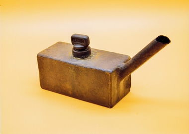
Photograph, Miners Lamp J Ladd
Used for a lamp in the gold minesRusted Rectangular Metal box with spout and screw top filling plugJ Laddmining, gold -
 Stawell Historical Society Inc
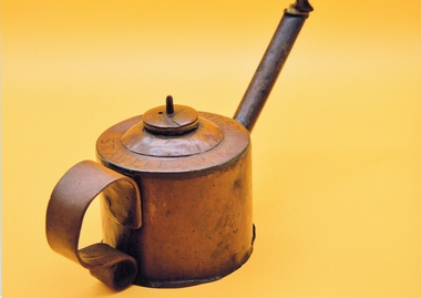
Photograph, Miners Lamp
... grampians mining gold Miners Lamps Engraved R Davidson Stawell ...Round Miners Lamp with screw filler long spout and wick.Miners Lamps Engraved R Davidson Stawellmining, gold