Showing 247 items
matching the bluff
-
 Glenelg Shire Council Cultural Collection
Souvenir - View Ware Ashtray - Portland, n.d
Horseshoe shaped View Ware clear glass ashtray, with image from Whaler's Bluff, Portland Vic, looking from north of the lighthouse across to the port. Green painted bottom.souvenir, view ware, portland, portland harbour -
 Lakes Entrance Historical Society
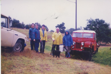
Photograph - Landcare, Lakes Post Newspaper, 1995
Colour photograph Tambo Bluff Landcare Group members Luke Bale, Cheryl Maynard, Tim Zander, David Hardiman, and Joan Kinnon at working bee. Lakes Entrance Victorialandcare, volunteering -
Glenelg Shire Council Cultural Collection
Pamphlet - Brochure - Roso Train, 1923, Oct-23
Souvenir brochure of the visit of the Roso train stop at Portland on October 9 1923. Eight pages, monochrome blue image of Bentinck St on front cover, and Whaler's Bluff lighthouse on back. -
Glenelg Shire Council Cultural Collection
Negative - Negative - Whalers Bluff, Portland Victoria, ZILLAH MASCHMEDT, PHOTOGRAPHER, c. 1934
Negative for a black and white photograph. View from Whaler's Bluff, looking out over Portland Harbour. Nun's Beach, Ocean Pier, Railway Pier, Fishermen's Breakwater, Battery Point. -
Glenelg Shire Council Cultural Collection
Photograph - Photograph - Clifton Beach, Portland, n.d
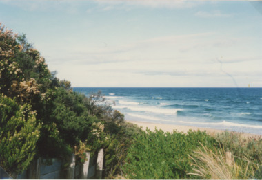
Black and white photo. view from cliff top above Clifton Beach, looking towards lighthouse and Whaler's Bluff. harbour, coastline, Lawrence Rocks in background. Cow grazing in foregroundBack: 'Clifton Beach Portland' - handwritten, black ink. '1' - pencilportland beach, clifton beach, whalers bluff, portland harbour -
Glenelg Shire Council Cultural Collection
Photograph - Photograph - Main Breakwater construction, Portland, n.d
Port of Portland Authority Archivesport of portland archives, harbour construction, development, wharf -
 Lakes Entrance Historical Society
Photograph - Natural Entrance, 1880c
Taking the Bar, 1876 woodcut of original entrance, with paddle steamer 'Lady of the Lake' and pilot boat grinding through rough conditions, can see Roadknight's Jetty, they lived at Merrangbaur, is aboriginal for home of lyrebirds.Colour photograph of a painting of a ship being towed over the natural entrance to the Gippsland Lakes. Red Bluff in background, Roadknight Jetty glimpsed through the natural vegetation. Lakes Entrance VictoriaTaking the Bar from Roadknights Jettyships and shipping, jetties, waterways -
 Lakes Entrance Historical Society
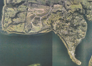
Photograph - Metung, Gippsland Ports, 2006 c
Colour aerial photograph showing Shaving Point at Metung including Chinamans Creek at the right housing subdivisions of Kingscove Estate Tambo Bluff Estate and Lake King on Gippsland Lakes Victoriaaerial photograph, topography, waterways, metung -
 Halls Gap & Grampians Historical Society
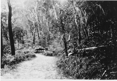
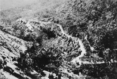
Photograph - Sepia, C 1920s
C 1920s. Photo shows the jinker track which was replaced by the Mt Victory Road (then called Bluff Rd) during the 1920s.Photo shows a track through bush. An old car sits off to side of road just after a bend.access routes, roads, access routes, jinker track -
 Kiewa Valley Historical Society
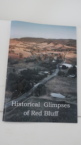
Book - Red Bluff, Historical Glimpses of Red Bluff by Karral Miller
A4 book with glossy colored cover showing the area of Red Bluff and the title written in white across the bottom. The back cover is white. There are 50 pages including some with black and white photos.On the title/cover page Karral's signature and date 'February 2021'red bluff, karral miller, kiewa valley -
 Lakes Entrance Historical Society
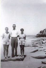
Photograph - Scarce/Fisher at Red Bluff, H D Bulmer, 1956 c
Black and white photograph of west side of Red Bluff showing rocks strewn along beach, three people on beach Heather Scarce, Keith Scarce and Kaye Fisher Lake Tyers Beachenvironment -
 Halls Gap & Grampians Historical Society
Photograph - Sepia, C 1930s
The Mt Victory Rd was originally called the Bluff Road After improvements and extension it was renamed at its opening by Lady Somers in Mar 1930Photo shows the newly formed Mt Victory Rd. with the bridle track above it Photo taken from the top of the Elephant's hideaccess routes, roads -
 Halls Gap & Grampians Historical Society
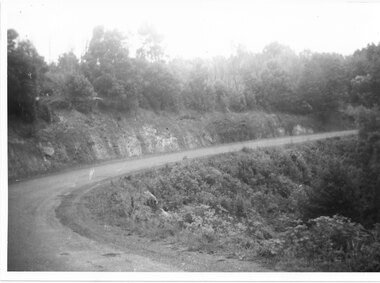
Photograph - B/W, C 1930s-1940s
Mt Victory Rd once known as the Bluff road was opened by Lady Somers Mar 1930. This section of the raod is beyond Stoney Creek Gorgephoto shows sweeping bend on Mt Victory Rdaccess routes, mt victory rd, roads -
Glenelg Shire Council Cultural Collection
Souvenir - Souvenir Tea Towel - Historic Lighthouses, n.d
Souvenir tea towel, 100% cotton. Historic Lighthouses. The Great Ocean Road and Shipwreck Coast. Coloured imaes of lighthouse including Portland (Whalers Bluff). Overprinted with 'Greetings from Portland Victoria' - in black.souvenir, lighthouse, great ocean road, south west coastline -
Glenelg Shire Council Cultural Collection
Negative - Negative - Henty Beach, Portland, c. 1934
Negative for black and white photograph. View of Henty Beach Portland, taken from lawns, looking north. Beach shelters in the foreground, Henty Memorial, Railway Pier, Ocean Pier, Baths, Whaler's Bluffzillah maschmedt, negative, henty beach, portland -
Glenelg Shire Council Cultural Collection
Photograph - Photograph - Dutton Way, n.d
Black and white photo taken from glass plate negative, attached to heavy card. Dutton Way looking towards Whalers Bluff, road with fence above beach and a horse tied up to post.Front: 'Dutton Way 1900' - black texta -
 Lakes Entrance Historical Society
Photograph - Red Bluff, 1992
Colour photograph taken from the base at the Red Bluff looking to the south east shows low shrubbery on higher elevation above sandy beach, surf breaking with ocean beyond Lake Tyers Victoriaocean, waterways, sand dunes -
Glenelg Shire Council Cultural Collection
Negative - Negative - View over Harbour, Portland Victoria, Zilah Maschmedt, 1961
Negative for a black and white photograph. Image shows view over Portland Harbour, Whalers Bluff and lighthouse, right foreground, Lee Breakwater, Ocean Pier, LS Anderson Wharf, Battery Point and Lawrence Rocks. -
 St Kilda Historical Society
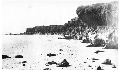
Photograph, Red Bluff, c. 1906
Copy courtesy LaTrobe Librarycopy of black and white photographRed Bluff taken in 1906 by L.W. Brownlie. Copy courtest of Latrobe Library, Melbourne. St Kilda Historical Collection. 50 Carlisle st, St Kilda. -
 Bayside Gallery - Bayside City Council Art & Heritage Collection
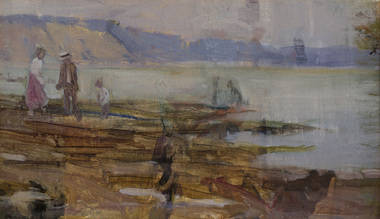
Painting - oil on canvas, Jessie Constance Alicia Traill, Beach scene, early 20th century
This work depicts the coast at Black Rock. Figures in early 20th century outfits are dotted on the oxide rocky outcrops in the foreground and beyond the water the hazy Red Bluff cliff dominates the coast.Impressionismoil on canvasbeach, coast, figures, jessie traill, red bluff, bayside, black rock, bathers, port phillip bay, bay, water -
Glenelg Shire Council Cultural Collection
Postcard - Postcard - Portland Lighthouse, c. 1950
Postcard showing lighthouse & Harbour, Portland, Victoria, from the "Rose" series ----colourview No 503, showing adult & three children walking on an unsealed road north of Whaler's Bluff. Clothing suggests c. 1950's-60'spostcard, view of portland, holiday, whalers bluff, lighthouse -
Glenelg Shire Council Cultural Collection
Photograph - Contact Print - Whaler's Bluff, Portland, 1970s
Black and white stereoscopic contact print from glass plate negative. Image of view looking north to Whalers Bluff, showing Catholic Church spire, lighthouse, railway cutting, goods sheds. Picket fence in foreground of image.portland photography, whalers bluff, lighthouse -
 Glenelg Shire Council Cultural Collection
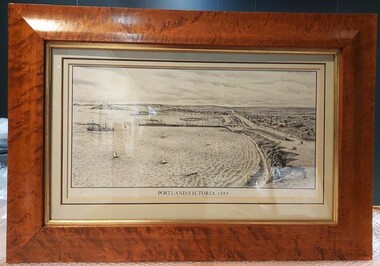
Print, Portland 1888, 1888
Framed lithograph, black and white, view of Portland from Whalers' Bluff. Double matte board, glass covered. Frame laminated, walnut veneer, gold inner strip. Back covered in brown paper, string hanging stripFront: 'PORTLAND 1888' - Black print, mat board Back: White label 'Spencer Scott, Sandilands Gallery'portland, whalers bluff, 1800s -
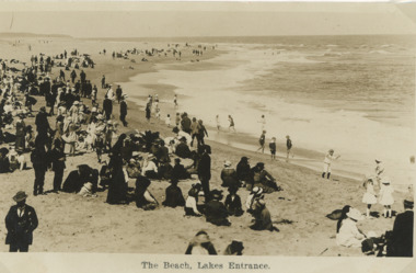 Lakes Entrance Historical Society
Postcard - People on beach Lakes Entrance Victoria c1910, H D Bulmer, 1910 c
Sepia toned postcard showing a crowd of excursionists on beach near Eastern Pier all dressed in Sunday Best clothes a few small boys paddling on waters edge. Glimpse of Red Bluff in background Lakes Entrance VictoriaThe Beach Lakes Entrancebeaches, social history, people, recreation -
 Orbost & District Historical Society
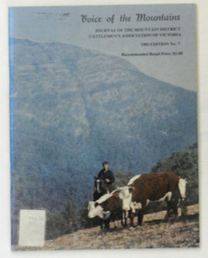
journal, Mansfield Courier, Voice of the Mountains, 1982
"The Association was officially launched in November 1967 with the aim of preserving and maintaining good relations and understanding within the cattle industry and between that industry and all bodies and organisations with which the industry is associated in the spheres of Government, and land use and marketing." (ref Mountain Cattlemen's Association web-site) Since 1972, the Mountain Cattlemen’s Association of Victoria, have produced a journal, “The Voice of the Mountains”. This journal commemorates the activities and history of the previous twelve months and bygone years of cattlemen and their families. This item was used in the library of Orbost Secondary College. The journals form a part of Victoria’s history and are a useful research tool.A 48 pp book covered in clear contact.On the front cover is a photograph, "Mustering Herefords on the Bluff". In black print it is titled :"Voice of the Mountains, Journal of the Mountain District Cattlemen's Association of Victoria, October 1982 Edition No 7" and is priced at $3.00.journal-voice-of-the-mountains cattle-industry cattlemen-history -
Glenelg Shire Council Cultural Collection
Photograph - Photograph - Photographed print of a re-photographed photograph Nuns Beach, c. 1970
Photographic print of a rephotographed photograph. Image shows Nuns Beach. Photo taken on sand looking north to Whalers Bluff. 3 small wooden buildings built against cliffs. Hull of large boat on blocks on sand against cliff.Front: 'Nuns Beach' - green inck -
 Lakes Entrance Historical Society
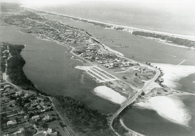
Photograph - Lakes Entrance, 1975c
Black and white photograph of an aerial view of township and Kalimna Heights, showing the North Arm bridge and boat ramp, sand buildup in the lake system, boat harbour, sand hummocks and beach as far as Red Bluff. Lakes Entrance Victoriaaerial photograph, topography, township -
 Kiewa Valley Historical Society
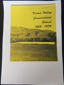
Booklet - Kiewa Valley Consolidated School x5, Kiewa Valley Consolidated School 1953 - 1974
Kiewa Valley Consolidated School was established in 1953 combining Dederang North, Kergunyah, Gundowring, Kiewa, Gundowring Upper, Red Bluff, Charleroi and Gundowing North schools on a 10 acre site with 11 rooms at Kiewa.The above schools are in the Kiewa Valley. The date and number of combined schools give insight into the change in population and families in the Kiewa Valley before and after 1953.Five A4 photocopied pages of a yellow and black booklet including the first 9 pages.kiewa valley consolidated school; dederang; kiewa valley; education -
Glenelg Shire Council Cultural Collection
Souvenir - China Plate, Tuscan China, England, n.d
Round, white china plate with bow shaped handles, with gold highlights; gold rim, colour decal, looking towards lighthouse.Front: 'LOOKING TOWARDS LIGHTHOUSE BLUFF, PORTLAND, VICTORIA' Back: Makers green stamp 'TUSCAN CHINA WHITE STICKER MADE IN ENGLAND' '$35 AL020-15' - black pen -
Tatura Irrigation & Wartime Camps Museum
Photographs, Kormoran Crew at Carnarvon, 1941
Photographs taken at the time when the Kormoran survivors from the lifeboat which landed at Red Bluff, W.A. were transported to gaol at Carnarvon, then transported to Harvey POW. Camp. Original photos enlarged and donated to Tatura Museum.Black and white photoshsk "kormoran", hmas "sydney", red bluff, wa, carnarvon, photography, photograph, slides, film