Showing 9430 items
matching the boulevard
-
 Melbourne Tram Museum
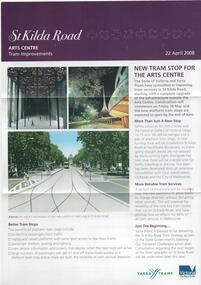
Pamphlet, Yarra Trams, "St Kilda Road - Arts Centre Tram Improvements", April 2008
Pamphlet - 3 fold A4 pamphlet, full colour, titled "St Kilda Road - Arts Centre Tram Improvements" detailing the construction schedule and photos of the Superstops and additional tracks outside the Arts Centre in St Kilda Road. Shows a track layout including a revised junction for South Melbourne Trams and Southbank Boulevard. Has Yarra Trams and State Government logos. Dated 24/4/2008.trams, tramways, st kilda rd, arts centre, road works, superstops -
 University of Melbourne, Burnley Campus Archives
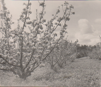
Album - Black and white print, A.W. Jessep, Lantern Slide Photograph Album, 1930-1931
Black and white photographs pasted in light cardboard loose-leaf photograph album, "1930" written on inside front cover. Probably prints of A.W. Jessep's Lantern Slides. (1) Orchard. (2) Lawn and glimpse of Principal's Residence. (3) Shrub. (4) Shrub. (5) As (2). (6) Garden view. (7) Garden view. (8) Orchard. (9) Lagoon or Boulevard Paddock see B11.0351.a.w. jessep, orchards, lawns, principal's residence, shrubs, garden views, orchards, lagoon paddock, boulevard paddock, lantern slides -
 Kew Historical Society Inc
Plan - Subdivision Plan, Oswinia Estate, East Kew, c.1925
Prue Sanderson, in her groundbreaking ‘City of Kew Urban Conservation Study : Volume 2 - Development History’ (1988), summarised the periods of urban development and subdivisions of land in Kew. The periods that she identified included 1845-1880, 1880-1893, 1893-1921, 1921-1933, 1933-1943, and Post-War Development. These periods were selected as they represented periods of rapid growth or decline in urban development. An obvious starting point for Sanderson’s groupings involved population growth and the associated economic cycles. These cycles also highlighted urban expansion onto land that was predominantly rural, although in other cases it represented the decline and breakup of large estates. A number of the plans in the Kew Historical Society’s collection can also be found in other collections, such as those of the State Library of Victoria and the Boroondara Library Service. A number are however unique to the collection.Subdivision plans are historically important documents used as evidence of the growth of suburbs in Australia. They frequently provide information about when the land was sold on which a built structure was subsequently constructed as well as evidence relating to surveyors and real estate and financial agents. The numerous subdivision plans in the Kew Historical Society's collection represent working documents, ranging from the initial sketches made in planning a subdivision to printed plans on which auctioneers or agents listed the prices for which individual lots were sold. In a number of cases, the reverse of a subdivision plan in the collection includes a photograph of a house that was also for sale by the agent. These photographs provide significant heritage information relating house design and decoration, fencing and household gardens.The ‘Oswinia Estate’ subdivision in East Kew was planned and auctioned in the first half of the 1920s. 169 allotments were created in the triangular section of land bordered by High Street, Burke Road and the Government Boulevard (later Kilby Road). The only piece of land excluded was that where the previous Kew Pound had been located at the east tip of the triangle. Allotments were created fronting Glass, High, Namur, Oswin Streets, Irymple Avenue, and the Government Boulevard. The name for the Estate was derived from Oswin’s farm, which had been one of the largest landholdings in East Kew. The selling agents annotated the plan in our collection with crosses indicating those lots that had been sold. The inset locality plan is particularly interesting as it shows the route and stations of the Outer Circle Railway. When the subdivision plan was created, it included the proposed bridge over the Yarra at Burke Road. The bridge was to be officially opened in 1926.subdivision plans - east kew, oswinia estate, high street, glass street, namur street, government boulevard - kilby road, irymple street, oswin street -
 Kew Historical Society Inc
Plan - Subdivision Plan, Boulevard Estate - Boulevard Section, 1930-1936
Pru Sanderson, in her groundbreaking ‘City of Kew Urban Conservation Study : Volume 2 - Development History’ (1988), summarised the periods of urban development and subdivisions of land in Kew. The periods that she identified included 1845-1880, 1880-1893, 1893-1921, 1921-1933, 1933-1943, and Post-War Development. These periods were selected as they represented periods of rapid growth or decline in urban development. An obvious starting point for Sanderson’s groupings involved population growth and the associated economic cycles. These cycles also highlighted urban expansion onto land that was predominantly rural, although in other cases it represented the decline and breakup of large estates. A number of the plans in the Kew Historical Society’s collection can also be found in other collections, such as those of the State Library of Victoria and the Boroondara Library Service. A number are however unique to the collection.The Kew Historical Society collection includes almost 100 subdivision plans pertaining to suburbs of the City of Melbourne. Most of these are of Kew, Kew East or Studley Park, although a smaller number are plans of Camberwell, Deepdene, Balwyn and Hawthorn. It is believed that the majority of the plans were gifted to the Society by persons connected with the real estate firm - J. R. Mathers and McMillan, 136 Cotham Road, Kew. The Plans in the collection are rarely in pristine form, being working plans on which the agent would write notes and record lots sold and the prices of these. The subdivision plans are historically significant examples of the growth of urban Melbourne from the beginning of the 20th Century up until the 1980s. A number of the plans are double-sided and often include a photograph on the reverse. This plan shows a subdivision with two sections: the ‘Boulevard Section’ and the ‘Riverside Section’. The first of these sections bordered Burke Road between Kilby Road and the farm beside the Yarra. Kilby Road, Munro Road, Burke Road and Old Burke Road bordered the 102 lots in the Boulevard Section of the plan. The streets within the Section included Walbundry Avenue, Inverness Way, Riverside Avenue, Cascade Street and Kyora Parade. These street names, at least in this subdivision plan linked the two Sections of the subdivision. At a later date, the City of Kew decided to alter the street names. Walbundry, Inverness, Riverside, Cascade and Kyora were all renamed as ‘Drives’ (e.g. Kyora Drive). The subdivision plan is of interest in that it names High Street in Kew as Doncaster Road. It also shows the location of the wooden church that was later removed to Yarraville on the corner of Kilby Road and High Street. The plan predates later developments such as the S. E. Dickens Supermarket.subdivision plans - east kew, boulevard estate, munro road -- kew east (vic.), kilby road -- kew east (vic.), burke road -- kew east (vic.), walbundry avenue -- kew east (vic.), inverness way -- kew east (vic.), riverside avenue -- kew east (vic.), cascade drive -- kew east (vic.), nyora parade -- kew east (vic.) -
 University of Melbourne, Burnley Campus Archives
Plan, A. Lucy, Burnley Gardens Site Works, 1958
Plan showing layout of Gardens bound by Swan St and the Yarra Boulevard. Buildings shown include Fernery, Silo, Residence, Glasshouses, Manure Bins, Store, Milking Sheds, Admin. Building, Laying Sheds, Breeder Shed, Chicken Run, Potting Shed and Plant Research Lab. Also showing proposed paths and kerbing. Public Works Dept., Chief Engineer's Dept. drawn by A. Lucy. Scale 1 in:40 ftgardens, sheds, glasshouses, buildings, a. lucy -
 Kew Historical Society Inc
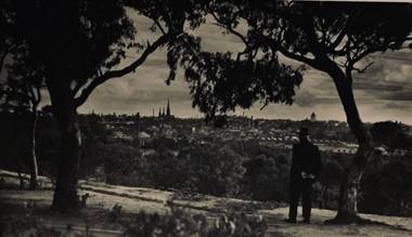
Photograph - Urban landscape, Henry Beater Christian, 1930s
Henry Christian (c.1809-91), the grandfather of the photographer, was one of the first settlers in Kew. He arrived in Victoria with his wife Agnes and son Orlando in 1855 on the Gypsy Queen. He established a rope-making business in Bulleen Road by 1858 but was declared insolvent two years later. In his final years, he was celebrated as one of the oldest living settlers of the district. His son, Orlando Henry Beater Christian (c.1853-1930) became a member of the Hawthorn Band and a foundation member of the Willsmere Swimming Club. Orlando and his wife Elizabeth had four children of which Henry Beater Christian (1886-1962) was the eldest.An item from an outstanding and diverse photographic collection, assembled by members of the Christian family of Pakington Street, Kew, comprising professional and amateur photography, depicting individuals, natural and settled environments and the interactions between these worlds. Many of the photographs vividly capture the worlds of three generations of men - Henry Christian, his son Orlando Henry Beater Christian, and his grandson of Henry Christian. The most important photographer was the youngest, Henry Christian, who was a keen explorer, not just of his immediate environment but also of the Victorian wilderness. His major opus is contained in two albums in which he records, sometimes in majestic detail and on other occasions the intimate features of the natural world. His photographic travels during the 1920s, often in solitary ramblings but on other occasions with companions, recall the heroic landscape photography of an earlier era, pioneered by Nicholas Caire. In addition to their aesthetic value, the albums are historically significant records within the State of Victoria, of what is now a distant point in time, and of places that have become radically altered through human intervention.Black and white photo of the rear view of a man in a hat standing under a tree on a hill looking across the Yarra River (unseen) towards Melbourne. The exhibition building and the spires of St Patrick’s Cathedral can be seen on the skyline. The man may be Orlando Henry Beater Christian. If all the spires are intact it must postdate 1939 when work begun in the early 1930s on the spires began. He may be standing on the edge of the Yarra Boulevard.melbourne skyline - 1930s, yarra boulevard -- kew (vic.), christian-washfold collection -
 Melbourne Tram Museum
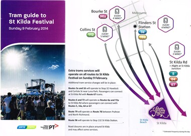
Pamphlet, Yarra Trams, "Tram guide to St Kilda Festival", Feb. 2014
Pamphlet - 3 fold DL full colour - titled on one side "Tram guide to St Kilda Festival" for Sunday 9 Feb. 2014 and on the other "Important Tram Service Changes" covering track maintenance work on St Kilda Road routes between Southbank Boulevard and Park St for Saturday 8 Feb. 2014. Shows relevant maps and re-routing of trams by Sturt St and Kingsway. Two copies held.trams, tramways, st kilda rd, trackwork, festival, st kilda -
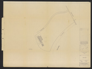 University of Melbourne, Burnley Campus Archives
Plan, Alexander Metherell, Library - Boulevard/Engineering Block, 1983
(1) Site Plan by Alexander Metherell Pty. Ltd. Job No BHC/1 Drawing No SP/3 dated Dec 1983. On reverse, Plan SP/3 Library - Boulevard." (2) 4 tracing paper copies with various annotations. (3) Tracing paper planting plan. (4) Coloured, laminated copy, Proposed Planting: Engineering Block and 2 sketches on tracing paper and paper. Also see B15.0352 for Full Report.alexander metherell, library -
 University of Melbourne, Burnley Campus Archives
Album - Colour slides, Burnley Views, 1966-1991
Contributor: T.H. KneenBox of 30 slides. Dates printed on slides. May 1966: (1) Rose Garden (now Herbaceous Border). (2) View from outside PRI towards Administration Building showing roses. (3) View of young trees? (4) View from Administration Building towards PSL. Dec 1966: (5) Yarra Boulevard with Burnley Campus on left. (6) View of greenhouses from Yarra Boulevard. Sept 1967: (7) Demonstration of root system of ? (8) Demonstration of root system of a strawberry plant. (9, 10) The Kneen children sitting in a felled tree. (11- 13) One of the Kneen girls by the Luffmann Ponds. (14,15) Principal's Residence with blossom tree. (16) Back of the Administration Building. (17) View of trees at Burnley? (18) Back of the Administration Building. (19-24) Inside Nursery. (25) Unveiling of plaque presented by the Burnley Horticultural Past Students Association for the 1991 Centenary of the College. Eric Littlejohn, ? Tom Kneen. (26) Float advertising Dookie Agricultural College.rose garden, administration building, trees, yarra boulevard, greenhouses, root system, strawberry plant, kneen family, children, luffmann ponds, principal's residence, nursery, burnley horticultural past students association, eric littlejohn, t.h. kneen, dookie agricultural college, garden views, plaque -
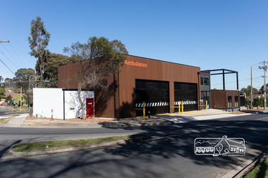 Eltham District Historical Society Inc
Photograph, Peter Pidgeon, Official opening of the new Eltham Ambulance Branch, Apex Way, Montmorency, 29 August 2018, 29 Aug 2018
Dignitaries included Ambulance Victoria CEO Tony Walker, Vicki Ward MP for Eltham and Jill Hennessey State Ambulance Services Minister The Eltham Apex Club conducted a Community Service Project (1965-1968) to raise funds for a new Ambulance Station to service the community. A site bounded by the intersection of Main Road, Grand Boulevard and Looker Road at Montmorency was purchased in 1969. In 1970, Eltham Shire Council undertook roadworks to construct Apex Way in preparation for the new station as well as duplicate Main Road, Lower Plenty, east of Grand Boulevard including the new Lower Plenty Bridge, which had been opened in November 1966, bordering with the City of Heidelberg. Diamond Valley Leader, September 5, 2018, p4. MONTMORENCY $1.6mil station unveiled A REVAMPED Montmorency ambulance station has been unveiled. State Ambulance Services Minister Jill Hennessy and Eltham State Labor MP Vicki Ward revealed the $1.6 million complex at the corner of Grand Boulevard and Apex Way in Montmorency. It replaces the 50-year-old station and now includes four ambulance bays, four rest and recline rooms, a large training room and offstreet parking for staff. “The community campaigned long and hard for this new ambulance station and I’m delighted to have stood with them all the way,” Ms Ward said. The latest quarterly performance data showed 90.4 per cent of ambulances in Banyule arrived within 15 minutes of Code 1 emergencies — up from 89.2 per cent three months earlier. Ms Hennessy said paramedics had worked in “cramped” facilities. “We’ve fixed that,” she said.55 born digital imagesambulance victoria ceo, apex way, apex-diamond valley ambulance station, eltham ambulance station, eltham apex club, jill hennessey, montmorency, mp for eltham, state ambulance services minister, tony walker, vicki ward -
Port Melbourne Historical & Preservation Society
Photograph - Friends of the Park float, Port Melbourne Festival, Pat Grainger, Feb 1989
This float was created by members of Friends of the Park, a group formed in 1987 against government proposals to turn the railway and reservation into a grand boulevard to service the proposed Sandridge City 'bayside' development. Members worked for months to make the decorations, added to a trailer. During the festival procession sausages were BBQ'd on the trailer and handed out to the crowd. On arrival at Murphy's Reserve all floats were put out of sight, and few saw the results of their efforts.One of 16 colour photos of Friends of the Park float for the February 1989 Port Melbourne Festival: Nellie Thackruh, Jan Fly and Andrea Ellis in background, finishing preparations in Raglan Streetcelebrations fetes and exhibitions, public action campaigns, jan fly, andrea ellis, nellie thackruh, friends of the park, port melbourne festival -
Port Melbourne Historical & Preservation Society
Photograph - Friends of the Park float, Port Melbourne Festival, Pat Grainger, Feb 1989
This float was created by members of Friends of the Park, a group formed in 1987 against government proposals to turn the railway and reservation into a grand boulevard to service the proposed Sandridge City 'Bayside' development. Members worked for months to make the decorations, added to a trailer. During the festival procession sausages were BBQ'd on the trailer and handed out to the crowd. On arrival at Murphy's Reserve all floats were put out of sight, and few saw the results of their efforts.One of 16 photos of Friends of the Park float for the February 1988 Port Melbourne Festival: Float construction at Station Street carport, 88 Ingles Street: Jan Fly and ?celebrations fetes and exhibitions, public action campaigns, town planning - proposals shelved - bayside, jan fly, friends of the park, port melbourne festival -
Port Melbourne Historical & Preservation Society
Photograph - Friends of the Park float, Port Melbourne Festival, Pat Grainger, Feb 1989
This float was created by members of Friends of the Park, a group formed in 1987 against government proposals to turn the railway and reservation into a grand boulevard to service the proposed Sandridge City 'bayside' development. Members worked for months to make the decorations, added to a trailer. During the festival procession sausages were BBQ'd on the trailer and handed out to the crowd. On arrival at Murphy's Reserve all floats were put out of sight, and few saw the results of their efforts.One of 16 photos of Friends of the Park float for the February 1989 Port Melbourne Festival: Float construction at Station Street carport, 88 Ingles Street: ?, Gary Ways (L), Amelia Finch (C), Anne Callaghan(R)celebrations fetes and exhibitions, public action campaigns, anne callaghan, gary, amelia finch, friends of the park, port melbourne festival -
Port Melbourne Historical & Preservation Society
Photograph - Friends of the Park float, Port Melbourne Festival, Pat Grainger, Feb 1989
This float was created by members of Friends of the Park, a group formed in 1987 against government proposals to turn the railway and reservation into a grand boulevard to service the proposed Sandridge City 'Bayside' development. Members worked for months to make the decorations, added to a trailer. During the festival procession sausages were BBQ'd on the trailer and handed out to the crowd. On arrival at Murphy's Reserve all floats were put out of sight, and few saw the results of their efforts.One of 16 photos of Friends of the Park float for the February 1989 Port Melbourne Festival: Float construction at 88 Ingles Stcelebrations fetes and exhibitions, public action campaigns, town planning - proposals shelved - bayside, anne callaghan, gary way, friends of the park, sandridge city development co pty ltd, scdc, port melbourne festival -
Port Melbourne Historical & Preservation Society
Photograph - Friends of the Park float, Port Melbourne Festival, Pat Grainger, Feb 1989
This float was created by members of Friends of the Park, a group formed in 1987 against government proposals to turn the railway and reservation into a grand boulevard to service the proposed Sandridge City 'bayside' development. Members worked for months to make the decorations, added to a trailer. During the festival procession sausages were BBQ'd on the trailer and handed out to the crowd. On arrival at Murphy's Reserve all floats were put out of sight, and few saw the results of their efforts.One of 16 photos of Friends of the Park float for the February 1989 Port Melbourne Festival: Float construction at Station Street carport - Jemma and Marilyn Tulloch with flower decorationscelebrations fetes and exhibitions, public action campaigns, gemma tulloch, marilyn tulloch, friends of the park, port melbourne festival -
Port Melbourne Historical & Preservation Society
Photograph - Friends of the Park float, Port Melbourne Festival, Pat Grainger, Feb 1989
This float was created by members of Friends of the Park, a group formed in 1987 against government proposals to turn the railway and reservation into a grand boulevard to service the proposed Sandridge City 'bayside' development. Members worked for months to make the decorations, added to a trailer. During the festival procession sausages were BBQ'd on the trailer and handed out to the crowd. On arrival at Murphy's Reserve all floats were put out of sight, and few saw the results of their efforts.One of 16 photos of Friends of the Park float for the February 1989 Port Melbourne Festival: Preparations for the procession forming by the Raglan Street flats - Gary Way (L), Michaela Sammit, Marilyn and Gemma Tulloch.celebrations fetes and exhibitions, public action campaigns, gemma tulloch, marilyn tulloch, jan fly, michaela sammit, gary, friends of the park, port melbourne festival -
Port Melbourne Historical & Preservation Society
Photograph - Friends of the Park float, Port Melbourne Festival, Pat Grainger, Feb 1989
This float was created by members of Friends of the Park, a group formed in 1987 against government proposals to turn the railway and reservation into a grand boulevard to service the proposed Sandridge City 'bayside' development. Members worked for months to make the decorations, added to a trailer. During the festival procession sausages were BBQ'd on the trailer and handed out to the crowd. On arrival at Murphy's Reserve all floats were put out of sight, and few saw the results of their efforts.One of 16 photos of Friends of the Park float for the February 1989 Port Melbourne Festival: Preparations for the procession forming by the Raglan Street flats - Gary Way (L) , Marilyn Tulloch, Jan Fly (R) and others.celebrations fetes and exhibitions, public action campaigns, gemma tulloch, marilyn tulloch, jan fly, michaela sammit, gary, friends of the park, port melbourne festival -
Port Melbourne Historical & Preservation Society
Photograph - Friends of the Park float, Port Melbourne Festival, Pat Grainger, Feb 1989
This float was created by members of Friends of the Park, a group formed in 1987 against government proposals to turn the railway and reservation into a grand boulevard to service the proposed Sandridge City 'bayside' development. Members worked for months to make the decorations, added to a trailer. During the festival procession sausages were BBQ'd on the trailer and handed out to the crowd. On arrival at Murphy's Reserve all floats were put out of sight, and few saw the results of their efforts.One of 16 photos of Friends of the Park float for the February 1989 Port Melbourne Festival: Preparations for the procession forming by the Raglan Street flats - star of the float, Nellie Thackruhcelebrations fetes and exhibitions, public action campaigns, nellie thackruh, friends of the park, port melbourne festival -
Port Melbourne Historical & Preservation Society
Photograph - Friends of the Park float, Port Melbourne Festival, Pat Grainger, Feb 1989
This float was created by members of Friends of the Park, a group formed in 1987 against government proposals to turn the railway and reservation into a grand boulevard to service the proposed Sandridge City 'bayside' development. Members worked for months to make the decorations, added to a trailer. During the festival procession sausages were BBQ'd on the trailer and handed out to the crowd. On arrival at Murphy's Reserve all floats were put out of sight, and few saw the results of their efforts.One of 16 colour photos of Friends of the Park float for the February 1989 Port Melbourne Festival: Preparations for the procession forming by the Raglan Street flats - Jan Fly, Andrea Ellis and Marilyn Tullochcelebrations fetes and exhibitions, public action campaigns, jan fly, andrea ellis, marilyn tulloch, friends of the park, port melbourne festival -
Port Melbourne Historical & Preservation Society
Photograph - Friends of the Park float, Port Melbourne Festival, Pat Grainger, Feb 1989
This float was created by members of Friends of the Park, a group formed in 1987 against government proposals to turn the railway and reservation into a grand boulevard to service the proposed Sandridge City 'bayside' development. Members worked for months to make the decorations, added to a trailer. During the festival procession sausages were BBQ'd on the trailer and handed out to the crowd. On arrival at Murphy's Reserve all floats were put out of sight, and few saw the results of their efforts.One of 16 colour photos of Friends of the Park float for the February 1989 Port Melbourne Festival: Preparations for the procession forming by the Raglan Street flats - Nellie Thackruh and Maree Menzelcelebrations fetes and exhibitions, public action campaigns, andrea ellis, friends of the park, nellie thackruh, port melbourne festival -
Port Melbourne Historical & Preservation Society
Photograph - Friends of the Park float, Port Melbourne Festival, Pat Grainger, Feb 1989
This float was created by members of Friends of the Park, a group formed in 1987 against government proposals to turn the railway and reservation into a grand boulevard to service the proposed Sandridge City 'bayside' development. Members worked for months to make the decorations, added to a trailer. During the festival procession sausages were BBQ'd on the trailer and handed out to the crowd. On arrival at Murphy's Reserve all floats were put out of sight, and few saw the results of their efforts.One of 16 colour photos of Friends of the Park float for the February 1989 Port Melbourne Festival: Float in Bay Street, Robert Frost BBQing, Nellie Thackruh the starcelebrations fetes and exhibitions, public action campaigns, friends of the park, robert frost, nellie thackruh, port melbourne festival -
Port Melbourne Historical & Preservation Society
Photograph - Friends of the Park float, Port Melbourne Festival, Pat Grainger, Feb 1989
This float was created by members of Friends of the Park, a group formed in 1987 against government proposals to turn the railway and reservation into a grand boulevard to service the proposed Sandridge City 'bayside' development. Members worked for months to make the decorations, added to a trailer. During the festival procession sausages were BBQ'd on the trailer and handed out to the crowd. On arrival at Murphy's Reserve all floats were put out of sight, and few saw the results of their efforts.One of 16 colour photos of Friends of the Park float for the February 1989 Port Melbourne Festival: Float in Bay Street, Robert Frost BBQingpublic action campaigns, celebrations fetes and exhibitions, friends of the park, robert frost, port melbourne festival -
Port Melbourne Historical & Preservation Society
Photograph - Friends of the Park float, Port Melbourne Festival, Pat Grainger, Feb 1988
This float was created by members of Friends of the Park, a group formed in 1987 against government proposals to turn the railway and reservation into a grand boulevard to service the proposed Sandridge City 'bayside' development. Members worked for months to make the decorations, added to a trailer. During the festival procession sausages were BBQ'd on the trailer and handed out to the crowd. On arrival at Murphy's Reserve all floats were put out of sight, and few saw the results of their efforts.One of 16 colour photos of Friends of the Park float for the February 1988 Port Melbourne Festival: Nellie Thackruh and Robert Frost with his BBQ on float, on Graham Street overpasscelebrations fetes and exhibitions, public action campaigns, friends of the park, nellie thackruh, robert frost, port melbourne festival -
Port Melbourne Historical & Preservation Society
Photograph - Friends of the Park float, Port Melbourne Festival, Pat Grainger, Feb 1989
This float was created by members of Friends of the Park, a group formed in 1987 against government proposals to turn the railway and reservation into a grand boulevard to service the proposed Sandridge City 'bayside' development. Members worked for months to make the decorations, added to a trailer. During the festival procession sausages were BBQ'd on the trailer and handed out to the crowd. On arrival at Murphy's Reserve all floats were put out of sight, and few saw the results of their efforts.One of 16 colour photos of Friends of the Park float for the February 1989 Port Melbourne Festival: Banner and children that preceded the float, at Murphy's Reserve. Jemma Tulloch and Rose Callaghan left foregroundcelebrations fetes and exhibitions, public action campaigns, friends of the park, gemma tulloch, rose callaghan, port melbourne festival -
Port Melbourne Historical & Preservation Society
Photograph - Friends of the Park float, Port Melbourne Festival, Pat Grainger, Feb 1989
This float was created by members of Friends of the Park, a group formed in 1987 against government proposals to turn the railway and reservation into a grand boulevard to service the proposed Sandridge City 'bayside' development. Members worked for months to make the decorations, added to a trailer. During the festival procession sausages were BBQ'd on the trailer and handed out to the crowd. On arrival at Murphy's Reserve all floats were put out of sight, and few saw the results of their efforts.One of 16 colour photos of Friends of the Park float for the February 1989 Port Melbourne Festival: Float has reached Murphy's Reserve. Nellie Thackruh, Robert Frost, Sheila Callaghan, Jemma Tulloch and Kay Frostcelebrations fetes and exhibitions, public action campaigns, friends of the park, gemma tulloch, rose callaghan, port melbourne festival -
Port Melbourne Historical & Preservation Society
Photograph - Friends of the Park float, Port Melbourne Festival, Pat Grainger, Feb 1989
This float was created by members of Friends of the Park, a group formed in 1987 against government proposals to turn the railway and reservation into a grand boulevard to service the proposed Sandridge City 'bayside' development. Members worked for months to make the decorations, added to a trailer. During the festival procession sausages were BBQ'd on the trailer and handed out to the crowd. On arrival at Murphy's Reserve all floats were put out of sight, and few saw the results of their efforts.One of 16 colour photos of Friends of the Park float for the February 1989 Port Melbourne Festival: Float has reached Murphy's Reserve. Nellie Thackruh, the starcelebrations fetes and exhibitions, public action campaigns, friends of the park, nellie thackruh, port melbourne festival -
 University of Melbourne, Burnley Campus Archives
Album - Black and white and colour prints, Brian Ward, Freeway Construction, 1963-1972
(1) 14 black and white photographs showing views of where the Freeway would be going through near Burnley Gardens. (2) 2 photographs of views of the Yarra River near Burnley Gardens. (3) Aerial photograph of construction of the Freeway near Burnley Gardens and Yarra Boulevard. (4) 8 colour photographs of construction work in and over the River Yarra near the railway bridge. "Brian Ward Freeway Construction" handwritten on cover of folder. Student Dux 1973.freeway, burnley gardens, yarra river, yarra boulevard, river yarra, brian ward, aerial photographs -
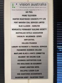 Vision Australia
Photograph - Image, Mel Robbins, Plaques at Newcastle office
Silver plaque with black writing mounted on board inside black frame, and silver plaque with black writing. Both list the companies that financially supported the Newcastle office for Vision Australia (formerly the Royal Blind Society of New South Wales). The first plaque reads: Vision Australia Blindness and low vision services Vision Australia is proudly supported in the Hunter by: Ian Paul Prime Television Hunter Readymixed Concrete Pty Ltd Port Waratah Coal Services Limited Blue Illusion - Hamilton Newcastle Permanent Building Society Australian Hotels Association Sandalyn Wilderness Estate AmpControl Colleen Praniess Lidbury Retirement & Financial Services Passmores Business College Maitland Black & White Committee Belmont 16ft Sailing Club Cessnock Supporters Club The Boulevard on Beaumont Sydney Junction Hotel Gallipoli Legion Club VDB Chartered Accountants Salvation Army - McIntosh Trust The second plaque reads: Royal Blind Society vision to share This Client Service Centre was made possible thanks to generous support from Ian Paul as well as the following organisations Prime Television Newcastle Knights Hunter Water Western Suburbs (Newcastle) Leagues Club Management Advisors Corporation Drayton Building & Construction The Plan Centre Hunter Land2 images of plaques displayed at the Newcastle officeVision Australia Blindness and low vision services Vision Australia is proudly supported in the Hunter by: Ian Paul Prime Television Hunter Readymixed Concrete Pty Ltd Port Waratah Coal Services Limited Blue Illusion - Hamilton Newcastle Permanent Building Society Australian Hotels Association Sandalyn Wilderness Estate AmpControl Colleen Praniess Lidbury Retirement & Financial Services Passmores Business College Maitland Black & White Committee Belmont 16ft Sailing Club Cessnock Supporters Club The Boulevard on Beaumont Sydney Junction Hotel Gallipoli Legion Club VDB Chartered Accountants Salvation Army - McIntosh Trust Royal Blind Society vision to share This Client Service Centre was made possible thanks to generous support from Ian Paul as well as the following organisations Prime Television Newcastle Knights Hunter Water Western Suburbs (Newcastle) Leagues Club Management Advisors Corporation Drayton Building & Construction The Plan Centre Hunter Landvision australia, royal blind society of nsw, plaques -
 Kew Historical Society Inc
Map, MMBW, MMBW Plan No.39 Kew & Heidelberg, 1900-1910
The Melbourne and Metropolitan Board of Works (MMBW) was established by an act of the Victorian Parliament in 1890 to prepare for and to implement a sewerage and water reticulation system across what was then inner Melbourne, its surrounding and middle distance suburbs, including Kew. The MMBW was disbanded in 1991.The map collection of the Kew Historical Society has at its core the historic maps assembled and originally stored in the City Engineer's Department of the City of Kew. These include maps in a number of scales. The vast majority of maps were produced by the MMBW in the first two decades of the twentieth century, and are solid working maps, backed by linen for durability. These maps are historically significant to Kew, the City of Boroondara and to the history of the development of state utilities in Victoria. A number of the Kew maps have additional details added by former municipal officers, including the levels reached by various floods. As these were working documents, information was added to them long after the period of their initial production and distribution.Early map of part of the Borough of Kew, created in the first decade of the twentieth century, at a scale 160 ft to 1 inch. The map covers what was then the north western section of Kew, bordered on its north by Wills Street and the Kew Lunatic Asylum, in the west by the River Yarra [and the later added Yarra Boulevard] , by Princess Street in the East and Holroyd Street in the south. The map shows the extent of urban development by that time, prominent institutions and the outlines of built structures in the municipality. Contour lines were added in ink to the map at a later stage.MELBOURNE AND METROPOLITAN BOARD OF WORKS / PLAN NO. 39 / KEW & HEIDELBERGmelbourne & metropolitan board of works, mmbw maps, mmbw plans, borough of kew, cartography -
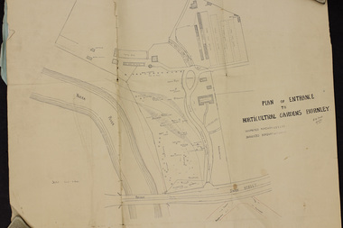 University of Melbourne, Burnley Campus Archives
Plan, Plan of Entrance to Horticultural Gardens Burnley, 1932
Copy of plan photographed at the Public Records Office Victoria. (1) Hand drawn plan signed by A.W. Jessep 8/12/32 with 'Suspected Roadway' and ' Suggested Roadway'. Scale 1 inch - 1 chain. Trees on East side named. (2) Memorandum to The Agricultural Superintendent dated 08.12.1932 'Re Proposed Boulevard Along the River Yarra' from the Principal A.W. Jessep. Plan had been to put road through the Lagoon Paddock and he suggested the route outside the Burnley College grounds.prov, burnley gardens, a.w. jessep