Showing 4478 items
matching the point
-
 Phillip Island and District Historical Society Inc.
Photograph, 1990
This photograph taken by Jack Eddy for the Phillip Island Cemetery Trust. This is the grave of Capt. William Grossard who was accidentally shot on 17 December 1868. The grave is situated at Grossard point, Ventnor, Phillip IslandPhotograph of grave of Captain William Philip Grossard, at Grossard Point, Ventnor, Phillip Island"Sacred to the memory of William Philip Grossard, 1812 - 1868"local history, photography, photographs, slides, film, captain grossard's grave, coloured photograph, grossard point ventnor, phillip island, captain william grossard -
Phillip Island and District Historical Society Inc.
Photograph, 1990
This photograph taken by Jack Eddy for the Phillip Island Cemetery Trust. This is the grave of Capt. William Grossard who was accidentally shot on 17 December 1868. The grave is situated at Grossard point, Ventnor, Phillip IslandPhotograph of grave of Captain William Phillip Grossard at Grossard Point, Ventnor, Phillip Island"Sacred to the memory of William Philip Grossard, 1812 - 1868local history, photography, photographs, slides, film, captain grossard's grave, coloured photograph, grossard point ventnor, phillip island, captain william grossard -
Phillip Island and District Historical Society Inc.
Photograph, 1990
This photograph taken by Jack Eddy for the Phillip Island Cemetery Trust. This is the grave of Capt. William Grossard who was accidentally shot on 17 December 1868. The grave is situated at Grossard point, Ventnor, Phillip IslandPhotograph of grave of Captain William Phillip Grossard at Grossard Point, Ventnor, Phillip Island"Sacred to the memory of William Philip Grossard, 1812 - 1868local history, photography, photographs, slides, film, captain grossard's grave, black & white photograph, grossard point ventnor, phillip island, captain william grossard -
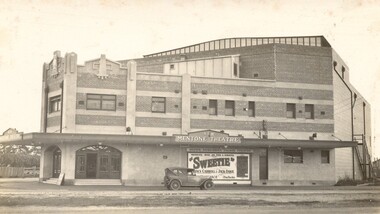 City of Kingston
Photograph - Digital image, Black and white, c.1928
Image of the newly opened Mentone Picture Theatre located on Point Nepean Road in Mentone. Local picture theatres abounded in the in the suburbs of Kingston from the 1920s through to the late 1950s. The New Mentone Picture Theatre was dreamt up and developed by Albert Lydford who along with other promoters, formed a company that provided the finance for the erection of a large cinema right at the junction of Balcombe Road and Point Nepean Road. The New Mentone Picture Theatre operated in competition with a council owned facility on Brindisi Street and within three years of opening, the council theatre was closed. The New Mentone Theatre flourished until the late 1950s. It offered three changes of program each week. Two movies screened on Mondays and Tuesdays. On Wednesday a new bill went on for just one night, and then the main feature of the week, a movie the likes of Casablanca, was shown from Thursday through to Saturday. During its heyday there were full houses almost weekly. Saturday night shows were often booked out in advance and some families had permanent bookings at weekends. Locals treated the place as a centre of social activity, a venue for an enjoyable night out that did not involve great expense or long travel times. The advent of television in the 1950's, saw the theatre close forever in 1960.Sepia toned image of the New Mentone Picture Theatre, located on Point Nepean Road, Mentone.theatre, movies, mentone, entertainment -
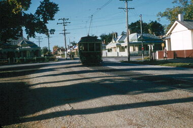 Ballarat Tramway Museum
Slide - 35mm slide/s, Ben Parle, 8/04/1958 12:00:00 AM
Kodachrome Transparency - 35mm slide - cardboard mount, with one side with red border and words "Kodachrome Transparency / Processed by Kodak" top and bottom. Photo taken by Ben Parle 8/4/1958, date stamped onto slide. Has slide No. "21" stamped in red in top corner. Photo of Ballarat 12, Ripon St, about to cross Mair St. inbound from View Point. Photo taken after tram has passed photographer. Note gravel surface either side of tram track. "View Point line" / "8-4-58"tramways, trams, view point, ripon st, tram 12 -
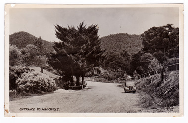
 Marysville & District Historical Society
Photograph (item) - Colour tinted photograph, Valentine Publishing Co. Pty. Ltd, The Road to Cumberland Valley, Marysville. No. 1, 1923-1963
An early colour tinted photograph of the intersection of the Buxton Marysville Road and the Marysville-Wood's Point Road.An early photograph of the Buxton Marysville Road and the Marysville-Wood's Point Road intersection. The Marysville-Buxton Road joins the Maroondah Highway which leads to Alexandra. The Marysville-Woods Point Road was originally part of the Yarra Track, constructed in the early 1860s to provide access between Healesville and the Woods Point Goldfields. Despite the steep terrain and engineering difficulties, the Yarra Track soon became a busy route used by pack horses, horse-drawn drays, and wagons. Today this sealed mountain road is a popular scenic drive between Marysville and Warburton. On the right of the photograph can be seen 'The Crossways Hotel' which is circa 1920 and one of the oldest buildings still standing in Marysville. 'The Crossways Hotel' survived the 2009 Black Saturday bushfires, through the efforts of the owner using buckets of water from the nearby Steavenson River. In the background can be seen the Poontawan Guest House which later became the Marysville Chalet Guest House which was on the site of the original Steavenson's Hotel. That guest house no longer exists and the Christ Church stands on the land where the guest house once stood. This photograph was published by the Valentine Publishing Co Pty. Ltd as a souvenir of Marysville.marysville, victoria, marysville chalet guest house, crossways hotel, christ church marysville, poontawan guest house, steavenson's hotel, valentine publishing co, souvenir, yarra track, wood's point road, mining, buxton-marysville road, marysville-wood's point road, maroondah highway, alexandra -
 Stawell Historical Society Inc
Photograph, Dunmunkle Creek where it originally connected to Wimmera River 2017 -- Coloured
Colour Photo of Dunmunkle Creek originally connected to Wimmera River at this point. Just before the Glenorchy Weir. 2017Colour photograph of what looks to be a dry creek bed. Timber on creek bank. Dunmunkle Creek originally connected to Wimmera River at this point. Just before the Glenorchy Weir (Photo taken 2017) water -
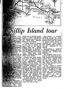 Phillip Island Conservation Society Inc.
Work on paper - Photocopy of newspaper cutting, "Phillip Island tour", circa 1950s?
The article relates the journalist's visit to Phillip Island, starting from Melbourne and describing features along the way, then at San Remo on mainland side of Phillip Island bridge, then Newhaven on the other. Other places visited include the main town of Cowes, the jetty and beach there, and the Nobbies (Point Grant), with views of the Seal Rocks offshore through telescope at the Nobbies. The writer also visited Summerland beach, described as a surf beach, with penguin and mutton bird rookeries. While not specifically referring to the Penguin Parade, the writer says the spectacle of seeing the penguins coming ashore is not to be missed. The brief military colony at Rhyll and the first Victorian 'garden' planted at Churchill Island in 1801 are also mentionedArticle is significant because it is an early (1950s?) tourist guide to Phillip Island's most popular tourist destinations. 3 column text under map of Phillip Island. Black print on white paper. phillip island, newhaven, , westernport, surf beaches phillip island, summerland beach, penguins, mutton birds, the nobbies, point grant, seal rocks, cowes, nobbies blowhole, rhyll, churchill island, nobbies telescope -
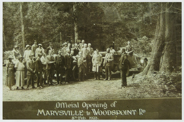 Marysville & District Historical Society
Photograph (Item) - Black and white photograph, Official Opening of MARYSVILLE to WOODSPOINT RD 5th Feb, 1923, 05-02-1924
An early black and white photograph which was taken after the ceremonial re-opening of the Marysville-Wood's Point Road in 1924. The date of 1923 on the photograph is incorrect.An early black and white photograph which was taken after the ceremonial re-opening of the Marysville-Wood's Point Road in 1924. The date of 1923 on the photograph is incorrect. The Marysville-Woods Point Road was originally part of the Yarra Track, constructed in the early 1860s to provide access between Healesville and the Woods Point Goldfields. Despite the steep terrain and engineering difficulties, the Yarra Track soon became a busy route used by pack horses, horse-drawn drays, and wagons. Today this sealed mountain road is a popular scenic drive between Marysville and Warburton.Official Opening of/ MARYSVILLE to WOODSPOINT RD/ 5th Feb, 1923marysville-wood's point road, marysville, wood's point goldfields, healesville, yarra track, warburton, the argus -
 Lakes Entrance Historical Society
Postcard - Princes Highway around Jemmy's Point
Princes Highway around Jemmy's Point . Unsealed road and post and rail fence. Bullock Island and the entrance in the distance c1925Black and white photograph of Princes Highway around Jemmy's Point . Unsealed road and post and rail fence. Bullock Island and the entrance in the distance waterways, topography, islands, roads and streets -
Glenelg Shire Council Cultural Collection
Photograph - Photograph - Main Breakwater construction, Portland, Jul-54
Port of Portland Authority ArchivesBack: PHT Purple Stamp Print No. 4/39 Neg No. 260 Date Taken 14/7/54 Subject Main Breakwater from Battery Pointport of portland archives, harbour, portland, main breakwater, construction -
 Kiewa Valley Historical Society
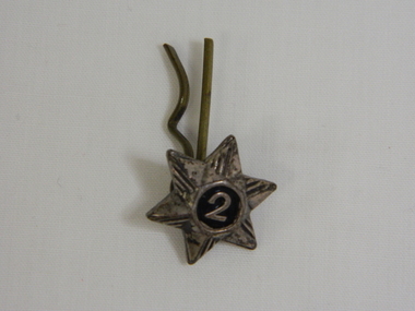
Badge - Girl Guide Service
Girl Guides Service Badge. The green felt at the back of the badge indicates it was a Girl Guides badge - (brown felt indicating a Brownies badge). The number 2 indicates the owner was in her 2nd year as a member of the Girl Guide Club.Historical: Provenance: The Davies family lived at Tawonga in the Kiewa Valley. The badge indicates that a member of the family was a member in her second year of Girl Guides - Wilma who was heavily involved in the Girl Guide movement or her daughter, Kerrie who was a member of the Girl Guides.A Girl Guide Service Badge. Brass star shaped with 6 points. Half of each point has 2 embossed lines from centre circle towards the point. In the centre is a circle coloured black at the centre of which is a brass number 2. The 2 stands out from the rest as it is raised from the flat circle which in turn is raised from the points which taper down to what would be a flat base but the badge is hollow. At the back of the star is a brass loop to which is attached a hair clip like pin - with a straight edge and a bumpy edge.(split pin attachment) A green felt circular pad with a central hole is attached.The 2 embossed lines on each half of each point of the star. The number 2 in the black circle. badge. star badge. numismatics. equipment. rank. pip. kiewa valley. tas davies., girl guides. wilma davies. kerrie davies. tawonga -
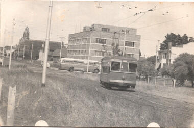
 Ballarat Tramway Museum
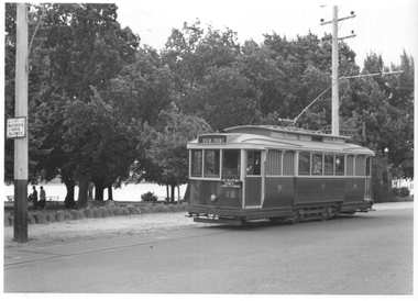
Photograph - Ballarat tram 18 - Lake View, Ken Winney, 12/1949
The photograph shows SEC Ballarat tram No. 18 in Wendouree Parade at a location opposite the View Point Hotel. The "gazebo" at this location can be seen behind the tram. The tram has the destination of View Point and an auxiliary sign of "Lake View Point Only - connect with launches". On the left side of the photo is a highway advisory sign "Motorists Drive Slowly" Photo by I K Winney of Sydney, 12/1949.Yields information about tram 18 and the Lake View route.Black and white photograph with photographers details on rear."No. 18 at View Point terminus, note supplementary sing re ferry connection across Lake Wendouree, Ballarat, 12/1949, I K Winney"tramcars, tram 18, wendouree parade, lake view, road signs -
 City of Kingston
Pamphlet - Black and white, J. F. Brady, The Hill Estate, Highett, c. 1905
Sales plan for land in the suburb of Highett, bounded by Sandford Street, Turner Street and Point Nepean RoadThe developing urban area of Highett within the City of Kingston. This land sale pamphlet illustrates the subdivision of land within the municipality and the changing demographic of the district as new houses are constructed close to infrastructure.Black and white pamphlet advertising for sale the Hill Estate, Highett. Incorporates a map of the estate bordered by Sandford Street, Turner Street and Point Nepean Road.Handwritten in grey pencil on reverse: The Hillland sales, highett, estate -
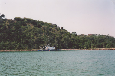 Lakes Entrance Historical Society
Photograph - Dredge on Gippsland Lakes, M Holding, 2008 c
dredge working on edge of lake below Jemmys Point. Glimpse of houses on Kalimna Heights in distance Lakes Entrance VictoriaColour photograph showing dredge working on edge of lake below Jemmys Point. Glimpse of houses on Kalimna Heights in distance Lakes Entrance Victoria waterways, topography, dredges -
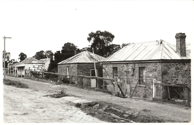 Bendigo Historical Society Inc.
Photograph - HARVEY TOWN: EAGLEHAWK, 1969
black and white photograph ( proof listed as 133 b ) 3 stone houses with corrugated iron roofs, house at left has verandah with 4 posts and weatherboard addition at back with chimney. Central building has one window facing street, 1 door at side. Right hand building has 2 windows facing street and central door, brick chimney, dilapidated wire fence and gate. On back in ball point pen ' Harvey Town/February 1969'on back in ball point pen ' Harvey Town, February 1969cottage, miners -
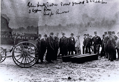 St Kilda Historical Society
Photograph, Exhumation of Glen Huntly Pioneers, 27/08/1898
Exhumation of Glen Huntly Pioneers at Point Ormond on 27 August 1898black and white photograph accompanied by a copyGlenhuntly road, Point Ormond to St Kilda line. 3 coffin row, ready for removal. Apps Undertaker. Robe st St Kilda -
Glenelg Shire Council Cultural Collection
Photograph - Photograph - Main Breakwater construction, Portland, Nov-54
Port of Portland Authority ArchivesFront: Main Breakwater From BAttery Point showing reclamation (typed) 2/11/54 Back: Purple PHT Stamp - Print No 4/45 Neg 284 Date Take 2/11/54 SUBJECT Main B/water from Battery Pt. Showing Reclamation.port of portland archives, main breakwater, battery point, portland harbour, reclamation, harbour development -
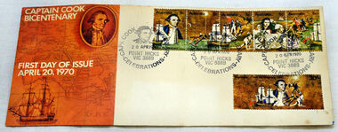 Orbost & District Historical Society
first day cover, Australia Post, April 1970
The Point Hicks cancel was used 8,269 times on the commemorative covers dated 20th April 1970. The first day cover commemorates the bicentenary of Cook's sighting of Point Hicks.When sailing along the coast of what is today southern Victoria, Cook recorded in his journal in April 1770 that he had named "The Southernmost Point of land we had in sight as Point Hicks, because Leiut Hicks, was the first who discoverd this land." This was the first European name recorded during that Endeavour voyage to be applied to a feature on the east coast of Australia. There is no longer a post office at Point Hicks and was possibly a temporary one used only for this issue.A first day issue envelope with stamps. Produced to commemorate the sighting of Point Hicks by Captain James Cook 0n 20 April 1770. It is a large cover with a strip of 5x 5c & a single 30c stamps. first-day-cover cook-james stamps philately point-hicks -
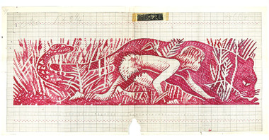 RMIT Design Archives
Mixed media - Textile Design Sample, Design for Clothing Label, 1958
Cash's first began manufacturing name tags, woven badges and woven labels in Australia in 1913, and since then countless Cash's labels have been sewn onto school and club jumpers. The Boy Scouts commissioned this point paper design featuring a boy, puma and snake. It is inspired by imagery from Kipling’s Jungle Book.Point paper design featuring boy, puma and snake. Corresponding clothing label attachedtextile design, design -
 Melbourne Tram Museum
Photograph - X class 217 at Point Ormond, 15-1-1954
The photograph shows X class 217 at Point Ormond terminus in Glen Huntly Road with a MMTB bus passing in the background. Photographer unknown, dated 15-1-1954.Yields information the Point Ormond terminus in 1954.Black and white photograph with notes on the rear.In ink on rear "Birney car 217,at Point Ormond 15-1-54, with MMTB bus in the background" and "1037".tramcars, tramways, point ormond, x class, tram 217 -
 Marysville & District Historical Society
Postcard (item) - Black and white postcard, Valentine Publishing Co. Pty. Ltd, Entrance to Marysville V.11, 1923-1963
An early black and white photograph of the Marysville-Wood's Point Road at the corner with Murchison Street in Marysville in Victoria.An early black and white photograph of the Marysville-Wood's Point Road at the corner with Murchison Street in Marysville in Victoria. This postcard was published by the Valentine Publishing Co. Pty. Ltd. as a souvenir of Marysville.VALENTINE'S/ POST CARD/ A GENUINE PHOTOGRAPHmarysville, victoria, postcard, valentine publishing co, souvenir, murchison street, marysville-wood's point road -
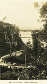 Lakes Entrance Historical Society
Postcard - The New Road Lakes Entrance, 1922 c
Also three postcards showing different views of the road around Jemmys Point 05281.1, .2 and .3Black and white postcard showing view of new alignment of the Princes Highway on Jemmys Point and part of the original high steep road approaching Lakes Entrance VictoriaThe New Road Lakes Entrance waterways, roads and streets -
 Bendigo Historical Society Inc.
Domestic Object - SEWING AIDS: BOOK OF SEWING NEEDLES
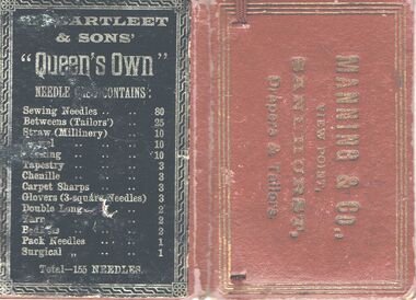
Red cardboard Wallet containing sewing needles - front shows in gold letters ' Manning & Co , View Point , Sandhurst , Drapers and Tailors / inside shows blue label with silver lettering ' W . Bartleet & Sons ' Needles First order of merit , Adelaide Jubilee Exhibition , 1887 Eleven gold and other prize medals , Superfine Sewing needles , 5 , 3/7 , 4/8 , 6 / needles are rusty / back of wallet black label with silver type Bartleet & Sons 'Queen's Own '.Manning & Co , View Point , Sandhurst / W . Bartleet & Sons 'handcrafts, needlework equipment, ' manning & co , view point , sandhurst drapers and tailors, /' w . bartleet & sons ' needles first order of merit , adelaide jubilee exhibition , 1887 / bartleet & sons 'queen's own ' -
Glenelg Shire Council Cultural Collection
Postcard - Postcard - Portland Harbour, Portland, Victoria, n.d
Black and white photo postcard. View of Portland Harbour from Battery Point. Ocean pier, with ship berthed, railway pier and fishernen's breakwater, cannon in foreground.Front: 'Portland Harbour from Bathing Battery Point', white script bottom left. 'Bathing' crossed out with black biro, 'Battery' written in black biro beneath -
 Lakes Entrance Historical Society
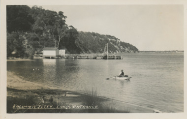
Postcard - Kalimna Jetty Lakes Entrance Victoria, H D Bulmer, 1930 c
Kalimna Jetty showing two sheds on jetty man rowing boat on lake Jemmys Point in distance Lakes Entrance VictoriaBlack and white postcard of Kalimna Jetty showing two sheds on jetty man rowing boat on lake Jemmys Point in distance Lakes Entrance VictoriaKalimna Jetty Lakes Entrancejetties, waterways, boats and boating -
 Lakes Entrance Historical Society
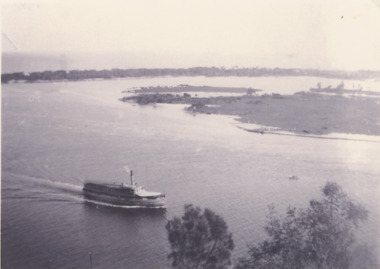
Photograph - SS Gippsland on Gippsland Lakes, 1927
postcard taken from Jemmys Point with SS Gippsland in the Narrows passing Rigby Island, Snake Island and outer barrier in distanceBlack and white copy of postcard taken from Jemmys Point with SS Gippsland in the Narrows passing Rigby Island, Snake Island and outer barrier in distancevegetation, waterfront, gippsland lakes, topography, boats and boating -
 Melbourne Tram Museum
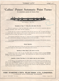
Pamphlet - "Collins Automatic Point Turner", Forest City Electric Co. Limited, c1940s
Four-page printed brochure with illustrations 1940’s? describing the Point turning mechanism with illustrations, of the equipment, method of operation advantages, wiring, the street box and curb (kerb) control box. This type was used for many years at the intersection of Swan and Church Sts Richmond. Published by the Forest City Electric Co. of Manchester.Yields information about the Forest City Collins Point turners.Four page Pamphlet or Brochure Forest City No. 18T, "Collins Patent Automatic Point Turner".trams, tramways, forest city, points