Showing 876 items
matching tide
-
 National Vietnam Veterans Museum (NVVM)
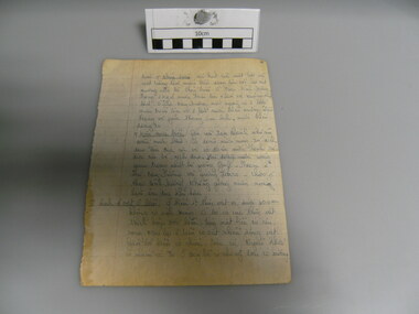
Document, System of Tides
Very old page from exercise book in very neat manuscript which describes the System of Tides. But not of Vietnam rather The Gulf Stream and Atlantic OceanRecovered from an abandoned bunker systempage from exercise book, system of tides, propaganda, nva/vc, psycological warfare -
 Lakes Entrance Regional Historical Society (operating as Lakes Entrance History Centre & Museum)
Photograph, 1/06/1990 12:00:00 AM
Also two black and white photographs taken at same event showing Albert Mullett, Jack Jacko Johnson, Corey Simpson, Mark Boon: Daryl Archibald of Esso, Shane Doyle crew member and Brian Miers Minister of Aboriginal Affairs 04819.1 5 x 3 cmBlack and white photograph taken at official ceremony naming the Esso oil rig supply vessel Kurnai Tide at Eastern Wharf Lakes Entrance Victoriacelebrations, local government, buildings -
Glenelg Shire Council Cultural Collection
Photograph - Photograph - Henty Beach, Aug-89
Port of Portland Authority ArchivesBack: 'Yacht Club / Henty Beach Slip and infill August 1989 (v. high tides)port of portland archives, portland harbour, henty beach -
 Churchill Island Heritage Farm
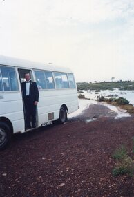
Photograph - Photograph of man standing at minibus door
Churchill Island Heritage Farm has a large photograph collection.Colour photograph of a man wearing a black suit and bow tie with a white boutonniere standing at the door of a white minibus parked with a view of mudflats in high tide in the background. Catalogue number written on reverse in pencil churchill island, photograph -
 Lakes Entrance Regional Historical Society (operating as Lakes Entrance History Centre & Museum)
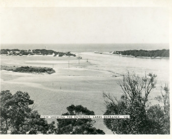
Photograph, Martin Orville, 1940c
Another copy Black and white 7 x 8.5 with inscription'View showing the Entrance, Lakes Entrance, Vic'Black and white photograph of Bullock Island, the New Works, township and entrance from Bass Strait to the Gippsland Lakes. Taken at high tide. Lakes Entrance Victoriaislands, waterways, bridges, topography -
Phillip Island and District Historical Society Inc.
Photograph, 1968
Part of an album compiled and donated by Mrs Helen Jansson. Construction of second Phillip Island to San Remo Bridge 1968/69.Close up of first decking in place - at full tide from Phillip Island side. Span projecting into air middle right with cranes at sea level middle right.John Squire Photography.local history, photography, photographs, slides, film, civil engineering, bridges, phillip island bridge 1968, black & white photograph, mrs helen jansson, phillip island bridge -
 Churchill Island Heritage Farm
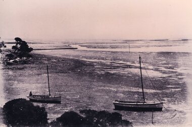
Photograph of two boats, c.1890s
Churchill Island Heritage Farm has a large photograph collection dating from the mid-nineteenth century to the last decade.This series of photographs were taken in the late 1890s and show scenes from around the island while it was owned by Samuel Amess and his family.Black and white reprint of a photograph from the late nineteenth century showing two boats resting on the river floor at low tide. A man sits in the rear of the second boat.Catalogue number written in pencil on reverse. amess house, samuel amess, churchill island, photograph -
 Churchill Island Heritage Farm
Photograph showing two boats resting on the mud, 19th century
Churchill Island Heritage Farm has a large photograph collection dating from the mid-nineteenth century to the last decade.This series of photographs were taken in the late 1890s and show scenes from around the island while it was owned by Samuel Amess and his family.Black and white reprint of a photograph from the late nineteenth century showing two boats resting on the river floor at low tide. A man sits in the rear of the second boat.Catalogue number written on reverse in pencil. Written on reverse in pencil 'Department of Agriculture' Stamp on reverse 'Photograph by Information Branch Victorian Dept. of Agriculture Ref. No 1978(541-26)churchill island, amess house -
Lakes Entrance Regional Historical Society (operating as Lakes Entrance History Centre & Museum)
Photograph, Jack Donelly, 1998 c
Photograph taken from Jemmys PointColour photograph showing discoloured flood water backed up by the incoming tide with fishing boat Crianda shown approaching the Western Pier at the entrance Lakes Entrance Victoriafloods, accommodation -
 Williamstown High School
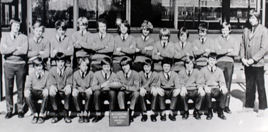
1971 - Junior 1st XVIII
Copy of a black and white photograph mounted on card.On back of photograph: 1971 Junior 1st XVIII - Mr Fogarty. Taken from 1971 High Tide.williamstown high school, 1971, football team -
 Wangaratta RSL Sub Branch
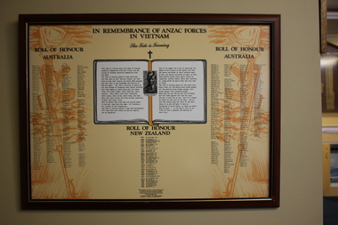
Honour Board - Framed Poster
Honour Roll of ANZAC Forces who served and died during the Vietnam War.Timber framed yellow poster with brown coloured hat and downward facing rifles either side of an open book."In Remembrance of Anzac Forces in Vietnam/The Tide is Turning/Roll of Honour Australia/Roll of Honour New Zealand" vietnam war, anzac forces, honour roll -
Glenelg Shire Council Cultural Collection
Photograph - Photograph - Henty Beach, Aug-89
Port of Portland Authority ArchivesBack: 'Henty Beach area (Yacht club end) August '89 V. High tides' - black biro -
 Williamstown High School
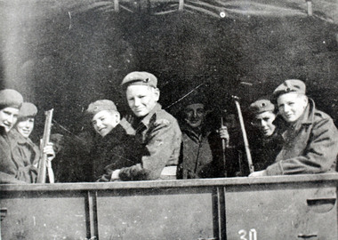
School cadets 1950s
Copy of black and white photograph mounted on board. Accompanied by a caption.Caption reads: Cadets off to camp. On back of photograph: Cadets on camp 1957-8? From High Tide.williamstown high school, cadets, 1957, 1958, 1950s -
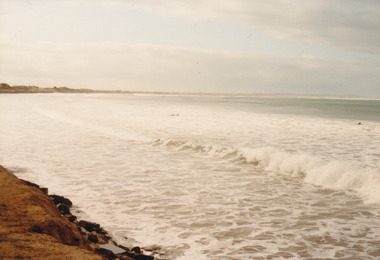 Port Fairy Historical Society Museum and Archives
Photograph
East Beach looking Northeast beach, sea, rough, ocean, dune, tide -
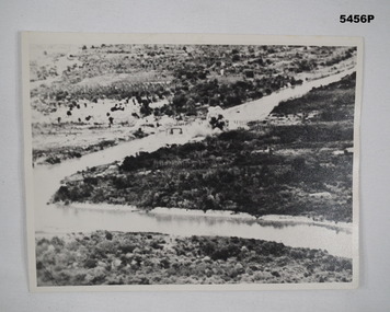 Bendigo Military Museum
Photograph - PHOTOGRAPH, TAMARAN BRIDGE, British Air Force, C1943-1945
Refer Cat no. 5445.2Photo shows flat, uninhibited land. A river (low tide) snakes through the photo. In the centre is a trestle bridge crossing the river. A bomb ( water and smoke) blast is rising from the side of bridge Photograph rear in ink. “Tamaram bridge" being bombed. Bridge built by POWS. The span was never rebuilt. Trains stopping both sides and goods carried along foot of bridge, on a narrow bridge by POWs.ww2, pow, tamaran bridge, burma railway -
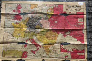 Lara RSL Sub Branch
Newspaper - The Sun Newspaper Dated 5/8/1944 -specia - World War 2 Europe Map and History Of World War 2 and Nazi Tide Flows and Ebbs Across Europe, THe Sun Newspaper Dated 5/8//1944 - Special War Maps
The Sun Newspaper Dated 5/8/1944 Local Newspaper Dated 5/8/1944 - Special World War 2 Maps World War 2 Europe Map and History Of World War 2 and Nazi Tide Flows and Ebbs Across Europeworld war 2 europe map and hisytory of world war 2 and nazi tide flows and ebbs across europe -
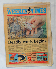 Orbost & District Historical Society
newspaper, The Weekly Times, October 23, 1996
The Weekly Times was first published on September 11, 1869. After absorbing two other rural publications and expanding its publications, in 1902 The Herald and Standard Newspaper Company Ltd became the Herald and weekly Times, now Australia's oldest rural newspaper (more information on Weekly Times website). The article on Orbost was part of a series written by Steve Cooper with photographer, Mark Griffin. It explored communities which were struggling to survive. At that time the timber industry in the area was in decline and there was much discontent about flows to the Snowy River,This newspaper is a useful research tool.A newspaper, titled The Weekly Times, dated October 23, 1996. It contains articles about Orbost - Towns Against The Tide. The paper has an orange cover with the title in blue print and coloured photographs throughout. orbost-history-1996 weekly-times-newspaper -
 Lakes Entrance Regional Historical Society (operating as Lakes Entrance History Centre & Museum)
Postcard, Cooper Alexander, 1910c
Black and white large format postcard of the man made entrance to the Gippsland Lakes, it shows work in progress on the western pier of the entrance, Bullock Island, photo taken at low tide. Lakes Entrance VictoriaLakes Entrance Cunninghameislands, waterways, topography, ships and shipping -
 Lakes Entrance Regional Historical Society (operating as Lakes Entrance History Centre & Museum)
Photograph, 1922
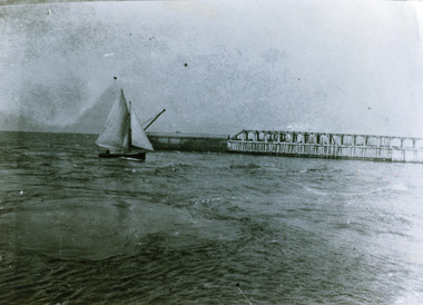
Black and white photograph showing man made entrance from ocean into Gippsland Lakes, wooden Western Pier in background small sailing boat in entrance, whirlpools indicate tide on the turn. Lakes Entrance Victoriaboats and boating, waterways, jetties -
Lakes Entrance Regional Historical Society (operating as Lakes Entrance History Centre & Museum)
Photograph, 1/06/1990 12:00:00 AM
Also one colour photograph taken before unveiling and two taken afterwards 04818.1, .2 and .3 10 x 15 cmColour photograph of the Esso oil rig supply vessel Kurnai Tide at Eastern Wharf prior to the official launch and unveiling of commemorative plaque by dignitaries from government, Esso and Koorie Elders at Lakes Entrance Victorialocal government, politics -
Glenelg Shire Council Cultural Collection
Photograph, 1980
Port of Portland Authority ArchivesBack: 4pm 14/10/80 Tide to 4m View East from near Maretimo Gates Showing Groynes ---Pencilport of portland -
 Williamstown High School
1956 - First day of school
Copy of black and white photograph mounted on board. Accompanied by a caption.Caption reads: First day of school for first form of 1956. On back of photograph: First day of school. High Tide 1956.williamstown high school, 1956, summer uniform -
 Phillip Island and District Historical Society Inc.
Photograph, 1920's
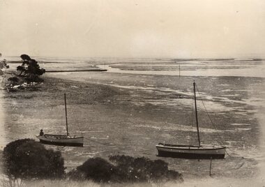
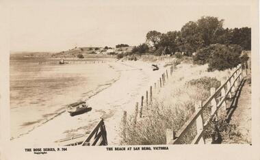
Sent as Happy Birthday wishes from "mother" Feb 18 1923. Part of a collection donated by Edith Elms via Chrisy Northcote.Sepia print of San Remo coastline at low tide with dinghy at left foreground. Two fences traversing from bottom to 3/4 where trees merge, sailboat beached at centre. Pier at 3/4 left top.The Rose Series, P764. The beach at San Remo - Victorialocal history, photography, photographs, san remo, coastline, sepia photograph, coastal views -
Port Melbourne Historical & Preservation Society
Plan - Setting temporary gangway at Inner East berth Station Pier for Tasmanian ferry Abel Tasman, Engineering Division, Port of Melbourne Authority, 1984
Plan: cross section at passenger doors showing deck levels - ship empty highest allowable tide (Drawing used in the setting up of temporary gangway at the Inner East berth of Station Pier for the vessel Abel Tasman) 1984melbourne harbor trust - port of melbourne authority, piers and wharves - station pier, abel tasman -
Port Melbourne Historical & Preservation Society
Plan - Setting temporary gangway at Inner East berth Station Pier for Tasmanian ferry Abel Tasman, Engineering Division, Port of Melbourne Authority, 1984
Plan: cross section at passenger doors showing deck levels - ship full lowest allowable tide (Drawing used in the setting up of temporary gangway at the Inner East berth of Station Pier for the vessel Abel Tasman), 1984melbourne harbor trust - port of melbourne authority, piers and wharves - station pier, abel tasman -
 Lakes Entrance Regional Historical Society (operating as Lakes Entrance History Centre & Museum)
Photograph, Holding M, 2000
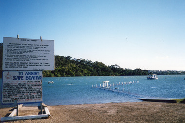
Date made January 2000Colour photograph of high tide in the North Arm. It shows the boat ramp and jetty under water, boat moored in lake, pelican fishing nearby. Warning and instruction signs on shore. Kalimna Heights in background. Lakes Entrance Victoriaboats and boating, vegetation, waterways, topography -
 Lakes Entrance Regional Historical Society (operating as Lakes Entrance History Centre & Museum)
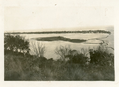
Photograph, 1930c
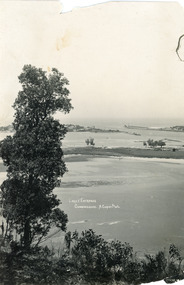
Black and white photograph of Bullock Island, showing the footbridge to the island, the rock groynes at the western end of the island, built to direct flood and tide waters to entrance. Photo taken from Kalimna Hill, scub in foreground. Lakes Entrance Victoriawaterways, islands, township -
 Lakes Entrance Regional Historical Society (operating as Lakes Entrance History Centre & Museum)
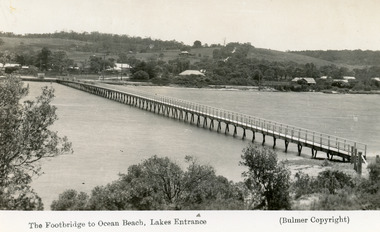
Postcard - Footbridge, 1937c
Copies as follows|One Miniture postcard tinted 6.5 x 9|One Black and white copy 6.5 x 11|One Tinted copy 20 x 28|One Postcard 17 x 12Black and white postcard showing waterfront, some buildings along esplanade, no buildings on Myer St Hill. Footbridge across Cunninghame Arm completed to high tide mark, ramp constructed later, scrub in foreground. Lakes Entrance VictoriaThe Footbridge to Ocean Beach Lakes Entrancevegetation, bridges, waterways, township -
 Churchill Island Heritage Farm
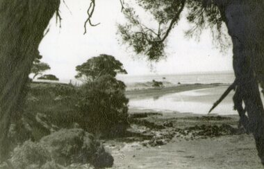
Photograph - Black and white landscape photograph of cove, c.1939
Churchill Island Heritage Farm has a large photograph collection dating from the mid-nineteenth century to the last decadeBlack and white landscape photograph of a cove taken from the shelter of trees.Catalogue number written in pencil on reverse. On reverse in pen '1939 Tide out from below the big dam looking towards north point'churchill island -
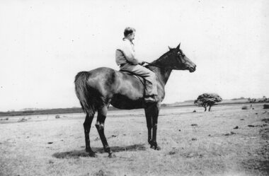 Churchill Island Heritage Farm
Photograph - Photograph of man on horse, c.1940
Churchill Island has a large photograph collection dating from the nineteenth century. This series consists of candid photographs of everyday life taken by previous residents of the island.Black and White photograph of a man sitting on a horse on a large pasture.Catalogue number written on reverse in pencil. Handwritten in pen on reverse: '1940. SELF. LOOKING TOWARDS MANGROVE AREA. NOTE TIDE - WELL OUT'churchill island