Showing 174 items
matching tourism maps
-
 Kew Historical Society Inc
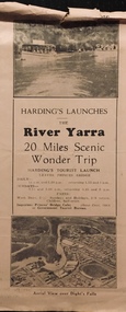
Flyer, Melbourne Ferries Pty Ltd, River Yarra: 20 Miles Scenic Wonder Trip
Bifold brochure including route map of the full 44 mile 'Wonder Trip' on pages 2 & 3. Photos used include an 'Aerial view over Dight's Falls', two ferries, and a 'Scene near Dight's Falls'.Flyer for Harding’s Launches on the River Yarra: 20 miles scenic wonder trip. Aerial view over Dight’s Falls on front. non-fictionBifold brochure including route map of the full 44 mile 'Wonder Trip' on pages 2 & 3. Photos used include an 'Aerial view over Dight's Falls', two ferries, and a 'Scene near Dight's Falls'.river yarra, melbourne ferries pty ltd, yarra river -- tourism, harding's cruises, christian-washfold collection -
 Clunes Museum
Flyer - BROCHURE
... information for tourists visiting Clunes Map of Clunes Tourism ...Current information for tourists visiting ClunesColour brochure of Clunes Museum with map of Clunes on the reverseClunes Museum - Built on Goldmap of clunes, tourism brochure, clunes museum -
 Stawell Historical Society Inc
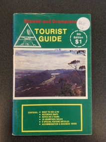
Book, Stawell & Grampians Tourist Council, Stawell & Grampians Visitor Guide & Directory 1979, 1979
Tourist Guide to Stawell and the GrampiansBlue cover with red, yellow & blue print. Picture of the Grampians in center of cover.In Red Print Stawell and Grampians. In Yellow Print Visitor Guide and Directory. In Blue Print 4th Edition Souvenir Edition. In White Inset "Containing Offical Walking Maps. Bottom Right in Yellow Print " Issued by the Stawell and Grampians Tourist and Promotion Advisory Council. In two white circle with white and Red print the Price in Red "Recommended $1.00 Price" Bottom Right at 45 degrees in blue print Concession Coupons Inside.stawell tourism -
 Stawell Historical Society Inc
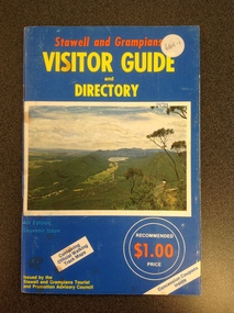
Book, Stawell & Grampians Tourist Council, Stawell & Grampians Visitor Guide & Directory 1981, 1981
Tourist Guide to Stawell and The GrampiansGreen paper cover with Red, Yellow & White Print. Centre of page is a colour photo of the Grampians. Red Test. "Stawell and Grampians" inside white triangle "Stawell & Grampians Promotion". Yellow Print Tourist Guide" Inside a white segmented circle, white Print "5th Editon $1" Inside Yellow outlined rectangle with yellow Print. "Contains: WHAT TO SEE & DO REFERENCE MAPS NOTES ON 5 TOURS 28 GRAMPIANS WALKS 9 SPECIAL FEATURE ATICLES ACOMMODATION & BUSINESS GUIDEstawell tourism -
Stawell Historical Society Inc
Map, Tourist Map of Grampians/Halls Gap and Surrounds, 1928
... grampians Stawell Tourism Tourist Map of Grampians/Halls Gap ...Tourist Map of Grampians/Halls Gap and Surroundsstawell, tourism -
 City of Greater Bendigo - Civic Collection
Map - Rosalind Park and surrounds
city of greater bendigo tourism, rosalind park, faith leech memorial swimming pool, city of greater bendigo events -
 City of Greater Bendigo - Civic Collection
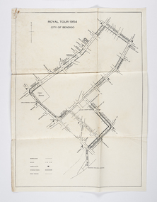
Document - Set of correspondence re Queen Elizabeth tour of Bendigo, Mrs T. R. Mannix, February 8th, 1954
Correspondence between Mrs T. R. Mannix, Swan Hill Wolf Cub Pack master to District Scout Commissioner Mr J. I. Samson for an invitation to be included with the local scout groups in functions to welcome Queen Elizabeth and the Duke of Edinburgh to Bendigo on Friday, the 5th of March 1954. The response from the Commissioner included typed plans of the event and maps of the royal tour through the streets of Bendigo starting and finishing at the train station.Set of correspondence including typed gatefold letter, typed plans for placement of visitors and role of the military and maps of CBD Bendigo and of Upper Reserve.queen elizabeth, duke of edinburgh, boy scout association, mayor clayton, city of greater bendigo royal visits, city of greater bendigo community groups, city of greater bendigo tourism -
 City of Greater Bendigo - Civic Collection
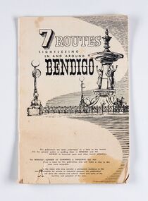
Booklet, J. W. H Publications, 7 Routes. Sightseeing in and around Bendigo, c 1950
A publication promoting visitation and automobile touring around Bendigo and surrounding districts. Suggests seven routes and contains extensive advertising for accommodation, businesses and services within Bendigo and Castlemaine.Thirty two page tourist fold out booklet containing maps and directions for half day and day routes in the district. Booklet also contains advertising promoting Bendigo and District businesses. city of greater bendigo commerce, city of greater bendigo tourism, making a nation exhibition -
 City of Greater Bendigo - Civic Collection
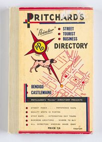
Book - Street Directory, A. E. Pritchard, Pritchards 'Pointer' Street - Tourist - Business - Directory, 1953
As tourism and car culture grew in the early and mid 20th century the need for street and touring directories grew. Bendigo's geographic location within central Victoria and relatively closeness to Melbourne meant that the district has long been an ideal car touring destination. A. E. Pritchard was a licensed surveyor with an office in Bull Street Bendigo and produced these handy bound directories which fit neatly into the car glovebox therefor serving both the local and state demand for high quality printed directories such as these. One hundred and thirty page printed and bound street and touring directory. Includes fold out reference and day touring maps, photographs of local 'beauty' spots and extensive advertising by local businesses. Heavy card used for front and back covers. Three colour print process.Pritchards 'Pointer' Directory Bendigo - Castlemaine.city of greater bendigo commerce, city of greater bendigo tourism, city of greater bendigo leisure, making a nation exhibition, cambridge press, mayor w cambridge -
 City of Greater Bendigo - Civic Collection
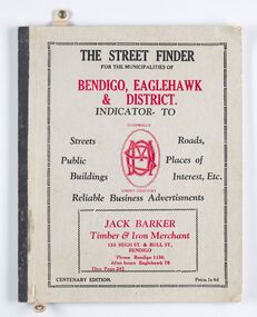
Book - Street Directory, McConnell Publisher, The Street Finder
General district street, business and services directory aimed less at the tourist market and more at the Bendigo and Eaglehawk population. Includes advertising. Index is extensive and includes services such as child care centres, cemeteries, theatres and schools.Thirty two page, printed and bound street and business directory for Bendigo, Eaglehawk and district. Grey card front cover with grey cardboard back cover. Printed in red and black ink. Includes Index for trades, streets and services such as banks, baths, sporting clubs and police stations. Majority of content is text and advertising and the only map included in the publication is printed inside the back cover.The Street Finder / for the municipalities of / Bendigo, Eaglehawk / & District. city of greater bendigo commerce, city of greater bendigo community groups, city of greater bendigo tourism, borough of eaglehawk, making a nation exhibition -
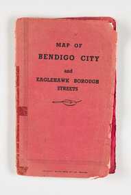 City of Greater Bendigo - Civic Collection
Map, Bolton Brothers Printers, Map of Bendigo City and Eaglehawk Borough Streets, Unknown
... Tourism Fold out map with a book style red and black printed front ...Produced by local company Bolton Brothers. Suitable for the glove box of car.Fold out map with a book style red and black printed front and back cover. Includes a three page index of street names and reference points. city of greater bendigo commerce, city of greater bendigo tourism -
 Tarnagulla History Archive
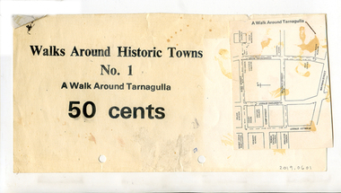
Clippings: Tarnagulla Historic Walk, circa 1960s-1980s
Donald Clark Collection.Three paper clippings, stapled together. One has printed text "Walks Around Historic Towns No.1 A Walk Around Tarnagulla 50 Cents". The other two are a photo of the Tarnagulla Wesleyan Church and a map of Tarnagulla marked with highlights.tourism -
 Tarnagulla History Archive
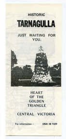
Brochure: Historic Tarnagulla, circa 1990s
Donald Clark Collection.Foldable photocopied brochure with title 'Historic Tarnagulla, Just Waiting For You'. Contains a map of the region marked with day trip places of interest. Also has a list of 'Things to Do and See' and a list of local traders in Tarnagulla.tourism, local history, walking tours -
 Tarnagulla History Archive
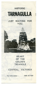
Brochure: Historic Tarnagulla, circa 1990s
Donald Clark Collection.Foldable photocopied brochure with title 'Historic Tarnagulla, Just Waiting For You'. Contains a map of the region marked with day trip places of interest. Also has a list of 'Things to Do and See' and a list of local traders in Tarnagulla.tourism, local history, walking tours -
 Wodonga & District Historical Society Inc
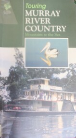
Book - Touring Murray River Country, Stone, Derrick I & Stone, Sascha C, 1996
A touring guide of the Murray RIver, Australia from its source in the mountains following its journey to the sea. The first sections cover information about the area of the Upper Murray, including Lake Hume and the Albury-Wodonga area.A publication of 128 pages includes 230 full colour photos, 42 illustrations and 19 colour route maps. A touring guide of the Murray RIver, Australia from its source in the mountains following its journey to the sea. The first sections cover information about the area of the Upper Murray, including Lake Hume and the Albury-Wodonga area.murray river, australia - tourism -
 Falls Creek Historical Society
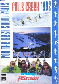
Magazine - Falls Creek 1992 For The Best Snow Falls
A part of a yearly marketing magazine program promoting Falls Creek ski region for the winter holidays. It includes 28 pages of comprehensive information and maps describing resort facilities, different runs and access to the snow. Available accommodation is explained with the inclusion of tariffs for 25 different venues in both lodges and apartments for 1992. Transport, ski hire, other village services and insurance and booking agents are also explained. This issue was published for the Falls Creek Chamber of Commerce and supported by the Victorian Tourism Commission.This item is important as it documents seasonal activities at Falls Creek Alpine ResortMagazine titled "Falls Creek 1992 For The Best Snow Falls". It is a comprehensive guide to activities, accommodation and services in Falls Creek.falls creek marketing, accommodation falls creek, facilities falls creek, falls creek chamber of commerce -
 Falls Creek Historical Society
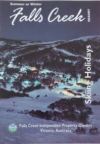
Booklet - Falls Creek Skiing Holidays 1993
Part of a yearly marketing and information material promoting Falls Creek Region. It includes accommodation rates and travel information which features a map of Falls Creek Village. Venues included in the chart are:- Astra Lodge, Diana Lodge, Karelia Lodge, Snowdrift Lodge, Snowhaven, Viking Lodge, Alpine View Apartments, Cumings Holiday Apartments and Koki Apartments.This item is important as it documents seasonal activities and accommodation venues and rates at Falls Creek Village in the 1990s. An A4 size leaflet promoting Falls Creek of the ski season of 1993. An accommodation rates chart is included in the centre page.accommodation falls creek, falls creek marketing, falls creek tourism, skiing holidays victoria -
 Falls Creek Historical Society
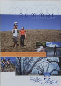
Booklet - Falls Creek Summer in the High Country 2002 - 2003
A part of a yearly marketing and information program to promote activities in the Falls Creek area outside of the winter season. This booklet promotes a wide range of activities and venues in Falls Creek and surrounding district.This item is important as it documents seasonal activities at Falls Creek Alpine area and how they have been promoted. An A4 sized marketing booklet, including images, maps and advertising information printed on glossy paper.falls creek tourism, falls creek victoria, falls creek summer -
 Falls Creek Historical Society
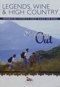
Booklet - Legends, Wine & High Country - Stepping Out
This is one of several booklets published to promote tourism throughout Victoria. It contains detailed information to promote tourism in the region of Northeast Victoria. It was published by the Victorian Tourism Information Service in April 1999.This item is important as it documents how the region of Northeast Victoria has been promoted by the Victorian government. An A4 sized marketing booklet, including images, maps and detailed information about walks, trails and activities in .Northeast Victoria published by the Victorian Tourism Information Board'tourism victoria, falls creek tourism, legends wine and high country, victorian tourism information service -
 Warrnambool and District Historical Society Inc.
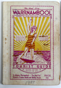
Booklet - Warrnambool Tourist Guide, Warrnambool Progress Association, Warrnambool On The Sea Tourist Guide, The Ideal City, Where to Go and What to See, 1936
Warrnambool Tourist Guide 1936This is a booklet with a buff-coloured cover featuring an illustration of a woman water skiing. The back cover has blue printing. The pages contain a fold-out map, advertisements, printed text and black and white photographs. The pages have been stapled and then glued.non-fictionWarrnambool Tourist Guide 1936tourism in warrnambool, warrnambool progress association -
 Warrnambool and District Historical Society Inc.
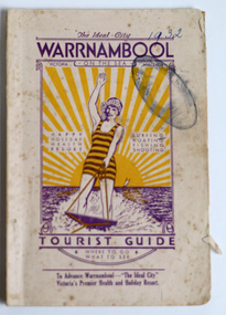
Booklet - Warrnambool Tourist Booklet, Warrnambool Progress Association, Warrnambool On the Sea, Victoria, Australia, Tourist Guide, 1932
Warrnambool Tourist GuideThis is a booklet with a cream cover featuring a sketch of a woman waterskiing and blue printing. The pages contain black and white photographs, advertisements, two maps and printed text. There is one fold-out page. The booklet is stapled and bound with glue.non-fictionWarrnambool Tourist Guidewarrnambool tourism, warrnambool progress association -
Clunes Museum
Pamphlet, BUSINESS & TOURISM, BURIED RIVERS OF GOLD, 2021
MAP OF DEEP LEAD MINES, CRESWICK. WALKING TOURCOLOURED PAMPHLET FOLDED TO DL SIZE. INCLUDES MAP AND INFORMATION FOR SELF GUIDED TOUR. MAP OF THE DEEP LEAD MINES, CRESWICK, AND NOTES FOR YOUR SELF-GUIDED TOUR.gold mining, creswick -
 Bendigo Historical Society Inc.
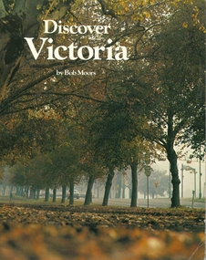
Book - DISCOVER VICTORIA, 1979
Discover Victoria by Bob Moors, soft cover 104 pages with maps, black and white & colour illustrations, published by Decalon Pty Ltd Melbourne. This book, with the compliments of The Department of State Development, Decentralization and Tourism is designed to introduce you to the many tourist attractions in the twelve regions of Victoria, the garden state.victoria, history, people and places in victoria. -
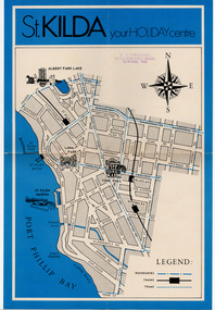 St Kilda Historical Society
Document - Map, St Kilda your holiday centre, c1970
... been produced in 1970. St Kilda tourism Single sheet map ...Map of St Kilda for tourists. Undated but estimated to have been produced in 1970.Single sheet map printed on paper in blue and blackst kilda tourism -
 Warrnambool and District Historical Society Inc.
Booklet - Warrnambool Visitor's Handbooks 1979-2024, Collett, Bain and Gaspar, Printers, 1979-2014
This is a collection of eight Warrnambool Visitor handbooks produced between 1979 and 2014 by the City of Warrnambool Tourist Information Centre. They contain maps of Warrnambool, lists of services, accommodation and tourist attractions as well as many advertisements for local businesses.These handbooks give a useful snapshot of businesses and tourist attractions in Warrnambool for each of the years covered. (1979, 1980, 1986, 1990, 1993, 1994, 1995, 2014)[.1a] A 48 page booklet with white pages and blue printing. The front cover has a coloured photograph of Flagstaff Hill with boats on a man made lake in the foreground looking across Lake Pertobe toward South Warrnambool. [.1b] A coloured bifold brochure. The front cover has a fisherman on a cray-boat holding a crayfish in the lower section. The top quarter has a blue back ground with white printing. The rear cover is red and has small photos of the Hopkins River and the Framlingham Forest. [.2] A 48 page booklet with white pages and black printing. The front cover is white with black writing on the left hand side and a colour photograph of the Loch Ard peacock. The Warrnambool Premier Town stylised logo of seven Norfollk pines above blue waves is in the top right hand corner. There is a blank ink Warrnambool Library stamp underneath the logo. The rear cover has photographs of The Twelve Apostles and the Hopkins Falls and the Premier Town Logo [.3] A 40 page booklet with mainly black printing on white paper. There are three fold out maps of Warrnambool and the surrounding district. The glossy cover has a black background with a colour photograph of the Twelve Apostles taken at sunset. The rear cover has three small of Proudfoot's boathouse on the Hopkins River, Flagstaff Hill, and the main beach area. The front cover has black writing inside to peach coloured rectangles. The inside rear cover has a fold out coloured tour map of Western Victoria. [.4] A 40 page booklet printed on glossy white paper with coloured photographs and black and red printing. The front cover has a photograph of The Twelve Apostles surrounded by a white border. There is red writing in the upper border. There is a sandy coloured writing superimposed across the bottom of the photograph and a Victoria's Shipwreck Coast logo in the bottom right hand corner. [.5] A 44 page booklet printed on white paper with black printing. The cream coloured cover has a pale red rectangle with blue writing on the right hand facing edge and includes two stylised Norfolk pines and with waves underneath. There is is an intersecting blue rectangle with cream printing. [.6] A 48 page booklet printed on white paper with black printing. The cover is brown with a cream vertical strip containing black writing on the right hand side. There is a stylised map from Geelong to Mount Gambier showing the Great Ocean Road across the cover. [.7] A 48 page booklet printed on white paper with black print. The glossy colour cover has a photograph of a Southern Right whale fluke. There is white printing on a the blue background of the sky and sea. The bottom left hand side of the front cover has a Tourism Victoria logo made of jigsaw puzzle pieces. The back cover has a stylised coloured map of The Great Ocean Road located in a white rectangle at the top of the page. Within the rectangle is a small map of Australia locating Victoria and the part of Victoria covered by the map. [.8] A 64 page A5 coloured booklet printed on white pages with black print. The white front cover has black and grey print with a colour photograph of two people holding coffee cups watching four race horses being exercised on the beach and in the water of Lady Bay in the early morning. The bottom right hand corner has a Tourism Victoria logo. The rear cover has a mainly blue back ground with a pink orange and green colour splats contains words advertising the 2015 Fun 4 Kids Festival [.1a] Warrnambool The Heart of Victoria's Great Southwest Visitor's Handbook [.1b] Warrnambool City for all seasons; The Heart of Victoria's Great Southwest [.2] Warrnambool visitor's handbook Warrnambool Premier Town 1979-1982 [.3] Warrnambool Handbook Victoria [.4] Warrnambool The Shipwreck Coast [.5] Welcome to Warrnambool Warrnambool Visitors Handbook 1993-1994 [.6] Welcome to Warrnambool Visitors Handbook 1994-95 Rear cover: Warrnambool Centre of Victoria's Shipwreck Coast on Australia's Great Ocean Road [.7] Warrnambool Shipwreck Coast - Great Ocean Road; You'll love every piece of Victoria; Visitors Handbook [.8] Warrnambool Great Ocean Road Official Visitor Guide; It's a wonderful Warrnambool; You'll love every piece of Victoria visitvictoria.com. Rear Cover Live entertainment.Workshops.Creativity.Action 28 June - 5 July 2015 Australia's Best Children's Festival F4K The ultimate winter school holiday adventure Fun 4 kids festival Warrnambool For more information visit Fun4kids.com.au Warrnambool great Ocean Road Victoriawarrnambool, visitor handbooks, tourist information guides, warrnambool maps -
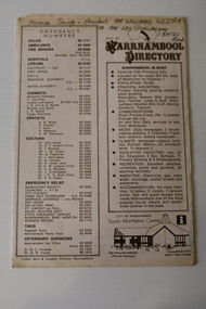 Warrnambool and District Historical Society Inc.
Pamphlet - Warrnambool Directories, Warrnambool City Council (Warrnambool Tourist Information Centre), Warrnambool Directory. Welcome to Warrnambool, Warrnambool and District Directory, 1970s and 80s
Warrnambool Directories.1 and .2 One sheet of paper folded twice to provide six pages. The pages contain a map and printed material. .3 One sheet pf paper folded to provide sixteen pages. The pages contain two maps and printed material. The front page has a stamp indicating the original owner. non-fictionWarrnambool Directorieswarrnambool tourism, shipwreck coast tourism -
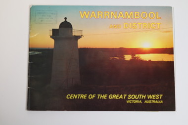 Warrnambool and District Historical Society Inc.
Booklet - Tourist Booklet, Warrnambool Chamber of Commerce and Industry, Warrnambool and District - Centre of the Great South West, Victoria, Australia, c. 1970
Warrnambool Tourist BookletThis is a booklet of 22 pages. The cover has two colour photographs and the pages contain a sketch map, printed text and colour photographs. The pages have ben stapled but the staples have been removed.non-fictionWarrnambool Tourist Bookletwarrnambool tourism, south west victoria tourist locations, warrnambool chamber of commerce -
Lakes Entrance Historical Society
Book, Jones Rebecca, An Ideal Excursion: A Recreation History of the Gippsland Lakes and its Guesthouses, 1880-1930, 1994
A history of guest houses and recreational pursuits of person holidaying in the gippsland lakes hinterland written as a thesis for a student during a master of arts degree sketch maps are used for location purposes photographs (photocopy) illustrations.guesthouses, settlers, tourism -
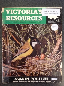 Stawell Historical Society Inc
Book, Natural Resources Conservation, Victoria's Resources - Vol 3 No 4, 1962
Departments, Regions, Municipalities and Organisations which are members of the Conservation League. These books were provided free of charge to residents.Paper cover: 3/4 Green strip with white & black print. Black section containing map of Victoria below a colour picture of a nesting mother bird with chicks below black strip with white printVictori's Resources Vol 3. No. 4. December 1961 February 1962. Published Quarterly Price 1'6 Golden Whistler Beautiful Insectivorous bird widespread thoughout Australiatourism -
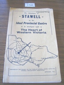 Stawell Historical Society Inc
Book, Council of the Town of Stawell, The Advantages of Stawell as the Ideal Provincial Centre, 1966
Tan card cover with black border inside of which is a map of VictoriaThe Advantages of Stawell as the Ideal Provincial Centre to be developed right in the heart of Western Victoria. Prepared by the Council of the Town of Stawell Jointly with the Stawell Development Association September1966stawell tourism