Showing 1046 items
matching trails
-
 Eltham District Historical Society Inc
Photograph, Diamond Creek floodwater, Eltham
Four colour photographs of Diamond Creek floods in Susan Street and Dalton Street area. 1. Floodwater of Diamond Creek spreading towards Susan Street over the oval 2. Floodwater of Diamond Creek spreading towards Susan Street over the oval 3. Diamond Creek Trail from Dalton Street 4. Diamond Creek Trail from Dalton Streetdiamond creek, floods, etham, dalton street, susan street -
 Bendigo Historical Society Inc.
Photograph - CASTLEMAINE GAS COMPANY COLLECTION: PHOTO BENDIGO, 23/08/1996
Bendigo plough trail 23/08/1996. A person looking at the track being dug by plough. Another one near ute and several more standing.Fujiorganisation, industry, gas and fuel -
 Whitehorse Historical Society Inc.
Photograph - Coloured photograph, Quarry Road Mitcham
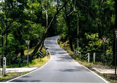
Coloured photograph of Quarry Road, Mitcham looking south. A bridge over Mullum Mullum Creek and the Eastlink Trail appear on the lower section of the photograph - 2012quarry road, mitcham. east link trail -
 Kiewa Valley Historical Society
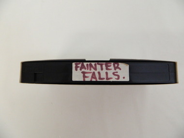
Video - Fainter Falls, Fainter Falls, 2003 - 2008
Visual workings and development of the Fainter Falls Trail completed in 2008. The trail was originally accessible via a fire fighting access trail. The fire in the summer of 2003 highlighted the beauty of the area and provided the residents of the Kiewa Valley with the opportunity to consider the redevelopment of the trail. Work to establish a 700 metre grade 2 walking trail with a 50 metre grade 3 extension trail to the Falls began in 2005. It also includes 3 observation decks, a bridge over a creek crossing, car parking and interpretive signage.This video recording is a visual recording of the process of the establishment of the Fainter Falls Walking Trail giving an insight into the process, the work, tools and materials used for such work from 2003 to 2008. It also shows the vegetation in the area and the amount of water flowing at the time.White cardboard cover with black plastic video labelled "Fainter Falls" on outer edge."Fainter Falls"fainter falls. bogong. walking trail. fire track. national parks of victoria -
 Falls Creek Historical Society
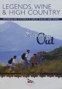
Booklet - Legends, Wine & High Country - Stepping Out
This is one of several booklets published to promote tourism throughout Victoria. It contains detailed information to promote tourism in the region of Northeast Victoria. It was published by the Victorian Tourism Information Service in April 1999.This item is important as it documents how the region of Northeast Victoria has been promoted by the Victorian government. An A4 sized marketing booklet, including images, maps and detailed information about walks, trails and activities in .Northeast Victoria published by the Victorian Tourism Information Board'tourism victoria, falls creek tourism, legends wine and high country, victorian tourism information service -
 Tatura Irrigation & Wartime Camps Museum
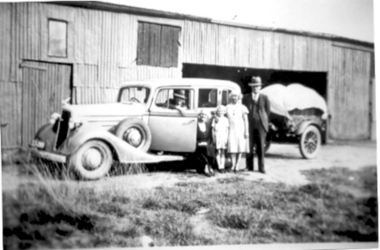
Photograph, Hogan Family
L-R: George and Lucy Dick, Lucy Ranson (nee Hogan), Jean and John Hogan.|Family posing in front of loaded up trailor and car before a departure.tatura, john hogan family, costume, children, female, male, transport, motor, vehicles -
 Wangaratta High School
WSC Yearbook -Geronimo, 1998
Black yearbook with a full-page image of a girl surrounded by circular fire trails. Coloured writing advertises the contents of the issue and the heading reads Geronimo '98 THE YEAR IN REVIEWGeronimo '98 THE YEAR IN REVIEW INSIDE: Check out our FULL COLOUR centrefold! Artwork Writing Photography The School gets a makeover SPORTS UPDATE Wangaratta Secondary College, The end of an Era A special report from principal, Mr Pech -
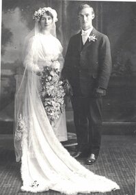 Linton and District Historical Society Inc
Photograph, Harold Morgan and Myrtle Cornish, 1917
Black and white copy of original photograph of a bride and groom. The bride is wearing a white dress with a train spread out in front of her. She is holding large trailing bouquet."Harold Robert Morgan + Bride (nee) Myrtle Alma Yeoman Cornish 1917"harold robert morgan, myrtle alma yeoman morgan (nee cornish), wedding -
 Lakes Entrance Historical Society
Book, Ryan, Bonnie, Draft Recreation Plan December 2000 and September 2001, 2000
Also recreation plan September 2001 VTMH526.1Draft Recreation Plan Dec.2000,providing a recreational link track from the Bairnsdale to Orbost Rail Trail through the Colquhoun Forest and North Arm to Lakes Entrance.recreation facilities, planning committee -
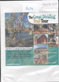 Bendigo Historical Society Inc.
Document - THE GREAT DIVIDING TRAIL TOUR
DVD. The trail consists of four linked tracks stretching from Bacchaus Marsh to Bendigo, each of which in turn consists of easily accessible, one day or shorter walks. -
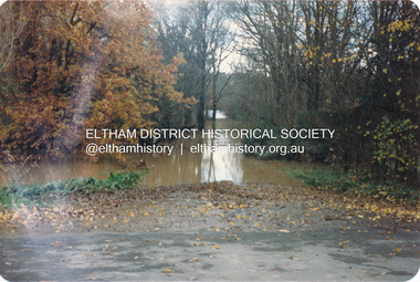
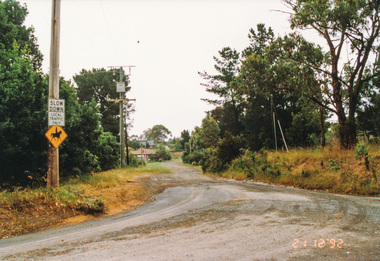
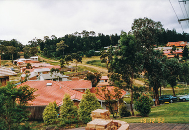
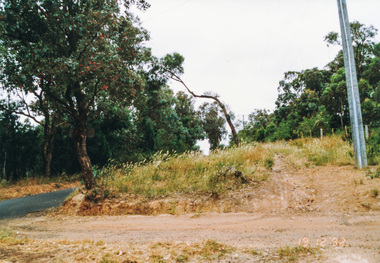 Eltham District Historical Society Inc
Photograph, Ingrams Road, south from Allendale Road, Research, 19 December 1992, 19/12/1992
The Eltham Horse Trail: Research and Warrandyte to Kinglake: Survey of proposed route, December 1992: (4) Connecting trail to ElthamColour photographeltham horse trail (1992 survey), allendale road, ingrams road, research (vic.) -
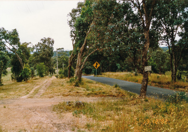 Eltham District Historical Society Inc
Photograph, Ingrams Road looking north to Allendale Road, Research, 19 December 1992, 19/12/1992
The Eltham Horse Trail: Research and Warrandyte to Kinglake: Survey of proposed route, December 1992: (4) Connecting trail to ElthamColour photographeltham horse trail (1992 survey), allendale road, ingrams road, research (vic.) -
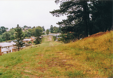
 Eltham District Historical Society Inc
Photograph, Margaret Street from Ingrams Road, Research, 21 December 1992, 21/12/1992
The Eltham Horse Trail: Research and Warrandyte to Kinglake: Survey of proposed route, December 1992: (4) Connecting trail to ElthamColour photographeltham horse trail (1992 survey), ingrams road, research (vic.), margaret street -
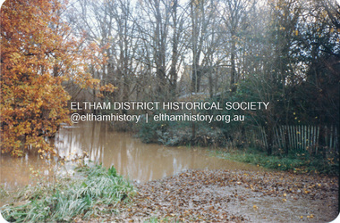
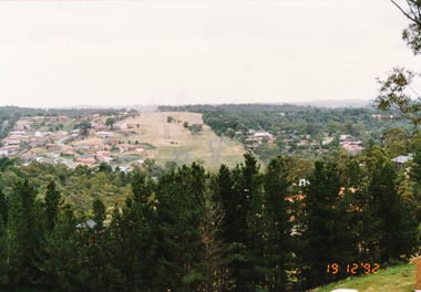 Eltham District Historical Society Inc
Photograph, Power line easement between Eltham and Research viewed from Afton Street, Research, 19 December 1992, 19/12/1992
The Eltham Horse Trail: Research and Warrandyte to Kinglake: Survey of proposed route, December 1992: (4) Connecting trail to ElthamColour photographeltham horse trail (1992 survey), afton street, eltham, research (vic.), transmission lines -
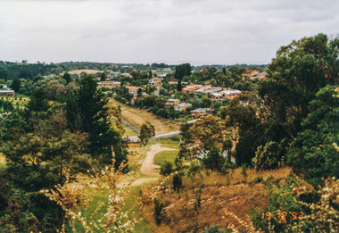 Eltham District Historical Society Inc
Photograph, Metropolitan Water pipe track east from Afton Street, Research, 19 December 1992, 19/12/1992
The Eltham Horse Trail: Research and Warrandyte to Kinglake: Survey of proposed route, December 1992: (4) Connecting trail to ElthamColour photographeltham horse trail (1992 survey), afton street, research (vic.) -
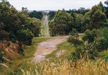 Eltham District Historical Society Inc
Photograph, Metropolitan Water pipe track west from Afton Street, Research, 19 December 1992, 19/12/1992
The Eltham Horse Trail: Research and Warrandyte to Kinglake: Survey of proposed route, December 1992: (4) Connecting trail to ElthamColour photographeltham horse trail (1992 survey), afton street, research (vic.) -
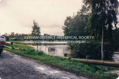
 Eltham District Historical Society Inc
Photograph, Metropolitan Water pipe track west from Maroong Drive, Research, 19 December 1992, 19/12/1992
The Eltham Horse Trail: Research and Warrandyte to Kinglake: Survey of proposed route, December 1992: (4) Connecting trail to ElthamColour photographeltham horse trail (1992 survey), research (vic.), maroong drive -
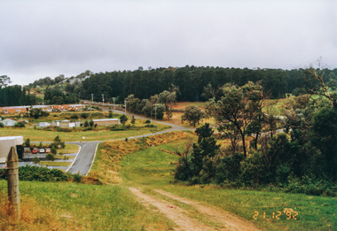
 Eltham District Historical Society Inc
Photograph, Metropolitan Water pipe track looking west near The Esplanade, Research, 21 December 1992, 21/12/1992
The Eltham Horse Trail: Research and Warrandyte to Kinglake: Survey of proposed route, December 1992: (4) Connecting trail to ElthamColour photographeltham horse trail (1992 survey), research (vic.), the esplanade -
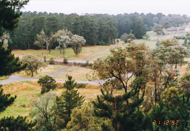
 Eltham District Historical Society Inc
Photograph, Metropolitan Water pipe track looking east near The Esplanade, Research, 21 December 1992, 21/12/1992
The Eltham Horse Trail: Research and Warrandyte to Kinglake: Survey of proposed route, December 1992: (4) Connecting trail to ElthamColour photographeltham horse trail (1992 survey), research (vic.), the esplanade -
 Eltham District Historical Society Inc
Photograph, Metropolitan Water pipe track south of Main Road from near The Esplanade, Research, 21 December 1992, 21/12/1992
The Eltham Horse Trail: Research and Warrandyte to Kinglake: Survey of proposed route, December 1992: (4) Connecting trail to ElthamColour photographeltham horse trail (1992 survey), research (vic.), the esplanade, main road -
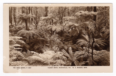 Marysville & District Historical Society
Postcard (item) - Black and white postcard, Rose Stereograph Company, Talbot Drive, Marysville, Vic. No. 2, Michael Dene, 1913-1967
A postcard in a series produced by the Rose Stereograph Company in Victoria, Australia as a souvenir of Marysville.A black and white photograph showing trees and tree ferns, taken along the Michaeldene Trail near Lady Talbot Drive in Marysville in Victoria. The Michaeldene Trail is a level two loop that leads to the Taggerty River Lookout and may be undertaken as either as a Short (2.7 km) Loop, or a Long (4.3 km) Loop - 30 minutes to one hour and a half. The attractive bushland linking the Steavenson and Taggerty Rivers allows walkers and cyclists to step back in time to Marysville’s historic logging past. Sections of this mostly flat circuit follow old tramline alignments, which in places reveal the original timber sleepers on which the big logs were transported to the nearby sawmill.The Taggerty River Lookout offers views over the Taggerty River. The Trestle Bridge was built to span a small gully and provide access to the timber on Red Hill. Lady Talbot Drive is a 24 kilometer scenic rainforest car journey which passes a number of walks and waterfalls in the Yarra Ranges National Park. Lady Talbot Drive is named after Lady Sarah Elizabeth, the wife of Sir Reginald Talbot, who was the Governor of Victoria from 25th April, 1904 to 6th July 1908. This postcard was produced by the Rose Stereograph Company as a souvenir of Marysville.REAL PHOTO POST CARD THE "ROSE"SERIES DE LUXE PRODUCED IN AUSTRALIA Published by "The Rose Stereographs" Armadale, Victoria.marysville, victoria, michael dene, michael dene track, p. 2307, walking track, rose series postcard, postcard, souvenir, lady talbot drive, sarah elizabeth talbot, sir reginald talbot -
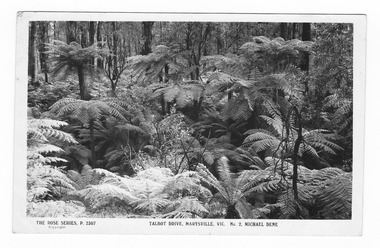 Marysville & District Historical Society
Postcard (item) - Black and white postcard, Rose Stereograph Company, Talbot Drive, Marysville, Vic. No. 2, Michael Dene, 1913-1967
A postcard in a series produced by the Rose Stereograph Company in Victoria, Australia as a souvenir of Marysville.A black and white photograph showing trees and tree ferns, taken along the Michaeldene Trail near Lady Talbot Drive in Marysville in Victoria. The Michaeldene Trail is a level two loop that leads to the Taggerty River Lookout and may be undertaken as either as a Short (2.7 km) Loop, or a Long (4.3 km) Loop - 30 minutes to one hour and a half. The attractive bushland linking the Steavenson and Taggerty Rivers allows walkers and cyclists to step back in time to Marysville’s historic logging past. Sections of this mostly flat circuit follow old tramline alignments, which in places reveal the original timber sleepers on which the big logs were transported to the nearby sawmill.The Taggerty River Lookout offers views over the Taggerty River. The Trestle Bridge was built to span a small gully and provide access to the timber on Red Hill. Lady Talbot Drive is a 24 kilometer scenic rainforest car journey which passes a number of walks and waterfalls in the Yarra Ranges National Park. Lady Talbot Drive is named after Lady Sarah Elizabeth, the wife of Sir Reginald Talbot, who was the Governor of Victoria from 25th April, 1904 to 6th July 1908.REAL PHOTO POST CARD THE "ROSE"SERIES DE LUXE PRODUCED IN AUSTRALIA Published by the Rose Stereographs Armadale, Victoria. Tomorrow is your Official day/ I believe. So Very Very many happy/ returns, & best of luck & good/ wishes from/ your May I rec'd this on/ 1st. (illegible)/ thought it a good snap of our ferns.marysville, victoria, michael dene, michael dene track, p. 2307, walking track, rose series postcard, postcard, souvenir, lady talbot drive, sarah elizabeth talbot, sir reginald talbot -
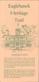 Bendigo Historical Society Inc.
Document - EAGLEHAWK HISTORICAL SOCIETY COLLECTION: EAGLEHAWK HERITAGE TRAIL
Small brochure titled: Eaglehawk Heritage trail, after an introduction a map of the points of interests, few drawing of different buildings, in total the brochure give small information on 33 locations.eaglehawk, history, walking tour -
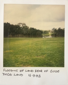 Kew Historical Society Inc
Photograph - Flooding at parkland at rear of Guide Dogs Victoria, 1993
The land currently occupied by Guide Dogs Victoria was once part of the grounds of the Kew Lunatic Asylum. This includes the land, designated as parkland which adjoins the Yarra River. It is now designated as the Chandler Park.Original colour small format polaroid photograph of flooding in parkland at the rear of Guide Dogs Victoria in the area now used as the Main Yarra Trail; taken on 16 September 1993."Flooding of land rear of Guide Dogs land 16.9.93"yarra river -- floods -- kew (vic.), guide dogs victoria, main yarra trail, chandler park -
 Kew Historical Society Inc
Photograph - Flooding of shared path at rear of Guide Dogs Victoria, 1993
The land currently occupied by Guide Dogs Victoria was once part of the grounds of the Kew Lunatic Asylum. This includes the land, designated as parkland which adjoins the Yarra River. Original colour small format polaroid photograph of flooding in parkland at the rear of Guide Dogs Victoria in the area now used as the Main Yarra Trail; taken on 16 September 1993."Flooding of shared path on 16.9.93 / Rains 15.9.93 - rear Guide Dogs [Victoria] land"yarra river -- floods -- kew (vic.), guide dogs victoria, main yarra trail, chandler park -
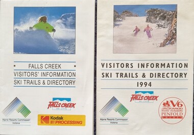 Falls Creek Historical Society
Flyer - Falls Creek Visitors Information 1992 & 1994
These publications were developed by the Falls Creek Ski Lifts Pty. Ltd. to promote activities and facilities at Falls Creek for the Winter Seasons of 1992 and 1994. They include maps of Falls Creek Village and the surrounding slopes as well as pricing for ski lifts and packages. Advertisements for Frying Pan Inn and Cloud 9 Restaurant are featured.These items are important because they document seasonal activities at Falls Creek Alpine Resort over time.Two glossy coloured flyers featuring images and information about skiing and trails at Falls Creek. Prices for different lift passes, ski gear rental and season passes are included.falls creek marketing, ski packages falls creek, falls creek trail maps, falls creek visitor information -
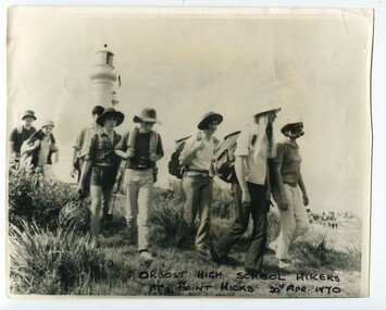 Orbost & District Historical Society
black and white photograph, 20th April 1970
The Captain Cook Bicentenary celebrations saw students from Orbost High School hiking around Cape Everard during the re-naming to Point Hicks.This item is associated with Orbost High School and the historynof education in Orbost. It is also associated with the Captain Cook Bicentenary, a significant event in Australia's history. A large black / white photograph of a group of students from Orbost High School on a hike at Point Hicks.They are carrying backpacks along a trail and the Point Hicks lighthouse can be seen in the background.education-orbost point-hicks captain-cook-bicentenary -
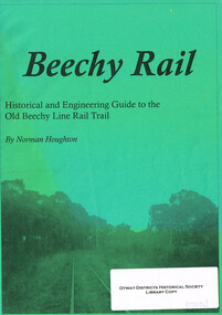 Otway Districts Historical Society
Book, Beechy Rail, 2005
Beechy Rail. Historical and engineering guide to the Old Beechy line rail trail. Norman Houghton. Geelong (Vic); Norman Houghton; 2005. i, 15 p.; illus. Soft cover.beechy; railway; history; engineering;