Showing 127 items
matching tree changers
-
 Bendigo Historical Society Inc.
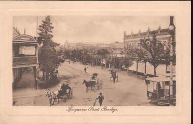
Postcard - HARGREAVES STREET, BENDIGO
Sepia tint postcard: image shows Hargreaves Street, Bendigo. Looking NE, trees on either side of street. Unpaved, three horse and traps in foreground, tram on RH side. Appears to be taken from Mitchell Street corner. Written on rear in black pen: Bendigo 27.1.15, Dear Merle (Bush?) Many thanks for your letter. Things have changed since I last wrote to you. I do not know when I will be going to Melbourne, so sill still be here when you return, I expect. Glad to hear you are having a good time. With love, Arthur.bendigo, streetscape, hargreaves street, bendigo, hargreaves street, bush. -
 Warrnambool and District Historical Society Inc.
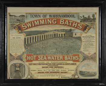
Photograph - Framed photograph of Warrnambool Salt Water Baths, c. 1920
This is a framed photograph of the men's pool at the Warrnambool Salt Water Baths. These Baths were originally built at the end of Gilles Street on the line of the present railway line in 1876 but were rebuilt in 1889 further north in Gilles Street when the railway line was opened. The water was pumped from the sea, initially by a windmill and later by a gas pump. The men's pool was 100 feet by 50 feet and the women's pool was 60 feet by 30 feet with bathing strictly segregated in the 19th century. A building nearby housed marble cubicles with hot spa baths with the water heated on the site and a caretaker's cottage completed the complex. Men's nude bathing was a feature of the early 20th century. Originally built by a local public company the Baths were taken over by the Warrnambool Council. These baths were superseded by the opening in 1961 of an Olympic Pool In Warrnambool. The site and the remaining buildings of the old sea water baths are now heritage-listed and today form part of the headquarters of the Warrnambool and District Historical Society.This photograph is of historical significance as a depiction of the Warrnambool Salt water Baths in the early 20th century. These Baths were the basis for promoting Warrnambool as a health and spa resort town in the late 19th and early 20th centuries.This is a framed black and white photograph of the men's pool at the Warrnambool Salt Water Baths. It depicts men and boys swimming in the circular pool and one male on the diving board. All these men are naked. There are other clothed males and clothed attendants wearing hats and waistcoats. The change rooms are on the right side of the photograph and there is a fence with trees behind. The photograph is mounted on cardboard with a gilt edge and is held in a wooden ridged frame behind glass. warrnambool sea water baths, sea baths, warrnambool pool, gilles street -
 Flagstaff Hill Maritime Museum and Village
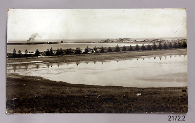
Photograph - Historical, maritime, Early 1900's
The photograph of Lady Bay, Warrnambool, and its surrounds reflects the historical changes to the area since since the early days of the Breakwater, from the 1870's. The foreground shows a lamppost with insulators, showing that electricity was supplied before or at the time.The subject of the photograph gives a reference point to the passage of time and the changes brought about in the growth of the town to a busy city, of the changes in transport and landscape and the management of the Bay.Photograph, sepia, showing Lady Bay, Middle Island, Lake Pertobe, railway line and cows in foreground, steam ship with smoke docked at the breakwater, small hut and larger building at start of breakwater, row of Norfolk pine trees across centre. There is a lamppost with white insulators in the foreground.flagstaff hill, warrnambool, shipwrecked-coast, flagstaff-hill, flagstaff-hill-maritime-museum, maritime-museum, shipwreck-coast, flagstaff-hill-maritime-village, photograph, warrnambool, lady bay, lake pertobe, cannon hill, middle island, steam ship, breakwater, warrnambool history, insulators, electricity, power, shed on breakwater -
 City of Kingston
Photograph - Colour, Circa 1993
Edithvale is a suburb in the City of Kingston. It is located between Aspendale and Chelsea on the Port Phillip Bay and built within remnant areas of the Carrum Carrum swamp. The foreshore precinct comprises a wide sandy beach, with low sand dunes and numerous historic boat sheds. The suburb consists of older style dwellings and former holiday houses, combined with mid-century housing and newer homes. The large blocks are increasingly subdivided and the existing dwellings demolished to accommodate units and townhouses, thus changing the landscape of the area and reducing the tree canopy.The beachside suburb of Edithvale was previously part of the extensive Carrum Carrum Swamp. The area was once a source of fish and eels for the Mayone-Bulluk clan of the Bunurong people. Over time the area was drained and predominantly devoted to dairy farming and holiday houses. The farms were gradually sold and subdivided with a large number of homes built after World War II and in the 1960s. Edithvale is mainly residential with a shopping strip along Nepean Highway but little significant industry was ever established in the area apart from a plaster works and confectionary factory, both now closed.Aerial colour photograph of Edithvale as viewed from Alexandra Avenue in the north to Ella Grove Chelsea/Edithvale in the south. The area is built-up with residential housing and facilities including Edithvale Primary School, numerous churches and the Edithvale Railway station. Large sections depict the remnant Carrum Carrum swamp. Edithvale Common and the former "Duck Inn" (Melbourne Water/Friends of Edithvale Seaford Wetlands) can be seen. Edithvale Recreational reserve, the velodrome and Edithvale Public Golf Course are prominent. The image shows vacant land in the area now known as Aspendale Gardens and the newer residential section of Chelsea Heights is not developed. A bike path has been established to cover the secondary drain. The Golf Links Court residential development located off Hughes Avenue is a large vacant block.Yellow circular adhesive sticker on plastic Black ink (marker): * (asterisk) Black type on white adhesive sticker: P000108edithvale, aspendale, chelsea, carrum carrum swamp -
 Stawell Historical Society Inc
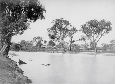
Photograph, ''Mokebilla" Station 1866
Mokebilla Station. Part of a collection of Photographs by Mr. O.G. Armstrong as commissioned by the Shire of Stawell for the Inter-colonial and Paris Exhibition in Melbourne in 1866. Charles Browning Hall was at the station for a short period in about 1840-41. Horatio Wils purchased Lexington from C.B. Hall in 1842. To this he added the stations of Larose and Mokebilla. Part of the property still remains along the Halls Gap Rd, by the bridge over the Mount William Creek. Note that the spelling has changed over the years and it is currently known as Mokepilly. Looking across water to Homestead and outbuildings behind large Gum Trees.stawell -
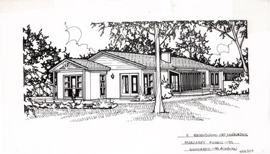 Whitehorse Historical Society Inc.
Artwork, other - Ink Line Drawing, Margaret Picken, 11 Ravenswood Crt., Nunawading, 1994
A property illustration by Margaret Picken Commissioned by a real estate agency for the purpose of advertising 111 Ravenswood Crt., Nunawading. This property is listed as having sold for $257,500 in 1994 Made by using Rotring ‘Rapidigraph’ drafting pens with Rotring ink on Rapidigraph polyester drafting film, double matte. Trained as a cartographic draftsman within the mining industry, Margaret Picken is an artist who worked producing property illustrations for real estate agencies in eastern suburbs of Victoria from 1983-2005. Retiring from the industry as technological changes favored coloured photography over illustrations, and commissioning companies over sole contractors.This artwork is of Historical Significance as a record of local domestic architecture.A black ink line drawing on drafters film by Margaret Picken, of a single story house as seen from a side angle. It features a glass 'lean-too' leading onto a patio. The lawn features a central tree, and garden beds. There are two hole punch holes centered along the upper edge11 Ravenswood Crt., Nunawading Marg. Picken - 93 Woodards - Blackburnwhitehorse historical society, schwerkolt cottage, housing, architecture, margaret picken, house, garden, real estate, nunawading -
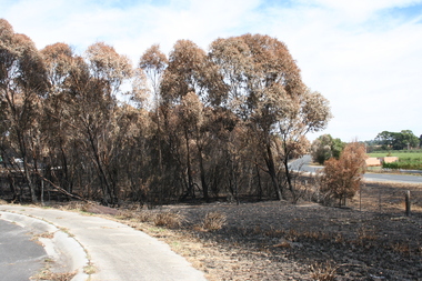 Sunbury Family History and Heritage Society Inc.
Photograph, Rosa McCall, February 2014
The cluster of trees beside the Calder Highway, north of Sunbury, were burnt in February 2014 when a grassfire started along the road and a severe wind change from the south took the flames across the dry countryside beyond Riddells Creek and beyond Clarkefield. The Bendigo rail line was damaged resulting in it being closed for repairs. This was one of the many fires experienced over that hot summer when the countryside was parched.A coloured digital photograph of a cluster of burnt trees by a roadsidegrassfires, calder highway, riddells creek