Showing 236 items matching "underground mining"
-
 Stawell Historical Society Inc
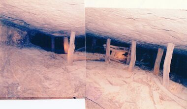
Photograph, Amalgamated Scotchman’s Mine at the 212 Metre underground level -- 2 Photos --Coloured
Amalgamated Scotchman’s Mine 212 metre levelstawell mining -
 Stawell Historical Society Inc
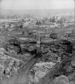
Photograph, Mining Scene Big Hill c1895-1890's with the Underground Road below Whim
Scene from Big HillB/W Big Hill Mining scene c. 1895-1890's : road into drive, whimstawell mining -
 Clunes Museum
Newspaper - NEWSPAPER CUTTING, THE ILLUSTRATED AUSTRALIAN NEWS
... NORTH CLUNES MINING CO. 3;UNDERGROUND WORKINGS OF NEW NORTH... & SURFACE OF NEW NORTH CLUNES MINING CO. 3;UNDERGROUND WORKINGS ...THE ABOVE PHOTOGRAPHS WERE TAKEN BY JOHN UNDERWOODPHOTOSTAT COPIES OF NEWS PAPER COLLECTION CUTTINGS FROM ILLUSTRATED AUSRALIAN NEWS. JUNE 17 th.1873. PHOTOSTAT COPY 1;RESERVOIR AND DAM OF CLUNES WATER SUPPLY. 2;SHAFT & SURFACE OF NEW NORTH CLUNES MINING CO. 3;UNDERGROUND WORKINGS OF NEW NORTH CLUNES MINING CO.17 JUNE 1878local history, document, newspaper cutting, mining -
Clunes Museum
Map - MAPS/DOCUMENTS
INFORMATIONDOCUMENTATION AND MAPS DESCRIBING THE WORKINGS OF THE PORT PHILLIP MINE, SHOWING 54 FEET DEEP OF THE UNDERGROUND WORKINGS.local history, mining, port phillip mine -
Stawell Historical Society Inc
Article - Realia, O.A. DAY, Miners Shovel from Underground Gold Mine, 1880's
This old miners shovel was found in the late 1980'8 or early 1990's in one of the underground Horse Stables in the abandoned workings of the old Magdala Mine. It was found covered in mud along with other mining equipment as well as some old clothing.Wooden Handled Mining Shovel Manufactured by O.A. DayO.A. DAYmining, gold mining -
 Stawell Historical Society Inc
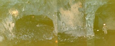
Photograph, Stawell Gold Mine, Stawell Gold Mine Drives Underground 1988
Workers standing in Stawell Gold Mine Underground Drives. One Drive showing rock backfillpanorama, gold, mining -
Stawell Historical Society Inc
Map, Underground Mine Workings Stawell, 1894
Plan and Elevations of mine workings 12 September 1894. J H Bate Mining Surveyor. Framed under Glassstawell, mining, plans -
Stawell Historical Society Inc
Map, Geological Survey Office, Sloanes & Scotchmans united Mine, December 1916
Sloane & Scotchman's Geological Survey Map 1916 Showing Underground DrivesGeological Survey Office Ballarat December 1916 mining, gold, map -
Stawell Historical Society Inc
Map, Charles C Reilly, Oriental & North Cross Reef Mine showing underground drives, 3/5/1900
Underground Survey of Mines Stawell c1900Charles C Reilley 3.5.00 mining, gold, map -
Stawell Historical Society Inc
Map, Sloanes & Scotchmans Company showing underground drives, c1900
Underground Workings Mapc1900Sloanes & Scotchmans Coy mining, gold, map -
Stawell Historical Society Inc
Map, Gold Mines of Australia, Gold Mines of Australia underground workings. Newington Rd Darlington Rd Area 1950, 1950
Plans Showing Surveys & Drilling Stawell InvestmentGold Mines of Australia Stawell Investment 2003 mining, gold, map -
Stawell Historical Society Inc
Map, G C Birch Mining Surveyor, Magdala Cum Moonlight Co. Plan of Stawell Goldfield, c1900
... Birch Mining Surveyor Showing underground drives. c1900 Magdala ...Shows Sloanes & Scotchmans Coy AreaShowing underground drives. c1900G C Birch Mining Surveyor mining, gold, map -
Stawell Historical Society Inc
Map, Crocodile Gold Corp, Photographic Aerial View of Big Hill showing underground workings and surface workings and proposed Big Hill Open Pit proposal, December 2014
Crocodile Gold Corp SGM photo Map showing Magdala Decline& Wonga Decline December 2014 Produced for Public Consultation over Big Hill Open Pit Proposal. Aerial Views Stawellmining, gold, map -
Stawell Historical Society Inc
Map, H C Bates Surveyor, Plan of Underground Workings. 1888, 25/8/1888
goldMagdala Co Now Moonlight Co StawellScale 80ft to an inch H C Bates Mining Surveyor 25/8/88mining -
Stawell Historical Society Inc
Map, Western Mining Corp / Stawell Joint Venture, Three dimensional View of Wonga Open Cut & Decline, April 1992
Cutaway perspective showing DeclinesView Looking North West with Cut Away Showing Underground Development Floorplanmining, gold -
Stawell Historical Society Inc
Map, Stawell Gold Mine, Plan Showing Wonga Pit and Underground Development, August 2001
Stawell Gold Mines Victoria Scale 1 : 2500mining, gold -
Stawell Historical Society Inc
Map, Stawell Gold Mine, Tenement Boundaries Stawell Township 2001, August 2001
Showing Underground Development Stawell Gold Mines Victoria Scale 1 : 20000mining, gold -
 Stawell Historical Society Inc
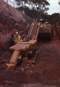
Photograph, Stawell Gold Mine
... grampians Gold Mining working on the underground decline Stawell ...working on the underground declinegold mining -
 Stawell Historical Society Inc
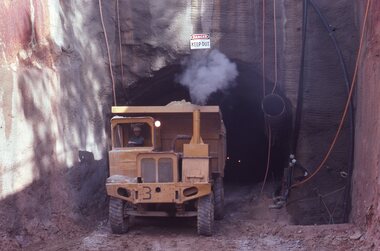
Photograph, Stawell Gold Mine
... grampians Gold Mining Truck exiting the Underground mine Stawell ...Truck exiting the Underground mine gold mining -
 Rutherglen Historical Society
Map, 1908
... and the words North of England Institute. Newcastle. Mining ...This is a map produced as part of a book entitled.. It is also stamped on the back in blue ink with an oval ring and the words North of England Institute. Newcastle. Mining & Meterolgical Faculty. Purchased on 23rd July 2017 by the Society after research by member Simon Killeen. Mining map of one of the first mines in Rutherglen area ( Chiltern West)Cream paper, black printing, rectangle with a drawingGeographical Survey of Victoria, Memoir, No6. Plate XX Plan of Underground Workings CHILTERN VALLEY CONSOLS MINE, RUTHERGLEN, PARISH OF CHILTERN WESTgold, rutherglen, mining, chiltern, underground mine map, geological survey, reef drives -
 Ballarat Heritage Services
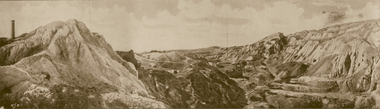
Photograph - Image - Black and White, Old Works, Black Hill Gully, Ballarat, c1904, c1904
... hours a day in 1865. Open cut mining then ceased. Underground...-rock (quartz) gold mining at Black Hill was the Black Hill ...The first company to make a success of hard-rock (quartz) gold mining at Black Hill was the Black Hill Company, formed in 1859. Mining from the open-cut mine probably commenced in 1860 and by 1861 the company had erected the largest stamping mill in Victoria. The mill ran 24 hours a day until the end of 1864 and 12 hours a day in 1865. Open cut mining then ceased. Underground ore extraction continued at Black Hill until the early twentieth century.Photographic image of the abandoned open-cut mine at Black Hill, Ballarat, c1904 ballarat, black hill, mining, open cut, gold -
 Bendigo Historical Society Inc.
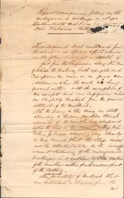
Document - MARKS COLLECTION: REPORT ACCOMPANYING PLAN ON THE BALLERSTEDT & SONS MINE, VICTORIA HILL
Handwritten two page document. On top of document: Report accompanying plan on the underground working in Messrs Ballerstedt & sons ( indecipherable word ) mine, Victoria Hill. This document refers to item 8300.bendigo, mining, ballerstedt & son mine -
 Bendigo Historical Society Inc.
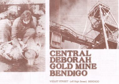
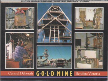
Document - JOAN O'SHEA COLLECTION: CENTRAL DEBORAH GOLD MINE BENDIGO, 26th November, 1984
Joan O'Shea Collection. Central Deborah Gold Mine Bendigo. Promotional material. Chronological History, Poppet legs and shaft, Change Room, Caretakers or rag pickers room, Drying room, first aid room, carbide light room, Underground, carpenters shed, ore bins and loading bays, stamper battery, wilfley table, berdan pans, laboratory, display room, boiler, stroke hold, winding engine, boiler feed pump, electric driven compressor, steam driven compressor, blacksmith's shop.Photograph Courtesy Philip Beer.mining, marketing, central deborah mine. -
 Bendigo Historical Society Inc.
Document - MCCOLL, RANKIN AND STANISTREET COLLECTION: SUNDRY REPORTS, 1930's
Manilla Folder containing reports from various mines in Bendigo and surrounding areas. 1. 4 page typewritten report on the Balaclava Hill Mine at Rushworth and some newspaper clippings about the mine with a plan of the underground workings; 2. Page from the Árgus' dated 2nd August 1900 featuring an article on the survey of the Garden line of Reefs; 3. 5 page report with maps on the Tooleen Gold Field; 4. Single page report about an unnamed mining area claimed to be on the southern end of the Deborah line of reef. (this could be the 'Three Jays' mine in Sedgwick. P. Wilkin); 5. Hand written report on the Coronation Mine, 2 miles east of Walhalla.; 6. Hand written report dated 1935, of the Queen Mary mine, St. Arnaud.; 7. 1932 report on the North Neangar lease.; 8 4 page report on the Kings Prize Gold Mining Syndicate.; 9. Description of the plant of the Marong Alluvial Company? Also a guide for marking out leases.; 10. Crushing details (1 page) from the 'Enterprise' Mine South of and adjacent to Perseverence.; 11. 1 page crushing details from Rowe Brothers, Mosquito Mine, Fryerstown.; 12 hand written report mentions Arthur Hatfield, Scarsdale.; 13. Map with lines of reef showing the position of the New Moon Consolidated and the New Moon United shafts.; 14, Large scale map from Harrison/Victoria street to Havilah Road showing the positions of the Carlisle, North Garden and Unity Shafts.gold mining, miners' safety cage, sundry reports, mining. bendigo, rushworth, balaclava hill, garden line of reef, toolleen, coronation mine, walhalla, queen mary mine, st. arnaud. north neangar, kings prize gold mining syndicate, marong, enterprise mine, perseverence, rowe brothers, mosquito mine, fryerstown, arthur hatfield, scarsdale, new moon consolidate, new moon united, carlisle, north garden, unity. -
 Bendigo Historical Society Inc.
Souvenir - Photographs: Central Deborah Mine
The Central Deborah Mine closed it's mining operations in 1954. The complete nature of the site encouraged the Bendigo City Council to purchase the site in 1970 in order that it be preserved. In 1971 the Bendigo Trust was formed and under its auspices the surface was opened to tourists in 1971' Extensive work enabled Level 2, underground to be opened to the public. This was followed in 1998 by Underground Level 3 Adventure tours. In 2011 visitors were able to tour as far down as Level 9, 228 meters below ground making it the deepest underground mine tour.Concertina souvenir six photographs of mining at Central Deborah Gold Mine Bendigo Victoria. Could be broken up to send as six separate postcardspostcards, central deborah mine -
 Bendigo Historical Society Inc.
Administrative record - Mining Wages Book
John S Wearne First Manager of the Specimen Hill Co. W.H. Thomas Manager from September 1873. OBITUARY. Residents of the Borough of Eaglehawk will regret to learn of the death of Mr. John Wearne, a former well-known member of that community. The late Mr. Wearne, who was 68 years of age, came to Victoria in 1857. He was the first manager of the Specimen Hill mine and was also largely interested in several other mines in the district. Some considerable time ago he retired from active pursuits, and went to reside at Strathfieldsaye, whence he removed to Ascot Vale some years ago, where he lived until his death, his remains were brought to Eaglehawk by the mid-day train yesterday and conveyed to the family vault in the Eaglehawk Cemetery, many friends joining the cortege. Six members of the family survive — two sons and four daughters — Mrs. Wearne having pre-deceased her husband some time ago. OBITUARY. Article - Bendigo Advertiser (Vic. : 1855 - 1918)Saturday 22 September 1906 - Page 5 Mining Company Pay book for a mining company. Dated from January 7, 1871 - February 12, 1876. Ledger format with six Columns - Name, Occupation. No. of Days, Rate, Amount, Signature on Receipt of Wages. First page lists J.S. Wearne as Manager, C. Palmer as Underground Manager, Miners - Rodda, Johns, Wearne, Kneebone, Trengove, Duncalf, Tresize. The ledger is in very poor condition and has been used by a child for drawing and writing practice.wages, mining, specimen hill mine -
 Bendigo Historical Society Inc.
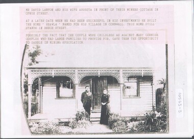
Photograph - Home of David and Augusta Lanyon
David Lanyon undertook many aspects of mining progressing to become the underground boss of the New Chum United Mine. In 1894 he became a member of the Bendigo Stock exchange and a successful speculator. He then moved into a new home, "Raelwa" in Beech St., GoldenSquare. This substantial home was designed by architect, Mr William Beebe10563.3a David & Augusta Lanyon outside their (Miner's Cottage) home in Ophir Street, Bendigo. Later after his success with investments he built a home in Beech Street which he named "Reawla" after his village in Cornwall. 10563.3b photocopy of Mr. David Lanyon, who made a fortune speculating ion the Bendigo Mines From undated photographsdavid lanyon, reawla, miner's cottage -
Bendigo Historical Society Inc.
Letter - Kangaroo Flat Gold Mine Collection: Mining Lease 1345
One page letter from Department of Industry, Technology and Resources to George H. White, Development Manager, Western Mining Corporation, Eaglehawk, re mining lease no. 1345, Bendigo Gold Project. Approval of a working proposal for evaluation at the Carshalton Shaft has been sought by Western Mining Corporation. The Department of Industry, Technology and Resources 'hereby approves the proposed underground exploration at South Carshalton Shaft including the dewatering activities outlined in your report dated July 1987'. The Minister for Planning, Jim Keenan, has exempted the exploration works from the Environment Effects Statement. Shire of Strathfieldsaye have issued a planning permit. western mining corporation, department of industry, technology and resources, dewatering, carshalton shaft, environment effects, shire of strathfieldsaye -
 Stawell Historical Society Inc
Memorabilia - Realia, c1900's
... Mining Relic found underground - Trolley Wheel... grampians Stawell Mining Relic found underground - Trolley Wheel ...Mining Relic found underground - Trolley Wheelstawell -
Stawell Historical Society Inc
Map, Plan of the Principal Underground Workings at Stawell, 1894
Plan of the Principal Underground Workings at Stawellstawell, mining