Showing 269 items matching "valley lake"
-
 Warrnambool and District Historical Society Inc.
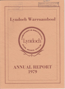
Document - Lyndoch Warrnambool 1979 Annual Report, 1979
This is the 1979 Annual Report for Lyndoch Home and Hospital for the Aged, Warrnambool. It contains lists of Board Members, a President’s Report, a sketch of a proposed new building, financial reports, photographs and a list of Life Governors. Lyndoch Home for the Aged was established in 1952 and has developed with a wide range of facilities for the aged since that date. The original Lyndoch property near the mouth of the river Hopkins was owned by a Melbourne tea merchant, George Rolfe, who bought the land when there were only on the site a couple of cottages and a larger building which had been a school, Warrnambool Grammar, run by Henry Kemmis. Rolfe acquired the land in the 1870s and named the property Lyndoch after the town in the Barossa Valley where he had lived. He owned Lyndoch for 44 years and it was his stepdaughter, Florence Lake who built in the 1920s the bungalow known as Lyndoch which forms the original building of the Lyndoch Home for the Aged. Today the facility is called Lyndoch Living.This report is kept for the benefit of researchers wanting details of the history of Lyndoch over the past thirty or forty years.This is a booklet with a cardboard buff-coloured cover. There are six double-sided pages with printed material on white paper with a yellow and orange stripe across the top of the pages.On front cover: Lyndoch Warrnambool, Annual Report 1979 In brown circle on front cover: Lyndoch, Comfort and Security for Aged Folk Two library stamps on front cover (Warrnambool Library) lyndoch, aged care facility, warrnambool, hopkins, warrnambool grammar -
 Warrnambool and District Historical Society Inc.
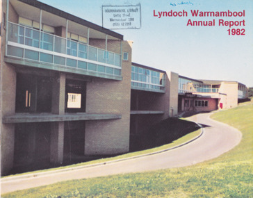
Document - Lyndoch Warrnambool 1982 Annual Report
This is the 1982 Annual Report for Lyndoch Home and Hospital for the Aged, Warrnambool. It contains lists of Board Members, a President’s Report, Lyndoch’s Aims, financial reports, photographs and a list of Life Governors. Lyndoch Home for the Aged was established in 1952 and has developed with a wide range of facilities for the aged since that date. The original Lyndoch property near the mouth of the Hopkins River was owned by a Melbourne tea merchant, George Rolfe, who bought the land when there were on the site only a couple of cottages and a larger building which had been a school, Warrnambool Grammar, run by Henry Kemmis. Rolfe acquired the land in the 1870s and named the property Lyndoch after the town in the Barossa Valley where he had lived. He owned Lyndoch for 44 years and it was his stepdaughter, Florence Lake who built in the 1920s the bungalow known as Lyndoch which forms the original building of the Lyndoch Home for the Aged, Today the facility is called Lyndoch Living. This 1982 report is kept for the benefit of researchers wanting details of the history of Lyndoch over the past 30 or 40 years. This is a booklet with a plasticized cover with a white back and a multi-coloured front cover. The front cover has a photograph of a Lyndoch building. There are six double-sided pages with printed material and photographs on white paper and a yellow and orange strip across the top of the pages. The pages are stapled.On front cover: Lyndoch Warrnambool Annual Report 1982 Stamp of Warrnambool Library On back cover: A red circle with the words ‘Lyndoch, Comfort and Security for Aged Folk’ lyndoch aged care facility, warrnambool, lyndoch warrnambool -
 Warrnambool and District Historical Society Inc.
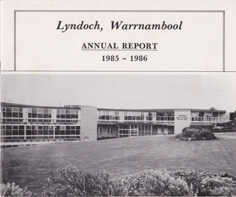
Document - Lyndoch Warrnambool Annual Report 1985-86, 1986
This is the 1985-6 Annual Report for Lyndoch Home and Hospital for the Aged, Warrnambool. It contains lists of Board Members, a President’s Report, photographs, Lyndoch’s Aims, financial reports and a list of Life Governors. Lyndoch Home for the Aged was established in 1952 and has developed with a wide range of facilities for the aged since that date. The original Lyndoch property near the mouth of the River Hopkins was owned by a Melbourne tea merchant, George Rolfe, who bought the land when there were on the site only a couple of cottages and a larger building which had been a school, Warrnambool Grammar, run by Henry Kemmis. Rolfe acquired the land in the 1870s and named the property Lyndoch after the town in the Barossa Valley where he had lived. He owned Lyndoch for 44 years ad it was his stepdaughter Florence Lake who built in the 1920s the bungalow known as Lyndoch which forms the original building of Lyndoch Home for the Aged. Today the facility is called Lyndoch Living. This 1985-6 report is kept for the benefit of researchers wanting details of the history of Lyndoch over the past 30 or 40 years.This is a booklet with a plasticized white cover with a black and white photograph of a Lyndoch building on the front cover. There are eight double-sided pages with printed material and photographs. The pages are stapled.On front cover: ‘Lyndoch, Warrnambool, Annual Report, 1985-1986 On back cover: A black circle with the words: ‘Lyndoch, Comfort and Security for Aged Folk’. lyndoch aged care facility, warrnambool -
 Emerald Museum & Nobelius Heritage Park
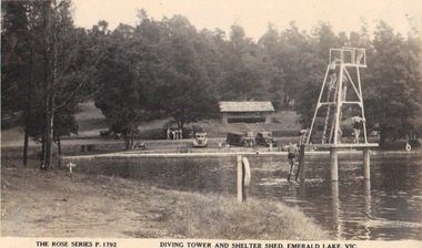
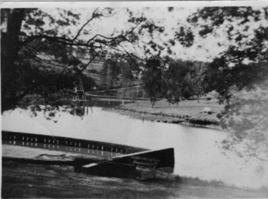
Photograph/postcard, Rose Series Postcard - Diving Tower and Shelter Shed, Emerald Lake. Victoria, late 1940's
Photograph of Emerald Park Lake showing diving tower circa late 40'sFront: The Rose Series P. 1792 'Diving Tower and Shelter Shed, Emerald Lake, Vic. emerald park lake, rose series postcards -
 Emerald Museum & Nobelius Heritage Park
Photograph, Rose Series Postcard - Diving Tower and Shelter Shed, Emerald Lake. Victoria, circa 1940 - 50
Depicting early years of Emerald Lake Photograph of Emerald Park Lake showing diving tower circa 40'sFront: The Rose Series P. 1792 'Diving Tower and Shelter Shed, Emerald Lake, Vic. emerald park lake, rose series postcards -
 Emerald Museum & Nobelius Heritage Park
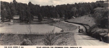
Photograph/postcard, The Rose Series P.564 'Road Around Swimming Pool, Emerald, Vic, circa 1930's - 40's
Postcard depicting Emerald Park Lake Postcard/photograph from the Rose SeriesFront: The Rose Series P. 564 'Road around the Swimming Pool, Emerald, Vic. Back: Published b y the Rose Stereograph Co. Armadale Vic. rose series, swimming pool, emerald park lake -
 Emerald Museum & Nobelius Heritage Park
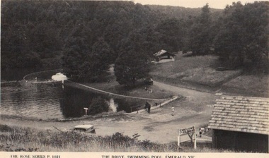
Photograph/postcard, The Rose Series P.1021 'The Drive, Swimming Pool, Emerald, Vic, circa 1930's - 40's
Emerald Park Lake - early photographEarly postcard depicting Emerald Park LakeFront: The Rose Series P.1021, 'The Drive, Swimming Pool, Emerald, Vic. Back:: Published by the Rose Stereograph Co. Armadale Victoriarose series, swimming pool, emerald park lake -
 Emerald Museum & Nobelius Heritage Park
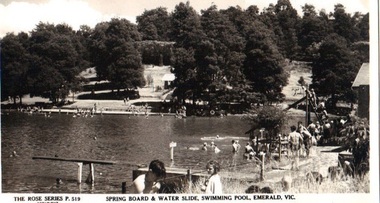
Postcard - B/W, Spring Board and Water Slide, Swimming Pool, Emerald, Vic
Recreational activities and provisions at Emerald Park Lake circa 1940sPostcard made from black and white photograph. Many bathers at Emerald Park Lake Swimming Pool. Springboard in foreground, water slide on right to the rear. FRONT: 'The Rose Series', P 519 COPYRIGHT' 'Springboard & Water Slide, Swimming Pool, Emerald, Vic.' REAR: Rose illustration in centre, flanked by 'POST CARD' and "The "Rose" Series Deluxe', 'A Real Photograph Produced in Australia'. Along left: 'Published by the Rose Stereograph Co., Armadale, Victoria'.emerald park lake, rose series, swimming pool -
 Emerald Museum & Nobelius Heritage Park
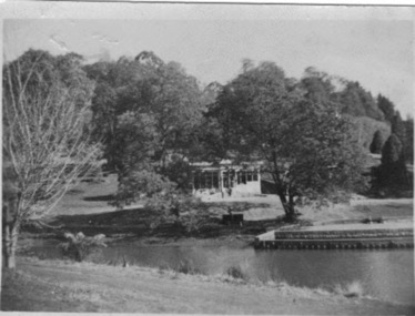
B/W Photograph, Emerald Park Lake c. 1960, 1960
The Stone family were migrants from Wales, living at the Fisherman's Bend Migrant Hotel around 1960. This photograph was taken on a day trip to Emerald Park Lake.The photograph shows the state of Emerald Park Lake around 1960.B/W photograph, looking across a stretch of Emerald Lake towards a building in the background, probably the kiosk.REAR: stamp "Ilford 260"emerald park lake -
 Emerald Museum & Nobelius Heritage Park
B/W Photograph, Emerald Lake Park c. 1960, 1960
The Stone family were migrants from Wales, living at the Fisherman's Bend Migrant Hotel around 1960. This photograph was taken on a day trip to Emerald Park Lake.The photograph shows the state of Emerald Park Lake around 1960.B/W photograph, looking across a stretch of Emerald Lake. Feature in background left might be diving platform.REAR: Ilford 260emerald park lake -
 Orbost & District Historical Society
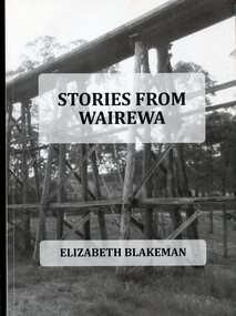
Book, Stories From Wairewa, 2017
This book is a social history collected orally and from the private records of residents of the Wairewa Valley, Victoria, Australia. It includes a brief history of the old primary school. Appended is a performance piece 'Waltz for Wairewa", a dialogue with poems and songs. It was sponsored by the Hospital Creek Bush Band and Dance Group. The book was partly the result of two song writing courses, one run on-line for six weeksby Sheffield University, U.K., and another year-long course at U3A in Lakes Entrance, East Gippsland. The bridge pictured on the front cover is O'Grady's railway bridge which was severely damaged in the bushfires of January 2020.This item is a useful reference on the history of the Wairewa Valley, East Gippsland.A soft covered book, titled "Stories From Wairewa". On the front cover is a tall wooden rail bridge. the book contains stories, photographs, scanned documents, shet music, drawings and poetry. book-wairewa blakeman-elizabeth school-wairewa -
 Marysville & District Historical Society
Postcard (item) - Colour postcard, Graphic Print Postcards, Marysville, Vic, 2004
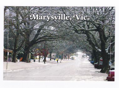
A colour photograph of a snow covered Murchison Street in Marysville in Victoria.A colour photograph of a snow covered Murchison Street in Marysville in Victoria. This photograph was taken in 2004 before the 2009 Black Saturday bushfires that destroyed most of the businesses in the main street.Marysville's main street covered with a light layer of snow. Marysville is a small country town in Victoria, just 10/ minutes from Lake Mountain, one of Australia's best/ Cross Country Skiing Resorts. Graphic in Print/ Postcards Place/ Stamp/ Here Graphic in Print/ Country Towns Collection/ Classic 2/ c 2004/ Ph: (03) 5966 8523 Fax: (03) 5966 8458 Mob: 418 593 534marysville, victoria, murchison street, snow, postcard, souvenir, graphic in print, country town collection -
 Marysville & District Historical Society
Postcard (item) - Colour postcard, Graphic Print Postcards, Marysville, Vic, 2004
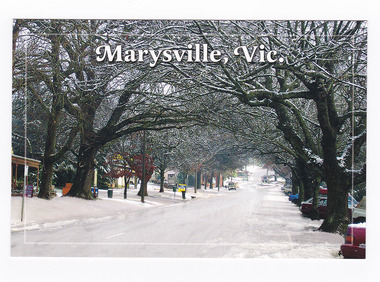
A colour photograph of a snow covered Murchison Street in Marysville in Victoria.A colour photograph of a snow covered Murchison Street in Marysville in Victoria. This photograph was taken in 2004 before the 2009 Black Saturday bushfires that destroyed most of the businesses in the main street.Marysville's main street covered with a light layer of snow. Marysville is a small country town in Victoria, just 10/ minutes from Lake Mountain, one of Australia's best/ Cross Country Skiing Resorts. Graphic in Print/ Postcards Place/ Stamp/ Here Graphic in Print/ Country Towns Collection/ Classic 2/ c 2004/ Ph: (03) 5966 8523 Fax: (03) 5966 8458 Mob: 418 593 534marysville, victoria, murchison street, snow, postcard, souvenir, graphic in print, country town collection -
 Marysville & District Historical Society
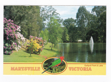
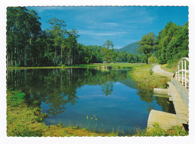
Postcard (item) - Colour postcard, Neil Cutts, Marysville Victoria-Gallipoli Park & Lake, Pre 2009
A postcard in a series produced by the Rose Stereograph Company in Victoria, Australia as a souvenir of Marysville.A colour photograph of Gallipoli Park and Darmody's Lake in Marysville, Victoria. Darmody was a prominent builder at one time in Marysville and this lake was named after him. The Rose Series postcard No. 3529.MARYSVILLE VICTORIA/ Gallipoli Park & Lake POST CARD The "Rose" Series/ De Luxe Proudly Printed in/ Australia Since 1880 AFFIX/ STAMP/ HERE/ Rose Series/ Post Card No./ 3529 ADDRESS/ POSTCODE Beautiful Gallipoli Park and Lake/ MARYSVILLE, VICTORIA, AUSTRALIA/ Photos Neil Cutts Copyright Rose Stereograph Co., Glen Waverley, Victoria (03) 9560 7772marysville, victoria, gallipoli park, postcard, souvenir, rose stereograph co, 3529, darmody's lake -
 Marysville & District Historical Society
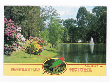
Postcard (item) - Colour postcard, Nucolorvue Productions Pty. Ltd, Marysville Victoria-Darmody's Lake, 2002
A colour photograph of Darmody's Lake in Marysville in Victoria.A colour photograph of Darmody's Lake in Marysville in Victoria. Darmody was a prominent builder at one time in Marysville and the lake was named after him. This postcard was produced by Nucolorvue Productions as a souvenir of MarysvilleMARYSVILLE, VICTORIA/ Darmody's Lake NU-COLOR-VUE/ AUSTRALIA'S NATIONAL POSTCARD COMPANY AFFIX/ STAMP/ HERE/ 17MA001/ NCV 7777 ADDRESS/ POSTCODE COPYRIGHT Nucolorvue Productions Pty. Ltd./ Telephone: (03) 560-1788/ Made in Australiamarysville, darmody's lake, darmody, victoria, nucolorvue productions, postcard, souvenir -
 Marysville & District Historical Society
Postcard (item) - Colour postcard, Nucolorvue Productions Pty. Ltd, Marysville Victoria-Darmody's Lake, 2002
A colour photograph of Damody's Lake in Marysville in Victoria.A colour photograph of Darmody's Lake in Marysville in Victoria. Darmody was a prominent builder at one time in Marysville and the lake was named after him. This postcard was produced by Nucolorvue Productions as a souvenir of MarysvilleMARYSVILLE, VICTORIA/ Darmody's Lake NU-COLOR-VUE/ AUSTRALIA'S NATIONAL POSTCARD COMPANY AFFIX/ STAMP/ HERE/ 17MA001/ NCV 7777 ADDRESS/ POSTCODE COPYRIGHT Nucolorvue Productions Pty. Ltd./ Telephone: (03) 560-1788/ Made in Australiamarysville, darmody's lake, darmody, victoria, nucolorvue productions, postcard, souvenir -
 Marysville & District Historical Society
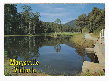
Postcard (item) - Colour postcard, Nucolorvue Productions Pty. Ltd, Marysville-Victoria, Pre 2009
A colour photograph of Darmody Lake in Gallipoli Park in Marysville in Victoria. A colour photograph of Darmody Lake in Gallipoli Park in Marysville in Victoria. Darmody was a prominent builder at one time in Marysville and the lake was named after him. This postcard was produced by Nucolorvue Productions Pty. Ltd. as a souvenir of Marysville.Reflections of Darmody Lake in Gallipoli/ Park. NU-COLOR-VUE/ OF/ AUSTRALIA AFFIX/ STAMP/ HERE/ 17 MA008/ NCV 4939 ADDRESS/ POSTCODE COPYRIGHT/ Nucolorvue Productions Pty. Ltd./ Telephone: (03) 560-1788/ Made in Australiamarysville, darmody lake, gallipoli park, victoria, nucolorvue productions, postcard, souvenir, darmody -
 Marysville & District Historical Society
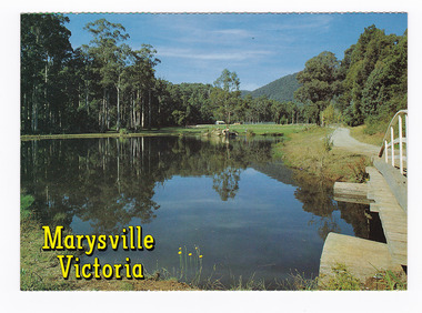
Postcard (item) - Colour postcard, Nucolorvue Productions Pty. Ltd, Marysville-Victoria, Pre 2009
A colour photograph of Darmody Lake in Gallipoli Park in Marysville in Victoria.A colour photograph of Darmody Lake in Gallipoli Park in Marysville in Victoria. Darmody was a prominent builder at one time in Marysville and the lake was named after him. This postcard was produced by Nucolorvue Productions Pty. Ltd. as a souvenir of Marysville.Reflections of Darmody Lake in Gallipoli/ Park. NU-COLOR-VUE/ OF/ AUSTRALIA AFFIX/ STAMP/ HERE/ 17 MA008/ NCV 4939 ADDRESS/ POSTCODE COPYRIGHT/ Nucolorvue Productions Pty. Ltd./ Telephone: (03) 560-1788/ Made in Australiamarysville, darmody lake, gallipoli park, victoria, nucolorvue productions, postcard, souvenir -
 Marysville & District Historical Society
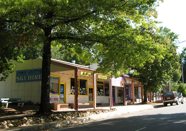
Photograph (Item) - Colour photograph, Unknown
A digital copy of a colour photograph of Cross Country Ski Hire in Marysville in Victoria.A digital copy of a colour photograph of Cross Country Ski Hire in Marysville in Victoria. This building, along with most of the town of Marysville, was destroyed in the 2009 Black Saturday bushfires.marysville, victoria, cross country ski hire, ski hire, lake mountain, 2009 black saturday bushfires -
 Marysville & District Historical Society
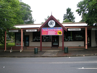
Photograph (Item) - Colour photograph, Unknown
A digital copy of a colour photograph of Cross Country Ski Hire in Marysville in Victoria.A digital copy of a colour photograph of Cross Country Ski Hire in Marysville in Victoria. This building, along with most of the town of Marysville, was destroyed in the 2009 Black Saturday bushfires.marysville, victoria, cross counry ski hire, lake mountain, 2009 black saturday bushfires -
 Marysville & District Historical Society
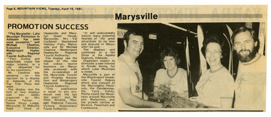
Newspaper (Item) - Newspaper article, Mountain Views, Marysville Promotion Success, 14-04-1981
A newspaper article reflecting on the success of a display to promote Marysville and Lake Mountain. This display was the first of four displays over two weeks which was organised by Mrs. Connie Pannan from Nanda Binya Lodge in Marysville; Counselor Malcolm Reed from the Shire of Healesville and Marylyn Guest House in Marysville; Mrs. Val Cockerell from Blackwood Holiday Flats in Marysville; and Mr. Michael Cheshire from the Westernport Healesville Regional Tourist Authority. The display saw the release of a new full colour tourist brochure on Marysville produced with the co-operation of the Marysville Tourist and Progress Association and Westernport Healesville Regional Tourist Authority. It was deemed to be a most successful promotional event for Marysville and Lake Moutain.A newspaper article reflecting on the success of a display to promote Marysville and Lake Mountain. The Association was formed in November 1907 to promote tourism within the area. This included the physical creation of signage, parklands, roads and walks to various attractions. marysville, victoria, lake mountain, marysville tourist and progress association, newspaper article -
 Marysville & District Historical Society
Ephemera (Item) - President's Report, Malcolm Reed, Marysville and District Tourist & Progress Association-President's Report 1981-82, 1982
Marysville and District Tourist & Progress Association-President's Report 1981-82. The report outlines the events and activities that the Association and its members were involved in and organised in the year of 1981 to 1982. At the time of this report Malcolm Reed was the President of the Association.Marysville and District Tourist & Progress Association-President's Report 1981-82. The Association was formed in November 1907 to promote tourism within the area. This included the physical creation of signage, parklands, roads and walks to various attractions. marysville, victoria, lake mountain, marysville tourist and progress association, president's report -
 Marysville & District Historical Society
Ephemera (Item) - Treasure's Report, Treasurer's Report 27/1/82, 27-01-1982
Marysville Tourist & Progress Association-Treasurer's Report-27/1/82Marysville Tourist & Progress Association-Treasurer's Report-27/1/82 The Association was formed in November 1907 to promote tourism within the area. This included the physical creation of signage, parklands, roads and walks to various attractions. marysville, victoria, lake mountain, marysville tourist and progress association, treasurer's report -
 Marysville & District Historical Society
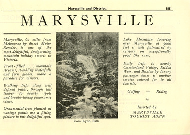
Ephemera (Item) - Magazine page, Marysville and District-Marysville, Unknown
... association lake mountain cumberland valley eildon weir buxton cora ...A magazine page showcasing Marysville and attractions and activities to do in and around Marysville and the district. This article was inserted into the magazine by the Marysville Tourist Association. The Association was formed in November 1907 to promote tourism within the area. This included the physical creation of signage, parklands, roads, and walks to various attractions. A magazine page showcasing Marysville and attractions and activities to do in and around Marysville and the district.marysville, victoria, marysville tourist association, lake mountain, cumberland valley, eildon weir, buxton, cora lynn falls -
 Marysville & District Historical Society
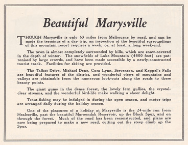
Ephemera (Item) - Advertisement, Beautiful Marysville, Unknown
An advertisement for Marysville and attractions in and around the local area.An advertisement for Marysville and attractions in and around the local area.marysville, victoria, lake mountain, talbot drive, lady talbot drive, michael dene, cora lynn falls, stevenson falls, steavenson falls, keppel's falls, healesville, maroondah reservoir, black spur -
 Marysville & District Historical Society
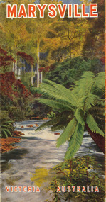
Ephemera (Item) - Tourist brochure, Victorian Railways, Marysville Victoria Australia, 01-1941
A tourist information brochure that was issued by the Publicity and Tourist Services of Victorian Railways, in January, 1941, to promote Marysville and the surrounding district.A tourist information brochure that was issued by the Publicity and Tourist Services of Victorian Railways, in January, 1941, to promote Marysville and the surrounding district.marysville, victoria, cumberland valley, messmate, buxton, taggerty river, acheron way, black's spur, cement creek, keppel falls, steavenson falls, cumberland falls, narbethong, st fillan, taggerty valley, wade's lookout, mount gordon, nicholls lookout, lake mountain, victorian government tourist bureau, victorian railways -
 Marysville & District Historical Society
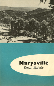
Ephemera (Item) - Tourist brochure, Victorian Railways, Marysville Victoria Australia, 11-1958
A tourist brochure showing information for travel to Marysville from Melbourne and accommodation venues in Marysville. This brochure was published by the Victorian Railways Public Relations and Betterment Board in November, 1958.A tourist brochure showing information for travel to Marysville from Melbourne and accommodation venues in Marysville.marysville, victoria, australia, marysville hotel, the cumberland, kerami guest house, kooringa guest house, marylands guest house, mary-lyn guest house, marysville chalet guest house, marysville house guest house, mt kitchener guest house, lake mountain, mckenzie tourist services, melbourne, great dividing range, cumberland valley, white mountain ash, eildon weir, alexandra, acheron way, warburton, victorian government tourist bureau, victorian railways -
 Marysville & District Historical Society
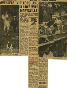
Newspaper (Item) - Newspaper article, The Argus Newspaper et al, Overseas visitors are in love with Marysville, 06-12-1955
A digital copy of a newspaper article regarding the need for the government of the time to make improvements on roads and to infrastructure at tourist sites in the Marysville area.A digital copy of a newspaper article regarding the need for the government of the time to make improvements on roads and to infrastructure at tourist sites in the Marysville area.Souvenir/ written by/ GORDON/ WILLIAMS/ and/ PERCY/ TAYLOR/ Photography/ by/ JACK/ LAWRENCEmarysville, victoria, newspaper article, the argus, jack lawrence, gordon williams, percy taylor, marysville tourist and progress association, lake mountain, steavenson falls, talbot drive, keppel falls, taggerty river -
 Marysville & District Historical Society
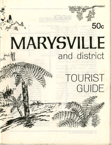
Booklet (Item) - Tourist guide, Ian and Danese Walshe et al, MARYSVILLE and district TOURIST GUIDE, 1982
A tourist guide outlining services, accommodation, activities and places of interest to visit in and around Marysville and the local district.A tourist guide outlining services, accommodation, activities and places of interest to visit in and around Marysville and the local district.marysville, victoria, australia, tourist guide, marysville hotel, castles' store, hawthorne's corner shop, tudor lodge, black spur motel and caravan park, buxton general store, golden fleece roadhouse, marysville garage, burrengeen park, lake mountain, steavenson falls, nanda binya lodge, alpenglow nursery, black spur inn hotel, silver stream trout farm, mccfarlane's grocery, barton's drapery, marysville newsagency, eildon explorer, beauty spot nursery, crossways, pumpernickel, mckenzie's tourist services, blue hills riding school, mountain view horse hire, pitt's garage, maryton park, j l gould sawmill, eildon deer park, eildon weir, maroondah dam, snob's creek, healesville sanctuary, graceburn park, cathedral range, beauty spot walk, tree fern gully walk, michaeldene track, keppel track, woods lookout track, cumberland scenic reserve, cambarville, the big tree, cora-lyn falls, barton's lookout, cumberland falls, sovereign view, wirreanda festival, scenic motel, tower motel, marylands guest house, kooringa guest house, marylyn guest house, mountain lodge, el kanah, marysville hotel motel, buxton hotel motel, black spur inn, buxton caravan park, marysville caravan park, the cumberland, marysville recreation and fun park