Showing 7351 items
matching valley road
-
 Whitehorse Historical Society Inc.
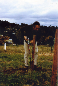
Photograph, John Addie at Yarran Dheran
... John Addie, then of Wattle Valley Road , Mitcham was made... Mitcham melbourne John Addie, then of Wattle Valley Road , Mitcham ...John Addie, then of Wattle Valley Road , Mitcham was made citizen of the year for the City of Nunawading for his leadership role in liaising with Nunawading Council re the formation of the Yarran Dheran Nature Reserve. Coloured photo of John Addie turning the first sod at a ceremony to mark the beginning of Yarran Dheran project in early 1970s.addie john, yarran dheran, parks and reserves -
 Kew Historical Society Inc
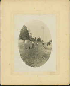
Photograph - Construction of the electric tram line in Riversdale Road, Camberwell
... Verso: "Riversdale Road between Wattle Valley and Highfield... between Wattle Valley and Highfield Roads" Digital copy ...One of a series of photographs, taken by Edgar James Dower in the second decade of the twentieth century. Born and raised in Olinda, his family later moved to Surrey Hills. He worked as an adult as a clerk in the city office of the Metropolitan Gas Company, and in his role as a 'collector', he was able to photograph scenes including the construction of tramlines, railways and associated buildings in Kew, Hawthorn, Camberwell and Surrey Hills. Later he established a real estate agency with his brother - the E.J. Dower Real Estate Agency, Dandenong Office.The image is an historically significant record of the development of transport infrastructure which was used to connect Victorians in the first two decades of the twentieth century. This development resulted from increases in population and the consequent extension of Melbourne's suburbs. The photographs, both individually and collectively, richly detail the labour of workers and the tools and machinery used to create and extend Melbourne's public transport network in the years preceding and during World War 1.Digital copy of an original mounted photograph showing workers excavating Riversdale Road, Camberwell, in preparation for the laying of the new electric tramline.Verso: "Riversdale Road between Wattle Valley and Highfield Roads"theme -- connecting victorians by transport and communications, riversdale road - camberwell (vic.), theme -- travelling by tram -
 Coal Creek Community Park & Museum
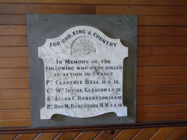
Honour Roll, Bena Presbyterian Church Honor Board
... Previously in the Bena Presbyterian Church, Bass Valley... Valley Road, Bena, 3946, now displayed on the west wall ...Previously in the Bena Presbyterian Church, Bass Valley Road, Bena, 3946, now displayed on the west wall in the church at Coal Creek Community Park and Museum, 12 Silkstone Road, Korumburra, 3950.One of the few remaining Bena town historic records.Honour roll of a white with grey marble shield on grey slate back plate. Title and names in black, inscribed into the marble shield with the Australian Commonwealth Military Forces insignia carved under the title. For God, King and Country, In Memory of the following men who were killed in action in France. Pte. Clarence Bell 11.6.18; Cpt. Wm. Irvine Glasgow, 1.9.18; Sgt. Allan C. Robertson, 14.4.18; Pte. Roy M. Robertson, M.M. (Military Medal), 3.4.18; bena, honour roll, church, wwi -
 Halls Gap & Grampians Historical Society
Photograph - B/W, C 1950s (?)
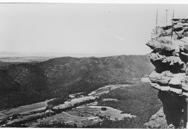
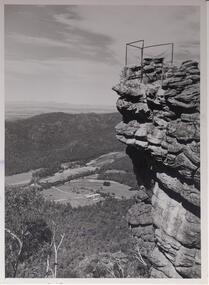
... the middle of the valley is Grampians Road..... View of a valley with cleared land, roads and buildings... of the valley is Grampians Road. SCENERY Fyans Valley A rocky outcrop ...Photograph is of Fyans Valley taken from Bellfield Peak. The mountain range across the centre of the scene runs north to south. The large dwelling centre-front is Bellfield Hotel, which was destroyed by fire in the 1960s. The main road running through the middle of the valley is Grampians Road.A rocky outcrop, far right, with metal fence and posts. View of a valley with cleared land, roads and buildings in foreground. Further cleared land can be seen beyond a mountain range that is in the centre of the photograph.scenery, fyans valley -
 Linton and District Historical Society Inc
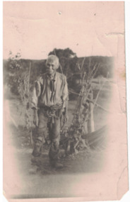
Photograph, Jimmy Lee Ching, Linton, circa 1900
... . The photograph shows Jimmy in his market garden on Snake Valley Road.... The photograph shows Jimmy in his market garden on Snake Valley Road ...Black and white image of a man with moustache, wearing working clothes and boots. Bundles of twigs propped against fence post and rail behind him. The clothing appears quite ragged in appearance. His trousers are held up by rope tied at his waist. Jimmy was said to be the last Chinese miner to live in the Linton area. The photograph shows Jimmy in his market garden on Snake Valley Road, Linton, circa1900.jimmy lee ching, chinese, miners, linton -
 Halls Gap & Grampians Historical Society
Photograph - B/W, C 1960s
... and overlooking a valley with roads,some cleared areas and buildings... by a wire fence and overlooking a valley with roads,some cleared ...Lookout is known as 'The Pinnacle'. Valley is the Fyans Valley.Photo shows rocky outcrop surrounded by a wire fence and overlooking a valley with roads,some cleared areas and buildings. The Mt. William range can be seen middle left in the photo.On back notes "bellfield' but neither Bellfield Peak or Bellfield lookout can be seen.scenery, lookouts -
 Ringwood and District Historical Society
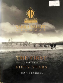
Book, Yarra Valley Grammar School - The First 50 Years - 1966-2015
... History of Yarra Valley Grammar School, Kalinda Road... Road Ringwood North melbourne History of Yarra Valley Grammar ...History of Yarra Valley Grammar School, Kalinda Road, Ringwood. -
 The Beechworth Burke Museum
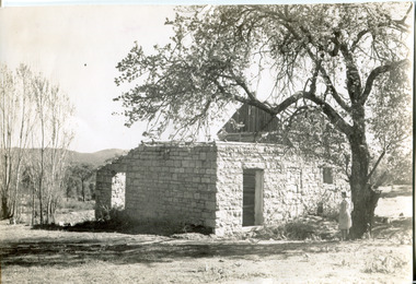
Photograph, Approximately 1930
... Wooragee road). The Wooragee Valley, approximately five... Wooragee road). The Wooragee Valley, approximately five ...Taken in approximately 1930, this photograph depicts the ruins of Rosehill Dairy. A woman stands beside the ruins, observing them solemnly. The owner of this once prominent dairy, John Brewer, was born in Cornwall, England in 1832. After coming to Australia in 1849, Brewer worked in various forms of livestock transportation. Upon hearing of the vast discovery of gold in Victoria's north-east, he engaged in mining in the Ovens Goldfield district before starting his own dairy on Wooragee road (now Old Wooragee road). The Wooragee Valley, approximately five kilometres north of Beechworth, was used extensively during the nineteenth century to build farming practices in the area, possessing eighteen farms by 1860. Brewer enjoyed a prosperous career in the dairy industry, personally delivering milk to the residents of Beechworth. He died on the thirteenth of August 1915, a few weeks shy of his eighty-third birthday. As this photograph is dated approximately fifteen years later, it can be assumed that the dairy fell into neglect following his death. This photograph is historically significant as it provides insight the development of the dairy industry in Beechworth in the second half of the nineteenth century.Black and white square photograph printed on matte photographic paper Reverse: 1997.2912 / John Brewers / Rosehill / Dairy / top of the 'rising sun' /john brewer, 1930 beechworth, rosehill dairy, dairy industry beechworh, dairy factories beechworth, dairying, dairy farm beechworth, wooragee road, wooragee valley, old wooragee road, dairy farm ruins -
 Greensborough Historical Society
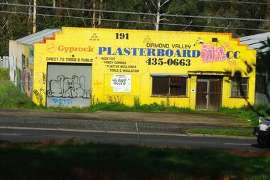
Photograph - Digital image, Marilyn Smith, Diamond Valley Plasterboard Factory at 191 Para Road Montmorency, 17/09/2014
... 2014 (now demolished) in Para Road. diamond valley plasterboard ...Diamond Valley Plasterboard factory 2014 (now demolished) in Para Road.Digital copy of colour photographdiamond valley plasterboard, para road greensborough -
 Greensborough Historical Society
Business card - Digital Image, Plenty Valley Printing Greensborough, 2016_
... Greensborough Historical Society 34A Glenauburn Road Lower ...Plenty Valley Printing is a Greensborough graphic design and printing business.Coloured business cardplenty valley printing, para road greensborough -
 Whitehorse Historical Society Inc.
Document, Full steam for Eastlink
... Mullum Mullum Valley Deep Creek Road Mitcham Eastern Freeway ...Work continuing on Mullum Mullum Valley tunnels and Ringwood bypass and Maroondah Highway bridge (photos).Work continuing on Mullum Mullum Valley tunnels and Ringwood bypass and Maroondah Highway bridge (photos).Work continuing on Mullum Mullum Valley tunnels and Ringwood bypass and Maroondah Highway bridge (photos).eastlink, ringwood bypass, maroondah highway, mullum mullum valley, deep creek road, mitcham, eastern freeway extension, tunnels -
 Kiewa Valley Historical Society
Set of 6 framed photographs - Kiewa Hydro Electric Scheme
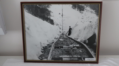
... - July 1943 6. Upper Kiewa Valley Road 3 to 4 Mile - Mt Arthur... of Junction Dam - July 1943 6. Upper Kiewa Valley Road 3 to 4 Mile ...Official photo of KHES constructed by SECVOfficial photo of KHES in the Kiewa Valley1. No. 1 Pipeline - from Anchor 1 to Anchor 5. August 1955 2. Junction Dam - General View from Downstream - May 1943 3. No. 3 Power Station - Clover Flat Camp - February 1951 4. Clover Dam - October 1954 5. View from Downstream of Junction Dam - July 1943 6. Upper Kiewa Valley Road 3 to 4 Mile - Mt Arthur in Background - July 1954 khes, secv -
 Ringwood and District Historical Society
Document - Subdivision Map, Part of Crown Sections 18, 19, 24 & 25, Parish of Warrandyte, County of Evelyn, Vol 5228 Fol 472 - 1926. (Park Orchards, Victoria)
... Map includes Valley Road, Granard Avenue, Park Road...Map includes Valley Road, Granard Avenue, Park Road ...A3 and A4 sized photocopies showing map section of land title showing streets, easements and allotment numbers, some with handwritten names and pricing notations circa mid 1950s.Map includes Valley Road, Granard Avenue, Park Road, Arundel Avenue, Hylton Avenue, Aviemore Avenue, Bowmore Avenue, Hopetoun Road, Colin Avenue, Daintree Avenue, Brucedale Crescent, Feversham Avenue, Ennismore Crescent, Iona Grove, Elgin Crescent and Gosford Crescent, Park Orchards, Victoria. -
 Bendigo Historical Society Inc.
Newspaper - JENNY FOLEY COLLECTION: HARD YAKKA
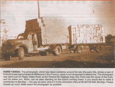
... Valley Road, at the Victoria Hill Diggings area. Eric Finch... was taken just off Happy Valley Road, at the Victoria Hill Diggings ...Bendigo Advertiser "The way we were" from Saturday, January 29, 2005. Hard yakka: this photograph, which was taken sometime around the late 40s early 50s, shows a load of finished boxes being loaded at Williamson's box factory, ready to be transported to Melbourne. the photograph was taken just off Happy Valley Road, at the Victoria Hill Diggings area. Eric Finch was the owner of the truck and his eldest son, Kevin, can be seen standing on the truck's running board. The clip is in a folder.newspaper, bendigo advertiser, the way we were -
 Falls Creek Historical Society
Document - S.E.C. - Falls Creek Tourist Hotel Project (Adjacent To Ski Village)
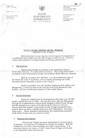
... was up to 2 1/2 acres adjacent to the Upper Kiewa Valley Road... for development was up to 2 1/2 acres adjacent to the Upper Kiewa Valley ...Bob (Herman) Hymans (a former member of the Royal Netherlands Navy) was born in Bloemendaal, Holland on 30th September 1922. During World War II he fought against the Japanese in the Dutch East Indies (now Indonesia) and was imprisoned in Changi and on the Burma Railway. After gaining qualifications as a Ski Instructor, Bob arrived in Falls Creek in July 1950. Working as an Instructor and Supervisor at Bogong Lodge, Bob decided his future was in accommodation. He was successful in negotiating an indenture for land from the State Electricity Commission (SEC). It took Bob two years to build his Grand Coeur Chalet but, tragically, it was burned down in August 1961. Bob also built the first Chairlift in Australia. This was a single chairlift and the structure was built from wooden electricity poles. He was constantly full of new ideas and proposals for the village. Bob Hymans died on 7th July 2007. This Collection of documents and letters tells the story of Bob's endeavours to develop Falls Creek into the ski village it is today.This item is significant because it documents plans made by the State Electricity Commission to develop the Falls Creek Tourist Area.A letter from the State Electricity Commission (SEC) outlining details of a site available for the development of a Tourist Hotel Project in Falls Creek in late 1962/3. The SEC estimated that by the winter of 1963 Falls Creek Village would be able to accommodate 500 persons. The site for development was up to 2 1/2 acres adjacent to the Upper Kiewa Valley Road. It envisaged a building able to accommodate about 100 guests. The successful developer would be granted a lease for 45 years at a rent of £300 per annum. Written applications for the lease were to be submitted by 31st March 1963.falls creek tourist area management committee, falls creek administration, state electricity commission -
 Halls Gap & Grampians Historical Society
Photograph
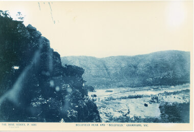
... A rocky outcrop on far left of photo. a cleared valley... on far left of photo. a cleared valley with buildings and roads ...Photo is of Fyans Valley with Hotel Bellfield in the valley. Photo is taken from Bellfield Peak. c1940sA rocky outcrop on far left of photo. a cleared valley with buildings and roads in foreground, flanked by a mountain range.THE ROSE SERIES. P 1695 BELLFIELD PEAK AND "BELLFIELD," GRAMPIANS, VIC scenery, fyans valley -
 Bendigo Historical Society Inc.
Document - ALBERT RICHARDSON COLLECTION: VICTORIA HILL IRONBARK
... residences on Happy Valley Road, and also set up a 30 head battery... Rae built two fine residences on Happy Valley Road, and also ...Three page handwritten document outlining the history of the Victoria Hill area. The open cuts on Victoria Hill; Lansell's Big 180 Mine, Victoria Quartz Mine; Wittscheibe's 'Jewellers Shop', Luffman and Sterry, Central Nell Gwynne and New Chum Hill are mentioned in the article. A description of the suitability of the Victoria Hill site as a potential mining museum is discussed as 'it is centrla to both the northern and southern ends of the main portion of the Bendigo and Eaglehawk mines'. William Rae built two fine residences on Happy Valley Road, and also set up a 30 head battery out of his gains from Victoria Hill.bendigo, mining, victoria hill -
 Falls Creek Historical Society
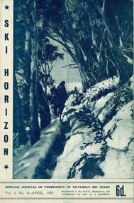
Journal - Ski-Horizon Vol 3 No 8
... the the Commission proposes to keep the Upper Kiewa Valley Road clear of snow... Kiewa Valley Road clear of snow as far as the Howman Dam Hostel ...Ski-Horizon is the official journal of the Federation of Victorian Ski Clubs which began publication in 1949. The were 26 original member clubs which included Albury Ski Club, Bogong Ski Club, Myrtleford Ski Club, Tallangatta and District Ski Club and Wangaratta Ski Club. Two pioneers of Falls Creek, Tom Mitchell, M.L.A., and Martin Romuld were Vice-Presidents of the Federation.This Journal is significant because it documents the early development of skiing in Victoria.The journal features stories and events chronicling developments in Victoria and internationally. Items related to the Falls Creek Area in this publication include:- Page 3 Beechworth and Dawn Ski Clubs are making good progress with their lodges. Dawn is next to Toni St. Elmo Page 4 Albury Ski Club has increased its membership from 140 to 180. It now has its own transport bus known as "Jackson" Page 17 A letter from H. H. C. Williams stating the the Commission proposes to keep the Upper Kiewa Valley Road clear of snow as far as the Howman Dam Hostel only.albury ski club, beechworth ski club, dawn lodge, h. h. c. williams -
 Bendigo Historical Society Inc.
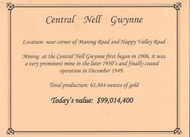
Document - ALBERT RICHARDSON COLLECTION: CENTRAL NELL GWYNNE MINE
... Nell Gwynne gold mine was located off Happy Valley Road, first... was located off Happy Valley Road, first turn to the left from Marong ...Two-page typed document plus location map. The Central Nell Gwynne gold mine was located off Happy Valley Road, first turn to the left from Marong Road, and up on the hill. The shaft depth was 1,912 ft. The original plant had small wooden poppet legs and a steam winch which were replaced, in 1935/36 by steel poppet legs obtained from the Virginia mine at Eaglehawk. Features and history of the plant are described including the winding engine, air compressor, boilers, and crushing battery. The dividends and gold production figures are given. The total yield of gold was 61,884 oz.bendigo, mining, central nell gwynne -
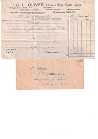 Whitehorse Historical Society Inc.
Financial record - Receipt, 25 Ti Tree Grove Rental Receipt, 30 June 1946
... information of other rentals: Corless - Wattle Valley Road, Mitcham... - Wattle Valley Road, Mitcham. 2 weeks = 3 shillings Bates, Jim ...Rental receipt for Mrs Schwerkolt's house at 25 Ti Tree Grove, ParkdaleReceipt (30 June 1946) issued to Mrs F Schwerkolt from G L Oliver. Real Estate Agent, 232 Como Parade, Parkdale, for 4 weeks rental by Knott for 25 Ti Tree Grove, Parkdale, which was the holiday home of Francesca Schwerkolt called " Mitcham". Record includes an envelope addressed to Mrs Hogan, Mrs Schwerkolt's daughter.Rental receipt for Mrs Schwerkolt's house at 25 Ti Tree Grove, Parkdaleschwerkolt. francesca, eriksson pearl eileen, hogan frances dora -
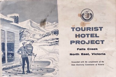 Falls Creek Historical Society
Document - Tourist Hotel Project
... to the Upper Kiewa Valley Road. It envisaged a building able... Kiewa Valley Road. It envisaged a building able to accommodate ...State Electricity Commission (SEC) outlined details of a site available for the development of a Tourist Hotel Project in Falls Creek in late 1962/3. SEC estimated that by the winter of 1963 Falls Creek Village would be able to accommodate 500 persons. The site for development was up to 2½ acres adjacent to the Upper Kiewa Valley Road. It envisaged a building able to accommodate about 100 guests. The successful developer would be granted a lease for 45 years at a rent of £300 per annum. Written applications for the lease were to be submitted by 31st March 1963.This item is significant because it documents plans made by the State Electricity Commission to develop the Falls Creek Tourist Area. A folder with a black and white image of skiers outside a hotel on the left. The logo of the State Electricity Commission and text is on the right half of the folder.On right half of cover: Logo of the State Electricity Commission TOURIST HOTEL PROJECT Falls Creek / North East Victoria Forwarded with the compliments of the State Electricity Commission of Victoriafalls creek tourist area, hotel development falls creek, falls creek projects 1963 -
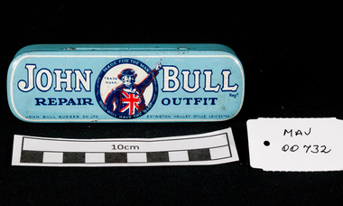 City of Moorabbin Historical Society (Operating the Box Cottage Museum)
Containers, tin 'John Bull' Tyre Repair, mid 20thC
... to manufacture its own bicycle and pram tyres at its Evington Valley Road... bicycle and pram tyres at its Evington Valley Road site ...John Cecil Burton and his brother Cecil Hubert formed The Leicester Rubber Company in 1906, to sell imported cycle tyres. The Company's patriotic 'John Bull' trade mark came into force a few years later in 1908. In 1915 the Rubber Company started to manufacture its own bicycle and pram tyres at its Evington Valley Road site in Leicester, and in 1928 they started to mass produce car and motorcycle tyres at the site. The name was changed to the John Bull Rubber Company in 1934, and in 1937 an associated company was formed to manufacture rubber to metal components - Metalastic. In 1955 the John Bull group companies merged, and in 1958 the company became part of the Dunlop Rubber Company.An empty blue tin with a hinged lid for 'John Bull' Tyre repair outfitLid top ; JOHN BULL Reg. T / REPAIR OUTFIT/John Bull Rubber Co. Ltd. Evington, Valley Mills, Leicester Trade Mark ;Central Photo of 'John Bull' encased in a circle around is written ' Made for the Man who will have the Best' / TRADE / MARK Lid Inside ; INSTRUCTIONS FOR REPAIRING PUNCTURES/ ................ Base ; RIDE / JOHN BULL TYRES / and you will have practically no use for this OUTFIT* tyres, rubber, bicycles, cars, prams, leicester, england, john bull rubber company, burton john c , hubert cecil, leicester rubber company, dunlop rubber pty ltd, -
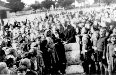 Surrey Hills Historical Society Collection
Photograph - Retirement of Mr John Clough as Head Teacher of Surrey Hills Primary School, 1948
... Wattle Valley Road, Camberwell. At Surrey Hills he was succeeded... - living Wattle Valley Road, Camberwell. At Surrey Hills he ...John Spencer Clough was the Head Teacher at Surrey Hills during the Depression and the Second World War years. He had a long history in the education department. He was born in Eaglehawk in 1889; married Lily Carpenter in 1915 and died in Camberwell in 1952. He served in France during the First World War. He enlisted in 1915 (SERN 5671) aged 26; occupation school teacher. Electoral rolls place him at the following places as a school teacher: 1912 - Sea View, Warragul 1913 - Leongatha 1914, 1915, 1916 - Carpendeit 1919 - Portland 1922 - Scarsdale 1925, 1926 - Werribee 1928 - Echuca 1931 - Ballarat 1935 - living Wattle Valley Road, Camberwell. At Surrey Hills he was succeeded by Mr Lewis Wheeler. The girl presenting Mr Clough with his retirement gift was Margaret Haines who made the presentation on behalf of the students. A B&W photo of an elderly gentleman surrounded by children. He is wearing a suit and tie and a girl is presenting him with what looks to be a radio. There is a chair with floral covering central to the photo and the gentleman is standing behind it. The background is consistent with a school playground.Number in pencil on the rear - SH1150surrey hills state school, surrey hills primary school, margaret haines, margaret dowsett, john clough, john spencer clough, education, schools -
 Halls Gap & Grampians Historical Society
Photograph
... Photo depicts Fyans Valley. The road is The Grampians... Valley. The road is The Grampians/ Dunkeld Road, leading ...Photo depicts Fyans Valley. The road is The Grampians/ Dunkeld Road, leading to Dunkeld towards the right or Halls Gap travelling towards the left. Fyans Creek is visible in parts at the foot of the range (middle of Photo). Photo appears to have been taken from Bellfield Pk area. Photo is typical of those taken by Forests Commission of Victoria in the 1960sPhoto shows a mountain range in the background with a valley. The Valley has a band of a mostly cleared grassy section (middle of photo) with a fairly dense treed area in the foreground. A road and some buildings can be seen where the cleared land meets the treed area.scenery, fyans valley -
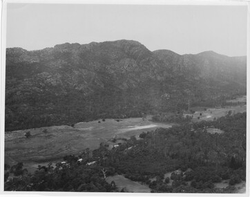
 Bendigo Historical Society Inc.
Document - CENTRAL NELL GWYNNE GOLD MINE
... the corner of Marong Road and Happy Valley Road. Opened in 1906... Valley Road. Opened in 1906, ceased operation in December 1949 ...Interpretive sign and 4 photos Central Nell Gwynne Gold Mine, used in display. Central Nell Gwynne was located near the corner of Marong Road and Happy Valley Road. Opened in 1906, ceased operation in December 1949. Total production: 61,884 ounces of Gold. Today's Value: $99,014,400. Photos: a. Colour photo, concrete footings at mine site, April 2012. b. Colour photo, Central Nell Gwynne poppet head, April 2012.Poppet head painted white with red trim. Concrete footings in foreround. c. Central Nell Gwynne mine site 1930's. Poppet head and engine room sheds on LH side, trestle way to primary crusher and crushing battery. Tailing dam in immediate foreground. on RH side. Sand heaps in middle foreground. d. Central Nell Gwynne Mine 1930. Underground view, men holding carbide lamps working at 265 level in mine. Large quartz spur formation visible in foreground.bendigo, mining, central nell gwynne -
 Bendigo Historical Society Inc.
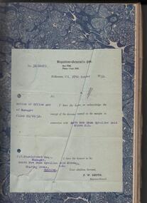
Administrative record - South New Chum Syncline Gold Mines N.L. Minute Book, 1932 - 1940
... in 'Happy Valley Road, Bendigo for the sum of not less than Two... and mine equipment in 'Happy Valley Road, Bendigo for the sum ...South New Chum Syncline South New Chum Syncline Gold Mines, N.L., has been floated with a capital of £27,500 in 55,000 shares of 10/ each. Forty thousand have been issued at 1/,10,000 fully paid shares go to vendors, and 5000 will be held in reserve. - Messrs. Savage and Nicholas report that the issue was heavily over-subscribed. The property is situated in the central portion of the Bendigo field, adjoining such former producers as the Victoria Quartz. Lansell’s Big 180, North Old Chum and New Chum. (Bendigo Advertiser, 29th September 1932).Green hard cover book, maroon binding on spine, 284 pages of which 94 are used. 'Minute Book' on front cover. Written in pencil across top of name ' South New Chum Syncline'. Inside front cover affixed to page, document 'Registrar-General re Notice of Office and of Manager, filed 23.10.32 in connection with South New Chum Syncline Gold Mines N.L. Minutes in book date from 5th October 1932 to 23rd August 1935. First minutes of meeting describes the Company as having 55,000 shares of ten shillings each. Final two pages have documents affixed that relate to the closure and sell-off of the free-hold property and mine equipment in 'Happy Valley Road, Bendigo for the sum of not less than Two Hundred and fifty pounds and that out of the proceeds thereof the following amounts be paid', An amount of 120 pounds, thirteen shillings and two pence are listed. Minute Book is part of the Margaret Roberts Collection. bendigo, gold mining, south new chum syncline gold mine, j.j. stanistreet, legal manager, margaret roberts collection, -
 Surrey Hills Historical Society Collection
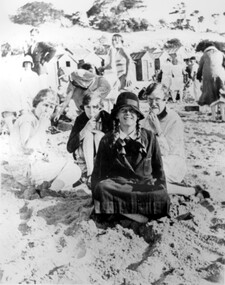
Photograph, Stalker family beach picnic, 1930s
... , an accountant, lived in Wattle Valley Road, Canterbury in 1910. From... Alexander, an accountant, lived in Wattle Valley Road, Canterbury ...Associated with the Stalker family of Surrey Hills. Betty Neil Smith (Stalker) was born in 1919 in Balwyn (Surrey Hills). She was one of 4 daughters of Alexander MacLaren Stalker (1885-1970/1973) and Charlotte Eleanor Hayward (1884-1953) who were married in 1911. Her sisters were Ruth McLaren Stalker (1913, Surrey Hills), Joan Winnock Stalker (1917, Surrey Hills) and Beatrice Mary Stalker(1919). Their mother Charlotte Hayward was a teacher prior to her marriage. Their father Alexander, an accountant, lived in Wattle Valley Road, Canterbury in 1910. From 1912-1931 they are listed at ‘Benwerrin’, (44) Wandsworth Road, Surrey Hills. This was later the home of Beatrice Mary and Howard Everard. Betty, Ruth and Joan later lived at 9/48 Wandsworth Road. it is assumed that the photo is of the Stalker girls and given their parents' later residence at Brighton, this may have been taken at Brighton beach. This photo documents part of the social history of a family with a long and strong association with Surrey Hills. The backdrop of the typical bathing boxes used for changing into swimsuits, for lunch and for storing sports and beach gear, documents beach recreation and culture of the 1930s. For many years in the late nineteenth century, Brighton was Melbourne's favourite seaside destination. The now iconic bathing boxes were a response to Victorian ideas of morality and sea bathing. There are 82 Brighton bathing boxes, which protected by a heritage overlay because of their uniform scale and proportion, building materials, sentry order alignment. All retain their classic Victorian architectural features with timber framing, weatherboards and corrugated iron roofs. They remain as they did over one hundred years ago, as licensed bathing boxes. Service amenities such as electricity or water were never connected.A black and white photograph of many people enjoying the beach. There are bathing boxes in the background and some ti-tree beyond that.uniforms, clothing and dress, bathing boxes, stalker family -
 Wodonga & District Historical Society Inc
Functional object - Bicycle Tool and Repair Kit, c1935
... , a new factory was built in Evington Valley Road as indicated..., a new factory was built in Evington Valley Road as indicated ...The first bicycles arrived in Australia in the 1860s. They gradually gained in popularity and by the 1890s they offered a cheap and relatively comfortable mode of transport. Far being just a means of leisure, long distance cycle travelling became a fact of life in rural areas for people such as sheep shearers and other agricultural labourers with migratory work. The bicycle and swag travelled much of Australia on dusty dirt tracks, long before the automobile was introduced. Today the bicycle continues to be an important item for general, cheap transport, sport and leisure. Tool kits such as those shown in the item, were and important piece of equipment for bicycle enthusiasts, particularly on a longer ride where assistance may not be close by if the rider experienced a punctured tyre. John Bull Rubber Co. Ltd. was a British tyre manufacturer based in Leicester. It was established in 1906 and was originally named Leicester Rubber Company. In 1915, a new factory was built in Evington Valley Road as indicated on the repair outfit tin in this kit. It was renamed John Bull Rubber in 1934 after its popular product of the same name. In 1958, the company was acquired by Dunlop Rubber. A leather bag containing tools and 2 tins containing rubber patches to repair bicycle tyres. The bag has 2 straps and metal buckles to attach it to the back of the bicycle seat.On tin 1: "The John Bull / Repair Outfit/ John Bull Rubber Co. Ltd./ Evington Valley Mills, Leicester" On tin 2: "ZENITH Repair Outfit / For Cycle and Rubber Repairs/ Self Vulcanizing" On tin 3: Around the DUNLOP logo "Six Self Lighting/ Patch Heat Units / For Cycle Tube/ Vulcaniser"bicycle history, bicycle repairs, john bull rubber, cycling leisure -
Greensborough Historical Society
Newsletter, Greenhills and North Greensborough Progress Association, Community News: official journal of the Greenhills and Nth. Greensborough Progress Association and the Apollo Parkways Progress Association. December 1979, 12/1979
... Valley Council, Diamond Creek road... what next??, Chain-sore... Valley Council, Diamond Creek road... what next??, Chain-sore ...G.A.G.P.A. alive and well, The F5/F18 freeway and Diamond Valley Council, Diamond Creek road... what next??, Chain-sore reaction!!, Kinder news, Diamond Valley Repertory.Newsletter, 4 p.greenhills and north greensborough progress association, greenhills, apollo parkways progress association, apollo parkways -
 Kiewa Valley Historical Society
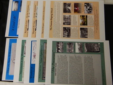
Posters - 10 in the Set, The Famous Bogong School; Beyond the Gate - (up and down); A Good Life; The Precursors; Great Expectations; Windows to Yesterday; Movement in the Mountains; Life wasn't meant to be Easy; There are Places I'll Remember, 1998
... . The Kiewa Valley Runs 8. Roads constructed 9. The 1930's 10. Pre.... The Kiewa Valley Runs 8. Roads constructed 9. The 1930's 10. Pre ...These posters were produced or a display during the Mt Beauty Music Festival in 1998. They cover the history of the Kiewa Valley from the early days, farming and the Kiewa Hydro Electric Scheme.These posters summarise the history of the Kiewa Valley and were compiled using publications, memories and documents. The posters are clear and useful for displaySee KVHS 0164 A4 glossy cardboard posters: Beige, Blue or Green with photos and writing of the history of different aspects of the Kiewa Valley. 1. Bogong 2. Mt Beauty 3. Bogong 4. The Early Days 5. The Early Years 6. The Kiewa Hydro Story 7. The Kiewa Valley Runs 8. Roads constructed 9. The 1930's 10. Pre 1930bogong state school; bogong village; secv; khes; tawonga; surveyors; mt beauty; camps; kiewa valley