Showing 2474 items
matching victoria - maps
-
 Bendigo Historical Society Inc.
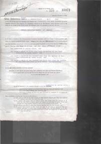
Document - MCCOLL, RANKIN AND STANISTREET COLLECTION: GOLD MINING LEASE RONALD ALEXANDER RANKIN, 1941
... of Victoria. 3 pages with map - lease adjoins Bellevue Road. Lease... Alexander Rankin of Bendigo and the State of Victoria. 3 pages ...Document: McColl, Rankin and Stanistreet: lease document between Ronald Alexander Rankin of Bendigo and the State of Victoria. 3 pages with map - lease adjoins Bellevue Road. Lease transferred to Deborah Gold Mines NL in 1945.organization, mining, gold mining lease, mccoll, rankin and stanistreet:, ronald alexander rankin, lease document, gold mining -
 Tatura Irrigation & Wartime Camps Museum
Book, The Tatura Secret Radio, 1997
... . The front cover depicts a man with headphones on. A map of Victoria... with headphones on. A map of Victoria and short history of the book ...Army Intelligence knew there was a secret radio operating in Tatura No.1 Camp. The inmates were getting the war news direct from Germany. They had to have a strong shortwave receiver, but where was it?White soft cover book with an entrance made with barb wire. The front cover depicts a man with headphones on. A map of Victoria and short history of the book on the back cover. B/W photos, with a map of Tatura No 1 camp.Reg. No. 1870.1 signed "With Best Wishes Laura Nilsen"the tatura secret radio, nilsen h, nilsen l, glover i, camp 1, tatura, ww2 camp 1, books, history, local -
Lakes Entrance Regional Historical Society (operating as Lakes Entrance History Centre & Museum)
Book, Da Costa, Grant, Car Touring and Bush Walking in East Gippsland, 1988
... areas of East Gippsland, Victoria, including twenty seven maps... Gippsland, Victoria, including twenty seven maps and notes ...Comprehensive guide to the magnificent forests and coastal areas of East Gippsland, Victoria, including twenty seven maps and notes on seventeen car tours, fifty nine locations of outstanding impact and 45 bushwalks. Illustrated with coloured photographicnatural history, vegetation, coast -
Glenelg Shire Council Cultural Collection
Souvenir - Drink Coasters, n.d
... , 'PORTLAND DEVELOPMENT COMMITTEE', map of Victoria, green and purple... COMMITTEE', map of Victoria, green and purple 'Prosper in Portland ...2 x Round, white cardboard coasters. Black line border, 'PORTLAND DEVELOPMENT COMMITTEE', map of Victoria, green and purple 'Prosper in Portland' overlaid. Identification Numbers 6349, 6349 a Measures each 9.3 cm diameter -
 Federation University Historical Collection
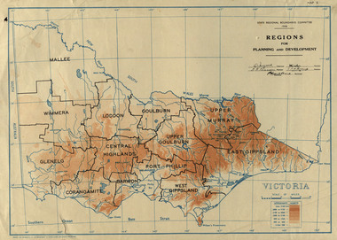
Map, Victoria: Regions for Planning and Development, 1944, 1944
... Two colour map of Victoria showing the regions for planning... port phillip victoria m4486 Two colour map of Victoria showing ...This map was produced for the State Regional Boundaries Committee Two colour map of Victoria showing the regions for planning and development. The regions are Central Highlands, Mallee, Wimmera, Glenelg, Corangamite, Barwon, Loddon, Goulburn, Upper Goulburn, Upper Murray, East Gippsland, West Gippsland, Port Phillip.central highlands, mallee, wimmera, glenelg, corangamite, barwon, loddon, goulburn, upper goulburn, upper murray, east gippsland, west gippsland, port phillip, victoria, m4486 -
 University of Melbourne, Burnley Campus Archives
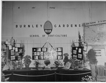
Photograph - Black and white print, Royal Show 1957, 1957
... information and a map of Victoria locating institutes offering rural..., horticultural information and a map of Victoria locating institutes ...Note by T.H. Kneen 13 May1992, "The Burnley display was part of the Division of Agricultural Education's display covering Dookie, Longerenong and Burnley. Reference to Rural Training in 1957 would have been mainly to the on-farm training phase of the Rural Reconstruction Training Scheme. The Agricultural Collegians Association members had a meeting point at the exhibit. Burnley ex-students were not members of that association."Black and white photograph. Display mounted by Burnley Gardens School of Horticulture at the Royal Agricultural Show 1957. Incorporates photographs of College activities, horticultural information and a map of Victoria locating institutes offering rural training to ex-servicemen.On reverse, "Royal Show 1957."burnley gardens, school of horticulture, royal agricultural show, dookie college, rural training, rural reconstruction training scheme, the agricultural collegians association, horticulture, publicity, dept of agriculture education division, longerenong college -
 Bendigo Historical Society Inc.
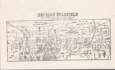
Map - BENDIGO GOLDFIELD MAP
... . of Mines, Victoria printed on the map. Shows reefs from Bird's... are shown. Dept. of Mines, Victoria printed on the map. Shows reefs ...Two not very clear copies of the Bendigo Goldfield Map. Streets, Railway Line, Lines of Reefs and mines are shown. Dept. of Mines, Victoria printed on the map. Shows reefs from Bird's Line of Reefs to Lightning Hill Line of Reef.map, bendigo, goldfields, bendigo goldfield map, lines of reefs, dept. of mines victoria -
 Melbourne Tram Museum
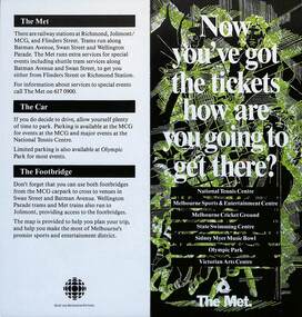
Pamphlet, The Met, "Now you've got the tickets how are you going to get there?", mid 1990s
... and Recreation Victoria with a map of the major sporting venues... there?" published jointly by The Met and Sport and Recreation Victoria ...Pamphlet "Now you've got the tickets how are you going to get there?" published jointly by The Met and Sport and Recreation Victoria with a map of the major sporting venues in the city area and the Victorian Arts Centre. Published before the diversion of the Batman Ave tram line via Flinders St. Gives tips on parking, train/tram travel, and the MCG footbridge. The line was diverted via Flinders St on 6/6/1999 - see reference. yields information about the travelling to the major Melbourne sports venues.Pamphlet - 2 fold DL printed in colour with map.trams, tramways, the met, sporting venues, public transport, maps, batman ave, batman avenue -
Glenelg Shire Council Cultural Collection
Souvenir - Limited Editions First Day Covers - Historic Shipwrecks - Admella 150 2009, 2009
... , with map Southern Victoria. 50 cents Admella Stamp not cancelled... cover. Both coloured envelope, with map Southern Victoria. 50 ...Limited edition first day cover. Both coloured envelope, with map Southern Victoria. 50 cents Admella Stamp not cancelled. 'Admella 150th Logo, 'Historic Shipwrecks' on front. back, short history of shipwrecks, Admella Lock Ard, Dunbar. -
 St Kilda Historical Society
Photograph - Photo map, 28/01/1951
... with a current map, and access to other historical photo maps of Victoria... maps of Victoria, see the Historic Photo-Maps Index published ...One of a series of photo-maps produced for the Department of Crown Lands and Survey (1857-1983). For correlation with a current map, and access to other historical photo maps of Victoria, see the Historic Photo-Maps Index published by the Department of Environment, Land, Water and Planning at https://services.land.vic.gov.au/DELWPmaps/historical-photomaps/Black and white aerial photograph1424-45 SECRET 534 Run 18 Lens 12" Melbourne Metropolitan 12150 28.1.51 M639albert park, st kilda junction, st kilda pier, catani gardens, st kilda, prahran, albert park lake, 1951, middle park, st kilda beach, windsor -
 St Kilda Historical Society
Photograph - Photo map, 17/01/1951
... with a current map, and access to other historical photo maps of Victoria... maps of Victoria, see the Historic Photo-Maps Index published ...One of a series of photo-maps produced for the Department of Crown Lands and Survey (1857-1983). For correlation with a current map, and access to other historical photo maps of Victoria, see the Historic Photo-Maps Index published by the Department of Environment, Land, Water and Planning at https://services.land.vic.gov.au/DELWPmaps/historical-photomaps/Black and white aerial photograph1414-21 538 Run 19 Lens 12" Melbourne Metropolitan 12150 17.1.51 M586st kilda, st kilda botanical gardens, peanut farm, elwood, 1951, point ormond, elwood canal, st kilda beach -
 St Kilda Historical Society
Photograph - Photo map, 28/01/1951
... with a current map, and access to other historical photo maps of Victoria... maps of Victoria, see the Historic Photo-Maps Index published ...One of a series of photo-maps produced for the Department of Crown Lands and Survey (1857-1983). For correlation with a current map, and access to other historical photo maps of Victoria, see the Historic Photo-Maps Index published by the Department of Environment, Land, Water and Planning at https://services.land.vic.gov.au/DELWPmaps/historical-photomaps/Black and white aerial photograph1424-118 534 Run 20 Lens 12" Melbourne Metropolitan 12150 18.1.51M639elwood, point ormond, elwood park, elsternwick park, elwood beach, 1951 -
 St Kilda Historical Society
Photograph - Photo map, 17/01/1951
... with a current map, and access to other historical photo maps of Victoria... maps of Victoria, see the Historic Photo-Maps Index published ...One of a series of photo-maps produced for the Department of Crown Lands and Survey (1857-1983). For correlation with a current map, and access to other historical photo maps of Victoria, see the Historic Photo-Maps Index published by the Department of Environment, Land, Water and Planning at https://services.land.vic.gov.au/DELWPmaps/historical-photomaps/Black and white aerial photograph1414-20 538 Run 19 Lens 12" Melbourne Metropolitan 12150 17.1.51 M586elwood, elsternwick, st kilda east, balaclava, ripponlea, 1951 -
 St Kilda Historical Society
Photograph - Photo map, 28/01/1951
... with a current map, and access to other historical photo maps of Victoria... maps of Victoria, see the Historic Photo-Maps Index published ...One of a series of photo-maps produced for the Department of Crown Lands and Survey (1857-1983). For correlation with a current map, and access to other historical photo maps of Victoria, see the Historic Photo-Maps Index published by the Department of Environment, Land, Water and Planning at https://services.land.vic.gov.au/DELWPmaps/historical-photomaps/Black and white aerial photograph1424-44 534 Run 18 Lens 12" Melbourne Metropolitan 12150 28.1.51 M639 -
 St Kilda Historical Society
Photograph - Photo map, 28/01/1951
... with a current map, and access to other historical photo maps of Victoria... maps of Victoria, see the Historic Photo-Maps Index published ...One of a series of photo-maps produced for the Department of Crown Lands and Survey (1857-1983). For correlation with a current map, and access to other historical photo maps of Victoria, see the Historic Photo-Maps Index published by the Department of Environment, Land, Water and Planning at https://services.land.vic.gov.au/DELWPmaps/historical-photomaps/Black and white aerial photograph1424-43 534 Run 18 Lens 12" Melbourne Metropolitan 12150 28.1.51 M639armadale, malvern, st kilda cemetery, caulfield north, st kilda east, 1951 -
 St Kilda Historical Society
Photograph - Photo map, 30/01/1960
... with a current map, and access to other historical photo maps of Victoria... maps of Victoria, see the Historic Photo-Maps Index published ...One of a series of photo-maps produced for the Department of Crown Lands and Survey (1857-1983). For correlation with a current map, and access to other historical photo maps of Victoria, see the Historic Photo-Maps Index published by the Department of Environment, Land, Water and Planning at https://services.land.vic.gov.au/DELWPmaps/historical-photomaps/Black and white aerial photographVic 1093-62 Melbourne & Metropolitan Project Run 21 30.1.60 Lens 10" 8.200middle park, albert park, catani gardens, st kilda west, 1960 -
 St Kilda Historical Society
Photograph - Photo map, 30/01/1960
... with a current map, and access to other historical photo maps of Victoria... maps of Victoria, see the Historic Photo-Maps Index published ...One of a series of photo-maps produced for the Department of Crown Lands and Survey (1857-1983). For correlation with a current map, and access to other historical photo maps of Victoria, see the Historic Photo-Maps Index published by the Department of Environment, Land, Water and Planning at https://services.land.vic.gov.au/DELWPmaps/historical-photomaps/Black and white aerial photographVic 1093-60 Melbourne & Metropolitan Project Run 21 30.1.60 Lens 10" 8.200st kilda, albert park, prahran, windsor, south yarra, 1960 -
 St Kilda Historical Society
Photograph - Photo map, 30/01/1960
... with a current map, and access to other historical photo maps of Victoria... maps of Victoria, see the Historic Photo-Maps Index published ...One of a series of photo-maps produced for the Department of Crown Lands and Survey (1857-1983). For correlation with a current map, and access to other historical photo maps of Victoria, see the Historic Photo-Maps Index published by the Department of Environment, Land, Water and Planning at https://services.land.vic.gov.au/DELWPmaps/historical-photomaps/Black and white aerial photographVic 1092-36 Melbourne & Metropolitan Project Run 22 30.1.60 Lens 10" 8.200st kilda, st kilda pier, st kilda beach, catani gardens, 1960 -
 St Kilda Historical Society
Photograph - Photo map, 30/01/1960
... with a current map, and access to other historical photo maps of Victoria... maps of Victoria, see the Historic Photo-Maps Index published ...One of a series of photo-maps produced for the Department of Crown Lands and Survey (1857-1983). For correlation with a current map, and access to other historical photo maps of Victoria, see the Historic Photo-Maps Index published by the Department of Environment, Land, Water and Planning at https://services.land.vic.gov.au/DELWPmaps/historical-photomaps/Black and white aerial photographVic 1092-38 Melbourne & Metropolitan Project Run 22 30.1.60 Lens 10" 8.200st kilda, st kilda beach, st kilda pier, catani gardens, 1960, st kilda botanical gardens, peanut farm -
 St Kilda Historical Society
Photograph - Photo map, 30/01/1960
... with a current map, and access to other historical photo maps of Victoria... maps of Victoria, see the Historic Photo-Maps Index published ...One of a series of photo-maps produced for the Department of Crown Lands and Survey (1857-1983). For correlation with a current map, and access to other historical photo maps of Victoria, see the Historic Photo-Maps Index published by the Department of Environment, Land, Water and Planning at https://services.land.vic.gov.au/DELWPmaps/historical-photomaps/Black and white aerial photographVic 1092-40 Melbourne & Metropolitan Project Run 22 30.1.60 Lens 10" 8.200st kilda east, balaclava, ripponlea, st kilda cemetery, 1960 -
 St Kilda Historical Society
Photograph - Photo map, 30/01/1960
... with a current map, and access to other historical photo maps of Victoria... maps of Victoria, see the Historic Photo-Maps Index published ...One of a series of photo-maps produced for the Department of Crown Lands and Survey (1857-1983). For correlation with a current map, and access to other historical photo maps of Victoria, see the Historic Photo-Maps Index published by the Department of Environment, Land, Water and Planning at https://services.land.vic.gov.au/DELWPmaps/historical-photomaps/Black and white aerial photographVic 1092-42 Melbourne & Metropolitan Project Run 22 30.1.60 Lens 10" 8.200malvern, caulfield, caulfield park, 1960 -
 St Kilda Historical Society
Photograph - Photo map, 30/01/1960
... with a current map, and access to other historical photo maps of Victoria... maps of Victoria, see the Historic Photo-Maps Index published ...One of a series of photo-maps produced for the Department of Crown Lands and Survey (1857-1983). For correlation with a current map, and access to other historical photo maps of Victoria, see the Historic Photo-Maps Index published by the Department of Environment, Land, Water and Planning at https://services.land.vic.gov.au/DELWPmaps/historical-photomaps/Black and white aerial photographVic 1091-112 Melbourne & Metropolitan Project Run 23East 30.1.1960 Lens 10" 8.200elwood, point ormond, elwood park, elwood canal, 1960 -
 St Kilda Historical Society
Photograph - Photo map, 30/01/1960
... with a current map, and access to other historical photo maps of Victoria... maps of Victoria, see the Historic Photo-Maps Index published ...One of a series of photo-maps produced for the Department of Crown Lands and Survey (1857-1983). For correlation with a current map, and access to other historical photo maps of Victoria, see the Historic Photo-Maps Index published by the Department of Environment, Land, Water and Planning at https://services.land.vic.gov.au/DELWPmaps/historical-photomaps/Black and white aerial photographVic 1091-110 Melbourne & Metropolitan Project Run 23East 30.1.60 Lens 10" 8.200elwood, elsternwick, elsternwick park, ripponlea, st kilda east, caulfield, balaclava, 1960 -
 St Kilda Historical Society
Photograph - Photo map, 30/01/1960
... with a current map, and access to other historical photo maps of Victoria... maps of Victoria, see the Historic Photo-Maps Index published ...One of a series of photo-maps produced for the Department of Crown Lands and Survey (1857-1983). For correlation with a current map, and access to other historical photo maps of Victoria, see the Historic Photo-Maps Index published by the Department of Environment, Land, Water and Planning at https://services.land.vic.gov.au/DELWPmaps/historical-photomaps/Black and white aerial photographVic 1091-1 Melbourne & Metropolitan Project Run 24East 30.1.60 Lens 10" 8.200elwood, elwood beach, elwood park, 1960 -
 St Kilda Historical Society
Photograph - Photo map, 30/01/1960
... with a current map, and access to other historical photo maps of Victoria... maps of Victoria, see the Historic Photo-Maps Index published ...One of a series of photo-maps produced for the Department of Crown Lands and Survey (1857-1983). For correlation with a current map, and access to other historical photo maps of Victoria, see the Historic Photo-Maps Index published by the Department of Environment, Land, Water and Planning at https://services.land.vic.gov.au/DELWPmaps/historical-photomaps/Black and white aerial photographVic 1091-2 Melbourne & Metropolitan Project Run 24East 30.1.60 Lens 10" 8.200elwood, elwood park, elwood beach, elsternwick park, 1960 -
 St Kilda Historical Society
Photograph - Photo map, 3/3/1964
... with a current map, and access to other historical photo maps of Victoria... maps of Victoria, see the Historic Photo-Maps Index published ...One of a series of photo-maps produced for the Department of Crown Lands and Survey (1857-1983). For correlation with a current map, and access to other historical photo maps of Victoria, see the Historic Photo-Maps Index published by the Department of Environment, Land, Water and Planning at https://services.land.vic.gov.au/DELWPmaps/historical-photomaps/Black and white aerial photographVic 1833 Melbourne 1963 Project Run 15 3.3.64 Lens 205 152.70 M/M 5.150 56prahran, fawkner park, south yarra, albert park, 1964 -
 St Kilda Historical Society
Photograph - Photo map, 14/12/1963
... with a current map, and access to other historical photo maps of Victoria... maps of Victoria, see the Historic Photo-Maps Index published ...One of a series of photo-maps produced for the Department of Crown Lands and Survey (1857-1983). For correlation with a current map, and access to other historical photo maps of Victoria, see the Historic Photo-Maps Index published by the Department of Environment, Land, Water and Planning at https://services.land.vic.gov.au/DELWPmaps/historical-photomaps/Black and white aerial photographVic 1807 Melbourne 1963 Project Run 16 14.12.63 Lens 205 152.70 M/M 5.150 179st kilda, prahran, albert park, st kilda east, balaclava, 1963 -
 St Kilda Historical Society
Photograph - Photo map, 14/12/1963
... with a current map, and access to other historical photo maps of Victoria... maps of Victoria, see the Historic Photo-Maps Index published ...One of a series of photo-maps produced for the Department of Crown Lands and Survey (1857-1983). For correlation with a current map, and access to other historical photo maps of Victoria, see the Historic Photo-Maps Index published by the Department of Environment, Land, Water and Planning at https://services.land.vic.gov.au/DELWPmaps/historical-photomaps/Black and white aerial photographVic 1807 Melbourne 1963 Project Run 16 14.12.63 Lens 205 152.70 M/M 5.150 181st kilda cemetery, caulfield north, st kilda east, armadale, malvern, 1963 -
 St Kilda Historical Society
Photograph - Photo map, 14/12/1963
... with a current map, and access to other historical photo maps of Victoria... maps of Victoria, see the Historic Photo-Maps Index published ...One of a series of photo-maps produced for the Department of Crown Lands and Survey (1857-1983). For correlation with a current map, and access to other historical photo maps of Victoria, see the Historic Photo-Maps Index published by the Department of Environment, Land, Water and Planning at https://services.land.vic.gov.au/DELWPmaps/historical-photomaps/Black and white aerial photographVic 1807 Melbourne 1963 Project Run 17 14.12.63 Lens 205 152,70 M/M 5.150 34st kilda, peanut farm, point ormond, st kilda marina, st kilda pier, 1963 -
 St Kilda Historical Society
Photograph - Photo map, 14/12/1963
... with a current map, and access to other historical photo maps of Victoria... maps of Victoria, see the Historic Photo-Maps Index published ...One of a series of photo-maps produced for the Department of Crown Lands and Survey (1857-1983). For correlation with a current map, and access to other historical photo maps of Victoria, see the Historic Photo-Maps Index published by the Department of Environment, Land, Water and Planning at https://services.land.vic.gov.au/DELWPmaps/historical-photomaps/Black and white aerial photographVic 1806 Melbourne 1964 Project Run 18 14.12.63 Lens 205 152.70 M/M 5.150 161elsternwick, elsternwick park, elwood, elwood canal, elwood beach, elwood park, 1963