Showing 2841 items
matching wests road
-
 Whitehorse Historical Society Inc.
Article, Shopping centre facelift, 1983
... A new building for the south-west corner of Whitehorse Road...-west corner of Whitehorse Road and Station Street Mitcham ...A new building for the south-west corner of Whitehorse Road and Station Street Mitcham.A new building for the south-west corner of Whitehorse Road and Station Street Mitcham. The upper floor offices are to be occupied by the legal firm, Mulcahy, Mendelson and Round. The site was originally that of the Hill Hotel.A new building for the south-west corner of Whitehorse Road and Station Street Mitcham. mitcham shopping centre, whitehorse road, mitcham, station street, mitcham, mendelson, roger, mulcahy, mendelson and round, hill hotel, mitcham -
 Wodonga & District Historical Society Inc
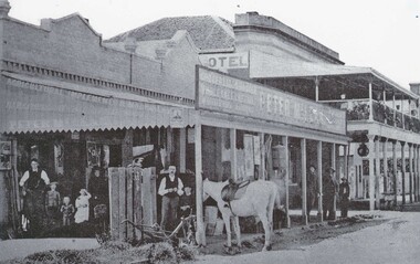
Photograph - Peter McLean's General Store and the Terminus Hotel, Wodonga, C. 1874
... . These buildings were on the west side of Sydney Road, later renamed... and Family Drapers General Store. These buildings were on the west ...The Terminus Hotel, Wodonga was built by James Thompson Hatch in 1873, the same year the railway reached Wodonga from Melbourne. It was named due to its close proximity to the railway terminus. It was sold to Messrs George Day and Kenneth McLennan of Albury. It was first licenced to J.G. Morton in January 1874. Annie Allen, from Ireland, took over as licensee of the hotel containing 14 rooms in 1879, after she and her husband, George James Allen, purchased it. In 1887 they added a new wing on the south boundary of the property next to Peter McLean’s store at 81 Sydney Road. The architects for the new wing were Gordon and Gordon. A billiard room, a dining room, and 18 other rooms were added on the vacant block of land between the Hotel and the Bank of Victoria. A balcony 6 feet wide was added on the north side. Included in the plans was the latest patent elevator, later known as a dumb waiter. Allen died in 1889 aged 52, and Annie Allen continued to run the Terminus. She later married John G. Haldon and was licensee of the hotel until December 1898 when the licence was transferred to William Carkeek. Carkeek, from Cornwall, arrived in the colony around 1860 and is considered one of the founders of Tallangatta. In November 1903, the license was transferred to Daniel Crawford, then in 1906 it was transferred to Mr Stephen Carkeek. In 1916 it passed into the hands of Mr H. W. Allen of Rutherglen, son of Mr George James Allen. Between 1916 and 1933 there were a variety of licensees. In October 1933, the stables and garage at the rear of the Terminus Hotel were totally destroyed by fire. In 1935, the Terminus again underwent a series of improvements and extensions at the cost of £3,000. The front of the premises was extended in the fashionable Spanish mission style. The balcony of brick and concrete was extended to be 18 feet wide, wire gauged and fitted with glass slides and a tile roof. In addition to 15 new bedrooms, four more bathrooms, making seven in all, were available for patrons. These were on the second floor, while beneath them provision was made for four shops and a new kitchen and a laundry. Throughout the 1930s and 1990s the licensee and owners changed several times. On 1st June 1998 the Terminus Hotel was destroyed by fire. Estimates of damage range from between a conservative $750,000 to as high as $2 million. The remains of the building were demolished in 1999.The Terminus Hotel was one of the earliest hotels in Wodonga with clear links to the establishment of the railway line. It was an important business and meeting place for social gatherings.Oldest available photo of the Terminus Hotel beside Peter McLean's Wholesale and Family Drapers General Store. These buildings were on the west side of Sydney Road, later renamed to High Street.hotels wodonga, businesses wodonga, terminus hotel wodonga -
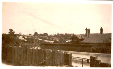
 Ringwood and District Historical Society
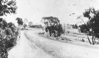
Photograph, Maroondah Highway Central, Ringwood. Main Street, c1909
... of dirt road looking west from Warrandyte Road with shops on right... of dirt road looking west from Warrandyte Road with shops on right ...Photograph (2 copies- 1 large black and white, 1 small sepia)Written on photograph: "Ringwood, Vic." Image shows view of dirt road looking west from Warrandyte Road with shops on right, and Station Masters house in background. Horse and dray in middle of road. -
 Port Melbourne Historical & Preservation Society
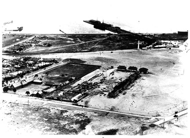
Photograph - Aerial view of first Bank Houses in Garden City, 1927
... Street and Williamstown Road, west wing of Station Pier... Road, west wing of Station Pier ("Rotomahana" at pier ...Photographic copies from black and white aerial photograph of the building of the first State Savings Bank Houses in Garden City 1927, showing also Graham Street State School, Princes Pier, Graham Street and Williamstown Road, west wing of Station Pier ("Rotomahana" at pier)built environment - domestic, fishermans bend, garden city, education - primary schools, melbourne harbor trust - port of melbourne authority, state savings bank of victoria, graham street state school, port melbourne primary school, bank houses -
 Whitehorse Historical Society Inc.
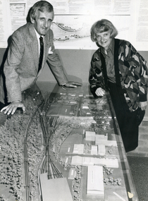
Photograph, Cr. Valda Arrowsmith & L. Fell, C.1987-88
... Government Proposal for West of Springvale Road, Nunawading...Whitehorse Historical Society Inc. 2-10 Deep Creek Road ...Black and white photo of Cr. Valda Arrowsmith, Mayor of City of Nunawading 1987-88, with Les Fell, C.E.O. of City of Nunawading with Model of Proposed Railway Development. State Government Proposal for West of Springvale Road, Nunawading. Defeated after Council & Community objections as unsuitable site.arrowsmith, valda, fell, les -
 Whitehorse Historical Society Inc.
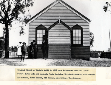
Photograph - Black & white photo, Church of Christ Blackburn
... in 1906, on South West cnr. Whitehorse Road and Albert Street... of Christ Built in 1906, on South West cnr. Whitehorse Road ...Used by donor in 'Blackburn - a picturesque history'Black & white photo of original Church of Christ Built in 1906, on South West cnr. Whitehorse Road and Albert Street. Later sold and removed..|Photo includes, Elizabeth Sanders, Miss Sanders, Alf Edwards, Edwin Schwab, Alf Schwab,Albert Hone and Theo Edwards.albert street blackburn, whitehorse road blackburn, sanders, elizabeth, miss, edwards, alf, schwab, edwin, hone, albert, theodore, blackburn church of christ -
Glenelg Shire Council Cultural Collection
Photograph - Photograph - oil tanks, n.d
... Black and white photograph showing shell oil tanks west... Cliff Street Portland great-ocean-road Port of Portland ...Port of Portland Authority Archivesport of portland archives, fishermans breakwater -
 Bendigo Historical Society Inc.
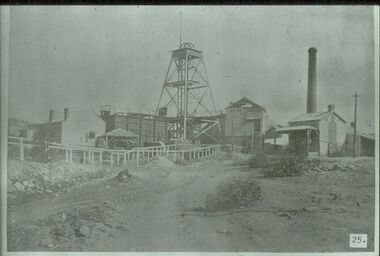
Slide - ALBERT RICHARDSON COLLECTION: NEW MOON GOLD MINE, EAGLEHAWK
... Slide. .New Moon Gold Mine, Eaglehawk. Mine situated west.... Mine situated west of Beebzlebub Road, Eaglehawk. Poppet head ...Slide. .New Moon Gold Mine, Eaglehawk. Mine situated west of Beebzlebub Road, Eaglehawk. Poppet head in centre of image, brick chimney and mine buildings on RH side, ore bins and mine sheds on LH side. Image sourced from 'Healthy, Golden Bendigo' book.No. 25 printed on bottom of slidemine, gold, new moon., bendigo mines-jack hattam collection -
 Bendigo Historical Society Inc.
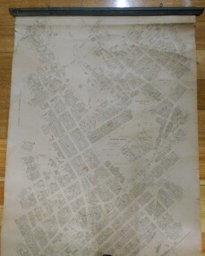
Map - MAP: BENDIGO SHEET 2, 1910, 1910
... owners. Bendigo from Olinda Street west to Prouses Road..., showing names of property owners. Bendigo from Olinda Street west ...Map. Map with timber ends, showing names of property owners. Bendigo from Olinda Street west to Prouses Road and Bennet / Wattle Street to Dooley Street in the north. Copy of map taken for research purposes. Map prepared by Department of Lands and Survey, Melbourne by T.F. McGauran 4.1.10 (1910)map, bendigo, residence areas, 1910 -
 Kew Historical Society Inc
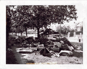
Photograph - Hard rubbish in the City of Kew
... Reverse: "17th Nov 1969 8.45am. / Parkhill Road West... Reverse: "17th Nov 1969 8.45am. / Parkhill Road West of Adeney ...One of eight photographs donated by the City Engineer of the former City of Kew, mostly of hard rubbish clearance during the period 1969-1985.One of a dated series of photographs of core local government services as practised by the City of Kew in the period 1969-1985. Original black and white photographic positive of unburnable hard waste awaiting collection in Parkhill Road in the City of Kew.Reverse: "17th Nov 1969 8.45am. / Parkhill Road West of Adeney Avenue" In envelope marked: "Kew City Council / 12 photos / 1969 1979 18980 1985 / Unburnable rubbish units 18/1/80"garbage, hard rubbish, garbage removal, city of kew, local government -- city of kew, household waste, hard waste -
 Kew Historical Society Inc
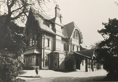
Photograph - 'Tara Hall', Studley Park Road, 1890-1900
... Ramsden, 49 Kamilaroy Road, West Pymble 2073 N.S.W. Dec.1979."... Ramsden, 49 Kamilaroy Road, West Pymble 2073 N.S.W. Dec.1979 ...During construction, commentators described the house as being in the ‘Elizabethan style’. The architectural style of the exterior, with its innovatory use of red brick and Italian tiles was more influenced by American models. Edward George Kilburn, of Ellerker & Kilburn, designed Byram for the industrialist George Ramsden in 1888.This is an original small photograph of this historic Kew mansion with provenance by descent from the first owners of the house.The main entrance to Tara Hall (previously named Byram, Goathland and Lowan). The entrance, through a porte-cochère, was located on the east side of the house. Inscription reverse: KH-323 Tara Hall once stood on Studley Pk Road on vast landscaped gardens. Donated by Mr Peter Ramsden, 49 Kamilaroy Road, West Pymble 2073 N.S.W. Dec.1979."byram, tara hall, lowan, goathland, edward g. kilburn (architect), george ramsden -
 Ballarat Tramway Museum
Slide - 27 mm sq slide/s - set of 5, Lilian Butler, Sturt St West, 1971
... - Sturt St West curve into Hamilton Ave, looking west, shows road... into Hamilton Ave, looking west, shows road signs and the state ...Yields information about Sturt St West track.Set of 5 AGFA slides - blue and white plastic mounts: .1 - Sturt St West curve into Hamilton Ave, looking west, shows road signs and the state of the road. .2 - Parker St, showing the west end of the loop and a Warning Oncoming Trams signs. .3 - West of Parker St, looking west. .4 - Curve at Pleasant St from Sturt St to Sturt St West. .5 - Curve into Hamilton Ave from Sturt St West. Photo from the collection of Lilian Butler. ballarat, tramways, trams, sturt st west, parker st loop, signs, pleasant st, hamilton ave -
 Phillip Island and District Historical Society Inc.
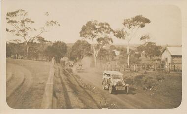
Photograph - Post Card, Cowes School Back to 1926 Chapel Street, March 1926
... , driving along Chapel Street going west on unmade road. Land... going west on unmade road. Land on left was owned by Methodist ...Donated by Stan McFee from the Keith McIlwraith CollectionSepia postcard of four cars , decorated with streamers, driving along Chapel Street going west on unmade road. Land on left was owned by Methodist Church, corner of Chapel and Bass Ave., where large tree denotes the boundary. Finley? Forrest's house on right. Coming to Back to Cowes School Celebration March 1926On back: "Back to Cowes March 1926"celebrations - back to cowes school phillip island, decorated cars, phillip island, stan mcfee, keith mcilwraith collection -
 Hume City Civic Collection
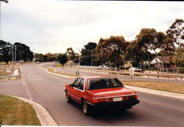
Photograph, Late 1990's
... A coloured photograph of Riddell Road looking west. A red... and is on the west side of the town centre. It is the main road to Riddells ...Riddell Road is the continuation of Macedon Street and is on the west side of the town centre. It is the main road to Riddells Creek, the Sunbury airstrip, Sunbury tip and water towers.A coloured photograph of Riddell Road looking west. A red car is in the foreground travelling north and is at the T intersection of Riddell Road and Ligar Street. There are houses along the north side of Riddell Road and the football ground is on the south side of the road.sunbury football club, riddell road, ligar street, george evans collection -
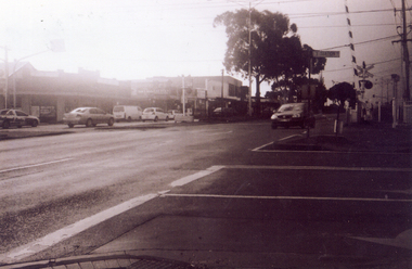
 Eltham District Historical Society Inc
Negative - Photograph, J.A. McDonald, Sherbourne Road, Montmorency, c. July 1962
... View looking west across Sherbourne Road to intersection... melbourne View looking west across Sherbourne Road to intersection ...View looking west across Sherbourne Road to intersection of Rattray Road from present-day forecourt entrance to 7-Eleven Eltham service station The BP Service Station is now an Ampol Service Station (2022) Google Street View Apr.. 2022 https://goo.gl/maps/LM4APKCwj1ohBDPv5Record of various Shire of Eltham infrastructure works undertaken during the period of 1952-1962 involving bridge and road reconstruction projects, sometimes with Eltham Shire Council Project Reference numbers quoted. It was during this period that a number of significant improvements were made to roads and new bridges constructed within the shire that remain in place as of present day (2022). In many situations, the photos provide a tangible visible record of infrastructure that existed throughout the early days of the Shire. The album was put together by or under the direction of the Shire Engineer, J.A. McDonald.1962-07, ampol service station, bp service station, montmorency, rattray road, service station, sherbourne road, graders, infrastructure, public telephone box (red), reconstruction works, road construction, shire of eltham -
 Eltham District Historical Society Inc
Negative - Photograph, J.A. McDonald, Sherbourne Road, Montmorency, c. July 1962
... View looking west across Sherbourne Road to intersection... melbourne View looking west across Sherbourne Road to intersection ...View looking west across Sherbourne Road to intersection of Rattray Road from present-day forecourt entrance to 7-Eleven Eltham service station The BP Service Station is now an Ampol Service Station (2022) Google Street View Apr.. 2022 https://goo.gl/maps/LM4APKCwj1ohBDPv5Record of various Shire of Eltham infrastructure works undertaken during the period of 1952-1962 involving bridge and road reconstruction projects, sometimes with Eltham Shire Council Project Reference numbers quoted. It was during this period that a number of significant improvements were made to roads and new bridges constructed within the shire that remain in place as of present day (2022). In many situations, the photos provide a tangible visible record of infrastructure that existed throughout the early days of the Shire. The album was put together by or under the direction of the Shire Engineer, J.A. McDonald.1962-07, ampol service station, bp service station, montmorency, rattray road, service station, sherbourne road, infrastructure, reconstruction works, road construction, shire of eltham -
Glenelg Shire Council Cultural Collection
Photograph - Photograph - Julia Street, Portland, 1930s
... . Portland, taken from middle of road, looking west, left hand side... from middle of road, looking west, left hand side, block ...Black and white photo, white border. View of Julia St. Portland, taken from middle of road, looking west, left hand side, block between Bentinck and Percy Streets. Four cars, 1 motorbike, road not sealed.'JULIA STREET, PORTLAND', black print, lower borderphotography, julia street, portland -
 Kew Historical Society Inc
Photograph - Corner of Normanby and Parkhill Roads, Kew, 1926
... and Parkhill Road West were both gazetted in 1865.... and Parkhill Road West were both gazetted in 1865. normanby road -- kew ...The section of Normanby Road, Kew from Cotham Road to Parkhill Road was officially gazetted in 1865. The part of Normanby Road between Parkhill Road and Harp Road was gazetted ten years later in 1875. Parkhill (sometimes Park Hill) Road East and Parkhill Road West were both gazetted in 1865.Original, black and white positive print of a photograph taken from a house in Normanby Road across the road to another house on the corner of Normanby and Parkhill Roads. The hills of Kew can be seen in the background. The main house in the photo is 57 Normanby Road.Inscribed verso: "Normanby Rds and Parkhill Rds corner " normanby road -- kew (vic.), parkhill road -- kew (vic.), 57 normanby road -- kew (vic.) -
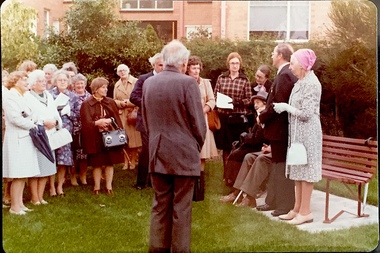 Kew Historical Society Inc
Photograph - Opening of the Dorothy Rogers Reserve, 1976
... Road just west of Kew Junction. ... Road just west of Kew Junction. Photograph Opening ...Dorothy Rogers wrote two major books on Kew's history: Lovely Old Homes of Kew (1961) and A History of Kew (1973). In addition to her published works, she was a regular contributor on issues of local history to suburban newspapers. Her archives are held in the collections of the State Library of Victoria and Kew Historical Society. Three years after her death in 1973, the Reserve was opened in her honour.Faded colour positive photograph of the opening of the Dorothy Rogers Reserve in 1976. The naming of the reserve honoured the contribution of the historian Dorothy Rogers, foundation member of the Society. The reserve is located on the north side of Studley Park Road just west of Kew Junction. Inscribed verso: "Members and relatives of the late Dorothy Rogers. Memorial reserve named and unveiled in her honour by (Cr Whiting Mayor) and City Manager Mr Fell 1978. In respect for her great research and service to the history of early Kew, and other places."dorothy rogers reserve, public parks -- kew (vic.) -
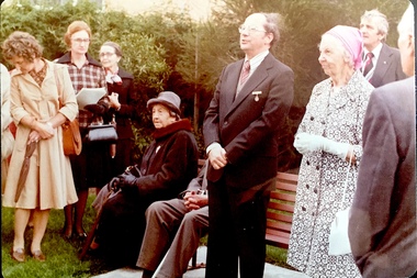 Kew Historical Society Inc
Photograph - Opening of the Dorothy Rogers Reserve, 1976
... Road just west of Kew Junction. ... Road just west of Kew Junction. Photograph Opening ...Dorothy Rogers wrote two major books on Kew's history: Lovely Old Homes of Kew (1961) and A History of Kew (1973). In addition to her published works, she was a regular contributor on issues of local history to suburban newspapers. Her archives are held in the collections of the State Library of Victoria and Kew Historical Society. Three years after her death in 1973, the Reserve was opened in her honour.Faded colour positive photograph of the opening of the Dorothy Rogers Reserve in 1976. The naming of the reserve honoured the contribution of the historian Dorothy Rogers, foundation member of the Society. The reserve is located on the north side of Studley Park Road just west of Kew Junction. Inscribed verso: "Left to right: Mrs Rogers Jnr, Joy Stewart, Miss Jenkins sitting / Mrs Richardson and Mr Richardson, Brother of D. Rogers), Mayor Cr Whiting, City Manager Mr Fell, Background / KHS President Miss Hall, Mr B O'Neill KHS member, / taken during the memorial unveiling of the Dorothy Rogers Reserve"dorothy rogers reserve, public parks -- kew (vic.) -
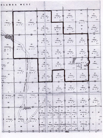 Tatura Irrigation & Wartime Camps Museum
Map, Part Murchison North Parish Plan
... Road west of the Tatura Murchison Road was unfenced in those... Road west of the Tatura Murchison Road was unfenced in those ...Ownership detail obtained from S.R. & W.S.C. rate book 1933. Part Murchison North Parish Plan with extent of "Kiota" property outlined, as in 1933, owned by Gerald N. Buckley, purchased in 1936 by Pargeter, and held until 1943. Note that Kiota Road west of the Tatura Murchison Road was unfenced in those years.kiota estate, pargester,buckley, dhurringile. -
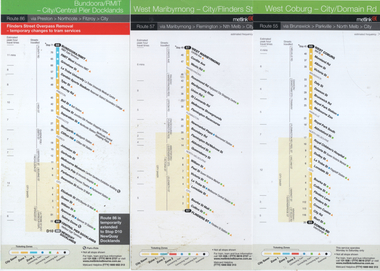 Melbourne Tram Museum
Ephemera - Tram Route Guide, Metlink, 2005
... Route guides for route 55 (West Coburg - Domain Road... Route guides for route 55 (West Coburg - Domain Road), route 47 ...Route guides for route 55 (West Coburg - Domain Road), route 47 (West Maribyrnong) and route 86 (Bundoora - Central Pier) which has a note about the Flinders St overpass removal in 2005. See item 1253 for details and associated route guides. Has the logos of Yarra Trams, Metlink and Metcard.Demonstrates Metlink / Yarra trams route guides.Set of 3 DL pamphlets - full colourtramways, timetables, maps, route 57, route 55, route 86 -
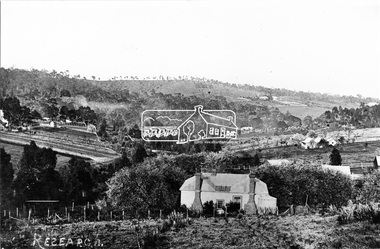 Eltham District Historical Society Inc
Photograph, Research, Vic
... as centre left Ref. 512. Looking about south-south west, down... as centre left Ref. 512. Looking about south-south west, down ...Research. House in centre foreground is same house as centre left Ref. 512. Looking about south-south west, down Research Gully Road. Source: Mrs. E.R. Reynolds, Thompson Crescent, ResearchThis photo forms part of a collection of photographs gathered by the Shire of Eltham for their centenary project book,"Pioneers and Painters: 100 years of the Shire of Eltham" by Alan Marshall (1971). The collection of over 500 images is held in partnership between Eltham District Historical Society and Yarra Plenty Regional Library (Eltham Library) and is now formally known as the 'The Shire of Eltham Pioneers Photograph Collection.' It is significant in being the first community sourced collection representing the places and people of the Shire's first one hundred years.Digital imagesepp, shire of eltham pioneers photograph collection, research (vic.) -
Tatura Irrigation & Wartime Camps Museum
Document, William McCartney's Houses & Stable
... at Byrneside on the north west corner of Brewer Road and the Tatura... selected at Byrneside on the north west corner of Brewer Road ...Material loaned for copying. Report prepared in 2001 on the remaining log house and stables on the property selected at Byrneside on the north west corner of Brewer Road and the Tatura Byrneside Road. Report contains copy of photographs and records. -
 Whitehorse Historical Society Inc.
Photograph, Service Station -Now Works Site Office, 1/06/2009
... . This photograph is former Service Station on west side of Springvale Road... Station on west side of Springvale Road. Now works site office ...One of a collection of photographs taken of the Nunawading Railway Station prior to the lowering of the railway line and building of the new railway station on the western side of Springvale Road so that the Springvale Road Rail Crossing can be eliminated.Black & white photograph of he precinct surrounding the Nunawading Station and the Springvale Road Railway crossing. This photograph is former Service Station on west side of Springvale Road. Now works site office. See NP 3545 to NP3567 for the complete set of photographsnunawading railway station, springvale road nunawading, redevelopment of railway line/springvale road. -
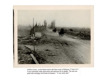 Lara RSL Sub Branch
Photograph of Hell-Fire Corner, Belgium 27/9/1917, Black and White photograph Hell-fire corner, Belgium 27/9/1917
... Belgium: Flanders, West-Vlaanderen, Ypres, Menin Road... the scene. Belgium: Flanders, West-Vlaanderen, Ypres, Menin Road ...Photographic details of Ypes sector, Belgium 27/9/1917. Hellfire corner.Photographic details of Ypes sector, Belgium 27/9/1917 Area known as Hellfire Corner.Belgium: Flanders, West-Vlaanderen, Ypres, Menin Road, Hellfire Corner, on the Menin Road in the Ypres sector of Belgium 27/9/1917. It was continually under observation and notorious for its danger The area was piled with wreckage of all kinds of transport. "A very sticky spot."An A4 sheet of paper with a black and white photograph of Hellfire Corner attached in the center. and a small note describing the scene.belgium, ypres sector, 1917, hellfire corner -
Glen Eira Historical Society
Document - Grange Road, 77, Glen Huntly
... Road, south west corner with Neerim Road, then in the suburb...Grange Road, south west corner of Neerim Road, Glen Huntly... Road, south west corner with Neerim Road, then in the suburb ...This file contains one item about the sale and history of the then unnumbered property and the first owners of the home at 77 Grange Road, south west corner with Neerim Road, then in the suburb of Carnegie: 1/ A typed sheet with the details and documents that were given to the society in 1987. These are biographical details provided by the son of Hulbert Gorrie, a Chemist who worked at Rankin and Eyval Chemists shop at 165 Glenhuntly Road (from around 1920 to 1957). Hulbert and his wife Gertrude Gorrie purchased the vacant block and built the first house at the address in 1936. The photo mentioned of Hulbert at the shop is held in our file 1080A Glenhuntly Road Elsternwick. gorrie gertrude, gorrie hulbert hopetoun, barnard ernest franklin, hobart john bertram, grange road, neerim road, elsternwick, contract of sale of land, dwelling, land, e.j & h amos, hintons nursery, real estate agents, builder, glen huntly, coorigil road, murrumbeena, emma st, caulfield, parish of prahran, caulfield county of bourke, legal document, chemist, rankin and eyval shop, glenhuntly road, carnegie, glen huntly road -
Mission to Seafarers Victoria
Letter - Correspondence, 1948
... Brunswick Road, West Brunswick, Victoria. Post-marked New York, NY... Brunswick Road, West Brunswick, Victoria. Post-marked New York, NY ...Quinn CollectionBlue, self-folding letter (0376), dated 22/06/48 and written on S.S.Lali, whilst in New YorkLetter is addressed to Mrs S Quinn, C/- Mrs Blackmore, 140 Brunswick Road, West Brunswick, Victoria. Post-marked New York, NY. Return address is S.S. Lali, C/- Thar Ekert & Co. 19 Rector Street, New York Cletters-from-abroad, quinn, 1948, new york, s.s.lali -
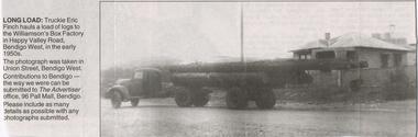 Bendigo Historical Society Inc.
Newspaper - JENNY FOLEY COLLECTION: LONG LOAD
... to the Williamson's Box factory in Happy Valley Road, Bendigo West... in Happy Valley Road, Bendigo West, in the early 1950s ...Bendigo Advertiser "The way we were" from Monday, February 7, 2005. Long load: truckie Eric Finch hauls a load of logs to the Williamson's Box factory in Happy Valley Road, Bendigo West, in the early 1950s. This photograph was taken in Union Street, Bendigo West.newspaper, bendigo advertiser, the way we were -
 Whitehorse Historical Society Inc.
Photograph, Railway Station from Car Park, 1/06/2009
... the Nunawading Station and the Springvale Road Railway crossing...Whitehorse Historical Society Inc. 2-10 Deep Creek Road ...One of a collection of photographs taken of the Nunawading Railway Station prior to the lowering of the railway line and building of the new railway station on the western side of Springvale Road so that the Springvale Road Rail Crossing can be eliminated.Black & white photograph of the precinct surrounding the Nunawading Station and the Springvale Road Railway crossing. This photograph is of the station taken from the car park on west side of Springvale Road, north of railway line behind Recreation Centre. See NP 3545 to NP3567 for the complete set of photographsnunawading railway station, springvale road nunawading, redevelopment of railway line/springvale road, nunawading recreation centre