Showing 1550 items matching " aerial photographs"
-
 Port Melbourne Historical & Preservation Society
Photograph - Aerial view of the mouth of the Yarra from Williamstown, 2006
... and the city upper right. Photograph Aerial view of the mouth ...B&W aerial photographic view of the mouth of the Yarra River, taken from above Williamstown and looking east. Greenwich Bay and the cooling water outlet for Newport Power Station in the foreground, the entrance and Webb Dock in the centre, Sandridge Beach and the city upper right.piers and wharves - webb dock, yarra river, garden city, fishermans bend, newport power station -
Port Melbourne Historical & Preservation Society
Photograph - Aerial view of HMS Hood, Port Phillip Bay, Royal Australian Air Force (RAAF), 1924
... Hood coming up the bay Photograph Aerial view of HMS Hood, Port ...Air Force aerial photos of the visit of HMS Hood and HMS Repulse 1924 01 - HMS Hood coming up the baypiers and wharves - princes pier, transport - shipping, armed services - navy, hms hood, hms repulse, ss james patterson -
Port Melbourne Historical & Preservation Society
Photograph - Aerial view of HMS Repulse with tug James Patterson passing Williamstown, Royal Australian Air Force (RAAF), 1924
... Photograph Aerial view of HMS Repulse with tug James Patterson ...Air Force aerial photos of the visit of HMS Hood and HMS Repulse 1924 02 - HMS Repulse passing Williamstown with the tug James Pattersonpiers and wharves - princes pier, transport - shipping, armed services - navy, hms hood, hms repulse, ss james patterson -
Port Melbourne Historical & Preservation Society
Photograph - Air Force Band and personnel, Princes Pier, Port Melbourne, Royal Australian Air Force (RAAF), 1924
Air Force aerial photos of the visit of HMS Hood and HMS Repulse 1924 03 - Air Force band and personnel on Princes Pierpiers and wharves - princes pier, transport - shipping, armed services - navy, hms hood, hms repulse, ss james patterson -
Port Melbourne Historical & Preservation Society
Photograph - Aerial view of HMS Repulse being berthed at outer west Princes Pier by tug James Patterson, Port Melbourne, Royal Australian Air Force (RAAF), 1924
... Patterson. New beacons are visible Photograph Aerial view of HMS ...Air Force aerial photos of the visit of HMS Hood and HMS Repulse 1924 04 - HMS Repulse being berthed at Outer West Princes Pier by tug James Patterson. New beacons are visiblepiers and wharves - princes pier, transport - shipping, armed services - navy, hms hood, hms repulse, ss james patterson -
Port Melbourne Historical & Preservation Society
Photograph - Aerial view of J Kitchen & Sons site, Port Melbourne, C D Pratt Airview, 21 Mar 1939
... and white photograph of J Kitchen & Sons Pty Ltd. On back "Aerial ...COPYRIGHT C D PRATT Black and white photograph of J Kitchen & Sons Pty Ltd. On back "Aerial view looking North East, 21st March 1939". Signs on three middle buildings 'J Kitchen & Sons Pty Ltd'; 'Pure Velvet Soap'; 'Electrine Candles'. Sign 'Australian Box Mills' on building to left "E L Pinkus' on building to Nort east and behind it 'Petersen & La...'"This photo is copyright" and information on owner - C D Pratt 86 McCracken St, Essendonindustry - manufacturing, j kitchen & sons pty ltd, australian box mills, e l pinkus, petersen -
Port Melbourne Historical & Preservation Society
Photograph - Aerial view showing route of Lower Yarra Crossing Project (West Gate Bridge), Apr 1966
... Photograph Aerial view showing route of Lower Yarra Crossing Project ...Black and white aerial photomap showing the proposed route of the Lower Yarra Crossing Project, later to become the West Gate Bridge and Freeway. April 1966'Lower Yarra Crossing Project' '296769'west gate bridge, transport - roads, engineering - bridges -
Port Melbourne Historical & Preservation Society
Photograph - Aerial view of (finally) in-filled Lagoon, Port Melbourne, 1931
... Street Photograph Aerial view of (finally) in-filled Lagoon, Port ...Image seems to be one of several aerial shots around 1931, possibly all shot from one flight. Aerial photo of Port Melbourne c1931 showing clearly the finally filled Lagoon, and central area from Gasworks to past Bay Street, from Town Hall to Town Pier. Cable tram cars can be seen on Bay Streetsandridge lagoon, built environment -
Port Melbourne Historical & Preservation Society
Photograph - Aerial view of Port Melbourne, circa 1928
... Joshua Brothers Distillery Harpers Starch Factory Aerial photo ...Aerial photo of Port Melbourne c1928 focusing on the Gas Works area spanning Port Melbourne and Albert Park. Shows the finally filled Lagoon, and area from the Harpers Starch factory to Foote St, Albert Park and from the bay to just over Richardson/Liardet Stssandridge lagoon, built environment - industrial, industry, gasworks, joshua brothers distillery, harpers starch factory -
Port Melbourne Historical & Preservation Society
Photograph - Aerial view of land reclamation at Webb Dock, Port Melbourne, 1997
... , 1997 Photograph Aerial view of land reclamation at Webb Dock ...Colour aerial photo showing land reclamatioon at Webb Dock, 1997piers and wharves - webb dock, melbourne harbor trust - port of melbourne authority -
Port Melbourne Historical & Preservation Society
Document - Report, Plan of General Development, Mr J Green (Government Printer), Plan of General Development, 1929
Plan of General Development. Melbourne Report of Metropolitan Town Planning Commission, 1929. Was passed on by local history librarian as it was no longer required. On p63 shows view up Swallow Street and contrasts it with approach of St Kilda. P42 aerial view of Port Melbourne piers. Also includes maps and photographs.town planning, piers and wharves, swallow street -
 Port Melbourne Historical & Preservation Society
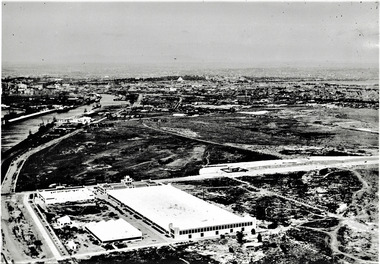
Photograph - Aerial view of Fisherman's Bend circa 1940, circa1940
... & South Wharves. Photograph Aerial view of Fisherman's Bend circa ...From the collection of Terry KEENAN. The 9 hole golf course known as the Sandridge Golf Club was part of Victorian Golf Clubs until it moved to Cheltenham in 1927. Trotting 'Speedway' located at top right of photograph.Black and white photograph of Fishermans Bend, Port Melbourne, c. 1940 showing General Motors Holden in the foreground. The original home of the Victoria Golf Club is shown on the left beside the Yarra River winding towards the city & North & South Wharves. built environment, fishermans bend, built environment - industrial, general motors-holden, victoria golf club, sport - golf, sport - horse racing -
Port Melbourne Historical & Preservation Society
Photograph - Digital images of aerial views over Station and Princes Piers, GMH and Fishermans Bend and images of Guard of Honour in March 1924, 18 Mar 1924
... FIELD Royal Navy Two digital images of aerial views over GMH ...Guard of Honour at Princes Pier for Vice Admiral Sir Frederick FIELD, Royal Navy. Donor's father, Eric DOUGLAS is on left in front row.Two digital images of aerial views over GMH, two digital images of aerial views over Fishermans Bend, one digital image of Princes and Station Piers and two digital images of Guard of Honour in March 1924.piers and wharves - princes pier, eric douglas, sir frederick field, royal navy -
Port Melbourne Historical & Preservation Society
Photograph - Aerial view of Port Melbourne, c. 1990
... (recollections only). Photograph Aerial view of Port Melbourne ...Notations made as a result of conversations Anne had in the early 1990's with an elderly male resident of Port Melbourne.Map and aerial photo of Port Melbourne with handwritten annotations detailing the location of various buildings, trotting tracks, etc which previously existed in Port Melbourne (recollections only).fishermans bend -
Port Melbourne Historical & Preservation Society
Photograph - Aerial view of Port Melbourne, c. 1972
... Melbourne c1972 Photograph Aerial view of Port Melbourne ...Aerial photographic view of Port Melbourne c1972local government - city of port melbourne -
Port Melbourne Historical & Preservation Society
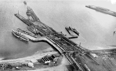
Photograph - Aerial view of Williamstown piers and Alfred Graving Dock, Port of Melbourne Authority, c. 1925
... with chequered computer border Photograph Aerial view of Williamstown ...Black and white aerial photo of Williamstown Piers and Alfred Graving Dock, with caption, both pasted onto paper with chequered computer bordertransport - shipping, piers and wharves, williamstown, alfred graving dock -
Port Melbourne Historical & Preservation Society
Photograph - Aerial view of the commencement of Appleton Dock, Aug 1925
... with chequered computer border Photograph Aerial view of the commencement ...Black and white aerial photo of Commencement of Appleton Dock and construction of new river berths, with caption, both pasted onto paper with chequered computer bordertransport - shipping, piers and wharves, yarra river, appleton dock -
Port Melbourne Historical & Preservation Society
Photograph - Aerial view of American destroyers at Victoria Dock, 6 Aug 1925
... with chequered computer border Photograph Aerial view of American ...Copy of aerial photo of Victoria Dock 1925 with destroyers from visiting American fleet, with caption, both pasted onto paper with chequered computer bordertransport - shipping, piers and wharves - miscellaneous, victoria dock -
 Port Melbourne Historical & Preservation Society
Photograph - Aerial view during construction of Station Pier, Port Melbourne, c. 1925
... and Wharves - Railway Pier PS Weeroona PS Hygeia Aerial photo showing ...Aerial photo showing the double-headed pier created by partially dismantled Railway Pier and partially built Station Pier, late 1920s. Also the new wing piers with paddlesteamers Hygeia, Weeroona and Ozone (latter being broken up), foreshore and railyards, and end of Princes Pier. Pasted on A4 paper printed with computer generated chequered border.transport - shipping, piers and wharves - station pier, piers and wharves - railway pier, ps weeroona, ps hygeia -
Port Melbourne Historical & Preservation Society
Photograph - Aerial view of River Yarra and Victoria Dock, 1920s
... border Photograph Aerial view of River Yarra and Victoria Dock ...Copy of aerial photo of River Yarra and Victoria Dock, 1920s; pasted onto A4 sheet with computer graphics bordertransport - shipping -
 Port Melbourne Historical & Preservation Society
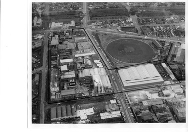
Photograph - Aerial view of J Kitchen & Sons site, Port Melbourne
... industrial to the North. Photograph Aerial view of J Kitchen & Sons ...The source of the images is unknown. The date has been estimated in reference to catalogue items 2989 (approx 1945) and 2990 (approx 1970) - both aerial photos of the area.Two black and white aerial photos of J Kitchen & Sons factory prrecinct, approximately 1960s. .01- Looking towards the East with Ingles St in the centre and Port Melbourne cricket/football ground on the right. Rail line is at the top. The Kitchen property is outlined. .02 - Looking towards the North with Port Melbourne cricket/football ground at the bottom, Kitchens (outlined) in the centre and other industrial to the North.built environment - industrial, industry - manufacturing, sport - australian rules football, business and traders - soaps/candles, j kitchen & sons pty ltd, port melbourne football and cricket ground, north port oval -
 Port Melbourne Historical & Preservation Society
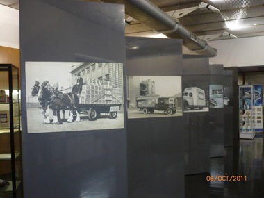
Photograph - Pental/Symex Museum, Woodruff Street, Port Melbourne, Oct 2011
The pictures were taken in October 2011 by PMHPS members and in February 2013 the contents of the museum were given to PMHPS for safekeeping prior to the closure of the site.Pictures taken inside the Pental/Symex museum in Woodruff St building. Displaying historical items and photos of interest in relation to the activities of J Kitchen & Sons on this site. (.01) some of the display boards within the museum (.02) a framed aerial photographic view of the site (.03) Ledgers, photographs, trophies (.04) bench with books, photos, candlesticks (.05) framed aerial view of the site plus other photos and ledgers (.06) full wall and bench of display (.07) Horse drwan cart of Velvet soap - one of the display boards mentioned in .01 (.08) Open truck loaded with Velvet soap - one of the display boards mentioned in .01 (.09) Framed photo of Candle Room - one of the display boards mentioned in .01 (.10) Velvet Soap truck, enclsed van - one of the display boards mentioned in .01built environment - industrial, business and traders - soaps/candles, j kitchen & sons pty ltd, pental products pty ltd, symex holdings ltd -
 Monbulk RSL Sub Branch
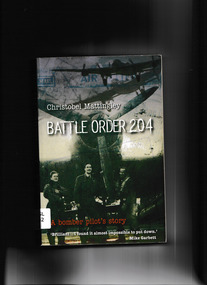
Book, Allen and Unwin, Battle Order 204 : A Bomber Pilot's Story, 2007
The riveting true story account of a young WW2 pilot's heroic journey, illustrated throughout with fascinating photographs, maps and excerpts from his log books.Bibliography, ill, map, p.305.non-fictionThe riveting true story account of a young WW2 pilot's heroic journey, illustrated throughout with fascinating photographs, maps and excerpts from his log books.world war 1939 – 1945 – aerial operations - britain, world war 1939 – 1945 – personal narratives – australia -
 Bendigo Historical Society Inc.
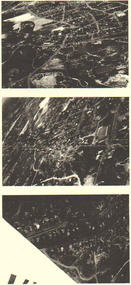
Photograph - LONG GULLY HISTORY GROUP COLLECTION: AERIAL PHOTOS
Copies of three dark aerial photos of suburban areas, possibly Long Gully. Photos show streets and buildings.bendigo, history, long gully history group, the long gully history group - aerial photos -
 Bendigo Historical Society Inc.
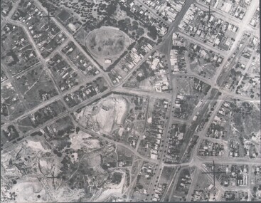
Photograph - HARRY BIGGS COLLECTION: AERIAL PHOTO OF EAGLEHAWK
... Collection Aerial photo of Eaglehawk Photograph. Harry Biggs ...Photograph. Harry Biggs Collection. A black & white overhead photo of Eaglehawk. It clearly shows the football ground, Canterbury Park, Town Hall precinct.place, streetscape, aerial view of eaglehawk, harry biggs collection, aerial photo of eaglehawk -
 Bendigo Historical Society Inc.
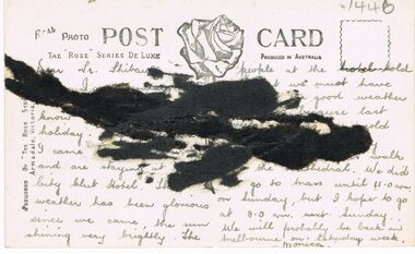
Photograph - BENDIGO - PANORAMA FROM FIRE TOWER
Photograph - sepia. Photograph panorama from Fire Tower, Bendigo.. In the distance shops that I can read 'Mobiloils', 'Cockings', 'Cocks Motor Garage', back view of the Conservatory building and gardens. The Rose Series P.3231. It is written on back but unable to read much, its from Monica. Trees etc along the bottom front are part the rosalind park.Rose Seriesplace, aerial view of bendigo, fire tower., bendigo. panorama from fire tower. -
 Victorian Interpretive Projects Inc.
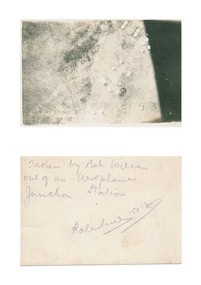
Photograph - digital, Bah Wilson, Aerial photograph of Palestine taken during World War One, 1918, 1918
... Aerial photograph of Palestine taken during World War One...aerial photograph..., 3350 goldfields palestine aerial photograph aeroplane world war ...verso: Taken by Bah Wilson out of an aeroplane. Junction Station. Palestine 1918palestine, aerial photograph, aeroplane, world war, world war one, junction station, mmm -
 Victorian Interpretive Projects Inc.
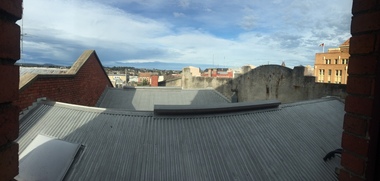
Photograph - Colour, Clare Gervasoni, Ballarat towards Sturt Street from the Ballarat Trades Hall, 2015, 30/07/2015
Rooflines and buildings from the top of the Ballarat Trades Hall in Camp Street Ballarat.ballarat trades hall, camp street, sturt street, ballarat, aerial -
 National Vietnam Veterans Museum (NVVM)
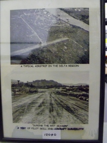
Photograph, A Typical Airstrip In The Delta Region
Two black and white photograph in a frame - Top photo is an aerial photo of an unknown airstrip in the Delta Region. Bottom photo depicts tyre tracks on the muddy airstrip during the wet seasonTop photo - 'A Typical Airstrip In The Delta Region' Bottom photo - 'During the wet season a test of pilot skill and aircraft durabilityairstrip, wet season, photograph -
 National Vietnam Veterans Museum (NVVM)
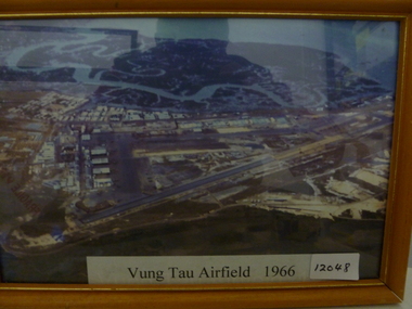
Photograph, Vung Tau Airfield 1966
Framed coloured aerial photo of Vung Tau airfield depicting runway infrastructure and surrounding buildings.Vung Tau Airfield -1966vung tau airfield, photograph