Showing 12222 items matching " reserves"
-
 Greensborough Historical Society
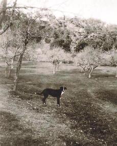
Photograph - Digital image, Old orchard at Partington Flat, 1930c
Remnants of the Partington orchard at Greensborough on land that is now the Partingtons Flat reserve in Greensborough. Charles Partington and family came to Melbourne in the 1840s and moved to Greensborough where they farmed along the Plenty River. This dog belonged to Jessie Partington.Digital copy of black and white photograph.partingtons flat, partington family -
 Sunbury Family History and Heritage Society Inc.
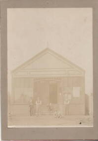
Photograph, Sunbury News Office, c1892
The building is the first Sunbury News Office that was owned by Arthur Boardman. In 1892 he began publishing the' Sunbury News' in this printing office which was on railway reserve near the station, which today is the bus terminal at Sunbury Station. The 'Sunbury News' was distributed throughout the Shire of Bulla and surrounding areas for almost 7 decades.A faded sepia non-digital photograph backed onto fawn coloured cardboard of a shop building with five people standing outside. sunbury news, arthur boardman -
 Greensborough Historical Society
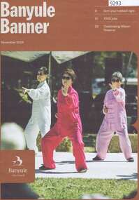
Magazine, Banyule City Council, Banyule Banner November 2024, 2024_11
The Banyule Banner is published by Banyule Council to advertise upcoming events in the City of Banyule and to report on past events. This edition contains reports on Council's major projects for the coming year, job creation in Banyule and the Wilson Reserve in Ivanhoe.A record of events within the City of Banyule.24 pages, colour illustrations. banyule banner, banyule council -
 Ringwood and District Historical Society
Photograph, Ringwood Reserve, East Corner, Looking south to the "Mail" office, mid 1960's
4 copies of same photograph with various inscriptionsTyped below one photograph, "Ringwood Reserve, 1963. Looking south Rusty Roof is "Ringwood Mail". 1966. Another has "Ringwood Oval Looking South. Rusty Roof is "Mail"Office in Adelaide St. Area No Eastland. 1965 on reverse. Another two have dates of 1962. -
 Kew Historical Society Inc
Photograph - Civic event in Stradbroke Park, 1976
Stradbroke Park. Extent: Kilby Road to Harp Road at Burke Road. Historical Documentation: 1851 - Portion 91 purchased by Edward Glynn; 1888 - The Harp of Erin Estate (which included Section 91) offered for sale; 1896 - The area now known as Stradbroke Park was bisected by a creek that flowed from the Yarra via Hay's Paddock (q.v.) and extended through to Burke Road; 1943 - W.D. Birrell, Town Clerk of Kew, proposed that the creek be filled and a reserve created; 1954 - Entire area designated as 'open space' and named 'Stradbroke Park'. The line of the creek that ran through the Park created a further reserve on the north side of High Street, now known as 'Harrison Reserve'. Existing Condition: The park is largely of mown grass that has mature trees set into it It is possible that a number of these are remnant of the original vegetation, while there are also a number of exotic trees introduced, particularly at the northern end of the park. The southern end is dominated by playing fields. (Source: Sanderson, P 1988. Kew Conservation Study)Colour photographic positive (with colour degradation) of sporting teams at a civic event in Stradbroke Park in Kew East in May 1976. The event was officiated by the Mayor of Kew, Cr Alan Hutchinson. Sporting teams in uniform included: footballers, athletes, cricketers, hockey players. Stradbroke Park is situated on the western boundary of Kew at Burke and Harp Roads.stradbroke park, cr alan hutchinson, team sports -- kew (vic.) -
 Kew Historical Society Inc
Photograph - Civic event in Stradbroke Park, 1976
Stradbroke Park. Extent: Kilby Road to Harp Road at Burke Road. Historical Documentation: 1851 - Portion 91 purchased by Edward Glynn; 1888 - The Harp of Erin Estate (which included Section 91) offered for sale; 1896 - The area now known as Stradbroke Park was bisected by a creek that flowed from the Yarra via Hay's Paddock (q.v.) and extended through to Burke Road; 1943 - W.D. Birrell, Town Clerk of Kew, proposed that the creek be filled and a reserve created; 1954 - Entire area designated as 'open space' and named 'Stradbroke Park'. The line of the creek that ran through the Park created a further reserve on the north side of High Street, now known as 'Harrison Reserve'. Existing Condition: The park is largely of mown grass that has mature trees set into it It is possible that a number of these are remnant of the original vegetation, while there are also a number of exotic trees introduced, particularly at the northern end of the park. The southern end is dominated by playing fields. (Source: Sanderson, P 1988. Kew Conservation Study)Colour photographic positive (with colour degradation) of sporting teams at a civic event in Stradbroke Park in Kew East in May 1976. The event was officiated by the Mayor of Kew, Cr Alan Hutchinson. Stradbroke Park is situated on the western boundary of Kew and bordered by Burke and Harp Roads.stradbroke park, cr alan hutchinson, team sports -- kew (vic.) -
 Federation University Historical Collection
Photograph - Photograph - Black and White, N.L. Harvey & Sons Photographers, Ballarat School of Mines Aerial View
The Ballarat School of Mines Campus is a campus of Federation University Australia.Aerial view of the Ballarat School of Mines campus from the Grant Stret/Eyre Street corner. The photograph was taken after the demolition of the gaol and before the E.J. Tippett Library and Hillman Recreation Reserve were built. The Ballarat Girls' Technical School is present in Grant Street, and in sthe Ballarat SChool of Mines Mining Laboratory in Albert Street. The Ballarat Brewery (then Carton and United Breweries) is present in Lydiard Street South.aerial, ballarat school of mines, ballarat gaol, ballarat school of mines tennis court, grant street, ballarat girls' junior technical school -
 Bendigo Historical Society Inc.
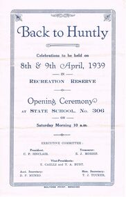
Document - LYDIA CHANCELLOR COLLECTION; BACK TO HUNTLY PROGRAMME
A yellow programme with blue print. On the front cover are the words ' Back to Huntly celebrations to be held on the 8th & 9th April, 1939 in Recreation Reserve. Opening Ceremony at State School No. 306 on Saturday Morning 10 a.m. Executive Committee: President C.F. Sinclair. Treasurer: E.J. Morris. Vice-Presidents: T. Caelli and T. A. Burt. Asst. D.P. Munro Hon. Secretary T.L. Tucker. Boltons Print, Bendigo.school, history, huntly primary school, lydia chancellor, collection, school -
Bendigo Historical Society Inc.
Document - TICKET - BENDIGO JOCKEY CLUB 1874-5 MEMBERS TICKET
White Members Ticket for the Bendigo Jockey Club 1874 - 5 in the name of John McIntyre Esq. W. P. Neal, Hon. Sec. Ticket has eyelet, on the left with a flat blue cord threaded through it. On rear 'The production of this Ticket entitles you, with two Ladies, to Free Admission to the Grand Stand at tbhe Club races, whith the priviledge of entrance foxr your carriage and horses to the Course and Carriage Reserve.bendigo, sporting clubs, bendigo jockey club, ticket, bedigo jockey club 1874-5 members ticket, john mcintyre esq., w p neal -
 Bendigo Historical Society Inc.
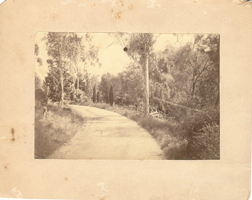
Photograph - BOTANICAL GARDENS
sepia photograph on cream board. Driveway/pathway, gravelled, eucalypt and conifer trees, uncut grass, wire fence middle distance. Pathway curving to left from front of photo. Written in blue pen on rear of photo : Botanical Gardens or early path in Fortuna. English trees planted, e.g. cypress. Holdsworth Road, adj. White Hills Cemetery Reserve. Crowned road grade. Heavy intermediate fence posts.unknownplace, land, botanical gardens, fortuna ? -
 Bendigo Historical Society Inc.
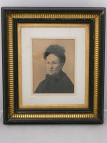
Photograph - MRS PIEPER, 1880
Black and white photo of Mrs Pieper. She is wearing a high neck dress and a small ostrich feather hair decoration. On back.. Dorothy Pieper of Piepers Hill. Atho? Pieper. Gilt frame. D1 533. Bartlett Bros. Sandhurst. From W.H.Brown. Practical Picture Frame Maker. Carver and gilder. Plush worker wtc. View street. Bendigo. Opposite Sports Ground. Upper reserve. Tram pass the door.Bartlett Bros, Sandhurstperson, individual, portrait female, pieper, pieper's hill, woman, hat -
 Bendigo Historical Society Inc.
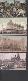
Postcard - BENDIGO POSTCARDS
Eleven postcard featuring 1907-9 views of Bendigo. 1. Returned Soldiers Monument. 2. Gold Jubilee Statue, 3. Lake & Picnic Pavilion, 4. State School Eaglehawk, 5. School of Mines 6. Entrance to Eaglehawk Gardens, 7. View Point & Fountain, 8. The Shamrock Hotel, 9. Mitchell St View, 10. Easter Fair Procession. 11. Lake Scene Upper Reserve.bendigo, parks and gardens -
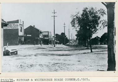 Whitehorse Historical Society Inc.
Photograph, Whitehorse Road, Mitcham, C1925
Black and white photo of Whitehorse Road, Mitcham looking west -1925. Note the Mitcham Hardware Store (Ironmongery), the Post Office and Drake & Co. Section shown is further west than actual corner. Monty Gray's ironmongery was approximately half way down the block between Mitcham Road and Station Street. Horse trough later moved to front of Reserve Hotel. Drake and Co. shown on one of their several locations.whitehorse road, mitcham, mitcham post office, drake & co, mitcham hardware store, ironmongery -
 Bendigo Historical Society Inc.
Document - NEW CHUM & VICTORIA LINES OF REEF - NOTES ON VICTORIA HILL FOR TOURIST ATTRACTION
Handwritten notes outlining a plan for Victoria Hill, Central Nell Gwynne and New Chum Hill to be the focal position for a tourist attraction. Outlines steps to be taken to do the work and a mining museum at the Central Nell Gwynne. On the back of the page is a sketch of Victoria & New Chum Hills. On the plan is the Battery, Rae, Rae's House, Rae's Open Cut, Wittscheibe, Midway, Victoria Quartz, Lansell's 180 Shaft and the Recreation Reserve.document, gold, new chum & victoria lines of reef, central nell gwynne, new chum hill, bendigo and district tourist development association, victoria hill, lansell's big 180, victoria quartz, rae's open cut -
Bendigo Historical Society Inc.
Document - Hustler Mine Sites
One page photocopy: section of a mining map, showing contour lines and mine locations of the following mines: Hustlers Royal Reserve 1775 ft Park Shaft Royal Hustlers Shaft 1150 ft Imperial Hustlers Shaft Hustlers Extended Hustler Trib Shaft 1970 ft. Great Extended Hustlers Great Extended Streets on the map: Barkly Street, Drought Street, Rosalind Street and Hope Street. -
 Bendigo Historical Society Inc.
Map - HUSTLER'S ROYAL RESERVE NO 2 MINE - PLAN OF THE HUSTLER'S ROYAL RESERVE NO 2 MINE
Plan of the Hustler's Royal Reserve No 2 Mine on the Hustler's Line of Reefs Bulletin No 33, Plate No VI. Boundary of Leases No 8898 and 8897 shown. Various levels shown and some geographical features. Geological Survey of Victoria emblem. H . Harman, Director, W. Dickson, Secretary for Mines and The Hon. J. Drysdale Brown, Minister of Mines and signed by H Whitdon, Underground Survey Office, Bendigo, September 1913. mining, parish map, hustler's royal reserve no 2 mine, hustler's line of reefs, geological survey of victoria, h herman, w dickson, the hon j drysdale brown mlc -
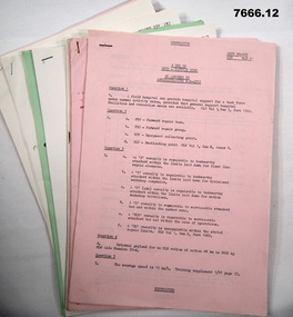 Bendigo Military Museum
Document - TRAINING NOTES - ARMY, 3rd Training Group
Notes relate to courses run by 3rd Training Group - Reserve Command and Staff college between May 1981 and May 1988. Part of the "Kevin John Herdman" No 397661 collection. See catalogue No. 5942P for his service details.1. - 12. A4 sized multi page documents, each stapled on top LHC. Text on each page in black type. Printing on one side of each page. Pages vary in colour - pink, cream, blue and green.Handwritten markings on various pages in red and black ink.training notes, army, 3rd training group, kevin john herdman -
 Greensborough Historical Society
Map, Melbourne and Metropolitan Board of Works. Survey Division, MMBW, Yarra 2500 / 12.23. Janefield and Kangaroo Point, 1977_10
Melbourne and Metropolitan Board of Works. Yarra 2500 [base map] 12-23, Municipalities of Whittlesea 239 and Diamond Valley 257. No streets marked on this map. Includes Plenty River, Kangaroo Point, Janefield Colony and Janefield Reserve.MMBW Map in 1:2500 [scale] series. Cream parchment with green tape reinforcing on edges and punched holes on left edge.mmbw, melbourne and metropolitan board of works, shire of diamond valley, plenty - maps -
Glen Eira Historical Society
Postcard - GLEN HUNTLY
This file contains 1 item about Glen Huntly: 1/1 colour postcard (150mm x 96mm) attributed to Margie McKenzie Photography, undated. It depicts Garden Avenue Reserve, Glen Huntly (Mel Ref 68F6)parks and reserves, glen huntly, garden avenue, garden avenue park, gardens -
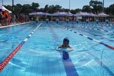 Galen Catholic College
Galen Catholic College Swimming Carnival, 2022
Galen Catholic College has a swimming carnival every year. This series of photographs captures the unbridled enthusiasm of the competitors and supporters alike. This swimming carnival was one of the first held at the new outside Olympic pool at the Barr Reserve in Wangaratta. galen catholic college, galen college, swimming, swimming carnival, 2022 -
Tatura Irrigation & Wartime Camps Museum
Photograph - original, N. R. McGeehan photographer, Cross Silver Wedding 1933, 1933 original
Original photograph of group of people celebrating the Cross silver wedding. 5 August 1933. Jack Welpdale (bottom right hand corner), Bertha (wife) next in coat with fur on collar and cuffs. Former residents of "Reserve" Tatura.Black and white photograph of the Cross silver wedding 1933.on back: Jack and Bertha Whelpdale, identified. -
Canterbury History Group
Letter - Vaughan Avenue and Flinders Street Reserve, Canterbury, Bennet, Mavis and Potts, Annette, 1/05/1989 12:00:00 AM
Copy of correspondence to John Niemann Manager, Urban Design, City of Camberwell requesting the creek at the end of Vaughan Avenue and Flinders Street Canterbury be named Shrublands Creek Reserve, and the letter in reply from the City of Camberwell agreeing to the request.A 4 3 pagescanterbury, vaughan avenue, flinders street, city of camberwell, shrublands creek reserve, creeks, potts> annette, bennett> mavis -
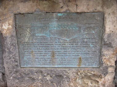 Greensborough Historical Society
Photograph - Digital image, Dennis Ward, Bridge Plaque - Pioneer Park Greensborough, 27/03/2010
Plaque at Pioneer Reserve Greensborough: "Shire of Diamond Valley. The bluestones used in the construction of this viewing platform and in the carpark entry structure and retaining wall are from the northern arch of Greensborough's first Plenty River Bridge built in the 1860s adjacent to this site. The centre span of the original bridge was removed in 1865 when the western half of the existing bridge was constructed leaving the northern and southern stone arches. The southern arch was retained until floods in 1874 necessitated its removal. The picnic shelter in this reserve was constructed using stone from this abutment. The northern arch was removed in 1983 when widening of the existing bridge commenced."Digital copy of colour photograph.plenty river, pioneer reserve greensborough -
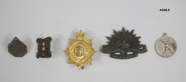 Bendigo Military Museum
Badge - BADGES VARIOUS, 1) Wallace Bishop, 1) 1940, .2) pre 1939, .4) 1939 - 45, .5) 1945
.1) Badge metal 6 sided crown at top, centre has Coat of Arms, one lug on the rear and numbered. .2) Badge pressed brass squarish shape scroll at top and bottom, centre has a figure "8", two lugs on rear. .3) Badge pressed metal gold colour crown at top, centre has letters "ER" surrounded by circles and a wreath, two lugs on rear. .4) Badge pressed metal blackened with Rising Sun depiction crown at top. .5) Badge round silver colour, one side is map of Australia with person over, rear has map depiction of the world..1) On front, "Reserve Occupation", on rear, "A17936", "Issued by the Commonwealth Govt". .2) On front, "8th Aust Inf Regt, cede Nullis". .3) On front, "Royal Australian Army Service Corp". .4) "Australian Commonwealth Military Forces". .5) On one side, "1945", on other, "Victory Medal".badges, uniform, headwear -
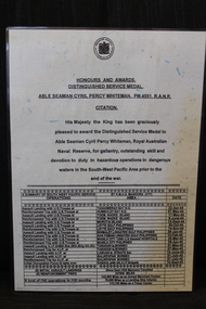 Dandenong/Cranbourne RSL Sub Branch
Document - Citation to PM4551 Able Seaman Cyril Percy Whiteman R.A.N.R, Citation to ABLE SEAMAN CYRIL PERCY WHITEMAN, PM445,R .A. N.R, unknown
WWII historical significanceCitation His Majesty the King has been Graciously pleased to award the Distinguished Service Medal to Able Seaman Cyril Percy Whiteman. the Royal Australian Naval Reserve, for gallantry, outstanding skill and devotion to duty in hazardous operations in dangerous waters in the South-Wes Pacific Area prior to the end of the war. -
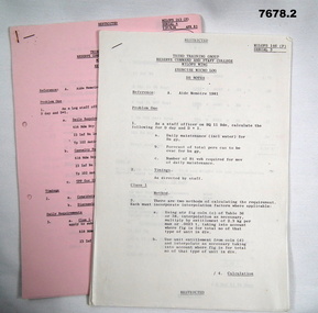 Bendigo Military Museum
Document - TRAINING NOTES, ARMY
1. 'Exercise Micro Log'. Third Training Group, Reserve Command and Staff College, MILOPS Wing. 2. Exercise 'Mini Log.' Part of the Kevin John Herdman, No.397661 collection. See Catalogue No.5942P for details of his service.1. Multipage document on A4 sized paper. Text on one side of each page in black. Pages are cream in colour and stapled together on top LHC. 2. Multipage document on pink coloured A4 paper, Text on one side of each page in black. Pages stapled together on top LHC.2. Handwritten on top RHC of first page; MASTER 81, Sec attached sheets.training notes, exercise microlog, exercise mini log, kevin john herdman -
 Greensborough Historical Society
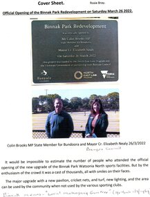
Article - Article and Leaflet, Rosie Bray et al, Official opening of the Binnak Park redevelopment on Saturday March 26 2022, July 2020 , November 2021 and March 2022
An upgrade at Binnak Park Watsonia will improve facilities for the Plenty Valley Cricket Club and Watsonia Sporting Club , which have been displaced from A K Lines Reserve by construction of the North East Link, Binnak Park to continue their activities5 p. comprising 4p. North East Link "Binnak Park Community Update" 2020, with Cover sheet by Rosie Bray and colour photograph of the park at openingbinnak park, banyule parks, binnak park watsonia, north east link -
 Greensborough Historical Society
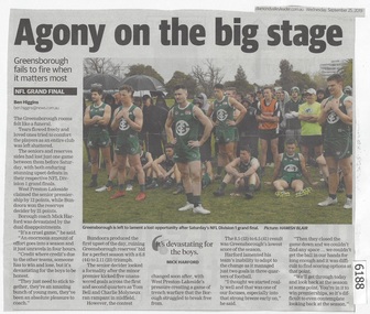
Newspaper Clipping, Diamond valley Leader, Agony on the big stage, 25/09/2019
Greensborough fails to fire when it matters most. The seniors and reserves sides had lost just one game between them before Saturday, with both enduring stunning upset defeats in their respective NFL Division 1 grand finals.News article 1 page, black text.northern football league, greensborough football club, west preston-lakeside football club -
Port Melbourne Historical & Preservation Society
Badge (Item) - Imperial League of Australia Badge, c.1950
The Imperial League of Australia badge returned service badge belonged to Robert Cornelius WATTERS, a member of the Royal Australian Naval Reserve. He served as a Leading Sick Berth Attendant from 11 September 1940 - 21 March 1944.Returned Soldiers Sailors Airmen, Imperial League Australia. 66robert cornelius watters, armed services - navy, royal australian naval reserve, imperial league of australia