Showing 2376 items
matching view st
-
 Stawell Historical Society Inc
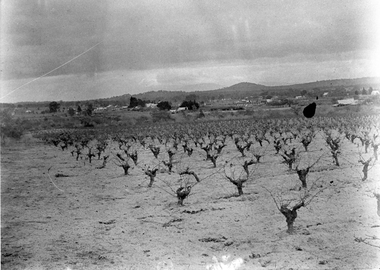
Photograph, View of Great Western, early 1900's
Digital Photo taken from glass slide by Geoff McMillan, Cooper Street Stawell and reproduced as a photo - printed at Stawell Historical Society 2019Black & White Photo - a view from Western View Road, Great Western, looking west over Great Western itself - the back of the Great Western Hall, hotel etc. St Peter's vineyard building near the top right. winery, wine making, panorama -
 Stawell Historical Society Inc
Photograph - View Across to Post Office, Carol Ann Jones, Pizza Roundabout Cr. Main & Wimmera Streets 26th January 2020, 26/1/2020
Roundabout removed on 28th January 2020 by councilRoundabout showing Chemist & Post Office -
Stawell Historical Society Inc
Photograph - View Across to Post Office Arcade, Carol Ann Jones, Pizza Roundabout Cr. Main & Wimmera Streets 26th January 2020, 26/1/2020
Roundabout removed on 28th January 2020 by councilRoundabout showing Post Office Arcade -
Stawell Historical Society Inc
Photograph - View Upper Main Street Looking East, Carol Ann Jones, Pizza Roundabout Cr. Main & Wimmera Streets 26th January 2020, 26/1/2020
Roundabout removed on 28th January 2020 by councilRoundabout showing Post Office and Arcade -
 Stawell Historical Society Inc
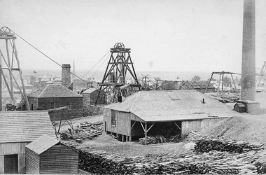
Photograph, Scotchmans United Quartz Mining Company Scene c1890's. Same as 2640
Scotchmans United Quartz Mining Company Shaft was 1,018 feet deep.Stawell Mining Scene from Big Hill. Close up view of the winding engine shed Poppet Head and Building Scotchman's United Mine. Rear poppet head Crown Cross. Upper Main Street visible left Back of Photo. Stawell 176 Miles from Melbournemining, panorama -
Stawell Historical Society Inc
Print, The Picturesque Atlas of Australia, Coloured Wood Engraving of Stawell c 1866 Published in "The Picturesque Atlas of Australasia", 1886
Prepared to celebrate the centenary of Australian settlement since the arrival of the First FleetColoured print of Stawell. View from Big Hill by Hy Fulwood Circa 1866panorama, mining -
 Stawell Historical Society Inc
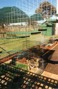
Photograph, I can also ignore you as well for I have a 360 view
Catnip Modular Pet Park Stawell. Eight colour photographs and paper clipping.stawell -
 Stawell Historical Society Inc
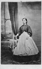
Photograph, Mary Ann Hart -- Studio Portrait
From Chapman Family AlbumSepia studio window view. Holding book by spine.Mary Ann Hart Oley/Uley Plains -
Stawell Historical Society Inc
Photograph, Stawell Industrial Area Aerial View with the Woollen Mills, Stawell Timber Industry & Pleasant Creek Hospital
Aerial Photograph Woollen Mills, Stawell Timber Industry, Pleasant Creek Hospital, Oval,.industry -
Stawell Historical Society Inc
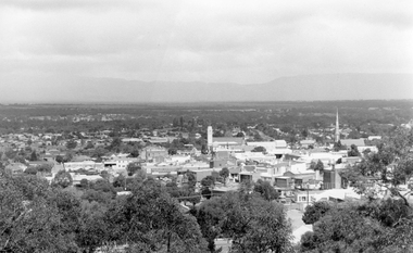
Photograph, Greg Robson, View of Stawell 2019
Stawell from the top of the Stawell Fire Brigade Bell Tower Saturday May 4th 2019view, streetscape -
Stawell Historical Society Inc
Photograph, Carol Ann Jones, Adobe brick building Great Western
Adobe Kitchen located corner of Western View Rd and Hurley's Lane. The original House is gone. Building being restored as a B&B -
 Stawell Historical Society Inc
Photograph, View of Stawell from Big Hill
... Stawell Historical Society Inc 46 Longfield St Stawell ... -
Stawell Historical Society Inc
Photograph, Stawell Technical School -- Aeriel View 1967, 5/6/1967
Five black and white photographs - Aerial view showing Stawell Technical School students on oval form initials sts -
Stawell Historical Society Inc
Map, Crocodile Gold Corp, Photographic Aerial View of Big Hill showing underground workings and surface workings and proposed Big Hill Open Pit proposal, December 2014
Crocodile Gold Corp SGM photo Map showing Magdala Decline& Wonga Decline December 2014 Produced for Public Consultation over Big Hill Open Pit Proposal. Aerial Views Stawellmining, gold, map -
Stawell Historical Society Inc
Map, Stawell Gold Mine, Stawell Gold Mine Photo Map of Stawell Township showing Underground Declines in mining lease, 2007
SGM photo Map 2007 Produced for Public Consultation over Big Hill Open Pit Proposal. Aerial Views Stawellmining, gold, map -
 Stawell Historical Society Inc
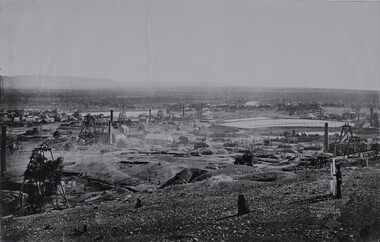
Photograph, View of Stawell from Big Hill 1874 photo showing mines at North end of Stawell -- Looking towards Briggs Bluff -- 2 Photos
Black and White photograph of Stawell from Big Hill with mining in foreground and Moonlight evaporation dams. Holtermann photograph Taken April 1874mining, panorama -
 Stawell Historical Society Inc
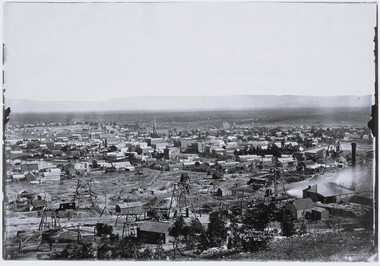
Photograph, View of Stawell from Big Hill April 1874 showing mines centered on north end of Main Street -- 2 Photos
From left Shire Hall Pleasant Creek in distance, Mathers & Franklin, Stawell Coach Factory, Coffee Palace, Christ Church of England Church Hill, Mechanics Institute, Temperance Hotel, Matherson Cross Reef Hotel.Black and White Holtermann photograph of Stawell from Big Hill with mining in foreground. 1874 Site of fire in Main and Street Patrick Street 22 April 1874 visible in centre of photograph.mining, panorama, streetscape -
 Stawell Historical Society Inc
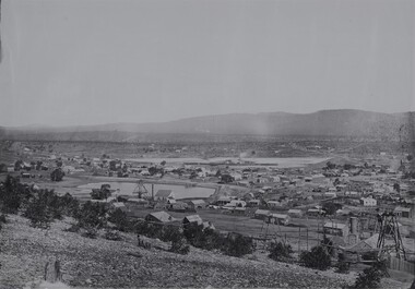
Photograph, View of Stawell from Big Hill 1874 showing mines looking towards South end of Black range -- 4 Photos
Visible Nelsons Criterion Hotel, Wimmera Crushing Mill, Odd Fellows Arms hotel, F.H. Oliver & Co Grain Merchant, Reefs Restaurant.Holtermann Black and White photograph of Stawell from Big Hill with mining in foreground. April 1874. Wimmera Crushing Mill and settling pond at centre of photograph. Stawell water supply centre left of photo. Black Range in Background.mining, panorama -
Stawell Historical Society Inc
Map, MPI Mines, Plan View of Township Area 2003, 13/6/2003
goldShowing known gold workings & Houses Stawell Gold Mines. 13 June 2003 1 : 7500 MPI Minesmining -
Stawell Historical Society Inc
Map, MPI Mines, Plan View of Township Area 2003, 13/6/2003
goldShowing known old gold workings Stawell Gold Mines. 13 June 2003 1 : 7500 MPI Minesmining -
Stawell Historical Society Inc
Map, Western Mining Corp / Stawell Joint Venture, Three dimensional View of Wonga Open Cut & Decline, April 1992
Cutaway perspective showing DeclinesView Looking North West with Cut Away Showing Underground Development Floorplanmining, gold -
Stawell Historical Society Inc
Map, Stawell Gold Mine, Three dimensional View of Magdala Decline, March 1994
View of Mine looking from Stawell Hospital towards Big Hill Levels indicate depth in metres below hillParallel View Scale 1 : 2600mining, gold -
Stawell Historical Society Inc
Map, Stawell Gold Mine, Perspective View Magdala Decline August 1989, August 1989
Shows Mining Levels Drawn By D. Bosher Stawell Joint Venture Victoria SJVmining, gold -
 Stawell Historical Society Inc
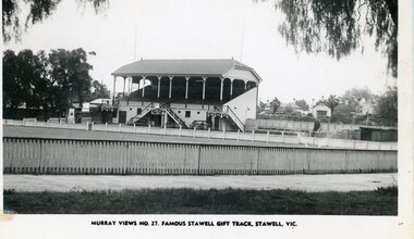
Photograph, Stawell Gift Athletics Track at Central Park with the No1 Grandstand 1930 -- Postcard
Postcard Murray Views No. 27. Famous Stawell Gift Track Stawell Vic c1930 Central Park. No1 Grandstand.stawell -
 Stawell Historical Society Inc
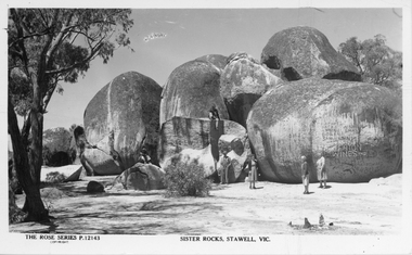
Photograph, Sister Rocks -- Postcard Rose Series
Postcard of Sister Rocks Stawell. Rose Series P.12143. c 1940's view with 6 people around the rocks.Sister Rocks Stawell "The Rose Series". 5 people standing around the rocks and one sitting on one of the large rocks. c 1940'sThe Rose Series P.12143 copyright. Sister Rocks. Vic.stawell tourism -
 Stawell Historical Society Inc
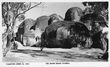
Photograph, Sister Rocks -- Postcard Valentine Series No 1084
Postcard Valentine Series No 1084. Sister Rocks Stawell. c 1940'sPostcard of Valentine Series 1084. The view of the Sister Rocks looking South. c 1940'sValentine Series No 1084 The Sister Rocks Stawell on the front. On the back Valentine Publishing Co Melbourne & Sydneystawell tourism -
 Stawell Historical Society Inc
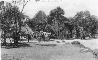
Photograph, Sister Rocks looking East
Sister Rocks Stawell. Man Standing, lady in 4 wheel buggy, man on horse and children in background. View showing trees around the rocks.Black & White photocopy of Sister Rocks, Stawell. looking East. c 1900Sister Rocks, Stawellstawell scene -
 Stawell Historical Society Inc
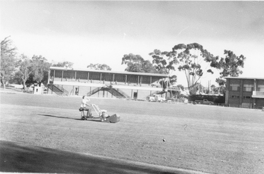
Photograph, Central Park Oval c 1980
c 1980 Parks and garden staff mowing Central Park Oval. No 2 Grandstand has its roof on. Also at the right end of the Grandstand is the Railway foot bridge which was demolished in 1991.. The Football Clubrooms built in mid 1960's is just in view on the right side. Photo of oval with garden staff mowing. No 2 Grandstand and just a section of the Football Clubhouse in view. c 1980'sstawell sports -
 Stawell Historical Society Inc
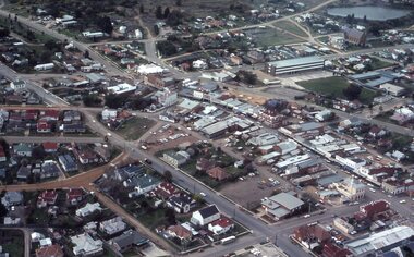
Photograph - Slides, Ian McCann, Aerial View 1976, 1976 - 1984
Aerial Colour Photograph of Stawell -
 Stawell Historical Society Inc
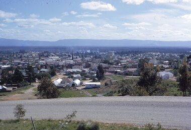
photograph - Slides, Ian McCann, View from Big Hill looing West?, 1976 - 1984
Clour Photograph of the view looking across Stawell towards the Grampians.