Showing 315284 items
matching 11-paxton-street-east-malvern-melbourne-australia
-
 4th/19th Prince of Wales's Light Horse Regiment Unit History Room
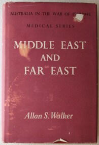
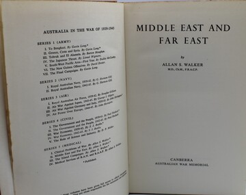
Book, Australian War Memorial, Australia in the War of 1939-1945, Series Five, Medical, Volume II, Middle East and Far East, 1962 (reprint)
Hard covered book of 701 pages with photos, diagrams and mapsbook, medical services, ww2, book, medical services, ww2 -
 Ringwood RSL Sub-Branch
Book, Australia in the War of 1939 - 1945. Middle East and Far East, 1953
Official history no dust cover -
 Ringwood and District Historical Society
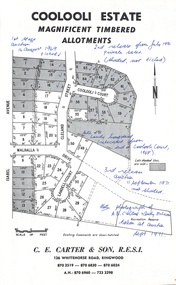
Document - Folder, Coolooli Estate Subdivision, Ringwood East, Vic. - Four Releases 1969-1975
Collection of Subdivision Plans, Land Sale flyers, Auction notices, and Real Estate Agent's notes for Coolooli Estate, Ringwood East, Victoria. Subdivision includes Coolooli Court, Isabel Avenue, Walhalla Drive, Cleland Street, Landell Court, Byways Drive, Heathwood Street and Hume Street, released over four stages - First Stage auction 16 August 1969, Second Release private sales from July 1970, Third Release Auction 11 September 1971, Final Release auction June 21st 1975. Agents - C.E. Carter & Son, 126 Whitehorse Road, Ringwood until moving to 122 Whitehorse Road in 1973 - Tel. 870 6024, 870 6830, 870 2519, A.H. 723 3298, 870 6960. Digitised copy of photograph - A.B. Carter and Andy McLean at Coolooli Estate auction, 11 September, 1971. -
 Kew Historical Society Inc
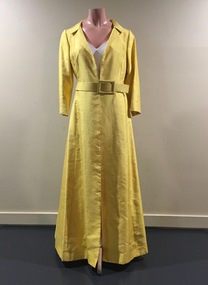
Clothing - Yellow Silk Evening Coat, 1960s
Jinoel of Melbourne was a highly successful Australian fashion house launched by Jill and Noel Kemmelfield in 1957. Eleven years later the designers won the [Melbourne] Gown of the Year award. Jill and Noel Kemmelfield were later to launch Marty and Martine, their mid-market labels. They closed their business in the 1980s. The evening coat was owned, worn and donated by Dione McIntyre.The McIntyre Collection of clothing and clothing accessories forms one of the largest single donations to our Fashion & Design collection. It includes clothing and clothing accessories worn by four women in the Cohen and McIntyre families across three generations. The items worn by Melbourne architect, and Kew resident, Dione McIntyre date from the 1960s and 1970s, and include evening wear, day wear, hats and shoes. As Dione McIntyre often accompanied her husband, fellow architect Peter McIntyre, to formal events, there are a number of pieces of evening wear among the items. The McIntyre Collection also includes items worn by women of an earlier generation: by Lilian Cohen, Dione McIntyre's mother, and by her mother-in-law, the wife of the architect Robert McIntyre. At the other end of the chronological spectrum are a number of outfits belonging to, worn and donated by Annie McIntyre. These include outfits created by notable late 20th century Australian and/or international fashion designers. The McIntyre Collection is significant historically and artistically as it includes examples of design that demonstrate changing tastes in fashion over an 80-year period. The collection is also significant in that it includes the work of a large number of Melbourne designers from the 1960s to the 1990s. Long sleeved full length yellow raw silk evening coat fastened with a belt of the same colour and fabric. Designed by Jinoel of MelbourneLabel: Jinoel of Melbournewomen's clothing, jinoel of melbourne (vic), coat dresses, jill & noel kemmelfield, mcintyre collection, australian fashion - 1960s -
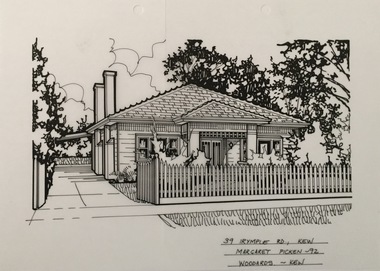 Kew Historical Society Inc
Drawing - Property Illustration, Margaret Picken, 39 Irymple Avenue, Kew East, 1992
After training as a Cartographic Draftsman within the mining industry, I worked as a property illustrator for real estate firms in the eastern suburbs of Melbourne for 23 years from 1983. I initially photographed houses with a Polaroid camera and made a 'thumbnail' sketch while there. The photos were used to scale off a sketch in pencil and then that sketch was overlaid with drafting film and the 'pen and ink' completed. The pens I used were the Rotring ‘Rapidigraph’ drafting pens. The ink was also made by Rotring (German).The film was ‘Rapidraw’, polyester drafting film, double matte. It takes a very fine line and doesn’t bleed. As well as house sketches, there were often floor plans and site plans ordered. Aerial sketches were ordered when the property needed an overall view. (Margaret Picken, 2020)This drawing is one of a series created by Margaret Picken for a number of real estate agents in Melbourne between 1983 and 2005. Each work is signed and dated by the artist.Gift of Margaret Picken, 2020Pen and ink architectural drawing on drafting film of 39 Irymple Street, Kew East by Margaret Picken.39 IRYMPLE RD., KEW / MARGARET PICKEN '92 / WOODARDS ~ KEWartist -- margaret picken 1950-, architectural drawings -- houses -- kew (vic.), 39 irymple avenue -- kew east (vic.) -
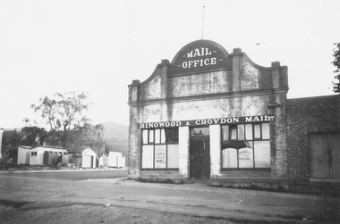 Ringwood and District Historical Society
Photograph, Adelaide Street, Ringwood, showing 'Mail' Office - looking east. Demolished for Eastland parking area. Photograph circa early 1960s
Catalogue card reads, "Adelaide St. showing 'Mail' Office - looking east. Demolished for Eastland parking area". -
 Eltham District Historical Society Inc
Photograph, Looking north along the east side of Main Road from near Henry Street, Eltham, February 1968, Feb 1968
Shows the Commercial Bank of Australia on the Dudley Street intersection and part of the War Memorial on the left amongst the parked cars.In February 1968 an unknown person took a series of photos from the Eltham Hotel at Pitt Street heading north along Main Road through the shopping centre to just north of Elsa Court covering the length of the section of Main Road which was duplicated shortly thereafter. Shows the condition and environment of the streesscape of Main Road, Eltham immediately prior to the duplication between Pitt Street and Elsa Court through the shopping centre. Also shows a number of shops and businesses that operated at that time.Black and white photographduplication, eltham, main road, commercial bank, eltham, dudley street, shire of eltham war memorial, arthur street, shopping centre, eltham shire office -
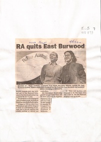 Whitehorse Historical Society Inc.
document - Article, RA quits East Burwood, 17/08/1994
Article on ' Radio Australia quits Burwood'.Article in Nunawading Post about the move of Radio Australia from East Burwood to Southbank, Melbourne. They have been broadcasting for the last 12 years (1982 - 1994). They broadcast in 9 languages to about 50 million people in South East Asia and Pacific region. The East Burwood property is up for sale.Article on ' Radio Australia quits Burwood'.radio broadcasting, radio australia, white, derek, australian broadcasting commission, burwood east, southbank, melbourne -
 Melbourne Tram Museum
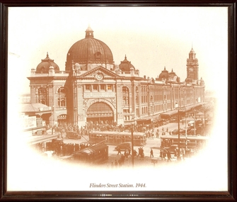
Photograph - Framed Photographs, Malvern Framing Gallery, "Flinders Street Station 1944", late 1920s
Taken from St Paul's Cathedral steps. Has a small part of the Princes Bridge Station building on the left hand side. The Swanston St canopy of Flinders St station has the words "Cross Crossings Cautiously". A W class tram is northbound while an S or T class tram is southbound while another single trucker is west bound to Spencer St in Flinders St. The trams in the photo were used prior to 1944. All W class trams were converted to W2 class prior to 1944 and the single trucker westbound had been scrapped by then. Photo dated late 1920s.Yields information about the intersection of Flinders and Swanston Sts late 1920s.Reproduced photograph, sepia-toned titled "Flinders St Railway Station 1944' in a brown wooden frame with a gold line, paper backed with a cotton hanging strip. On rear in ink at the top - "Donated to Hawthorn Tram Museum Feb. 19th 2012 Ron Scholten"trams, tramways, melbourne, flinders st station, w class, s class -
 Melbourne Tram Museum
Document - Tender Document, Melbourne & Metropolitan Tramways Board (MMTB), "Purchase from the Board or Eleven (11) Second-hand W2 Type Tram bodies", Sep. 1978
Tender document - Tender "O" 594 - single foolscap duplicated sheet titled "Purchase from the Board or Eleven (11) Second-hand W2 Type Tram bodies", giving details of the tram numbers and some dimensions. Document refers to attached conditions, but no attachments. Tenders closed 20/9/1978. Trams: 359, 412, 424, 448, 527, 536, 550, 559, 585, 590 and 628.On rear in pencil re tram 386 going or gone to Sunbury Hospital.trams, tramways, mmtb, tramcars, tenders, sales items, tram 359, tram 412, tram 424, tram 448, tram 527, tram 536, tram 550, tram 559, tram 585, tram 590, tram 628 -
 Greensborough Historical Society
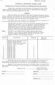
Article - Article and Leaflet, Rosie Bray et al, Official opening of the Binnak Park redevelopment on Saturday March 26 2022, July 2020 , November 2021 and March 2022
An upgrade at Binnak Park Watsonia will improve facilities for the Plenty Valley Cricket Club and Watsonia Sporting Club , which have been displaced from A K Lines Reserve by construction of the North East Link, Binnak Park to continue their activities5 p. comprising 4p. North East Link "Binnak Park Community Update" 2020, with Cover sheet by Rosie Bray and colour photograph of the park at openingbinnak park, banyule parks, binnak park watsonia, north east link -
 City of Moorabbin Historical Society (Operating the Box Cottage Museum)
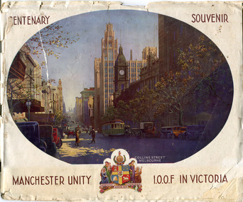
Booklet - Centenary Souvenir - Manchester Unity I.O.O.F in Victoria, IOOF Melbourne, 1934
A booklet issued by The Grand Master and Board of Directors M.U.I.O.O.F. in Victoria and compiled by W .H. Best, Grand Secretary printed in the year the City Of Melbourne began the celebration of its Centenary (1934). The booklet is about the history of Manchester Unity I.O.O.F. and the building of their Gothic building, known as the Manchester Unity Building on the corner of Collins and Swanston Streets, Melbourne. The booklet also contains many advertisements from firms who supported the compiling and publishing of the document.Many of the families living in the City of Moorabbin were members of Manchester Unity I.O.O.F. Victoria.A booklet with 40 pages printed in black and white, contents include story of the building of the Manchester Unity Building on the corner of Collins Street and Swanston Street. Advertisements of various businesses in Melbourne. Coloured Cover with a view of Collins Street.CENTENARY SOUVENIR/ PHOTO of Collins St Melbourne, / MANCHESTER UNITY / Crest of Arms/ I.O.O.F IN VICTORIAmanchester unity i.o.o.f. victoria, manchester unity building, collins street, swanston street -
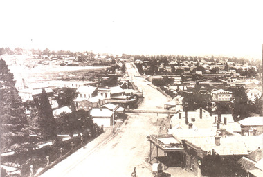
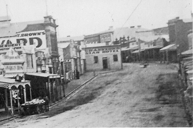 Stawell Historical Society Inc
Photograph, Enlargement of Catalogue number 0541 of Main Street looking East featuring the Star Hotel, 1890's
Enlargement of right hand side of photo 0541. Top end of Main St. looking East towards Big Hill. From left Herbert Photographic, T Brown, Star Hotel on bend jutting out into middle of road. Mechanics Institute in background. Two Horse wagon in street on left.stawell businesses streetscape -
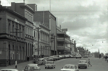 Federation University Historical Collection
Photograph, Geoffrey Biddington, Lydiard Street South, Ballarat Looking East, 1967
Black and white image of Ballarat's Sturt Street.ballarat, bridge street, amp, anz bank, george hotel, lydiard street north -
 Federation University Historical Collection
Plan, Barkly Street Campus, Ballarat East, c1950s ?
Ink on paper plan: Barkly Street Campus. plans, barkly street campus, ballarat east, ballarat girls', ballarat girls' secondary school -
 Ringwood and District Historical Society
Photograph-B&W, Joan Walker, East Ringwood 2000- Railway Avenue looking West opposite the Railway Station, 2000
East Ringwood 2000- Railway Avenue looking West opposite the Railway Station- B&W Photo from Album 6501 -
 Ringwood and District Historical Society
Photograph-B&W, Joan Walker, East Ringwood 2000-Railway Crossing and the corner of Dublin Road & Railway Avenue, 2000
East Ringwood 2000-Railway Crossing and the corner of Dublin Road & Railway Avenue- B&W Photo from Album 6501 -
 Ballarat Heritage Services
Image, View of Ballarat East from from the Fire Brigade Tower, c1895, c1895
Black and white image of the view of Ballarat East along Main Road. The photograph was taken from the Ballarat Fire Brigade Tower.ballarat east, main road ballarat east, ballarat fire brigade, phoenix hotel -
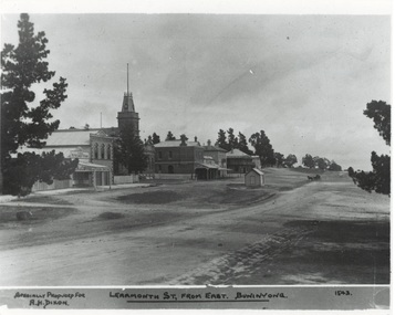 Buninyong & District Historical Society
Photograph - Original Photograph, Learmonth St from the east, Town Hall Precinct, early 1900's, 9/11/1991
historic buildingsB/W photograph, Learmonth St from the east, Town Hall Precinct, early 1900's, Refreshment Rooms, Fire Station, Town Hall, Whyke's Butchers, Allan's Store, Bank, Buninyong Inn, toll booth."Specially Produced For A.H. Dixon Learmonth St, from east, Buninyong 1543"buninyong, calf's refreshment rooms, fire station, town hall, whyke's butches, allan store, nab bank, buninyong inn, toll booth -
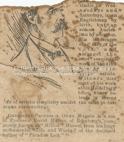 Eltham District Historical Society Inc
Newspaper - Newspaper Clipping, Melbourne Punch, Artist Walter Withers, PEOPLE WE KNOW, Melbourne Punch, June 17, p. 2, 1897
ARTIST WALTER WITHEBS, whose pictures are now on exhibition at his Melbourne studio on Wednesdays and Saturdays, is an Englishman by birth, but an ardent Australian by adoption. His landscapes are "racy of the soil,” and amongst the most successful work of the kind done by Victorian artists. Withers does most of his work at his Heidelberg home, where he leads a serene life of artistic simplicity amidst the most picturesque surroundings. PEOPLE WE KNOW (1897, June 17). Melbourne Punch (Vic. : 1855 - 1900), p. 2. Retrieved August 22, 2023, from http://nla.gov.au/nla.news-article174626232Journal inscribed: "Mrs Withers 463 Collins St. West Melbourne"art exhibition, art review, john withers collection, melbourne, walter withers studio, 463 collins street west, walter herbert withers, artist -
 Eltham District Historical Society Inc
Book, Melway Great Melbourne street directory including Geelong, Phillip Island Healesville, Bellarine & Mornington Peninsulas, 1998
25th edition. Coloured detailed maps accessed by a street or location index. Cover: (Includes) New Southbank map including Crown Complex, enlargements of Footscray and Kensington, bike paths, walking tracks & horse trails, latest public transport information, South east Australia tours maps, Vic Roads new route numbers, map of Australia1 atlas (22, 772 p.) : col. maps ; ISSN 03113957streets, maps, roads, melbourne -
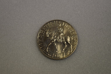 Warrnambool and District Historical Society Inc.
Coin, Queen Elizabeth 11 Silver Jubilee
This is a British coin to the value of 25 newpence. It is a commemorative coin to celebrate the 25th anniversary of Queen Elizabeth's ascension to the throne of England.This coin has no local provenance but is of interest as a British commemorative coin of 1977.Circular silver coin with a reeded edge The obverse depicts a raised profile figure of Queen Elizabeth 11 mounted side saddle on a horse and text. (It is reminiscent of the Queen at the Trooping of the Colour.) The reverse features a crown , an eagle with outstretched wings on a dais, decorative leaves and berries. QUEEN ELIZABETH. 11 DG REG FD . 1977queen elizabeth 11 -
 Tatura Irrigation & Wartime Camps Museum
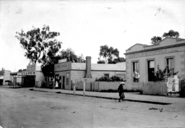
Photograph, Commercial Bank of Australia
Features R-L: Commercial Bank of Australia, C. Mitchell Newsagency, Charles Brady Draper. East end of Hogan Street. Features a girl child crossing the street; womand and child at newsagent's shopfront.tatura, buildings, historic, costume, children, female -
 Ballarat Heritage Services
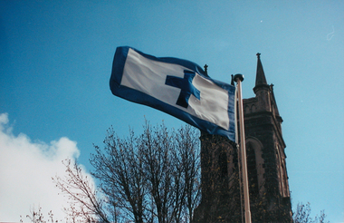
Photograph - Colour, Flag of St Alipius', Ballarat East, 2004, 23/09/2004
"Centenary of Fnrst Mass at Ballarat Friday last marked the centenary of the arrival of the first priest and the celebration of the first Mass in Ballarat. The Rev. Patrick Dunne reached the diggings on October 17, and on Sunday, October 19, 1851, in a bark hut near Brown Hill, he celebrated Mass. Worshippers had to kneel on quartz gravel. The weather had been the worst experienced in Victoria for a number of years, and most of the creeks between Melbourne and Ballarat were flowing torrents, but Father Dunne (who came from the Coburg mission), carrying the barest necessities and the sacred vestments, set out for Ballarat on horseback. He had to ford and swim his horse across the creeks. When most of his congregation left for the Castlemaine diggings Father Dunne returned to Melbourne. In August, 1852, Rev. Matthew Downing became Ballarat's first resident priest. He built a large wooden structure with a canvas roof which served as a church, but later erected at the Gravel Pits the first permanent church. This church was the largest of any house of worship on any goldfield in the colony. It cost £ 100, contributed solely by Father Downing and his flock. Soon after he got the authorities to survey a large piece of land at the back of the township as a burial ground and procured a grant of £500 for fencing it. A grant of £250 was also obtained for the improvement of the chapel and fittings of a school, where Michael Campion Carey opened the first school. Rev. Patrick Smyth succeeded Father Downing, who was followed by Rev. P. Madden, who in 1857 began to plan the erection of St. Patrick's Church. The foundation stone of this was laid by Bishop Goold on February 12, 1858, and the church was opened for the first time on November 8, 1863." (Melbourne Advocate 25 October 1951)Two colour photographs showing the St Alipius' Catholic Church flag - a blue cross and border on white. st alipius, church, ballarat east, flag -
 Surrey Hills Historical Society Collection
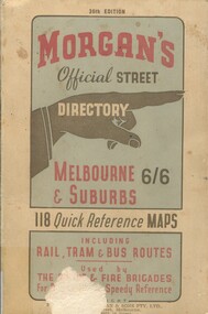
Book, Morgan's Official Street Directory, c1940s
incl.index. This Street Directory of Melbourne and suburbs, c1940s, includes a list of suburbs, their mileage from the city and how to reach them; an index to localities as well as the index to streets appearing on the maps. It also shows bus routes, railways and tramways routes on the maps.incl.index. This Street Directory of Melbourne and suburbs, c1940s, includes a list of suburbs, their mileage from the city and how to reach them; an index to localities as well as the index to streets appearing on the maps. It also shows bus routes, railways and tramways routes on the maps.melbourne metropolitian area, suburbs, cities and towns, maps -
 Kew Historical Society Inc
Plan, Melbourne & Metropolitan Board of Works : Borough of Kew : Detail Plan No.1574, 1905
The Melbourne and Metropolitan Board of Works (MMBW) plans were produced from the 1890s to the 1950s. They were crucial to the design and development of Melbourne's sewerage and drainage system. The plans, at a scale of 40 feet to 1 inch (1:480), provide a detailed historical record of Melbourne streetscapes and environmental features. Each plan covers one or two street blocks (roughly six streets), showing details of buildings, including garden layouts and ownership boundaries, and features such as laneways, drains, bridges, parks, municipal boundaries and other prominent landmarks as they existed at the time each plan was produced. (Source: State Library of Victoria)This plan forms part of a large group of MMBW plans and maps that was donated to the Society by the Mr Poulter, City Engineer of the City of Kew in 1989. Within this collection, thirty-five hand-coloured plans, backed with linen, are of statewide significance as they include annotations that provide details of construction materials used in buildings in the first decade of the 20th century as well as additional information about land ownership and usage. The copies in the Public Record Office Victoria and the State Library of Victoria are monochrome versions which do not denote building materials so that the maps in this collection are invaluable and unique tools for researchers and heritage consultants. A number of the plans are not held in the collection of the State Library of Victoria so they have the additional attribute of rarity.Original survey plan, issued by the MMBW to a contractor with responsibility for constructing sewers in the area identified on the plan within the Borough of Kew. The plan was at some stage hand-coloured, possibly by the contractor, but more likely by officers working in the Engineering Department of the Borough and later Town, then City of Kew. The hand-coloured sections of buildings on the plan were used to denote masonry or brick constructions (pink), weatherboard constructions (yellow), and public buildings (grey). This plan shows several very large houses, particularly along Glenferrie Road, and the area now occupied by Ruyton Girls’ School. ‘Tarring’ (incorrectly spelled here as ‘Karring’) was built for Henry Henty in 1872, on part of his original allotment of 20 acres, and ‘Mount View’, which retains its original building and the fountain in the front garden, is part of Ruyton’s Junior School. The most significant change to Tarring and its grounds since 1903, involve the removal of a number of the outbuildings, including a Burmese temple, bought by Henty from the Burmese Exhibit at the Great Exhibition of 1880. It is shown on the plan as a summerhouse. The two-storey mansion, on the corner of Glenferrie Road and Wellington Street, was built in 1891 by leading architect Alfred White as his own home. Having an initial N.A.V. of £160, the house was purchased by a warehouseman Henry Lister, by 1900, when the N.A.V. was recorded at £111. By the turn of the century the house was known as ‘Comaques’. By contrast, much smaller houses are shown in Scott and Byron Streets, including a tiny Mission Hall in Byron Street, which belonged to the Anglican Church from at least 1903 to 1917.melbourne and metropolitan board of works, detail plans, maps - borough of kew, mmbw 1574, cartography -
 Bendigo Military Museum
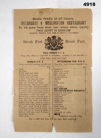
Flyer - MENU, RESTAURANT, Melbourne & Wellington Restaurant, Melbourne and Wellington Restaurant, 23 Nubar Pasha Street. Cairo, c1914 - c1943
Of interest below the title of the restaurant are the words "This joint is Dinkum"". "Special prïces for glorious soldiers.This is a breakfast menu for this Cairo Restaurant. The paper is light brown, the printing is in black ink. There is th U.K. Coat of Arms, displayed above the menu and prices. It also has a few small lines for full dinner, dinner, afternoon tea.There is nothing printed on the back of the sheet.cairo, menu, food, restaurant -
 Melbourne Legacy
Document - Minutes, Minutes of Inaugural meeting of Intermediate Legacy Club (Girls) held at 45 Market Street, Melbourne, on 17th August, 1955, commencing at 8 p.m, 17/08/1955
The Intermediate Legacy Club was a Club comprised of ex-Junior Legacy Girls who had attended the Physical Culture Classes (the classes commenced in 1927). The Intermediate clubs were aimed at children who were older than 16 years of age.Demonstrates the strong bonds formed amongst the Junior Legacy children and the desire to be of service in their turn to Legacy beneficiaries.White foolscap paper with black type x2 sheets, printed both sides. 2 copies.girls' classes, ilc, junior legatee -
 Ballarat Tramway Museum
Document - Table Cards, Melbourne and Metropolitan Tramways Board (MMTB), 1979 Australia Day (29/1/1979) Cavalcade, Jan. 1979
Yields information about the arrangements for the Australia Day Cavalcades and the way crews were arranged.Heavy card printed as a M&MTB driver run table used for the 1979 Australia Day (29/1/1979) Cavalcade with BTPS tram No. 14. Gives time ex Preston and times ex Spencer & LaTrobe and ex Swanston and car in at Preston depot. In blue and red ink. Image of items added 2/11/13.trams, tramways, mmtb, btps, melbourne, australia day -
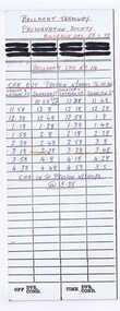
 Ballarat Tramway Museum
Document - Table Cards, Melbourne and Metropolitan Tramways Board (MMTB), Australia day (26/1/1980) cavalcade, Jan. 1980
Yields information about the arrangements for the Australia Day Cavalcades and the way crews were arranged.Heavy card printed as a M&MTB Driver's table, used for the Australia day (26/1/1980) cavalcade for BTPS No. 40. Gives time ex Preston, Spencer St (Flinders St.) and ex Simpson St shunt and times back to Preston workshops. In blue and red ink. Image of items added 2/11/13.trams, tramways, mmtb, btps, melbourne australia day