Showing 2608 items matching "aerial"
-
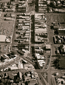
 Port Melbourne Historical & Preservation Society
Photograph - Aerial view of Port Melbourne, c. 1990
Notations made as a result of conversations Anne had in the early 1990's with an elderly male resident of Port Melbourne.Map and aerial photo of Port Melbourne with handwritten annotations detailing the location of various buildings, trotting tracks, etc which previously existed in Port Melbourne (recollections only).fishermans bend -
Tatura Irrigation & Wartime Camps Museum
Photos
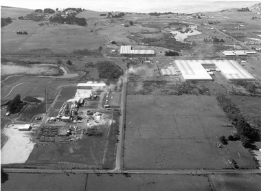
Borrowed photos of building of Goulburn Murray Water Offices c.1990. Includes original site (Tatura State School) in Casey Street, aerial photos and staff at opening. -
 Bendigo Historical Society Inc.
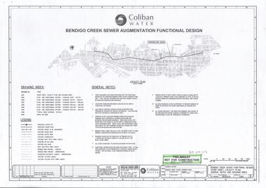
Document - COLIBAN WATER - BENDIGO CREEK SEWER AUGMANTATION FUNCTIONAL DESIGN
Design for Coliban Water proposed new sewer. Bendigo creek sewer augmentation functional design dated 29/08/2003. Also eight aerial photos of the area.bendigo, business, coliban water -
Canterbury History Group
Ephemera - Magic of Maling Road, 1/02/2011 12:00:00 AM
Real estate advertisement from the Weekly Review for the auction on 12 March 2011 of 29 Maling Road Canterbury. Includes coloured photographs of the exterior and an aerial view of the site.canterbury, maling road, land sales -
 Port Fairy Historical Society Museum and Archives
Photograph, 1940's
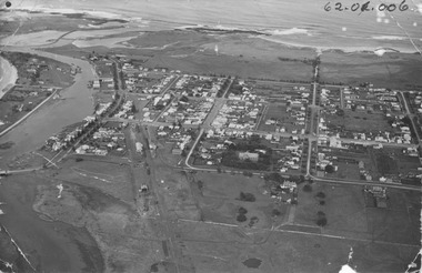
The photograph depicts the river, bridge, rail line, Regent Street, Sackville Street, William Street and south west passage and pudney groundsSignificant for its depiction of the layout of the town in the 1940's and the river and south west passageBlack and white photograph Oblique Port Fairy Streets looking SouthALEX WILKINS PHOTOGRAPHER WARRNAMBOOL O.G.Powell Chemist Phone 88 Port Fairy Handwritten- Aerial View to be enlarged to 12" wide underlined 62.01.006 written on front of picturemoyne river, sackville street, william street, south west passage, pudney gorunds -
 Eltham District Historical Society Inc
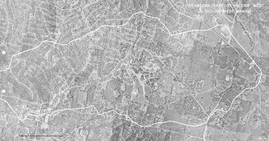
Work on paper (Sub-Item) - Photograph, St Helena East, St Helena West and Eltham West drains, ca 1980
black and white aerial photograph with boundary and drains marked over three page fold out eltham, st helena, drains, aerial view -
Tatura Irrigation & Wartime Camps Museum
Book, Birchip, Essays on a Shire, 1970
To record history of Birchip Shire for 75th Anniversay. Includes fold out aerial map of town.Cream and brown covered book, photographs of old shops on coverbirchip shire -
 City of Ballarat Libraries
Photograph - Card Box Photographs, Ballarat High School circa 1960
Aerial view of the Ballarat High School site Gilles Street. Notice the re-locatable classrooms.ballarat high school, gillies street, education, building, streetscape, public -
 Parks Victoria - Wilsons Promontory Lightstation
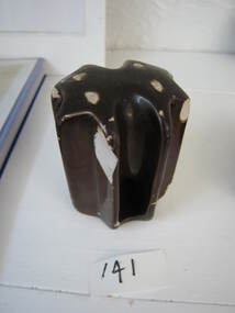
Insulator
Used on radio aerial installation during the period that the RAAF were based at the Lightstation. 1942 - 1946This technical item has second level significance because it's use is likely to be directly linked to WWII communications activity at the lightstation: Small brown glazed ceramic insulator. The shape is similar to a door knob. -
 Federation University Historical Collection
Photograph, Students on the Gippsland Campus, 2004
In 1989 Monash University took over the Gippsland Institute of Advanced Education to create Monash Gippsland Campus. In 2014 the University of Ballarat and the Churchill Campus of Monash University merged to become Federation University Australia.Photograph of the Federation University Gippsland Campus during its era as a campus of Monash University. gippsland campus collection, monash university gippsland campus, churchill, aerial, alumni -
 Federation University Historical Collection
Photograph, Vincent on the Gippsland Campus, 2004
In 1989 Monash University took over the Gippsland Institute of Advanced Education to create Monash Gippsland Campus. In 2014 the University of Ballarat and the Churchill Campus of Monash University merged to become Federation University Australia.Photograph of the Federation University Gippsland Campus during its era as a campus of Monash University. gippsland campus collection, monash university gippsland campus, churchill, aerial, alumni -
 Ballaarat Mechanics' Institute (BMI Ballarat)
Aerial view of Bridge Mall & Bakery Hill, Max Harris
This photograph is from the Max Harris Collection held by the Ballaraat Mechanics' Institute. Please contact BMI for all print and usage inquiries.ballarat, bridge mall, bakery hill, 1980s, aerial -
 Ballaarat Mechanics' Institute (BMI Ballarat)
Aerial view of Bridge Mall area, Max Harris
This photograph is from the Max Harris Collection held by the Ballaraat Mechanics' Institute. Please contact BMI for all print and usage inquiries.ballarat, bridge mall, bakery hill, 1980s, aerial -
 Ballaarat Mechanics' Institute (BMI Ballarat)
Aerial Bridge Mall modern aerial shot 1980's
This photograph is from the Max Harris Collection held by the Ballaraat Mechanics' Institute. Please contact BMI for all print and usage inquiries.ballarat, aerial, bridge mall, modern, 1980's -
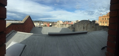 Victorian Interpretive Projects Inc.
Photograph - Colour, Clare Gervasoni, Ballarat towards Sturt Street from the Ballarat Trades Hall, 2015, 30/07/2015
Rooflines and buildings from the top of the Ballarat Trades Hall in Camp Street Ballarat.ballarat trades hall, camp street, sturt street, ballarat, aerial -
National Vietnam Veterans Museum (NVVM)
Film - Film, DVD, Wings over Vietnam: Volume 1, 1996
united states. air force -- history, vietnam war, 1961-1975 -- aerial operations, military operations, aerial -
National Vietnam Veterans Museum (NVVM)
Film - Film, DVD, Wings over Vietnam: Volume 3, 1996
united states. air force -- history, vietnam war, 1961-1975 -- aerial operations, military operations, aerial -
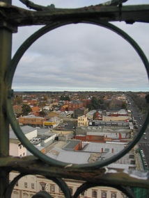 Ballarat Heritage Services
Photograph, L.J. Gervasoni, Ballarat from the Town Hall Tower, 2006, 14/06/2006
Ballarat looking toward St Patrick's Cathedral, from the Ballarat Town Hall tower. ballarat, aerial, ballarat town hall tower, st patrick's cathedral, sturt street -
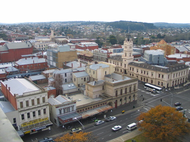 Ballarat Heritage Services
Photograph, L.J. Gervasoni, Ballarat from the Town Hall Tower, 2006, 14/06/2006
Ballarat looking toward the former Ballarat Post Office, from the Ballarat Town Hall tower. ballarat, aerial, ballarat town hall tower, sturt street, ballarat post office -
Glenelg Shire Council Cultural Collection
Photograph - Photograph - Aerial photograph of Portland harbour taken from the north east, 1967
Front: (no inscriptions) Back: Portland Harbour 1967/ No 6 berth under construction (ocean pier and railway pier still in existence)port of portland archives -
Glenelg Shire Council Cultural Collection
Photograph - Photograph - View of port, c. 1973
Port of Portland Authority archives.Front: (no inscriptions) Back: (no inscriptions)port of portland archives -
Glenelg Shire Council Cultural Collection
Photograph - Photograph - aerial view of Portland, c. 1954
Black and white aerial photograph of coastline around Portland. Black border, scale all sides, 5 rows of 3 't' at regular intervals. Ocean on left, land on rightFront: '607 - 54 ' - handwritten, white, border 'RUN 7' 'PORTLAND', printed, white, borderaerial photography, central portland, portland harbour, south west coastline -
Glenelg Shire Council Cultural Collection
Photograph - Photograph - aerial view of Portland, c. 1954
Black and white aerial photograph of coastline around Portland. Black border, scale all sides, 5 rows of 3 't' at regular intervals. Ocean at right, land on left.Front: '820 - 7' -- handwritten, white, lower border 'RUN 5' 'PORTLAND', printed, white, lower borderaerial photography, central portland, portland harbour, south west coastline -
Glenelg Shire Council Cultural Collection
Photograph - Photograph - aerial view of Portland, c. 1954
Black and white aerial photograph of coastline around Portland. Black border, scale all sides, 5 rows of 3 't' at regular intervals. 50/50 land and oceanFront: '607 - 51 ' - handwritten, white, border 'RUN 7' 'PORTLAND', printed, white, borderaerial photography, central portland, portland harbour, south west coastline -
Glenelg Shire Council Cultural Collection
Photograph - Photograph - aerial view of Portland, c. 1954
Black and white aerial photograph of coastline around Portland. Black border, scale all sides, 5 rows of 3 't' at regular intervals. 75/25 ocean to landFront: '784-146 ' - handwritten, white, border 'RUN - 7 A PORTLAND', printed, white, borderaerial photography, central portland, portland harbour, south west coastline -
Glenelg Shire Council Cultural Collection
Photograph, Arial view of CSR Softwoods, Dartmoor, n.d
Port of Portland Authority archives.Front: (no inscriptions) Back: (no inscriptions)port of portland -
 Glenelg Shire Council Cultural Collection
Photograph, CSR Softwoods/Dartmoor Mill, n.d
Port of Portland Authority archives.port of portland -
 Glenelg Shire Council Cultural Collection
Photograph, CSR Softwoods/Dartmoor Mill, n.d
Port of Portland Authority archives.port of portland -
 Glenelg Shire Council Cultural Collection
Photograph, CSR Softwoods/Dartmoor Mill, n.d
Port of Portland Authority archives.port of portland -
Glenelg Shire Council Cultural Collection
Photograph - Photograph - aerial view of Portland, c. 1954
Black and white aerial photograph of coastline around Portland. Black border, scale all sides, 5 rows of 3 't' at regular intervals. 60/40 land to ocean.Front: '607 - 93 ' - handwritten, white, border 'RUN - 6 PORTLAND', printed, white, borderport of portland archives, aerial photography, portland harbour, south west coastline