Showing 1338 items matching "department of state"
-
 Wodonga & District Historical Society Inc
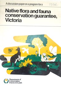
Book - Discussion Paper on Native flora and fauna conservation guarantee, Victoria, Department of Conservation, Forests and Lands, Victoria, 1986
This publication was produce as a discussion paper to inform decisions related to changes in land management and conservation regulations and policy in 1986An A4 size document outlining findings into an investigation into the state of flora and fauna in Victoria.This publication was produce as a discussion paper to inform decisions related to changes in land management and conservation regulations and policy in 1986land management, conservation victoria, water conservation -
 Wodonga & District Historical Society Inc
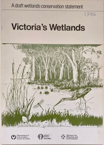
Book - Victoria's Wetlands, Dept. of Conservation, Forests & Lands, 1986
This publication was the result of an inquiry into the state of wetland environments in Victoria. It produced a draft strategy for conservation of threatened areas in the future.An 22 page book containing maps and illustrationsThis publication was the result of an inquiry into the state of wetland environments in Victoria. It produced a draft strategy for conservation of threatened areas in the future.wetland protection, wetlands victoria, water conservation -
 Wodonga & District Historical Society Inc
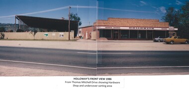
Photograph - Holloways Building Supplies
Eric Holloway began spot milling timber at age of 17. He borrowed fifty pound from an uncle in 1934 to purchase a McCormick Deering tractor and saw bench. He went from farm to farm cutting timber for farmers. For a time, he worked on Shelley Station spot milling with WS Walker and Son. In approximately 1946 Arthur and Eric Holloway established a saw mill at Shelley. Another brother Ernie, a builder and returned soldier, worked with them from time to time. Using timber sawn in the mill he built eight basic houses for the mill workers. The brothers employed many migrants: - Yugoslav, Czechs, Russians, Ukrainians, Serbs as well as other hardworking people. This meant there were families, so Ernie also built and furnished a school at Shelley. Application was made for a teacher from the Education Department. At the Shelley mill the workers used ex-army blitzes, GM trucks (for carting logs) army ducks and a centurion tank for parts. The timber from the mill was trucked to Albury and Wodonga, customers being FA Stowe and Mates Timber. The army was also a big customer with Holloways supplying timber for the army huts that were built at Bandiana. A timber mill that had been built at Tallangatta by State Rivers and Water for the purpose of establishing New Tallangatta, was purchased by Holloway Brothers as an extension of their Shelley operation. In 1954 a new mill was built at Granite Flat on the Omeo Highway and the Shelley operation closed. Ernie Holloway was involved in the building of the mill and accommodation houses in Mitta Mitta. The mill workers travelled from Mitta to work each day. Holloways Building Supplies was established at 49 Tallangatta Rd Wodonga at this time. It was established on four house blocks with a little shed, with more land being acquired as the operation expanded. The brothers realized that it would be more profitable to set up their own timber outlet to supply their customers. Arthur Holloway continued to run the sawmills while Eric Holloway concentrated on the Wodonga business. A hardware store, offices and joinery were built as demand continued for building materials. All the timber arriving in the yard from the mill was hand sorted, providing employment for many. With the milling and timber outlets Holloways provided employment for approximately forty staff. The next generation of the Holloway family became involved. A Hyster forklift was purchased which allowed for bulk handling of the timber. Land was purchased in Sanyo Drive where timber was cleated and dried. Select grade timber, F17 dry framing, builders hardware and tools were sold. Holloways endeavoured to be a one stop shop for framing and fitting out of houses. In 1989 the business was sold to Mt Beauty Timbers who later on sold to Dahlsens. The timber mill was decommissioned. The Holloway family retained the ownership of the premises of 49 Thomas Mitchell Drive leasing to Dahlsens until that operation was moved to Albury in 2013. In 2014 the lease land was sold to two local businesses. Leigh Martin Marine purchased the parcel of land adjoining their business. Lester and Son purchased the remaining block and demolished the premises. A funeral parlour was built on that site.These photos are significant because they document the story of an important Wodonga business.A series of coloured photographs depicting aspects of Holloways Building Supplies business in Wodonga.holloways wodonga, wodonga businesses, timber industry -
 City of Kingston
Photograph - Black and white, 5 January 1984
Moorabbin, Cheltenham and Highett are suburbs in the City of Kingston with a diverse mix of development and zoning. The market gardens, farms and paddocks have gradually been sub-divided into housing and industrial estates and associated infrastructure such as schools and shopping facilities. The area includes many parks, reserves and golf courses.This aerial image covers a diverse section of the City of Kingston, taking in the suburbs of Cheltenham, Moorabbin, Beaumaris and Highett. By 1984, the market gardens of the district have been replaced by housing and factories. The Gas and Fuel state-of-the-art Scientific Services Department is visible on Nepean Highway Highett. The CSIRO Highett site can also be seen. Both sites have now been demolished and have undergone remediation. The Southland site is visible and yet to be redeveloped by Westfield. This image portrays the diversity of development in the City of Kingston with a mixture of green spaces, housing and commercial and industrial features.Aerial photograph of Cheltenham, Beaumaris, Moorabbin and Highett within the City of Kingston. The area depicted in the 1984 aerial view includes Eden Street and Edward Street, Cheltenham (top left), Weatherall Road and Reserve Road, Cheltenham/Beaumaris (top right), Turner Road and Chesterville Road, Moorabbin (bottom left), Nepean Highway (left section), Graham Road and Middleton Street, Highett (bottom right). A large section of this image includes Cheltenham Park and Victoria Golf Club.White text: 3831-219 Lens information [indecipherable] RINGWOOD M/S 7922-3 RUN 15 Clockface image 5,300' ASL VIC DLS© 5-1-84cheltenham, highett, industrialisation, urbanisation, moorabbin, beaumaris -
 Melbourne Legacy
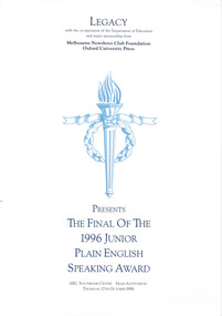
Programme, The Final of the 1996 Junior Plain English Speaking Award, 1996
From 1988 to 2021, Legacy held a public speaking contest for young secondary school students. It was initially called the Junior Plain English Speaking Award (JPESA) and later called Legacy Junior Public Speaking Award (LJPSA). Schools were eligible to send along up to 4 representatives to compete in a preliminary round. This State Final event was held on 17th October 1996, the National Final was on 11th November 1996. The event had co-operation from the Department of Education and the major sponsors were Melbourne Newsboys Club Foundation and Oxford University Press. The Victorian winner was Ross Ditcham, of Flinders Christian College, Hastings. Runner up was Luke Raffin from St Joseph's in Echuca. The following was taken this programme in 1996: "The Award aim is to promote enhanced oral communication skills for 12-14 year old students and to help young people appreciate the ideals of Legacy - voluntary service, caring and comradeship - and the need for remembrance. It began in 1988 in the Melbourne area with the support of the Ministry of Education and The Plain English Foundation. Entries have grown from 24 in the 1988 competition to over 300 in schools across the Stat, plus greater numbers participating in the process of selecting four contestants from each school. In 1995, a successful Interstate Championship was held with contestants from Victoria, New South Wales and Queensland." On 11 November 1996 the first National final was held with contestants from six states.A record of a Junior Plain Speaking contest that was run by Legacy from 1988 to the 1990s.Programme of Junior Plain Speaking contest in 1996legacy promotion, speaking contest, jpesa -
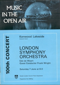 Federation University Historical Collection
Programme, Greater London Council Parks Department, Music in the open air, 1968-1970
Music in the Open Air was an initiative of Frank Wright, the Musical Director of the Greater London Council Parks Department. Frank Wright was a renown resident of Smeaton, where he was born in 1901. He lived at Laura Villa, and attended Smeaton State School. His father William was a gold miner and his mother's name was Sarah. He was the youngest of eleven children. Their family won many singing and instrumental awards. Frank was tutored by Percy Code and was awarded a gold medal for the highest marks in the ALCM examinations in the British Colonies at the age of seventeen years. He became the Australian Open Cornet Champion by the age of eighteen. A year later, Frank conducted the City of Ballarat Band, and later the Ballarat Soldiers’ Memorial Band. He formed the Frank Wright Frisco Band and Frank Wright and his Coliseum Orchestra. These bands won many South Street awards, and Frank as conductor won many awards in the Australian Band Championship contest. In 1933 Frank Wright sailed to England to conduct the famous St Hilda’s Band and was appointed in 1934 as the Musical Director of the London County Council (the GLC or Greater London Council), where he organized many amazing concerts in most of the 150 parks, in and around the London district. He was also responsible for some of London’s major concerts at Kenwood, the Crystal Palace and Holland Park. He was made Professor of Brass and Military Band Scoring and Conducting and was a Fellow of the Guildhall School of Music and Drama. Frank was often invited to adjudicate Brass Band Championships around Europe, in Australia, including South Street and in New Zealand. Frank was awarded an M.B.E. in 1967 and he died in November 1970. The Frank Wright Medal at the Royal South Street competition is awarded to an individual recognized as making an outstanding contribution to brass music in Australia.Two tone rectangular paper pamphlet of 4 double sided pages, with photo of an orchestra in a sound dome in top right hand corner. Held at Kenwood Lakeside for the Greater London Council Parks Department 11017.1 - Music in the open air: New Philharmonia Orchestra. Conducted by Norman del Mar, 11017.2 & .4 - London Symphony Orchestra. Conducted by Edo de Waart and Frank Wright 11017.3 - Royal Liverpool Philharmonic Orchestra. Conducted by Charles Groves. 11017.5 - Royal Liverpool Philharmonic Orchestra. Conducted by Charles Groves 11017.6 - Royal Philharmonic Orchestra - Conducted by Stanley Pope 11017.7 - New Philharmonic Orchestra - Conducted by Norman Del MarDesigned by GLC Supplies Department and printed by Staples Printers Limitedfrank wright, music in the open air, kenwood lakeside -
 Bendigo Historical Society Inc.
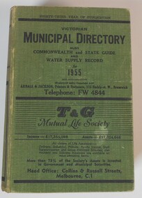
Book - BOOK: VICTORIAN MUNICIPAL DIRECTORY ALSO COMMONWEALTH AND STATE GUIDE AND WATER SUPPLY RECORD FOR 1955, 1955
BHS CollectionHard cover book with a woven green coloured cover, with black printing on front and spine. Contains 1071 pages of information concerning Federal, State and Local Government and their departments and Water Supply Authorities for 1955. Includes a section on City of Bendigo and surrounding local shires.Published by Arnall and Jacksongovernment -
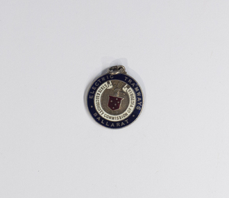
 Linton and District Historical Society Inc
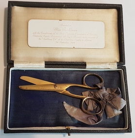
Box with scissors, Ceremonial Scissors, 1939, 1939
Box and scissors were afterwards presented to Ida Lewers, a daughter of Samuel Lewers, first Manager of the Bank of New South Wales in Linton.Small, oblong, black box, with opening stud at front. Box contains scissors used by Ida Lewers in ceremony to connect Linton to statewide electricity supply."Presented to-Miss I Lewers-with the Compliments of the State Electricity Commission of Victoria-Electricity Supply Department, Ballarat Branch, on the occasion of-the "Switching On" of the Electricity Supply to Linton-7th September 1939".ida lewers, events, electricity to linton 1939, grand switching-on carnival 1939 -
![Map, [Coornmill land area available for leasing for grazing, Parish of Coornmill]. Circa 1904](/media/collectors/5e461d8021ea67224c82f2a1/items/677cde147f2053f3e5d277c3/item-media/677cdeea7f2053f3e5d27bb4/item-fit-380x285.jpg) Bacchus Marsh & District Historical Society
Bacchus Marsh & District Historical SocietyMap, [Coornmill land area available for leasing for grazing, Parish of Coornmill]. Circa 1904
This map shows an area of land north of Bacchus Marsh in the Larderderg State Park area known as the Parish of Coornmill.The map indicates an area of land which was to be made available by public tender for grazing leaseholders. The plan to do this was discussed in the Bacchus Marsh Express newspaper on the 16 July, 1904, page 2, column 7. The area reserved for grazing leases is identified by red lines on the map. The Express described the area available for grazing was 12,000 acres.A single page paper map showing an area of land in the Parish of Corrnmill to be made available for grazing leases. A photo lithographed Lands Department Map. No scale indicated. The map is pasted into a bound volume containing 76 maps or plans in total. High resolution digital image stored on BMDHS computer network. coornmill parish maps, lerderderg state park maps, agriculture bacchus marsh area -
 Flagstaff Hill Maritime Museum and Village
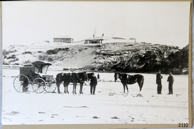
Photograph - Scene - Warrnambool, C. 1854-1871
This is an image of the Warrnambool Lighthouse Complex on Middle Island in 1854. The Store, Lighthouse Keeper's Quarters, Lighthouse and Flagstaff are in the background. The foreground shows a covered buggy drawn by two horses and a person in attendance, and another wheeled vehicle behind it with a figure nearby. There is a saddled horse to the right with two males in conversation nearby. The ground is soft, perhaps the riverbed or sandy shore. THE LIGHTHOUSE KEEPERS Lighthouse Keepers were responsible for keeping their Lighthouse’s lights shining at night. They kept a lookout for passing vessels and changes in weather. They were expected to clean, polish and maintain the equipment and buildings. They kept regular and detailed records of who was on watch, and the time the light was lit, trimmed and extinguished. They kept a journal about other events that occurred. They keep regular, accurate Meteorological Logs. It was expected that they were competent in Morse code signalling. They would be called to help in times of disasters and shipwrecks and to give official statements about these events. Many Lighthouse Keepers also volunteered as members of the lifeboat crew. The Lady Bay lighthouses were officially classified as small, so the Keepers had the official titles of Senior Assistant Lighthouse Keeper and Assistant Lighthouse Keeper. They were employed by the Public Service and paid rent to live in the Lighthouse Quarters. They were compulsorily retired at the age of 60, with most receiving a superannuation payment. Despite their time-consuming duties, there was time to follow hobbies and crafts such as growing vegetables, playing musical instruments, making models of buildings including lighthouses, and crafting furniture pieces. An example of a keeper’s skills is the carved fire screen made by /assistant Keeper Thomas Hope in the late 19th century and displayed in the Lighthouse Keeper’s cottage at Flagstaff Hill. Both Alexander and Farncombe had served under Senior Keeper Robert Deverell, who was the first and only Senior Lighthouse Keeper at the Middle Island Complex. John Alexander was the Assistant Keeper in the 1850s. Andrew Farncombe was the last Assistant Keeper at Middle Island, serving there with his family from 1864 to 1871. During 1871 and 1872 the Lighthouse Complex was moved to Flagstaff Hill on Merri Street. Farncombe and Deverell then became the first Keepers and occupants of the Lady Bay Lighthouse Complex at Flagstaff Hill. They continued their service together; overall, Deverell served from 1859 to 1885 and Farncombe from 1864 to 1974. WARRNAMBOOL'S LADY BAY LIGHTHOUSE COMPLEX - The original Lighthouse Complex was built on Middle Island in 1858-1859 then transferred stone-by-stone to Flagstaff Hill in 1871. The Complex comprised the Lighthouse, the Lighthouse Keepers’ Quarters and a Privy. The bluestone Keeper’s Quarters was a cottage divided into two compartments, one for the Senior Keeper and his family, the other for the Assistant Keeper and his family. The bluestone Store was divided into three; a store, a workshop, and an oil store (or office). The Privy comprised a small building also divided into two separate, back-to-back toilets, one for each Keeper and his family. In the 1970s the Flagstaff Hill Planning Board was set up under the chairmanship of John Lindsay. The Board was to make recommendations to the Warrnambool City Council regarding the use of the buildings and the rest of the Crown Land on the site. The Flagstaff Hill Maritime Village opened in 1975 and began renovating the Cottage in stages, during which time evidence of a 1920s fire was found in the eastern section of the cottage. Additions of a porch on the west and a washroom on the east were made in the 1980s. The western part of the building is now a Shipwreck Museum and the east has returned to a late 19th-century Lighthouse Keeper’s cottage and includes the screen made by Assistant Lighthouse Keeper Thomas Hope in the late 19th century. Hope served two periods of time at the Lighthouse. This photograph is significant as a visual record of the original Warrnambool Lighthouse Complex on Middle Island, the origin of what is now the Lady Bay Lighthouse Complex. The photograph is significant for its connection to the Complex, which is now listed on the Victorian Heritage Register, H1520, for being of historical, scientific (technological) and architectural significance to the State of Victoria. The Complex is significant as an example of early colonial development. The photograph is significant for its connection with the important navigational function of the Lighthouses, a function still being performed to this day. The photograph is also significant as it shows an example of buildings organised by the Public Works Department in Victoria in the mid-to-late 19th century. The structures tare still stand strong. Photograph of horses, a buggy and three gentlemen in the foreground and the background shows a lighthouse and accompanying buildings. Printed in black and white. (Another two horse-drawn vehicles are partially visible). The subject is the Lighthouse Complex on Middle Island, Warrnambool, dated between 1854 and 1871.An inscription is handwritten in black pen on the back of the mounting board."The lighthouse and accompanying buildings were / established on Middle Island in 1854, as this / picture shows. In 1871 they were moved to their / present site on Flagstaff Hill."flagstaff hill, flagstaff hill maritime museum, flagstaff hill maritime village, warrnambool, maritime museum, shipwreck coast, lighthouse keeper's cottage, lighthouse residence, lighthouse, chart room, quarters, privy, middle island, beach lighthouse, obelisk, lighthouse complex, lady bay complex, warrnambool port, warrnambool harbour, lady bay, keepers, lighthouse keeper, upper lighthouse, lower lighthouse, assistant keeper, ports and harbours, cottage, meteorological record, 1854, 1871 -
 Bacchus Marsh & District Historical Society
Map, Village allotments, Parish of Myrniong, County of Bourke
Myrniong is a village 9 kilometers west of Bacchus Marsh. Prior to 1863 the area was known as Blow's Flat. This map which was produced in 1903 and according to the catalogue record of this map held at the State Library of Victoria was based on an earlier map created in 1861. The early layout of streets for the village of Myrniong can be seen on this map. The streets shown are, Main Street, Hardy Street, Blow Street, Myrniong Street, Shuter Street, and Blackwood Street. An area marked as a reserve for a school can be seen between Hardy Street and Main Street.A single page paper map. A cadastral parish map of Myrniong in Victoria, showing numbered land allotments. Photo-lithographed at the Department of Lands & Survey, Melbourne, in 1903. Based on an original map created in 1861. The map is pasted into a bound volume containing 76 maps or plans in total. High resolution digital image stored on BMDHS computer network. Surveyed by John Hardy, Surveyor ; photo-lithographed at the Department of Lands & Survey, Melbourne by T.F. McGauran, 24.12.03myrniong parish plan, myrniong parish maps -
 Department of Energy, Environment and Climate Action
Display board
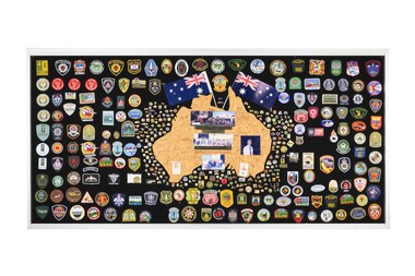
The Forests Commission and its successors continuously encouraged bushfire research and innovation. In 1946 a large parcel of industrial land was purchased at North Altona as a fire cache and workshop. The Altona workshop became a hotbed of new technological innovation… an exhilarating place where lots of things were invented and tested. In fact, a lot of Australia’s pioneering equipment development was led by staff from Altona, often in collaboration with other State forestry and fire authorities. The CSIRO also contributed significantly. The US Forest Service, the US Bureau of Land Management and US State agencies such as the California Department of Forestry and Fire (CalFire) as well as the Canadian Forest Service faced similar challenges and proved strong and willing partners in sharing knowledge, ideas, equipment and expertise over many decades. This collection of badges is testament to the relationships that were forged across the globe with the Altona workshop. Large display panel featuring many fire service badgesforests commission victoria (fcv), bushfire, bushfire aviation -
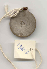 Ballarat Tramway Museum
Badge - SEC pass - set of 27, AMOR, c1950?
Set of 27 Stamped enamelled round brass pieces with a hole stamped at the top and ring placed through. Used as a SEC tramways employees pass for either all Provincial tramways, Ballarat or Bendigo only. All badges have the SEC logo in the centre, organisational name (State Electricity Commission of Victoria) in white enamel and outer ring the words "Electricity Supply Department, Provincial Tramways", or "Electric Tramways Ballarat" or "Electric Tramways Bendigo". This is in blue enamel. On the rear are stamped numbers and manufacturers name - "AMOR" or "AMOR MELB" or "STOKES & SONS MELBOURNE" in the bottom portion of the pass. Items .1 -> .10, .12, .13 individually tagged. Item .11 not tagged Item .13 -> .27, single tagged, tied together with a length of string. 1941.1 - Bendigo - No. 9 - Stokes - silver background instead of gold, appears to have been used. .2 - Bendigo - No. 43 - Stokes - has been used - partially worn, has additional clip joined to main ring. .3 - Ballarat - No. 51 - Stokes - has been used, worn and chipped under main ring. .4 - Ballarat - No. 61 - Stokes - has been used, worn, and chipped on blue enamel in at least two places. .5 - Ballarat - No. 72 - Stokes - has been used, worn and chipped on blue enamel in many places - btm1941i1 for reverse side. .6 - Ballarat - No. 86 - Stokes - has been used, worn, dirt on rear - see image btm1941i2 for front side. .7 - Bendigo - No. 107 - Stokes - appears not to have been used - see image btm1941i3 for front side .8 - Bendigo - No. 108 - Stokes - ditto, but gold by SEC shield is discoloured - see image btm1941i4. .9 - Bendigo - No. 121 - Stokes - appears to have been used, more silver than 1941.8 .10 - Provincial - No. 124 - AMOR - may have been used - see image 1941i5 for front side .11 - Provincial - No. 156 - AMOR - small clip broken off at top, has been used, worn (Not tagged) .12 - Provincial - No. 306 - AMOR - no larger ring, has been used, worn and discoloured .13 - Provincial - No. 656 - AMOR MELB - has not been used, no larger ring, see image 1941i6 for back side. .14 - Provincial - No. 642 - AMOR MELB - has not been used. .15 - Provincial - No. 644 - ditto .16 - Provincial - No. 645 - ditto .17 - Provincial - No. 646 - ditto .18 - Provincial - No. 647 - ditto .19 - Provincial - No. 648 - ditto .20 - Provincial - No. 649 - ditto .21 - Provincial - No. 650 - ditto .22 - Provincial - No. 651 - ditto .23 - Provincial - No. 652 - ditto .24 - Provincial - No. 653 - ditto .25 - Provincial - No. 654 - ditto - to A. Reither for 21st from BTM 2/8/03 - see attached image btm1941i7 .26 - Provincial - No. 655 - ditto - to P.Mong for 21st from BTM 2/8/03 - see ditto .27 - Provincial - No. 564 - ditto - added 21/1/2007 from somewhere - at WAD's house 12/2006. .28 - Provincial - No. 589 - ditto - dittotramways, trams, employees pass, tickets, provincial tramways, badges -
 Ballarat Tramway Museum
Badge - SEC pass - set of 12, AMOR, c1940?
Set of 12 Stamped enamelled round brass pieces with a hole stamped at the top and ring placed through. Used as a SEC tramways employees pass for either all Provincial tramways, Geelong, Ballarat or Bendigo only. All badges have the SEC logo in the centre, organisational name (State Electricity Commission of Victoria) in white enamel and outer ring the words "Electricity Supply Department, Provincial Tramways", or "Electric Tramways Ballarat" or "Electric Tramways Bendigo" or "Electric Tramways Geelong". This is in blue enamel. On the rear are stamped numbers and manufacturers name - "AMOR MELB" or "STOKES & SONS MELBOURNE" in the bottom portion of the pass, except .9 which is "STOKES" only. Items .1 -> .12 individually tagged. 1941.1 - Geelong - No. 46 - Stokes - silver background, has been used - see image file btm1942i1 and for back btm1942i2. .2 - Bendigo - No. 51 - Stokes - has been used - partially worn, silver background. .3 - Ballarat - No. 49 - Stokes - may have been used, silver background, silver background. .4 - Ballarat - No. 100 - Stokes - has been used, red in shield very faded, silver background. .5 - Ballarat - No. 102 - Stokes - has been used, worn and chipped on blue enamel near top gold centre, brass back. .6 - Bendigo - No. 105 - Stokes - gold/brass back, may have been used, some wear on right side. .7 - Ballarat - No. 106 - Stokes - appears to have been used - dirt marks on rear and front of badge, brass/gold background. .8 - Bendigo - No. 106 - Stokes - appears not to have been used, brass/gold quite bright. .9 - Geelong - No. 111 - Stokes - appears to have been used, silver back - see image file btm1942i3. .10 - Bendigo - No. 123 - Stokes - may have been used - silver background. .11 - Provincial - No. 570 - AMOR MELB - has not been used brass/gold background. .12 - Provincial - No. 657 - AMOR MELB- has not been used, brass gold background.tramways, trams, employees pass, tickets, provincial tramways, badges -
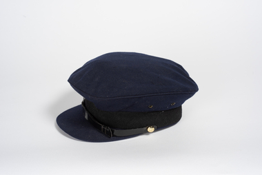 City of Greater Bendigo - Civic Collection
Uniform - Department of Supply Cap, 1971
... of the Special Minister of State. The Department was a Commonwealth... of the Special Minister of State. The Department was a Commonwealth ...Established in 1950, the Department of Supply headquarters transferred to Canberra in January 1968 and was dissolved in 1974. It was superseded by the Department of Manufacturing Industry and Department of the Special Minister of State. The Department was a Commonwealth Public Service department, staffed by officials who were responsible to the Minister for Supply. The department's main function was to support Australia's Navy, Army and Air Force in defence production, research and development, purchasing, transport and storage. The Department was also the Commonwealth Disposals Authority. Finally, the Department was responsible for the Australian Antarctic program. Bendigo was the site of an Ordnance Factory and manufactured and reconditioned naval guns and mountings, turbine gears for large ships, general heavy engineering work, large fabricated structure and missile handling equipment. The factory was managed in 1970 by R.I.M Moss. The department may have had an office in the former Bendigo Post Office now the Bendigo Visitor Information Centre.Blue, felt or wool peaked service cap with woven band and plastic strap. Small brass buttons. The cap has a synthetic lining around the crown and on the roof of the cap. Marked on the inside with the maker's details.bendigo post office, city of greater bendigo uniform -
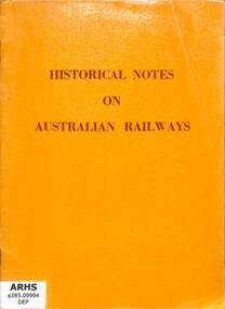 Victorian Railway History Library
Book, The Department of Railways, Historical Notes on Australian Railways
Historical notes on the origins of the different State Railways in Australia from 1840sp.20.non-fictionHistorical notes on the origins of the different State Railways in Australia from 1840srailroads -- australia -- history., railway construction - australia -
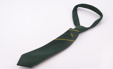 Forests Commission Retired Personnel Association (FCRPA)
Uniform - Forests Commission Victoria (FCV) tie and epaulets (to be worn on polyester shirt) as dress uniform, pre 1984
Polyester shirts plus a green tie and epaulets were the only form of dress unform issued to FCV staff. In later years a brown tie was available. Blue work overalls and safety boots were issued for bushfire work. These were replaced with the now familiar bright green overalls in about 1984. There were no dress pants, jumpers, jackets or shoes issued. This led to a long running dispute between the staff association and the Commission over departmental uniform policy at the time. David Parnaby was a District Forester and accomplished cartoonist who provided insightful and humorous commentary on uniforms through the Victorian State Forester’s Association Newsletter.Example of early staff uniform.Green polyester tie with yellow stripe and round FCV logo. Green FCV epaulet to be worn on polyester shirt as dress uniform. uniforms, forests commission victoria (fcv) -
 Eltham District Historical Society Inc
Document - Map, Victoria. Department of Crown Lands and Survey, Town of Eltham, Parish of Nillumbik, County of Evelyn, 2 October 1929
Township of Eltham, Parish of Nillumbik, County of Evelyn / lithographed at the Department of Lands & Survey Melbourne 5th June 1888, amended 2 October 1929 This amendment from the 1888 original shows the reserve for the the State School marked as permanent with dimensions added to Main Road and block frontages along Main Road between Mount Pleasant Road and Dalton Street and Metery Road Possibly photocopied from a copy held at PROV by Harry Gilham whilst resaerching Eltham Primary School history in 1995.a. armstrong, a. lavard, arthur c. allan, arthur c. allen, b. bowatere, baxter street, benjamin oliver wallis, bolton steet, c. souter, c.s. hain, cemetery reserve, charles brown, charles newman, charles symons wingrove, christopher caldwell, church of england, d. anderson, dalton street, david ballard, e. james, e.m. peck, edward dumaresq, eltham town, ely street, f.e. falkiner, f.m. peck, falkiner street, flint street, g. buckingham, g. drabble, george stebbing, godalmin street, h. peck, h.c.whess, h.h. farquharson, h.j. bews, henry stooke, j. goer, j. mcdonald, j. mclaren, j. roberts, j.b. knagers, james irish, jane bailey (nee matthews), john l. smith, john mason, john scott, john smith, joseph stevenson, joseph verse, k. wingrove, k.e. dunstan, kerby street, kirby street, location tbd, m. coman, map, michael o'shea, o.b. mccutcheon, p. & g. tumbull, p.k. mccaughan, p.p. cotter, porter street, pound reserve, robert hepburn, roman catholic church, s. evans, samuel dagley, samuel phillips, samuel ramsden, t. upton, t. watkins, t.a. stark, t.c.b. batt, t.p. cross, thomas grant, thornton street, w. adam, w. blain, w. long, w. watkins, w.f. ford, w.h. hull, w.r. belcher, w.t. schultz, william thomas, eltham primary school, eltham state school, eltham state school no. 209, quarry reserve -
 Eltham District Historical Society Inc
Film - Video (VHS), Jenni Mitchell, Demolition of the Shire of Eltham Offices, 1996
Poor video quality (noise and interference), incomplete and unedited raw footage. A video documenting the demolition of the Shire of Eltham offices at 895 Main Road Eltham under the direction of the Commissioners appointed for the new Shire of Nillumbik and some of the communities activities surrounding the event. The building was demolished exactly 25 years after the southern wing housing Engineering and Planning on the upper level and the Eltham Library on the ground level was opened in celebration of the Shire of Eltham's centenary. Video has lots of distortion and noise, and sections of clips dubbed over. Immediate initial footage of Jenni Mitchell talking about asbestos claims in the Shire Offices (Sigmund Jorgensen standing behind her) advising Council did a review of the building several years previously and had been cleared of health problems. Cuts to group of people standing outside front door of offices but possibly voice dub over not related ? Then the date 27 Jul 1996 on a scene flashes on screen immediately followed by an edited clip intro of title and credits with classical music track. It then opens with Jenni Mitchell driving to the Shire Offices on Saturday 27 July 1996 at 11.00am. Footage of Main Road past Pitt Street, Alistair Knox Park then entering Shire Office driveway which is fenced off and contractor signs hanging up. Scenes at rear of building showing some internal demolition has commenced. View of the Administration wing. More clips of road driving, Alistair Knox Park, Eltham Library and visitor car park for Shire Offices. Cuts to a group of people standing in access to visitor carpark with new Eltham Library in background, one being immediate former Shire of Eltham President, John Graves. Scenes of people looking through chain link fence and security guard checking front door. John Graves being filmed that someone informed him the Shire was offering the building to the Community Health Centre for $2.3 million and that if they had been offered a price of $1.1 for what it apparently was sold for they would have snapped it up. View of truck loaded with brick rubble literally struggling to ascend the hill of Library Place to exit into Main Road. Cuts to a scene looking at Eltham War memorial Hall through the Memorial Gate, then the Shillinglaw trees and large banner sign ‘Delta Demolitions’ hanging on office façade. Views of front door, old library and bluestone wall. Scene (31 Jul 1996) filmed at night of several white crosses with “RIP Community” and “RIP Democracy”. Scene (1 August 1996) again driving along Main Road towards the Shire Offices then scenes of the offices showing substantially more demolition to exterior, groups of people standing on footpath outside watching, Delta heavy demolition machines, woman holding sign “Democracy where have you gone …”, the odd person in full protection gear and breathing apparatus hand carrying materials out to place on rubbish pile in front of people standing on footpath watching (with no protection) and then stamping on it to break it creating dust, security person in hard hat (no other protection) wandering around, many groups standing around watching, news film crew, person standing on roadside edge holding signs facing traffic stating “Pirate Planning” and “ Grant us your ears” also sign on back of parked car “Elthams High Jacks”, another sign “Community Democracy”, views of crosses in Main Road median strip “RIP Community”, groups of people on footpaths and reporters conducting interviews, footage of unknown person standing with Jenni Mitchell and Sigmund Jorgensen advising people have the right to protest, Jenni Mitchell urging people to ask questions of local MP and Council and Sigmund Jorgensen referring to the three historic Shillinglaw trees with demolition machinery operating in background, Jenni Mitchell and others installing more crosses in median strip; demolition machines operating inside and outside the building, more views of onlookers including Sigmund Jorgensen then Police approaching on footpath, workers and machinery continuing to operate, views of the old library being demolished, the former Community Services department, security personnel. Scene (2 August 1996) more heavy demolition machinery in operation smashing building up, people standing around southern wing watching, view overlooking Eltham Library of train pulling in to Eltham station. Scene (7 August 1996) more heavy demolition and people wandering around with only hard hat protection, no dust protection, comments from one operator dumping a bin of material stating “wait till there’s a Hungry Jack’s here, you’ll be laughing, fuel, videos, hamburgers. You’ll be up with the rest of the world soon, you’ll have electricity and everything here, ha ha ha ha”, more heavy machinery demolition and breaking up of materials, view of Hitachi train going by and Administration wing, view inside the front door opening of the staircase leading to upper level, person walking around operating heavy machinery with a hose spraying rubble (no protective gear other than hard hat interspersed with edit cuts of meeting of Commissioners and independent observers on panel as well as members of the community in public gallery. Nillumbik Shire CEO Barry Rochford addressing the meeting., Chief Commissioner Don Cordell directly addressing Jenni Mitchell with respect to permission to take photographs, Barry Rochford continues to address the question asked of Council about the valuation of the former Shire of Eltham Office building/site, public gallery calling out asking why was building demolished, what was the urgency. Scene (14 August 1996) views of southern wing, previous single demolition operator again mocking people filming, operators working in and around building, Shillinglaw trees and largely demolished front, heavy demolition equipment at work, piles of building rubble, hose spraying water over rubble, large trucks arriving for rubble removal and loading of truck. Scene (21 August) more of the same, building virtually down, Shillinglaw trees standing tall and alone, water spraying on rubble and wattle in bloom. Cuts to Council meeting with public onlookers. Barry Rochford walks out, Wayne Phillips addresses meeting explaining one or two people shouting, members of the community challenging Council (Commissioners) about why due process appear to have been subverted. Former Shire President Robert Marshall in public audience, cuts back to Shire office carpark entrance site and sign hung on fence in front of library “Think Again!” and people standing around observing awaiting a protest demonstration erecting a large sign on stilts stating “Shell No!”, people singing a revised version of God Save the Queen (God Save Us All), Sigmund Jorgensen in attendance, Jenni Mitchell, Sigmund Jorgenson and others address the protest crowd, followed by people mingling, music being played then people standing around the cleared site circumference all with arms linked (video very broken up with noise) then chants “Save the Gateway” and “No Shell for Eltham” and more music and singing “Put up a parking lot”. The crowd then proceeds to walk along the footpath of Main Road. Scene (15 Sep 1996) meeting at Montsalvat in Great Hall addressed by Sigmund Jorgensen discussing a recently published list of the Commissioner’s to senior Council Officers of banned Nillumbik people, others encouraging people to view proposed plans for the site and lodge objections. Specific issues regarding asbestos claims are also addressed. Harry Gilham addresses the meeting on the subject of the Eltham War Memorial and Memorial Gardens and how Council believe a roundabout in the vicinity is of greater importance. Views of various artworks on display (for auction) and music performance in the Barn Gallery. Meeting addressed by Sigmund Jorgensen discussing an appeal against Council granting a permit to Dallas Howgate to develop the site and that the Minister has called the matter in to be decided by the governing council. This is followed by an auction of paintings. 0.05 - Jenni Mitchel, Sigmund Jorgensen and Peter Doughtery in background. 0.18 - Jock Kyme in front of building – David Essex, Marg Johnson on his left-hand side. 5.34 - John Graves – ex Shire of Eltham Councillor and President. 9.02 - Unknown person being interviewed. 9.30 - Jenni Mitchell, unknown person, Mark Burns, community activist. 10.04 - Sigmund Jorgenson, Jenni Mitchell. 12.04 - Police members 21.33 - Nillumbik Council offices 7 August 1996 Barry Rochford CEO, Vin Heffernan Commissioner, Don Cordell Chief Commissioner, Kevin Abbott Commissioner, unknown person. 28.00 - Barry Rochford CEO 28.05 - Kahn Frankie - in commissioner’s seat after commissioners and council staff have vacated the council chamber. 28.26 - Wayne Phillips, State Liberal member for Eltham, addressing community in response to questions. 28.36 - Mark Burns, community activist addressing gallery. 28.48 - Ken Hines, ex Shire of Eltham Councillor and President. 29.34 - Ken Hines, ex Shire of Eltham Councillor and President standing, Robert Marshall, ex Shire of Eltham Councillor and President seated in front. 29.41 - Karen Gerhards, community activist. 30.06 - Marg Johnson with loud hailer, next to Jock Kyme, community activist. 31.32 - Marg Johnson with possibly Frank Burgoyne?, Sigmund Jorgensen, Jock Kyme. 35.35 - Harry Gilham at meeting at Montsalvat on 15 September 1996. 35.43 - Sigmund Jorgenson at lectern. 36.42 - Marg Jennings. 37.47 - Mark McDonald, Jim Connor, ex Shire of Eltham Councillor in background. 36.28 - John Cohen, ex Shire of Eltham Councillor and President. 38.56 - Ken Hines, ex Shire of Eltham Councillor and President. 41.11 - Harry Gilham, president of the Eltham District Historical Society. 43.55 - Sigmund Jorgensen in Long Gallery at Montsalvat, at start of the art auction to raise funds for community action. 45.50 - Unknown person conducting art auction. VHS Video cassette (poor quality) Converted to MP4 file format 45:01, 535MBvideo recording, 895 main road, alistair knox park, artworks, auction, barn gallery, barry rochford, community health centre, dallas howgate, delta demolitions, demolition, don cordell, eltham, eltham library, eltham shire office, eltham war memorial, eltham war memorial gate, eltham war memorial hall, great hall, harry gilham, jenni mitchell, john graves, library place, main road, memorial gardens, mervyn hannan, montsalvat, pitt street, protest, robert marshall, roundabout, shell oil, shillinglaw trees, sigmund jorgensen, sign, wayne phillips -
 Warrnambool and District Historical Society Inc.
Booklet, New Bennettitalean Leaves from the Mesozoic of Eastern Australia, 1963
This booklet contains an article on the plant fossil deposits in Eastern Victoria. It has been written by Dr John Douglas in 1963. He published extensively on a range of geological and natural history themes. His major works included co-editing the Geological Society of Victoria’s Geology of Victoria and his PH.D. thesis for the University of Melbourne contained in two Geological Survey Memoirs on the Mesozoic floras of Victoria. He was also responsible for the Geology and Sport and Recreation chapters in the State Government’s Atlas of Victoria and wrote the booklet, What Fossil Plant is That? He was a Supervising Geologist with the Department of Minerals and Energy in Victoria for many years and lectured extensively at Botany and Geology conferences in Australia and overseas. This book is of some interest as it was written by a former resident of Warrnambool, Dr John Douglas (1997 to his death in 2007). He was an active member of the Warrnambool Field Naturalists’ Group and edited for this group the book, The Nature of Warrnambool. This is a small booklet of 16 pages reprinted from the Proceedings of the Royal Society of Victoria, Vol. 77, Part 1. It has a grey cover with the logo of the Royal Society of Victoria on the front cover. It has printed material on plant fossil deposits in eastern Victoria and several sketches and black and white plates of plant fossil photographs and cross-sections. The pages were stapled but the staples have been removed. There is some rust where the staples were removed. Front cover: ‘Royal Society of Victoria, New Bennettitalean Leaves from the Mesozoic of Eastern Australia by J. G. Douglas, reprinted from Proc. Roy. Soc. Victoria, Vol 77, Part 1, Issued separately, 13 December, 1963.’ micro- paleontology in eastern victoria, dr john douglas, warrnambool -
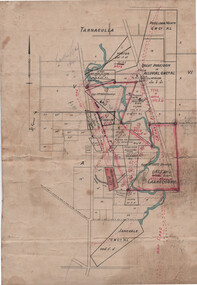 Tarnagulla History Archive
Linen-Backed Map of Poseidon Goldfield, c1915, with Mining Leases and Shaft locations
This is a very nice foolscap-size map, probably prepared by a Mines Department or other Government surveyor with the intention of assisting to attract mining capital to the goldfield. The red sketched-in deep lead positions are inaccurate. The pencil notation upper left reads "Lowther's Lease 6415". Lowther was a Tarnagulla mining promoter of the time. The Tarnagulla Racecourse location is marked as is the Woolshed Reef State School. -
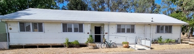 Wodonga & District Historical Society Inc
Photograph - Hut 97 Bonegilla Migrant Experience
Bonegilla Army Base and Migrant Reception Centre began when funds were allocated to build Bonegilla Army Camp in June 1940. Builders began to erect about 600 huts prior to the Army moving in during September of that year. Between 1942 - 1943 it was enlarged to 848 buildings. In 1947 Bonegilla Reception and Training Centre began operating with the Army providing transport, security and catering services. From 1949 until 1965 the Bonegilla Reception and Training Centre operated without a military presence. Bonegilla Migrant Reception and Training Centre was made up of 24 blocks. It had its own churches, banks, sporting fields, cinema, hospital, police station and railway platform. It became the largest and longest operating reception centre in the post-war era. More than 300,000 migrants passed through its doors between 1947 and 1971, with most of those originating from non-English speaking European countries. From1965 with the increased Australian commitment to the Vietnam War and the need to find accommodation to train National Servicemen for Vietnam, the Army negotiated with the Department of Immigration to take over several blocks at Bonegilla. In 1971 the Reception Centre closed and the site reverted to the Army. After 1971 the Army undertook a major site redevelopment with the construction of Latchford Barracks as the Army Apprentice School. Later Latchford Barracks was redeveloped into part of the Army Logistic Training Centre. Between 1978 and 1982, nearly all of the centre was demolished in a major redevelopment. The new replacement buildings were formally opened as Latchford Barracks in 1983. Demolition of the buildings prompted calls for recognition of the site and the role it had played in Australia’s post-World War II Immigration program. After much discussion between the Department of Army and Heritage and local groups about the significance of the site, the Australian Heritage Commission proceeded with its listing on the Register of the National Estate. A Conservation Management Plan was prepared for Block 19 in 1996. The Army transferred Block 19 to the Victorian Government. In 2002 Heritage Victoria listed Block 19 on the State Heritage Register, giving attention to both the migrant and army connections with the site. Hut 97 at Bonegilla Migrant Experience is the home of the Wodonga & District Historical Society Inc.This image is significant because it records a building which is part of the Bonegilla Migrant Reception Centre which played a critical role as the largest and longest operating Migrant Reception Centre in Australia.A colour photo of Hut 97 at Block 19, Bonegilla Migrant Experience, now the home of Wodonga & District Historical Society Inc.hut 97 bonegilla migrant experience, wodonga & district historical society, immigration australia -
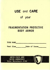 National Vietnam Veterans Museum (NVVM)
Manual, U.S. Department of the Army, Use and Care of your Fragmentation Protective Body Armor
A yellow coloued cardboard cover with black information on the front. Top of the cover reads Use and Care. Bottom of the cover over black ink reads United State Army etc. The booklet is held together with two metal staples down the spine of the booklet.military uniforms, fragmentation protective body armor -
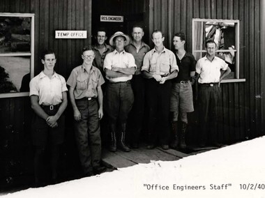
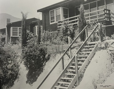 Falls Creek Historical Society
Photograph - Bogong Alpine Village Houses 1946
The images in the Bogong Village Collection were displayed in Bogong Jack’s Tavern for over 20 years and were donated to the Falls Creek Museum when the Tavern closed in 2021. In 1939, the State Electricity Commission of Victoria established a field headquarters at Bogong to house workers and their families for the Kiewa Hydroelectric Scheme which ran from the 1930s to the 1960s. The workmen's camp was originally started with tents and was called Junction Camp. By 1947, the village supported 300 workers and their families. It included 40 houses, a hostel for single staff, a post office, a police station, a medical centre, and a primary school. The staff hostel was known as Kiewa House. At the completion of the Scheme, in the 1960s, the village was opened to public/tourism use. In 1968 the Victorian Education Department acquired the camp buildings and four houses from the State Electricity Commission of Victoria to establish an Outdoor Education Centre which operated for over 50 years. The Kiewa Hydroelectric Scheme was privatized in the 1990s and sold to Southern Hydro, before being acquired by AGL in 2005. In 2023 the Grollo Group signed a 73 year sublease on Bogong Village and has plans for its redevelopment as a workers’ village.These images are significant because they capture the development of Bogong Village as an important element of the Kiewa Hydroelectric Scheme in Victoria.Two black and white images featuring houses in Bogong Village in January 1946. They are constructed of weatherboard, with brick chimneys and tin roofs. Timber steps lead up to the front door and a garden has been planted in front of the house.bogong alpine village, bogong high plains, bogong houses 1946 -
 Falls Creek Historical Society
Photograph - Bogong Alpine Village 1944
The images in the Bogong Village Collection were displayed in Bogong Jack’s Tavern for over 20 years and were donated to the Falls Creek Museum when the Tavern closed in 2021. In 1939, the State Electricity Commission of Victoria established a field headquarters at Bogong to house workers and their families for the Kiewa Hydroelectric Scheme which ran from the 1930s to the 1960s. The workmen's camp was originally started with tents and was called Junction Camp. By 1947, the village supported 300 workers and their families. It included 40 houses, a hostel for single staff, a post office, a police station, a medical centre, and a primary school. The staff hostel was known as Kiewa House. At the completion of the Scheme, in the 1960s, the village was opened to public/tourism use. In 1968 the Victorian Education Department acquired the camp buildings and four houses from the State Electricity Commission of Victoria to establish an Outdoor Education Centre which operated for over 50 years. The Kiewa Hydroelectric Scheme was privatized in the 1990s and sold to Southern Hydro, before being acquired by AGL in 2005. In 2023 the Grollo Group signed a 73 year sublease on Bogong Village and has plans for its redevelopment as a workers’ village.These images are significant because they capture the development of Bogong Village as an important element of the Kiewa Hydroelectric Scheme in Victoria.A collection of four black and white images capturing the weather conditions in the Bogong area in June 1944bogong alpine village, bogong high plains, bogong june 1944 -
 Falls Creek Historical Society
Photograph - Bogong Alpine Village 1947
The images in the Bogong Village Collection were displayed in Bogong Jack’s Tavern for over 20 years and were donated to the Falls Creek Museum when the Tavern closed in 2021. In 1939, the State Electricity Commission of Victoria established a field headquarters at Bogong to house workers and their families for the Kiewa Hydroelectric Scheme which ran from the 1930s to the 1960s. The workmen's camp was originally started with tents and was called Junction Camp. By 1947, the village supported 300 workers and their families. It included 40 houses, a hostel for single staff, a post office, a police station, a medical centre, and a primary school. The staff hostel was known as Kiewa House. At the completion of the Scheme, in the 1960s, the village was opened to public/tourism use. In 1968 the Victorian Education Department acquired the camp buildings and four houses from the State Electricity Commission of Victoria to establish an Outdoor Education Centre which operated for over 50 years. The Kiewa Hydroelectric Scheme was privatized in the 1990s and sold to Southern Hydro, before being acquired by AGL in 2005. In 2023 the Grollo Group signed a 73 year sublease on Bogong Village and has plans for its redevelopment as a workers’ village.These images are significant because they capture the development of Bogong Village as an important element of the Kiewa Hydroelectric Scheme in Victoria.Two black and white images capturing Bogong Village by night and the spillway at Junction Dam.bogong alpine village, bogong high plains, bogong 1947 -
 Falls Creek Historical Society
Photograph - Jack Maddison Leading horses on the Bogong High Plain
The images in the Bogong Village Collection were displayed in Bogong Jack’s Tavern for over 20 years and were donated to the Falls Creek Museum when the Tavern closed in 2021. In 1939, the State Electricity Commission of Victoria established a field headquarters at Bogong to house workers and their families for the Kiewa Hydroelectric Scheme which ran from the 1930s to the 1960s. The workmen's camp was originally started with tents and was called Junction Camp. By 1947, the village supported 300 workers and their families. It included 40 houses, a hostel for single staff, a post office, a police station, a medical centre, and a primary school. The staff hostel was known as Kiewa House. At the completion of the Scheme, in the 1960s, the village was opened to public/tourism use. In 1968 the Victorian Education Department acquired the camp buildings and four houses from the State Electricity Commission of Victoria to establish an Outdoor Education Centre which operated for over 50 years. The Kiewa Hydroelectric Scheme was privatized in the 1990s and sold to Southern Hydro, before being acquired by AGL in 2005. In 2023 the Grollo Group signed a 73 year sublease on Bogong Village and has plans for its redevelopment as a workers’ village. John Maddison and his wife Mary Padman emigrated from London to Australia in 1850 with their five sons. Jack (John James William Maddison) was one of their great grandsons. In 1877 Jack’s grandfather George Maddison selected land between the East and West Kiewa branches of the Kiewa River - known as the "Island". It is now known as Mount Beauty. The Maddison family built Aertex Hut at the top of T Spur at Mt. Bogong for use when grazing cattle. It later became known as Maddison's Hut. Staircase Spur walking track at Bogong was formerly known as Maddison’s Track as it is the path once used by the Maddison family to drive their cattle on to the high plains. These images are significant because they feature the son of a pioneering family on the Bogong High Plains.A black and white photograph of Jack Maddison leading horses on the Bogong High Plains.bogong alpine village, bogong high plains, maddison family mt beauty, maddison's hut, aertex hut, -
 Falls Creek Historical Society
Photograph - Bogong Alpine Village and Howman's Dam Camp 1948
The images in the Bogong Village Collection were displayed in Bogong Jack’s Tavern for over 20 years and were donated to the Falls Creek Museum when the Tavern closed in 2021. In 1939, the State Electricity Commission of Victoria established a field headquarters at Bogong to house workers and their families for the Kiewa Hydroelectric Scheme which ran from the 1930s to the 1960s. The workmen's camp was originally started with tents and was called Junction Camp. By 1947, the village supported 300 workers and their families. It included 40 houses, a hostel for single staff, a post office, a police station, a medical centre, and a primary school. The staff hostel was known as Kiewa House. At the completion of the Scheme, in the 1960s, the village was opened to public/tourism use. In 1968 the Victorian Education Department acquired the camp buildings and four houses from the State Electricity Commission of Victoria to establish an Outdoor Education Centre which operated for over 50 years. The Kiewa Hydroelectric Scheme was privatized in the 1990s and sold to Southern Hydro, before being acquired by AGL in 2005. In 2023 the Grollo Group signed a 73 year sublease on Bogong Village and has plans for its redevelopment as a workers’ village.These images are significant because they capture the development of Bogong Village as an important element of the Kiewa Hydroelectric Scheme in Victoria.Two images capturing the depiction Bogong Village and the Howman's Dam Camp 1948bogong alpine village, bogong high plains, bogong 1947 -
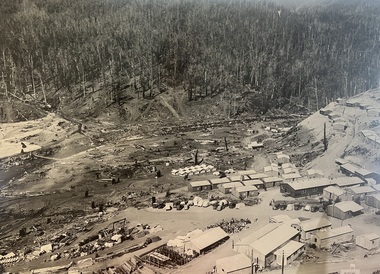 Falls Creek Historical Society
Photograph - Aerial View of Bogong Alpine Village
The images in the Bogong Village Collection were displayed in Bogong Jack’s Tavern for over 20 years and were donated to the Falls Creek Museum when the Tavern closed in 2021. In 1939, the State Electricity Commission of Victoria established a field headquarters at Bogong to house workers and their families for the Kiewa Hydroelectric Scheme which ran from the 1930s to the 1960s. The workmen's camp was originally started with tents and was called Junction Camp. By 1947, the village supported 300 workers and their families. It included 40 houses, a hostel for single staff, a post office, a police station, a medical centre, and a primary school. The staff hostel was known as Kiewa House. At the completion of the Scheme, in the 1960s, the village was opened to public/tourism use. In 1968 the Victorian Education Department acquired the camp buildings and four houses from the State Electricity Commission of Victoria to establish an Outdoor Education Centre which operated for over 50 years. The Kiewa Hydroelectric Scheme was privatized in the 1990s and sold to Southern Hydro, before being acquired by AGL in 2005. In 2023 the Grollo Group signed a 73 year sublease on Bogong Village and has plans for its redevelopment as a workers’ village.These images are significant because they capture the development of Bogong Village as an important element of the Kiewa Hydroelectric Scheme in Victoria.An aerial view of Bogong Village and surrounds, date unknown.bogong alpine village, bogong high plains, aerial photos bogong village -
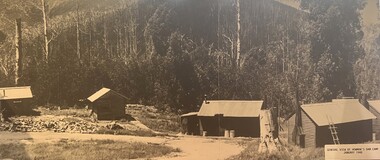
 Falls Creek Historical Society
Photograph - Bogong Alpine Village 1940
The images in the Bogong Village Collection were displayed in Bogong Jack’s Tavern for over 20 years and were donated to the Falls Creek Museum by the Liz Krien & the Bogong Village Trust Board when the Tavern closed in 2021. In 1939, the State Electricity Commission of Victoria established a field headquarters at Bogong to house workers and their families for the Kiewa Hydroelectric Scheme which ran from the 1930s to the 1960s. The workmen's camp was originally started with tents and was called Junction Camp. By 1947, the village supported 300 workers and their families. It included 40 houses, a hostel for single staff, a post office, a police station, a medical centre, and a primary school. The staff hostel was known as Kiewa House. At the completion of the Scheme, in the 1960s, the village was opened to public/tourism use. In 1968 the Victorian Education Department acquired the camp buildings and four houses from the State Electricity Commission of Victoria to establish an Outdoor Education Centre which operated for over 50 years. The Kiewa Hydroelectric Scheme was privatized in the 1990s and sold to Southern Hydro, before being acquired by AGL in 2005. In 2023 the Grollo Group signed a 73 year sublease on Bogong Village and has plans for its redevelopment as a workers’ village.These images are significant because they capture the development of Bogong Village as an important element of the Kiewa Hydroelectric Scheme in Victoria.A collection of 10 black and white images capturing the development of Bogong Alpine Village. They depict development of the new village, the surrounding area and some staff members during 1940.bogong alpine village, bogong 1940, bogong high plains