Showing 2137 items
matching map of bendigo
-
 Bendigo Historical Society Inc.
Map - TOWNSHIP OF SANDHURST MAP
... Inc. History House 11 Mackenzie Street Bendigo goldfields Map ...Map township of Sandhurst Portion B Bendigo Creek. Victoria zincographed at the Crown land's office, nos 54/21-57/12 Melbourne, April 21st 1857 (by G. Collis). -
 Bendigo Historical Society Inc.
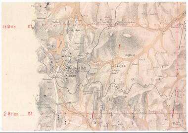
Map - DIAMOND HILL AREA
Copy of map of Diamond Hill area, with the Trig Station mid centre on map. Shafts, mines and geological features are marked.bendigo, mining, diamond hill -
 Bendigo Historical Society Inc.
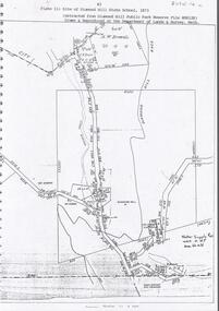
Document - DIAMOND HILL STATE SCHOOL SITE
Map (copy) showing the site of Diamond Hill State School, 1873. On top of page 'extracted from Diamond Hill Public Park Reserve File RS8128, drawn and reproduced at the Department of Lands and Survey, Melbourne'bendigo, education, diamond hill state school -
 Bendigo Historical Society Inc.
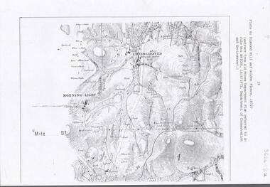
Document - DIAMOND HILL AREA MAP
... BENDIGO Mining diamond hill Map copy, 2 pages, from 'Old Mines ...Map copy, 2 pages, from 'Old Mines Department Plan, Dept of Conservation and Environment File No W91006, 16.6.1972' Map shows Golden Gully area with 'Town and Country Hotel' on north side and further south, with shafts and mine names marked.bendigo, mining, diamond hill -
 Bendigo Historical Society Inc.
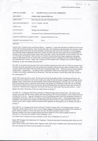
Document - GOLDEN GULLY ALLUVIAL WORKINGS
Golden Gully alluvial workings, Diamond Hill area, site number 1.1. Document has map/grid references, parcel number and location - runs along Woodward Road. History from 1851 to 186 detailed. . Information from David Bannear's Bendigo goldfields survey. -
 Bendigo Historical Society Inc.
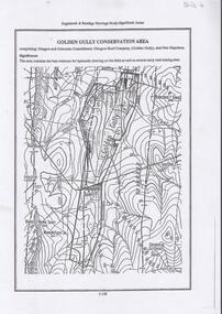
Document - DIAMOND HILL, GOLDEN GULLY COSERVATION AREA
... BENDIGO Mining golden gully Map of Golden Gully conservation area ...Map of Golden Gully conservation area comprising Glasgow and Golconda Consolidated, Glasgow Reef Company (Golden Gully) and New Napoleon. The area is significant because it contains the 'best evidence for hydraulic sluicing on the field as well as several early reef mining sites' On top of page 'Eaglehawk & Bendigo Heritage Study, Significant areas' Mines marked on page: Goldfields Extended shaft South Concord shaft Concord shaft Morning Light shaft Hansel and Mundy shaftbendigo, mining, golden gully -
 Bendigo Historical Society Inc.
Document - STAFFORD REEF MINE SITE, DIAMOND HILL
One page document describing the Stafford Reef Mine Site, Diamond Hill, Site 4.11, prepared by David Bannear. Information includes the map/grid references of the site and an overview of the history of the Stafford Reef Mine. The physical remains of the mine are described..bendigo, mining, stafford reef mine -
Bendigo Historical Society Inc.
Document - DIAMOND HILL HISTORIC AREA PARKS VICTORIA
Document, two pages, prepared by Parks Victoria in relation to the Diamond Hill Historic Area. Contains information regarding the history of the area; German Miners; Plants and animals. On second page is a map of the area showing historic features: Deborah Consolidated Gold workings Red, White and Blue Extended gold workings Goldfields Extended gold workings Dead Dog Gully, alluvial gold workings Glasgow & Golconda Gold workings and tramway Surface gold mining site Hansel Mundy gold workings Bendigo Goldfields Pty gold workings Stafford gold workings Langdon gold workings Great Opossum Gully alluvial gold workingsbendigo, mining, diamond hill -
 Bendigo Historical Society Inc.
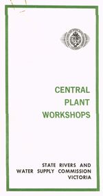
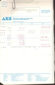
Document - STATE RIVERS AND WATER SUPPLY COMMISSION VICTORIA : CENTRAL PLANT WORKSHOPS
State Rivers and Water Supply Commission of Victoria. Brochure titled 'Central Plant Workshops'. Double-sided, three pages on each. Information about the workshops (CPW for short) and the setting up of the Bendigo site from 1946. There is a map of the layout of the site, and information given under the following headings - Central Plant Workshops, Work of the CPW, Meter Wheels, Pump Station Equipment, Steel Fabrication, Precast Concrete, and the Area and its Equipment. The brochure is dated June, 1968.state infrastructure, water supply, coliban system, state rivers and water supply commission of victoria. coliban system. central plant workshops. -
 Bendigo Historical Society Inc.
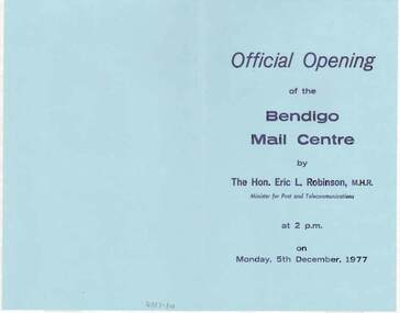
Document - DOCUMENT - OFFICIAL OPENING OF THE BENDIGO MAIL CENTRE, 05/12/1977
The Victorian Mail Network brochures, two with Official Opening of the Bendigo Mail Centre Programs. The Opening took place on Monday, 5th December, 1977.In the program are some Postal Historical notes and the program for the day. The brochure Victorian Mail Network has a map of the postal districts of Victoria with Country and Metropolitan Mail Centres and some notes on the front. On the inside, is another map from Kyneton - Echuca, Robinvale, Wentworth, Ouyen and to Bendigo via Charlton. Also Castlemaine. It has a list of the Benefits of the Scheme. On the back is a table, Standard of Service - Final posting times.bendigo, institutions, bendigo post office, document, official opening of the bendigo mail centre, the hon. eric l. robinson, m.h.r., joseph cusworth, sir john nimmo, john w henderson, r j page, cr r f turner, c g primmer, j w bourchier, b coughlan -
 Bendigo Historical Society Inc.
Document - OLD PEOPLES WELFARE SOCIETY COLLECTION: BANK STATEMENTS
COLLECTION OF RECORDS OF BENDIGO AND DISTRICT OLD PEOPLES WELFARE SOCIETY / Manilla folder / writing note on front B.O.P.W.S.Salvation Army , St Lukes , St Vincents De Paul , Bendigo Uniting Church Outreach , Notice to Members / inside includes news clippings , Bank statements , passbook , letters / history of the society , mention of founder Ken Hesse , Annual Return , Rules , map of Golden Oaks Villagedocument, ken hesse -
 Bendigo Historical Society Inc.
Book - ALEC H CHISHOLM COLLECTION: BOOK ''HISTORY OF THE KELLY GANG & THEIR PURSUERS'' BY J.J.KENNEALLY
Book. ALEC H CHISHOLM COLLECTION. 306 softcover book by J. J. Kenneally called 'The Complete Inner History of the Kelly Gang and their Pursuers'. Foreword by G. C. Stanley with several B & W photos and drawings of locations and characters and one map of Kelly country. Published and printed in 1934 by H. Hearne & Co, Pty. Ltd., Melbourne. Catalogue sticker ''2191 KEN'' on spine.J. J. Kenneallybooks, collections, history, alec h chisholm collection, ned kelly, kelly gang, j.j.kenneally, history -
Bendigo Historical Society Inc.
Book - THE AUSTRALIAN BOY SCOUT DIARY 1933, 1933
The Australian Boy Scout Diary 1933. Inside front cover is an intimate picture of Chief & his family. With specially written notes and Sketches for Cubs, Scouts, Rovers and Scouters. Obtainable at all State Headquaters in Australia. Prepared and Published by the Victorian Section in conjuntion with the Federal Scout Council of Australia. Printed by Exchange Press Pty Ltd, 310 Spencer Street, Melbourne. Index: Boy Scouts. Bush Fires. Calendars 1933, 1934. 1934 Calendar. Conventional Signs and Maps. Fires. First Aid. Headquaters Address. Holidays. Knots, Bends and Hitches. List of Badges. Local Fixtures. Morse. Our Flag. Personal Memoranda. Pioneering. Plan of Camp. Rover Scouts. Scout Uniform. Scout Signs and Salutes. Sea Scouts. Sea Scouting - Notes on Boat Handling. Semaphore. South by the Stars. Swimming. Torch. Treatment of Snakebite. Troop Camps. Weights and Measures. Wolf Cubs. Wood Badge. Uses of Scout Staff. Inside rear cover is a sepia photo of the site of the 1933 Jamboree at Godollo, Hungary. Book is very detailed giving information on all aspects of Scout life, with sketches for knots, maps, etc. Inscriptions are on page 58: Troup or Pack - 1st Epsom Pack. Watch No. 4133033. Season Ticket No. Commonwealth acc 957. Savings No. 4729. Size in Hats: 7. Size of Boots: 5. Size of Collar 14 1/2. Size of Gloves 6 1/4. Iinscription on page 60: Books Read: In Search of Wales, Morton. Faraway, Priestly. Jock the Scot, Alice Grant Rosemary. Bernard Shaw, Frank Harris.Exchange Press Pty Ltd., Melbournebook, bendigo, scouts, the australian boy scout diary 1933. photo of chief & his family. notes and sketches for cubs, scouts, rovers and scouters. obtainable at all state headquarters in australia. published by the victorian section in conjunction with the federal scout council of australia. exchange press pty ltd, melbourne. index: boy scouts. bush fires. calendars 1933, 1934. 1934 calendar. conventional signs and maps. fires. first aid. headquarters address. holidays. knots, bends and hitches. list of badges. local fixtures. morse. our flag. personal memoranda. pioneering. plan of camp. rover scouts. scout uniform. scout signs and salutes. sea scouts. sea scouting - notes on boat handling. semaphore. south by the stars. swimming. torch. treatment of snakebite. troop camps. weights and measures. wolf cubs. wood badge. uses of scout staff. sepia photo of the site of the 1933 jamboree at godollo, hungary. information on all aspects of scout life, with sketches for knots, maps, etc. inscriptions page 58: troup or pack - 1st epsom pack. watch no. 4133033. season ticket no. commonwealth acc 957. savings no. 4729. size in hats: 7. size of boots: 5. size of collar 14 1/2. size of gloves 6 1/4. page 60: books read: in search of wales, morton. faraway, priestly. jock the scot, alice grant rosemary. bernard shaw, frank harris. -
Bendigo Historical Society Inc.
Map - NEW CHUM & VICTORIA LINES OF REEF - PLAN OF NEW CHUM & VICTORIA LINES OF REEF
... Inc. History House 11 Mackenzie Street Bendigo goldfields MAP ...Two pages of a Plan of New Chum & Victoria Lines of Reef, compiled by G. W. Hart. Taken from J. N. Macartney's G'Fields Registry for 1871. Plan shows leases from High Street to California Gully. Location of the Manchester Arms, British & American Hotel and the Quartz Miners Arms are shown. Townships of Long Gully and Ironbark are shown.map, goldfields, new chum & victoria lines of reef, plan of new chum & victoria lines of reef, victoria catharine g m coy, thornton & co, extd victoria reef g m co, ural tribute compy, nil desperandum compy, koch, north victoria g m co, danger hill coy, north endeavour coy, wheadon & co, pilot co, north energetic co, energetic compy, endeavour company, hercules co, victoria gold mines compy, iron duke g m co, golden fleece united, ballerstedt, alfred co, confidence co, prince alfred co, canterbury co, advance co, wells, humboldt co, adventure co, try me well, sterry & co, gibbs & ballerstedt, handy andy, wells?, south adventure co, w rae, victoria reef quartz m co, myra co, jackson, wybrants, burrows & sterry, new chum & victoria tribute, old chum co, ballerstedt, lazarus, watson, koch & hildebrand, lansell & hunt, dennis, abe lincoln co, bonati & co, ellesmere co, moore late menzies, british co, british tribute co, garibaldi, c c co, new chum trib, dobson & co, young chum co, little chum co, old chum co, new chum trib, little chum trib, g w hart, j n macartney's g'fields registry for 1871, manchester arms, british & american, quartz miners arms -
 Bendigo Historical Society Inc.
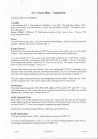
Document - NEW ARGUS MINE - NOTES ON THE NEW ARGUS MINE
One handwritten and four typed copies of notes on the New Argus Mine at Eaglehawk. One typed copy has a locality map attached. Notes mention locality, depth of shaft, early history, prominence, amou;nt of gold obtained and production. References; Special Edition Australian Mining Standard 1/6/1899, Mines Dept. Booklet 'Bendigo Goldfield' 1936, Mines Department Annual and Special Reports, Annals of Bendigo Mining Section 1886 - 1922 and A. Richardson. 4 Typewritten copies of this item have not been scanned.document, gold, new argus mine, new argus mine, notes on the new argus mine, eaglehawk, specimen hill mine, mr cave, mr amos, the argus mine, north specimen hill mine, adlinga and pascoe & co, new hopeful, bendigo amalgamated goldfields, special edition australian mining standard 1/6/1899, mines dept. booklet 'bendigo goldfield 1936, mines dept. annual and special reports, annals of bendigo mining section 1886 - 1922, a richardson -
 Bendigo Historical Society Inc.
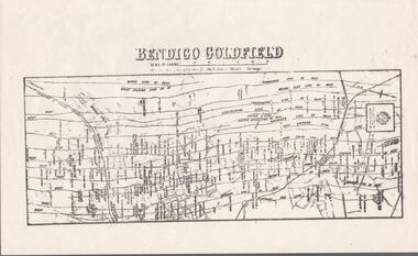
Map - BENDIGO GOLDFIELD MAP
... BENDIGO GOLDFIELD MAP...Bendigo Goldfield Map...Two not very clear copies of the Bendigo Goldfield Map... Inc. History House 11 Mackenzie Street Bendigo goldfields MAP ...Two not very clear copies of the Bendigo Goldfield Map. Streets, Railway Line, Lines of Reefs and mines are shown. Dept. of Mines, Victoria printed on the map. Shows reefs from Bird's Line of Reefs to Lightning Hill Line of Reef.map, bendigo, goldfields, bendigo goldfield map, lines of reefs, dept. of mines victoria -
Bendigo Historical Society Inc.
Map - UNDERGROUND SECTION OF 3 MINES
... Bendigo Historical Society Inc. Bendigo Historical Society ...Underground section of three mines - Shaft No 94, New Chum United Co, Cross Section No 89 - Shaft No 93, Lansell's 222 (DENIS), Cross Section No 87 - Shaft No 92A (New Shaft), Lansell's 222, Cross Section No 86. Map shows depth of cross sections below the sill and stone encountered. Poppet legs are drawn at the top of the shafts. Lansell's 222 Shaft No 92A has measurements pencilled in.mining, parish map, new chum united, lansell's 222 (denis), lansell's 222 -
 Bendigo Historical Society Inc.
Book - THE LADIES CLAIM TO FAME
The Ladies Claim to Fame, the story of Margaret Kennedy & Julia Farrell, 26 pages with black and white photographs and a map.Rita Hullcottage, miners -
 Bendigo Historical Society Inc.
Document - LADY BARKLY MINE - NOTES ON THE LADY BARKLY MINE
One hand written and four typed copies of notes on the Lady Barkly Mine on the New Chum Line of Reef. Hand written copy has a small hand drawn locality map and a reference list attached. Notes include localilty, depth of shaft, size of lease, Plant. Battery was shared by The South St Mungo Mine, Early History, Prominence, Production and Reference. First year of production 1864 and last year of production 1907. One typed copy signed by A Richardson 29 Harrison St Bendigo. 4 typewritten copies not scanned.document, gold, lady barkly mine, lady barkly mine, st mungo group, snobs' hill, sadowa shaft, st mungo shaft, lady barkly, special edition aust. mining standard 1/6/99, mines dept booklet 'bendigo goldfield 1936, mines dept annual and quarterly reports, annalso fbendigo mining section 1880 - 1908, a richardson, kilfoy and co, robbins & co, ringale and north devonshire cos -
Bendigo Historical Society Inc.
Map - HUSTLER'S & CHRISTMAS LINES OF REEFS - PLAN OF LINES OF SECTION OF REEFS
... Bendigo Historical Society Inc. Bendigo Historical Society ...Underground Survey of Mines Bendigo. Plan of Cross Section Lines Shewing Connections with Trigonometrical Stations and Base Lines. 13/3/99 Signed ? Stirling. Places and mines mentioned Speciman Hill, Tambour Major, Lansell's 180, Victory and Pandora, Great Extended Hustler's, Windmill Hill on Victoria Reef. Next part of map is a Plan of Lines of Section between the Hustler's and Christmas Lines of Reefs. 8/3/99. Signed ?. Transverse Section. Shows Tambour Major Co., near the Christmas Line of Reef, Crosscuts and their depth, geological features and stone encountered. Then shows Thistle Line, Charshalton Line, Napoleon Line, Nell Gwynne Line, New Chum Line, Lansell's No 180 with levels, depths and geological features. Drawing is continued in three parts to fit on paper. Lansell's East Shaft with levels and depths, geological features and stone encountered. Sheepshead Line, Old Shaft, Garden Gully Line, Victory and Pabndora Co with crosscuts, depths, geological features and stone encountered. Paddy's Gully Line, Derby Line, Millers Line, Hustler's Line, Great Extended Hustler's Co with levels, depths, geological features and stone encountered. A note beside a Saddle Reef: 360,000 pounds paid in dividends from this reef. Average ounces per ton gold noted where found. Reference Table for stone and geological features. Datum Line 700 feet above Sea Level Unscannedmining, parish map, hustler's & christmas lines of reefs, plan of lines of section of reefs, ? stirling, specimen hill, tambour major, lansell's 180, victory & pandora, great extended hustler's, windmill hill, victoria reef, tambour major co, christmas line, hustler's line, thistle line, carshalton line, napoleon line, nell gwynne line, new chum line, lansell's no 180, lansell's east shaft, sheepshead line, old shaft, garden gully line, paddy's gully line, derby line, miller's line, hustler's line, great extended hustler's co -
Bendigo Historical Society Inc.
Map - GREAT EXTENDED HUSTLER'S MINE - LONGITUDINAL SECTION OF THE GREAT EXTENDED HUSTLER'S MINE
... Bendigo Historical Society Inc. Bendigo Historical Society ...Longitudinal Section of the Great Extended Hustler's Mine on the Hustler's Line of Reefs. Bulletin No 33, Plate No XIII. Map shows the Hustler's Tribute, 2 Old Shafts, Great Extended Hustler's Shaft, Latham & Watson's Shaft and Ironbark Gully. Datum Line 750 feet above Sea Level. Poppet Legs on the surface and Sill of Shaft 788.99 feet above Sea Level. Levels and their depths are shown and some geographical features. Some amounts of gold mined mentioned. Geological Survey of Victoria emblem and signed by H A Whitelaw, Underground Survey Office Bendigo, September 1913. Note - Plates 4, 8, 13,20, 26 & 31 form a Longitudinal Section from Fortuna Hustlers to Hustler's Consols Mine. This item has not been scanned or photographed.mining, parish map, great extended hustler's mine, longitudinal section of the great extended hustler's mine, geological survey of victoria, underground survey office bendigo, h a whitelaw, hustler's tribute, old shaft, great extended hustler's shaft, latham & watson's shaft, ironbark gully -
Bendigo Historical Society Inc.
Map - GREAT EXTENDED HUSTLER'S MINE - TRANSVERSE SECTION OF THE GREAT EXTENDED HUSTLER'S MINE
... Bendigo Historical Society Inc. Bendigo Historical Society ...Transverse Section of the Great Extended Hustler's Mine on the Hustler's Line of Reef. Bulletin No 33, Plate No XII. Shows Poppet legs at the surface and Sill of Shaft at 788.99 feet above Sea Level, Cross Cuts and their depths, stone and geographical features encountered and their references and a number of enlarged drawing of sections of the cross cuts, Geological Survey of Victoria emblem and signed by H A Whitelaw, Underground Survey Office Bendigo, September 1913. The depths of crosscuts to No 21 were taken from plans of surveys by Mr Walker and Mr Craven, noted under Reference. Another note: This Saddle Reef is sketched from Mr Walker's plan. Dividends amounting to 360,000 pounds were obtained from it. This item has not been scanned or photographed.mining, parish map, great extended hustler's mine, transverse section of the great extended hustler's mine, old shaft, mr walker, mr craven, geological survey of victoria, underground survey office bendigo, h a whitelaw -
 Bendigo Historical Society Inc.
Map - GREAT EXTENDED HUSTLER'S MINE - PLAN OF THE GREAT EXTENDED HUSTLER'S MINE
... Bendigo Historical Society Inc. Bendigo Historical Society ...Plan of the Great Extended Hustler's Mine. Bulletin No 33, Plate No XI. Shows No 2 Shaft, Latham & Watson's Shaft, levels and their depths and some geographical features. Geographical Survey of Victoria emblem and signed by H A Whitelaw, Underground Survey Office, Bendigo, September 1913. Has reference to photos.mining, parish map, great extended hustler's mine, no 2 shaft, latham & watson's shaft, geological survey of victoria, underground survey office bendigo, h a whitelaw -
 Bendigo Historical Society Inc.
Map - GREAT EXTENDED HUSTLER'S MINE - PLAN OF THE GREAT EXTENDED HUSTLER'S MINE
... Bendigo Historical Society Inc. Bendigo Historical Society ...Plan of the Great Extended Hustler's Mine on the Hustler's Line of Reefs, Bendigo. Bulletin No 33, Plate No X. Lease No 7382. Plan has map of streets. Mine was located in the block bounded by Langston and Anderson Streets and was between the Hustler's Anticline at Surface and the Lightning Hill Anticline at Surface. Latham & Watson's Shaft is also mentioned. Levels are numbered and a table shows the Levels and their Depths. Geological Survey of Victoria. Signed by H A Whitelaw, Underground Suyrvey Office, Bendigo, September 1913. This item has not been scanned or photographed.mining, parish map, great extended hustler's mine, hustler's line of reefs, mining lease no 7382, geological survey of victoria, underground survey office bendigo, h a whitelaw, latham & watson's shaft -
Bendigo Historical Society Inc.
Map - FORTUNA HUSTLER'S MINE - TRANSVERSE SECTION OF THE FORTUNA HUSTLER'S MINE
... Bendigo Historical Society Inc. Bendigo Historical Society ...Transverse Section of the Fortuna Hustler's Mine on the Hustler's Line of Reef, Bendigo. Bulletin No 33, Plate No III. Drawing shows poppet legs on the surface and Sill of Shaft 745.38 feet above Sea Level. Shows levels and their depths, geographical features and stone encountered. Reference table to stone and geographical features. Geographical Survey of Victoria emblem. Signed by H A Whitelaw, Underground Survey Office, Bendigo. This item has not been scanned or photographed.mining, parish map, fortuna hustler's mine, hustler's line of reef, geological survey of victoria, underground survey office bendigo, h a whitelaw -
 Bendigo Historical Society Inc.
Map - FORTUNA HUSTLER'S MINE - LONGITUDINAL SECTION OF THE FORTUNA HUSTLER'S MINE
... Bendigo Historical Society Inc. Bendigo Historical Society ...Longitudinal Section of the Fortuna Hustler's Mine on the Hustler's Line of Reef, Bendigo. Bulletin No 33, Plate No IV. Shows poppet legs at the surface level, Datum Line 750 feet above Sea Level, levels and their depths, the amount of gold per ton and some geographical features. Geological Survey of Victoria emblem and signed by H A Whitelaw, Underground Survey Office, Bendigo. Note - Plates 4, 8, 13, 20, 26 & 31 form a Longitudinal Section from Fortuna Hustler's to Hustler's Consols Mine. This item has not been scanned or photographed.mining, parish map, fortuna hustler's mine, longitudinal section of the fortuna hustler's mine, geological survey of victoria, h a whitelaw, underground survey office bendigo, hustler's line of reef, hustler's consols mine -
 Bendigo Historical Society Inc.
Map - FORTUNA HUSTLER'S MINE - PLAN OF THE FORTUNA HUSTLER'S MINE
... , Underground Survey Office Bendigo, September 1913. Map shows levels...Bendigo Historical Society Inc. Bendigo Historical Society ...Plan of the Fortuna Hustler's Mine, Bulletin No 33, Plate No II. Geological Survey of Victoria. Signed by H A Whitelaw, Underground Survey Office Bendigo, September 1913. Map shows levels and depths. There are smaller drawings of some sections of some levels. This item has not been scanned or photographed.mining, parish map, fortuna hustler's mine, plan of the fortuna hustler's mine, geological survey of victoria, h a whitelaw, underground survey office bendigo -
Bendigo Historical Society Inc.
Map - HUSTLER'S CONSOLS MINE - TRANSVERSE SECTION OF THE HUSTLER'S CONSOLS MINE
... Bendigo Historical Society Inc. Bendigo Historical Society ...Transverse Section of the Hustler's Consols Mine Bulletin No 33, Plate No XXXIII. Map shows poppet legs at the surface and Sill of Shaft 779.42 feet above Sea Level. Shows the different levels and their depths and the different stone and geographical features encountered. Has larger drawing of Section A - B. Geographical Survey of Victoria. Signed by H A Whitelaw, Underground Survey Office Bendigo, September 1913. This Item has not been scanned or Photographed.mining, parish map, hustler's consols mine, transverse section of the hustler's consols mine, geological survey of victoria, underground survey office bendigo, h a whitelaw -
Bendigo Historical Society Inc.
Map - HUSTLER'S REEF MINE - TRANSVERSE SECTION OF THE HUSTLER'S REEF MINE
... Bendigo Historical Society Inc. Bendigo Historical Society ...Transverse Section of the Hustler's Reef Mine on the Hustler's Line of Reefs. Bulletin No 33, Plate No XVIII. Shows cross-cuts and their depth, different types of stone and geological features encountered. Drawing of poppet legs at the surface and Sill of Shaft 756.39 ft above Sea Level. Reference Table shows key to the different stone and geographical features encountered. Geographical Survey of Victoria. Signed by H A Whitelaw, Underground Survey Office, Bendigo, September 1913. Thompson's Reef is also mentioned on the map. This item has not been scanned or photographed.mining, parish map, hustler's reef mine, transverse section of the hustler's reef mine, geological survey of victoria, h a whitelaw, underground survey office bendigo, thompson's reef. -
 Bendigo Historical Society Inc.
Map - HUSTLER'S REEF MINE - EAST & WEST CROSS-CUTS, NORTH & SOUTH OF SHAFT
... Bendigo Historical Society Inc. Bendigo Historical Society ...East & West Cross-cuts, North & South of Shaft, Hustler's Reef Mine Bulletin No 33, Plate No XIX. Map shows main shaft and smaller drawing of section with different stone encountered. Also gives location in relation to the shaft, e. g. 225'E & 150'S of Shaft. Reference diagram to show the different stone and features encountered. Geological Survey of Victoria emblem. Signed by H A Whitelaw, Underground Survey Office Bendigo, September 1913. This item has not been scanned or photographed.mining, parish map, hustler's reef mine, east & west cross-cuts north & south of shaft, geological survey of victoria, h a whitelaw, underground survey office bendigo