Showing 17528 items
matching plenty-hotel
-
 Linton and District Historical Society Inc
Floor plan, Floor plan of Railway Hotel, Linton, 1953
Architectural drawing showing block and floor plan of Linton's Railway Hotel. The plan appears to have been drawn up for the Ballarat Brewing Company, which owned the hotel, in connection with proposed renovations. Plan is initialled "J. O. O'B." and dated"5.5.53". Plan shows bar area, parlours and dining rooms, residential areas, ablutions areas, staff bedrooms, rooms used for accommodation, and outbuildings (stable, garage etc.).railway hotel linton, maps and plans, floor plans -
 Upper Yarra Museum
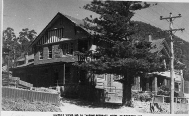
Negative Photographic Reproduction, PC Murray Views 14, Alpine Retreat Hotel Warburton
03053 PC Murray Views 14, Alpine Retreat Hotel Warburton Upper Yarra Shire 1888-1988 Centenary collection. Black & white Negative, scanned at 600 dpialpine retreat hotel warburton pc murray views 14 -
Port Melbourne Historical & Preservation Society
Drawing - Illustration, lasercopy, William Strutt, Shipping Cattle at Sandridge near Liardets Hotel 1850, 1850
One of two colour lasercopies of William Strutt watercolours reproduced in the Strutt album viewed in ths Victorian Parliamehntary Library: Shipping Cattle at Sandridge near Liardets Hotel 1850arts and entertainment - visual arts, livestock, transport - shipping, willaim strutt, wilbraham frederick evelyn liardet, wfe liardet, liardets beach -
Whitehorse Historical Society Inc.
Article, Heritage Protection for Hotel, 2015
An article with a photo of Vicki Jones-Evans supporting the heritage listing of the Burvale Hotel .An article with a photo of Vicki Jones-Evans supporting the heritage listing of the Burvale Hotel and related Facebook comments and information from Ray Wilcox regarding its sprayed concrete roof.An article with a photo of Vicki Jones-Evans supporting the heritage listing of the Burvale Hotel .burvale hotel, jones-evans, vicki -
 Eltham District Historical Society Inc
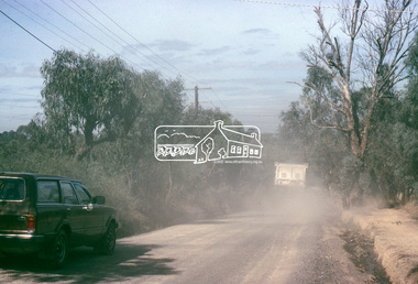
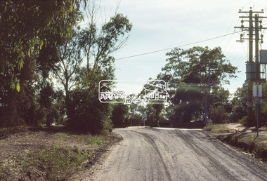
Slide, Bonds Road, Lower Plenty, Mar. 1981
One of a series of images of road infrastructure focussed on Bonds Road, Lower Plenty, the section connecting Old Eltham Road with Rosehill Road, taken by Eltham Shire Council Planning and Engineering officers. They provide perspective of the changes in housing styles and road development that began sweeping in from the mid 1970s with increasing urbanisation of what was once more outlying suburbs and regions. All images have been identified with GPS35 mm colour positive transparency (1 of 13) Mount - Kodak Kodachrome CardProcessed Mar 1981infrastructure, roads, bonds road, lower plenty, old eltham road -
 Eltham District Historical Society Inc
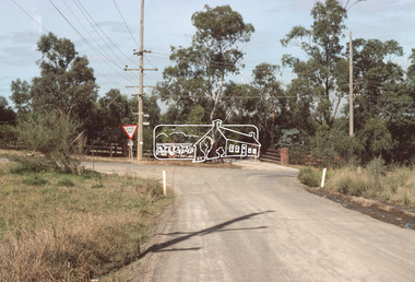
Slide, Bonds Road, Lower Plenty, Mar. 1981
One of a series of images of road infrastructure focussed on Bonds Road, Lower Plenty, the section connecting Old Eltham Road with Rosehill Road, taken by Eltham Shire Council Planning and Engineering officers. They provide perspective of the changes in housing styles and road development that began sweeping in from the mid 1970s with increasing urbanisation of what was once more outlying suburbs and regions. All images have been identified with GPS35 mm colour positive transparency (1 of 13) Mount - Kodak Kodachrome CardProcessed Mar 1981infrastructure, roads, bonds road, lower plenty -
 Eltham District Historical Society Inc
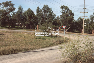
Slide, Bonds Road, Lower Plenty, Mar. 1981
One of a series of images of road infrastructure focussed on Bonds Road, Lower Plenty, the section connecting Old Eltham Road with Rosehill Road, taken by Eltham Shire Council Planning and Engineering officers. They provide perspective of the changes in housing styles and road development that began sweeping in from the mid 1970s with increasing urbanisation of what was once more outlying suburbs and regions. All images have been identified with GPS35 mm colour positive transparency (1 of 13) Mount - Kodak Kodachrome CardProcessed Mar 1981infrastructure, roads, bonds road, lower plenty -
 Eltham District Historical Society Inc
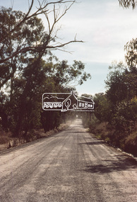
Slide, Bonds Road, Lower Plenty, Mar. 1981
One of a series of images of road infrastructure focussed on Bonds Road, Lower Plenty, the section connecting Old Eltham Road with Rosehill Road, taken by Eltham Shire Council Planning and Engineering officers. They provide perspective of the changes in housing styles and road development that began sweeping in from the mid 1970s with increasing urbanisation of what was once more outlying suburbs and regions. All images have been identified with GPS35 mm colour positive transparency (1 of 13) Mount - Kodak Kodachrome CardProcessed Mar 1981infrastructure, roads, bonds road, lower plenty -
 Eltham District Historical Society Inc
Slide, Bonds Road, Lower Plenty, Mar. 1981
One of a series of images of road infrastructure focussed on Bonds Road, Lower Plenty, the section connecting Old Eltham Road with Rosehill Road, taken by Eltham Shire Council Planning and Engineering officers. They provide perspective of the changes in housing styles and road development that began sweeping in from the mid 1970s with increasing urbanisation of what was once more outlying suburbs and regions. All images have been identified with GPS35 mm colour positive transparency (1 of 13) Mount - Kodak Kodachrome CardProcessed Mar 1981infrastructure, roads, bonds road, lower plenty, rosehill road -
 Eltham District Historical Society Inc
Slide, Bonds Road, Lower Plenty, Mar. 1981
One of a series of images of road infrastructure focussed on Bonds Road, Lower Plenty, the section connecting Old Eltham Road with Rosehill Road, taken by Eltham Shire Council Planning and Engineering officers. They provide perspective of the changes in housing styles and road development that began sweeping in from the mid 1970s with increasing urbanisation of what was once more outlying suburbs and regions. All images have been identified with GPS35 mm colour positive transparency (1 of 13) Mount - Kodak Kodachrome CardProcessed Mar 1981infrastructure, roads, bonds road, lower plenty -
 Eltham District Historical Society Inc
Slide, Bonds Road, Lower Plenty, Mar. 1981
One of a series of images of road infrastructure focussed on Bonds Road, Lower Plenty, the section connecting Old Eltham Road with Rosehill Road, taken by Eltham Shire Council Planning and Engineering officers. They provide perspective of the changes in housing styles and road development that began sweeping in from the mid 1970s with increasing urbanisation of what was once more outlying suburbs and regions. All images have been identified with GPS35 mm colour positive transparency (1 of 13) Mount - Kodak Kodachrome CardProcessed Mar 1981infrastructure, roads, bonds road, lower plenty, old eltham road -
 Greensborough Historical Society
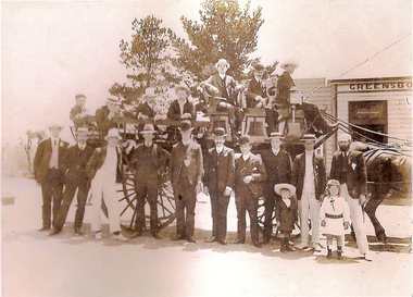
Photograph, Unknown, Picnic group at Greensborough Hotel, 1905_
Photograph shows group of men on horse-drawn dray in front of Greensborough Hotel.Another photograph of a picnic group in Greensborough.Copy of black and white photographpicnics, greensborough, greensborough hotel -
 Stawell Historical Society Inc
Photograph, Group of people in front of Stawell Coffee Palace, formerly the Castlemaine Hotel, 1937-1940
Group in front of Stawell Coffee Palace 1937-40 formerly Castlemaine Hotel,.stawell -
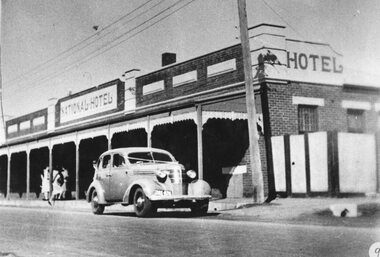
 Stawell Historical Society Inc
Photograph, M Jim Willoby and Mr Reece Unknown painting the National Hotel in Wakeham Street Stawell c1900
Jim Willoby and Reece painting the National Hotel Wakeham Street Stawell c1900stawell -
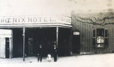 City of Ballarat Libraries
Photograph, Phoenix Hotel circa 1899
The Phoenix Hotel was situated opposite the Fire Station in Barkly Street, Ballarat East. phoenix hotel, barkly street, ballarat east -
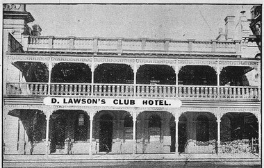 City of Ballarat Libraries
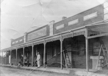
Photograph - Card Box Photographs, D. Lawson's Club Hotel, Ballarat 1914
The Club Hotel was located on Lydiard Street South near Her Majesty's Theatre.club hotel, d. lawson, building, hotel, commerical, public -
 Stawell Historical Society Inc
Photograph, Photo of Mr Will Rees's painting of The Reef Hotel Pleasant Creek with a Bullock team in front
Photo of Will Rees painting of The Reefs Hotel Pleasant Creek with Bullock team in front.stawell -
 Stawell Historical Society Inc
Photograph, National Hotel in Wakeham Street Stawell with a wedding vehicle parked in front c1940
National Hotel with wedding vehicle parked in front Wakeham Street Stawell c1940stawell -
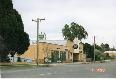 Stawell Historical Society Inc
Photograph, Railway Hotel in Lower Main Street Stawell 1999 -- Coloured
Colour photograph of Brick Railway Hotel Lower Main Street Stawell 1999stawell -
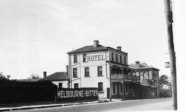 Stawell Historical Society Inc
Photograph, Royal Exchange Hotel & Court House in Patrick Street Stawell 1930
Royal Exchange Hotel Stawell with Court House in Patrick Street Stawell 1930stawell -
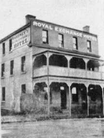 Stawell Historical Society Inc
Photograph, Royal Exchange Hotel with a verandah in Patrick Street Stawell near Court House
Royal Exchange Hotel with Verandah Patrick Street Stawell near Court Housestawell -
Unions Ballarat
Photograph: Julia Gillard and bar staff at the North Star Hotel, 15/4/07
Photograph: Julia Gillard and bar staff at the North Star Hotel Julia Gillard was Deputy Prime Minister at the time this photograph was taken. Gillard was a lawyer before entering politics. She was the 27th Prime Minister of Australia from 2010 to 2013 and the first female prime minister. Kevin Rudd successfully challenged Gillard's leadership in 2013 and he went on to lose the election. Julia Gillard resigned from parliament following the leadership challenge.Photographbtlc, ballarat trades hall, ballarat trades and labour council, gillard, julia, alp, australian labor party, prime minister, deputy prime minister, politicians -
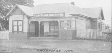 Ringwood and District Historical Society
Photograph, Coach and Horses Hotel, Whitehorse Road, Ringwood. 1924
Appears to be reproduction of newspaper photograph. South Side of highway.Written below one photograph, "Photo of Coach and Horses Hotel, corner of White Horse Road and Madden Street. Enter Estate at Madden Street". 1924. -
 Ringwood and District Historical Society
Book, Anita Barker, From the Ashes Children at the Coach & Horses Hotel, 2008
Ringwood Early Beginnings, Ringwood in the 1890's, Childhood and the people at The Coach & Horses Hotel - Thesis submitted as part of the Final Honours Examination in the Archaeology Program La Trobe University 2008 +Additional Keywords: Anita Barker. Hard-bound copy 124 pages with digital addenda CD of Artefact Catalogue & Photograph Catalogue. (CD copied to RDHS Library Master Images - File Ref: 4424 Coach and Horses Hotel Addenda CD)