Showing 25590 items matching "plenty-township-estate"
-
 Eltham District Historical Society Inc
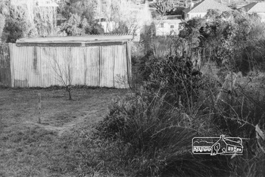
Photograph, Possibly at the end of Maskell Crescent, Lower Plenty, c.July 1967, 1967
Packaged in "Filmpro King Size prints Definitely Better EST. 1918" envelope. Pencil notes: 36 shots $2.87 Eltham Shire J. McD and 19/7/67. Alma Street and Kett Street Lower Plenty c.July 1967.Black and white photographlower plenty, houses, streets, maskell crescent -
 Eltham District Historical Society Inc
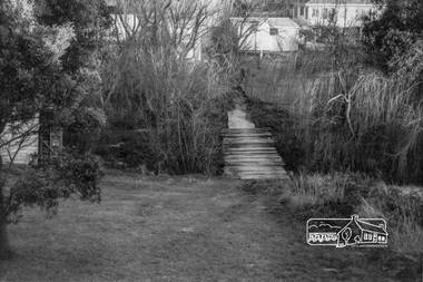
Photograph, Possibly at the end of Maskell Crescent, Lower Plenty, c.July 1967, 1967
Packaged in "Filmpro King Size prints Definitely Better EST. 1918" envelope. Pencil notes: 36 shots $2.87 Eltham Shire J. McD and 19/7/67. Alma Street and Kett Street Lower Plenty c.July 1967.Black and white photographlower plenty, houses, streets, maskell crescent -
 Eltham District Historical Society Inc
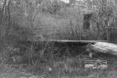
Photograph, Possibly at the end of Maskell Crescent, Lower Plenty, c.July 1967, 1967
Packaged in "Filmpro King Size prints Definitely Better EST. 1918" envelope. Pencil notes: 36 shots $2.87 Eltham Shire J. McD and 19/7/67. Alma Street and Kett Street Lower Plenty c.July 1967.Black and white photographlower plenty, houses, streets, maskell crescent -
 Eltham District Historical Society Inc
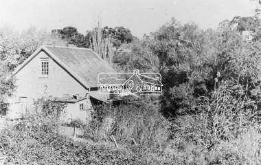
Photograph, Willis Vale on the north bank of the Plenty River, Church Street, Greensborough, c.1950
Photo sourced from Heidelberg Historical Society reproduced on p63 of The Diamond Valley Story by Dianne H. Edwards, Shire of Diamond Valley 1979. "Willis Vale, Greensborough, situated on the north bank of the Plenty River at the end of Church Street. The home wasa built about 1840 by Jame Willis Mayger from bricks hand-made nearby. It was later passed to the Partington family and when this photo was taken the building was deserted. Vandals and finally a bushfire destroyed Willis Vale in the 1950s." Greensborough Historical Society has same image with more accurate information on the date/cause of fire damage https://victoriancollections.net.au/items/585b6c96d0ce2c1268f1c96b "House built by Edward Maygar, Robert Whatmough lived there mid 19th century and later sold to Partington family. It was located on the Plenty River at Partington's Flat Greensborough. The derelict Willis Vale house was destroyed in 1964 when a fire originating from North Plenty Gorge - Kurrak Road - was lit by two teenage boys and made its way several kilometres down to Partington's Flat Greensborough."Black and white copy of photo printed on glossy photographic paper 30.5 x 40.5 cm (12 x 16 inch); image size approx. 18.5 x 28 cmchurch street, diamond valley story, greensborough, james willis mayger, partington family, willis vale -
 Greensborough Historical Society
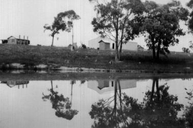
Photograph - Digital image, John McLaughlin's Plenty, 1933, 1933_
Part of a collection of photographs owned by Dorris McLaughlin who was born in Greensborough, in 1899 to John McLaughlin and Rosalie Ellen Whatmough. The collection contains photographs of friends and relatives from the Greensborough and Eltham areas. This photograph shows farm buildings at Plenty reflected in water.Digital copy of black and white photograph.dorris mclaughlin, john mclaughlin, plenty -
 Greensborough Historical Society
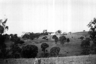
Photograph - Digital image, John McLaughlin's Paddock, Plenty, 1934, 1933_
Part of a collection of photographs owned by Dorris McLaughlin who was born in Greensborough; in 1899 to John McLaughlin and Rosalie Ellen Whatmough. The collection contains photographs of friends and relatives from the Greensborough and Eltham areas. This photograph shows part of John McLaughlin's Plenty property.Digital copy of black and white photograph.dorris mclaughlin, john mclaughlin, plenty -
 Ringwood and District Historical Society
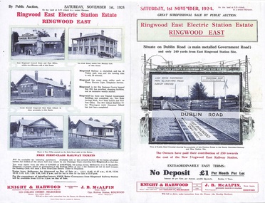
Flyer, Land Sale Auction Brochure, Electric Station Estate, Ringwood East, Vic. - 1924
Folded double-sided advertisement for Ringwood East Electric Station Estate subdivisional sale of retail and residential allotments by public auction on Saturday, 1 November, 1924, with local photographs, terms of sale, and summary of subdivision features and local facilities. Subdivision includes Railway Parade (later Patterson Street, Rosedale Crescent, Federal Road, Howship Avenue (later Howship Court and French Street), and Dublin Road. (Agents) Knight & Harwood, 315 Collins Street, Melbourne, Phone Central 10615, 10616, in conjunction with J.B. McAlpin, Opposite Railway Station, Ringwood, Phone Ringwood 7. -
 Whitehorse Historical Society Inc.
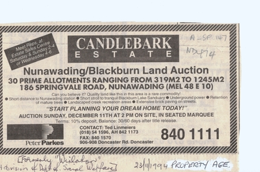
Document, Candlebark Estate, 27/07/1994 12:00:00 AM
Advertisement of auction of 'Candlebark Estate'.Advertisement of auction of 'Candlebark Estate'. 30 allotments, 186 Springvale Road, Nunawading., 11 December 1994. Agents: Peter Parkes. Former site of 'Winlaton', division of Dept. of Social Welfare. In the Age Property Section 23 November 1994.Advertisement of auction of 'Candlebark Estate'. candlebark estate, nunawading, winlaton, springvale road, land subdivision -
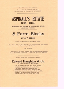 Whitehorse Historical Society Inc.
Pamphlet, Aspinall's Estate Box Hill, 1937
Pamphlet advertising 8 farm blocks on Aspinall Estate,Pamphlet advertising 8 farm blocks on Aspinall Estate, Box Hill on Woodhouse Grove and Aspinall Road, 27 October 1937. Sale was for the City of Box Hill and the Shire of Blackburn and Mitcham.. A plan is included. A list of other sales is on the verso.Pamphlet advertising 8 farm blocks on Aspinall Estate,auctions, aspinalls estate, abattoirs paddock, woodhouse grove, box hill north, aspinall road, mont albert, box hill, surrey hills, burwood, edward haughton pty ltd, t. r. b. morton & son, cameron and speed, f. j. sides, weston and unmacht, edmund dawson, h. carey sutton (estate agent), j. i. doeg, city of box hill, shire of blackburn and mitcham -
 Kew Historical Society Inc
Plan - Subdivision Plan, Tregarron Estate, Kew, c.1929
Pru Sanderson, in her groundbreaking ‘City of Kew Urban Conservation Study : Volume 2 - Development History’ (1988), summarised the periods of urban development and subdivisions of land in Kew. The periods that she identified included 1845-1880, 1880-1893, 1893-1921, 1921-1933, 1933-1943, and Post-War Development. These periods were selected as they represented periods of rapid growth or decline in urban development. An obvious starting point for Sanderson’s groupings involved population growth and the associated economic cycles. These cycles also highlighted urban expansion onto land that was predominantly rural, although in other cases it represented the decline and breakup of large estates. A number of the plans in the Kew Historical Society’s collection can also be found in other collections, such as those of the State Library of Victoria and the Boroondara Library Service. A number are however unique to the collection.Subdivision plans are historically important documents used as evidence of the growth of suburbs in Australia. They frequently provide information about when the land was sold on which a built structure was subsequently constructed as well as evidence relating to surveyors and real estate and financial agents. The numerous subdivision plans in the Kew Historical Society's collection represent working documents, ranging from the initial sketches made in planning a subdivision to printed plans on which auctioneers or agents listed the prices for which individual lots were sold. In a number of cases, the reverse of a subdivision plan in the collection includes a photograph of a house that was also for sale by the agent. These photographs provide significant heritage information relating house design and decoration, fencing and household gardens.In January 1929, the Kew City Council called for tenders to construct Tregarron Avenue. The subdivision of the Tregarron Estate in Kew was for 11 lots bordering Tregarron Avenue and its entrance from Burke Road. The plan includes annotations that indicate the measurement of each block and the placement of the drainage and sewerage easements. This plan is interesting for a number of factors. The house blocks today have different street numbers, some blocks were to be further subdivided, and at the time of the subdivision, alterations were still being made to the extent of lots offered; lots 2 and 3 on the plan were subdivided and reoriented.subdivision plans - kew, tregarron estate, tregarron avenue -- kew (vic.), burke road -- kew (vic.) -
 Ringwood and District Historical Society
Photograph, Landys home (formerly Patersons). Byways estate area (East Ringwood). 5 Views. (c1968)
SS0261 is the covering letter from Beth Little, dated 31/3/1969, which states: "Please fined enclosed the photographs I took of Landy's 80 yr. old home which was moved just before last Christmas to another site on their estate...it was built by some people by the name of Patterson and originally included the Byways Estate and other land which extended up to about Lillis Crt. The land known as Byways Estate was sold off to a Mr Best by a later owner so far as I can find out.." Written on back of photographs: SS0261a:From about where the feed shed was. SS0261b:Looking up driveway towards the east. Landys home (formerly Patersons). Byways estate area (East Ringwood) SS0261c:Eastern side of house (officially the front). SS0261d:Stable and feed shed now demolished. Wooden tank on right-hand side. SS0261e:Southern side. Well to left of far end of house wall -
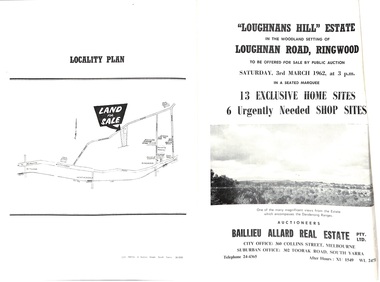 Ringwood and District Historical Society
Document - Folder, Subdivision Auction - Loughnans Hill Estate 1962, Ringwood, Victoria
Double-sided bifold page advertising auction on Saturday 3rd March, 1962 - 13 residential allotments in Hearthside Court and 6 shop sites in Loughnan Road, with map of subdivision, terms of sale, and summary of features and services. Adjoining service station shown on accompanying Plan of Subdivision - Part of Crown Allotment 28 Parish of Warrandyte, also showing location of property known as "Hearth", hence Hearthside Court.Auctioneers - Baillieu Allard Real Estate Pty Ltd., 360 Collins Street, Melbourne, and 302 Toorak Road, South Yarra. Telephone 24-4365, After hours XU1549, WL2471. -
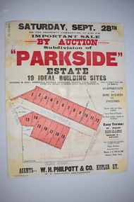 Warrnambool and District Historical Society Inc.
Work on paper - Original Document, H J Paynter, Advertisement "Parkside"Estate subdivision, Circa 1935
This sheet denotes an auction of land which is situated close to Albert Park on the northern part of Warrnambool. The area is complete now with homes which are a mixture of brick and concrete faced houses. The agent W H Philpott was operating in Warrnambool from the 1930's though to 1950'sThis item has local interest and significance as it records the sale of Warrnambool land.Large white paper sheet with black and red text. The auction details are at the top and down the righthand side with a map of the available blocks are coloured red and outlined in black.Parkside estate, W H Philpott & Co Kepler St , R V Philpott auctioneer,Solicitors J S Tait & son. Cramer Street, Nelson Street McConnell Street.warrnambool, mcconnell street warrnambool -
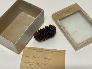 Creswick Campus Historical Collection - University of Melbourne
Plant specimen - Plant Specimen from the VSF Herbarium, Picea bicolor. Cultivated Hayes Estate. Lexington, Mass
Plant Specimen from the VSF Herbarium - seeds in a cardboard box with a glass lidBox: Picea bicolor. Cultivated Hayes Estate, Lexington Mass. Note inside: Herbarium of the Arnold Arboretum Harvard University. Picea bicolor mayr. (collector) C.E.Faxton Nov. 1, 1909 -
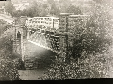 Greensborough Historical Society
Photograph, Plenty River Bridge Greensborough, 1910c
Early photograph of Main Street bridge over the Plenty River, taken around 1910. Quirk's Tailor shop is seen in the background and a horse and cart coming down the road. The road appears unsealed. Rampant blackberries can be seen growing around the bridge abutments. Part of a collection of photographic enlargements of Greensborough sites.Black and white enlargement of photographic imagemain street bridge, main street greensborough, plenty river greensborough, quirk's tailor shop, blackberry, mckenzie bridge -
 Greensborough Historical Society
Photograph - Digital image, Group Playing Tennis at Plenty, 1933, 1933_
Part of a collection of photographs owned by Dorris McLaughlin who was born in Greensborough, in 1899 to John McLaughlin and Rosalie Ellen Whatmough. The collection contains photographs of friends and relatives from the Greensborough and Eltham areas. This photograph shows a group of people playing tennis at Plenty, 1933.Digital copy of black and white photograph.dorris mclaughlin, plenty -
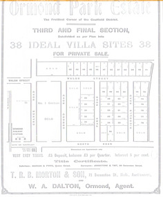 City of Moorabbin Historical Society (Operating the Box Cottage Museum)
Flyer - Ormond Parke Estate, Ormond, 1913
At the end of World War One, there was a renewed interest in residential land and a number of estates opened up in the Municipality of Moorabbin.Example of the progress of the Municipality of MoorabbinPhotocopy of advertising flyer for private sale of real estate sales - plan of building blocks for saleOrmond Parke Estate, Ormond - Third and final section for private salewalsh st, ormond road, park road, nicholls road, ormond, real estate -
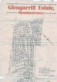 Greensborough Historical Society
Map, Glengarriff Estate Montmorency, 1938c
Estate Agent's plan of Glengarriff Estate, Montmorency, covering LPs 11334 and 11451. Bordered by Sherbourne Avenue, Calrossie Avenue, Montmorency Station and Price AvenueColour photocopy of subdivision map, on two A3 sheets glengarriff estate montmorency, sherbourne avenue montmorency, calrossie avenue montmorency, price avenue montmorency, montmorency station -
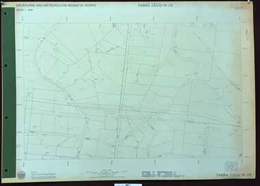 Greensborough Historical Society
Map, Melbourne and Metropolitan Board of Works. Survey Division, MMBW, Yarra 2500 / 14.25. Plenty, Heard Road, 1978_02
Melbourne and Metropolitan Board of Works. Yarra 2500 [base map] 14.25. Plenty, Heard Road. Parishes of Greensborough 2724, Nillumbik 3310 and Morang 3183. Municipality of Diamond Valley 257. Prominent streets include: Heard Road, Seymour Drive and Yan Yean Road.MMBW Map in 1:2500 [scale] series. Cream parchment with green tape reinforcing on edges and punched holes on left edge.mmbw, melbourne and metropolitan board of works, shire of diamond valley, plenty - maps -
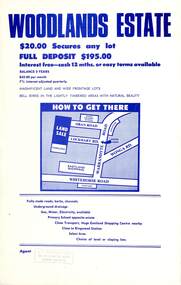 Ringwood and District Historical Society
Flyer, Land Sale Advertisement - Woodlands Estate, North Ringwood, Victoria - circa 1970
Double sided single-page advertisement for land sale with locality map and layout of Woodlands Estate subdivision in North Ringwood, with summary of local features and services. No indication of date of flyer other than post-Eastland Shopping Centre opening in 1967.Subdivision includes Oban Road, Terrigal Close, Dorelaw Drive (later Melview Drive), Naroo Court, and Barook Court. Agent's rubber stamp imprint - H.C. Walton & Son, 264 Doncaster Road, North Balwyn. -
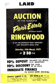 Ringwood and District Historical Society
Flyer, Land Auction Advertisement, Paris Estate, Ringwood, Vic. - 1959
Double sided single page black and yellow printed advertisement for auction of home sites at Paris Estate, Wonga Road, Ringwood, Vic., on Saturday, 14th March, 1959, with terms of sale, locality map, subdivision features and summary of local services.Subdivision includes Mullum Mullum Road, Hendra Grove, Sunhill Road, and Wonga Road. Agents in conjunction: Charles Somers & Co., South Yarra and Melbourne, and Eric Weber & Co., Melbourne and East Melbourne. -
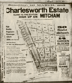 Whitehorse Historical Society Inc.
Document, Charlesworth Estate, 1913
Charlesworth Estate, Mitcham. 50 elevated allotments, 1/2 to 1 acre each and 14 garden blocks from 2 to 7 acres each. 1 March 1913.Brochure for auction of Charlesworth Estate, Mitcham. 50 elevated allotments, 1/2 to 1 acre each and 14 garden blocks from 2 to 7 acres each. 1 March 1913. Agents: Coghill & Houghton and H. Carey Sutton.Charlesworth Estate, Mitcham. 50 elevated allotments, 1/2 to 1 acre each and 14 garden blocks from 2 to 7 acres each. 1 March 1913.auctions, charlesworth estate, mitcham, quarry road, doncaster east road, burnett street, harrison street, whitehorse road -
 Whitehorse Historical Society Inc.
Document, Sale of Estate Agency, 1926
Copy of receipt for preliminary deposit of ten pounds from Mr N. Armstrong to Fred C. Drake on purchase of Estate agency business, good will and car for the sum of four hundred poundsCopy of receipt for preliminary deposit of ten pounds from Mr N. Armstrong to Fred C. Drake on purchase of Estate agency business, good will and car for the sum of four hundred pounds and copy of lodgement of remaining sums at Bank Of Victoria Ltd.Copy of receipt for preliminary deposit of ten pounds from Mr N. Armstrong to Fred C. Drake on purchase of Estate agency business, good will and car for the sum of four hundred pounds armstrong, norman, real estate agents, drake, fred c, whitehorse road, mitcham -
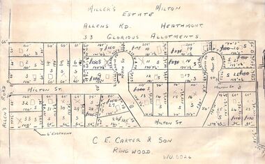 Ringwood and District Historical Society
Pamphlet - Land Sales Brochure, Miller's Estate , Heathmont - circa 1950s
Hand-drawn land subdivision map with 33 allotments of the Miller's Estate on Allens Road, Milton Street, Heath Court and Mont Court, Heathmont. Sold by CE Carter & Son, Ringwood WU6024. (2 copies, one on blue cardboard backing.)LP28038 P/R 1954 -
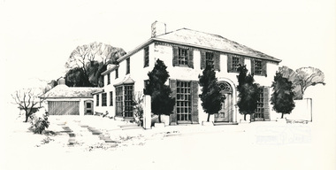 Eltham District Historical Society Inc
Photograph, Bill Caldwell, Riverhill, Rosehill Road, Lower Plenty, 1977
Sketch commissioned by Neville Emerson Real EstatePhotograph of ink sketchneville emerson real estate, lower plenty, riverhill, rosehill road, houses -
 Kew Historical Society Inc
Plan - Subdivision Plan, Summerhill Estate, 1920-1940
Pru Sanderson, in her groundbreaking ‘City of Kew Urban Conservation Study : Volume 2 - Development History’ (1988), summarised the periods of urban development and subdivisions of land in Kew. The periods that she identified included 1845-1880, 1880-1893, 1893-1921, 1921-1933, 1933-1943, and Post-War Development. These periods were selected as they represented periods of rapid growth or decline in urban development. An obvious starting point for Sanderson’s groupings involved population growth and the associated economic cycles. These cycles also highlighted urban expansion onto land that was predominantly rural, although in other cases it represented the decline and breakup of large estates. A number of the plans in the Kew Historical Society’s collection can also be found in other collections, such as those of the State Library of Victoria and the Boroondara Library Service. A number are however unique to the collection.The Kew Historical Society collection includes almost 100 subdivision plans pertaining to suburbs of the City of Melbourne. Most of these are of Kew, Kew East or Studley Park, although a smaller number are plans of Camberwell, Deepdene, Balwyn and Hawthorn. It is believed that the majority of the plans were gifted to the Society by persons connected with the real estate firm - J. R. Mathers and McMillan, 136 Cotham Road, Kew. The Plans in the collection are rarely in pristine form, being working plans on which the agent would write notes and record lots sold and the prices of these. The subdivision plans are historically significant examples of the growth of urban Melbourne from the beginning of the 20th Century up until the 1980s. A number of the plans are double-sided and often include a photograph on the reverse. A number of the latter are by noted photographers such as J.E. Barnes.The Summerhill Estate was a subdivision in Glen Iris of 24 ‘choice allotments’. The lots were primarily on both sides of Dillon Grove. Other lots at each end of the subdivision faced Margaret Street and Summerhill Road. It was from the latter that the subdivision took its advertised title. The lots were originally advertised for £10 deposit with 20 subsequent payments over five years. Pencilled on the printed plan is a change to the deposit required; a reduction to 20/-. Annotations indicate that the new deposits ranged from 30/- to 45/-. The most expensive lots faced Summerhill Road. This subdivision plan is unusual in that the front and rear of the card are for subdivisions in different localities.subdivision plans - glen iris, summerhill estate -
 Kew Historical Society Inc
Plan - Subdivision Plan, Goldthorns Hill Estate, 1925
Pru Sanderson, in her groundbreaking ‘City of Kew Urban Conservation Study : Volume 2 - Development History’ (1988), summarised the periods of urban development and subdivisions of land in Kew. The periods that she identified included 1845-1880, 1880-1893, 1893-1921, 1921-1933, 1933-1943, and Post-War Development. These periods were selected as they represented periods of rapid growth or decline in urban development. An obvious starting point for Sanderson’s groupings involved population growth and the associated economic cycles. These cycles also highlighted urban expansion onto land that was predominantly rural, although in other cases it represented the decline and breakup of large estates. A number of the plans in the Kew Historical Society’s collection can also be found in other collections, such as those of the State Library of Victoria and the Boroondara Library Service. A number are however unique to the collection.The Kew Historical Society collection includes almost 100 subdivision plans pertaining to suburbs of the City of Melbourne. Most of these are of Kew, Kew East or Studley Park, although a smaller number are plans of Camberwell, Deepdene, Balwyn and Hawthorn. It is believed that the majority of the plans were gifted to the Society by persons connected with the real estate firm - J. R. Mathers and McMillan, 136 Cotham Road, Kew. The Plans in the collection are rarely in pristine form, being working plans on which the agent would write notes and record lots sold and the prices of these. The subdivision plans are historically significant examples of the growth of urban Melbourne from the beginning of the 20th Century up until the 1980s. A number of the plans are double-sided and often include a photograph on the reverse. The Goldthorns Hill Estate subdivision was first put up for auction in 1925. The subdivision took its name from the mansion ‘Goldthorns’, shown on the plan between Normanby Road and Lady Loch’s Drive. Contemporary advertisements describe forty-three home sites being fro sale, yet only forty-one appear on this plan. Buyers were lured by the prospect of the proposed extension of the Burke Road tram to High Street. Discerning buyers were advised that only one house could be built per allotment, and that houses needed to be constructed of brick, stone or concrete and have a slate or tiled roof.goldthorns avenue -- kew east (vic.), lady loch drive -- kew east (vic.), argyle road -- kew east (vic.), lady brassey drive -- kew east (vic.), campbell street -- kew east (vic.), goldthorns -- kew (vic.), subdivisions -- kew east (viv.), goldthorns hill estate -
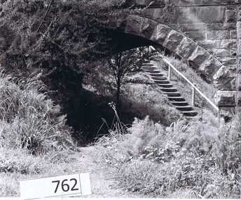 Greensborough Historical Society
Photograph Collection, Richard Pinn, Plenty River 1979, by Alan Pinn, 1979_
Photographs of the Plenty River Greensborough. One shows Richard Pinn walking his dog (Jah) on track by river, the second photo is a close up of the Greensborough Bluestone Bridge and steps to river. The bridge has since been demolished and the path replaced by a concrete bike/walking path.Shows the river pathways and bluestone bridge in the 1979.2 b&w photographs.plenty river, greensborough, richard pinn -
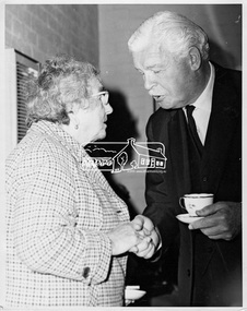 Eltham District Historical Society Inc
Photograph, His Excellency Sir Rohan Delacombe with a member during his visit to Lower Plenty Elderly Citizens' Club, 19 September 1973
The State Governor Sir Rohan Delacombe and Lady Delacombe visited the Shire of Eltham where they were entertained to a civic luncheon by the Shire President Cr. L. E. Clarke and councilors at the Panton Hill hotel and made a tour of the shire, including the Lower Plenty Elderly Citizens Centre.This photo forms part of a collection of photographs gathered by the Shire of Eltham for their centenary project book, "Pioneers and Painters: 100 years of the Shire of Eltham" by Alan Marshall (1971). The collection of over 500 images is held in partnership between Eltham District Historical Society and Yarra Plenty Regional Library (Eltham Library) and is now formally known as 'The Shire of Eltham Pioneers Photograph Collection.' It is significant in being the first community sourced collection representing the places and people of the Shire's first one hundred years.Digital imagesepp, shire of eltham pioneers photograph collection, eltham, governor of victoria, sir rohan delacombe, lower plenty elderly citizens' club, seniors, older women -
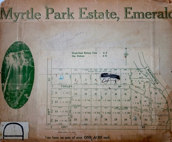 Kew Historical Society Inc
Plan - Subdivision Plan, Myrtle Park Estate, Emerald, 1915
This subdivision plan for the ‘Myrtle Park Estate’ relates to land sales in Emerald, Victoria, rather than to the subdivision of the same name in East Kew (1913-16). The subdivision in Emerald included 32 one-acre lots facing Torley Road, Government Road (now Rawhiti and Wong Hee Roads) Beaconsfield Road (now Old Beaconsfield Road). On the plan, an unnamed creek flows through allotments 8-12 on the east side of the Estate. The photograph of a waterfall and the advertised price of Day Return and Weekend Return Fares provide an indication of who the prospective purchasers were likely to be.subdivision plans - emerald, myrtle park estate, torley road -- emerald (vic.)