Showing 111968 items
matching road
-
 Ringwood and District Historical Society
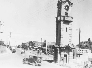
Photograph, Maroondah Highway Central, Ringwood. View looking west from Warrandyte Road- c1940's
Black and white photographImage shows clock tower at intersection of Maroondah Highway and Warrandyte Road. -
 Ringwood and District Historical Society
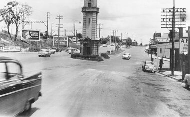
Photograph, Maroondah Highway Central, Ringwood. Clock tower at intersection of Warrandyte Road and Highway, c1960's
Black and white photograph (2 copies) Image shows Maroondah Highway looking west from Warrandyte Road. -
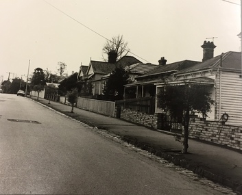
 Surrey Hills Historical Society Collection
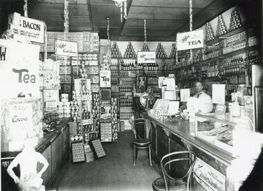
Photograph, Inside Bill Whittingham's grocery shop, 144 Union Road, 1930
Copied from a glass negative; original photo taken by Ian Barkla's father, Frank Leslie Barkla of 37 Grovedale Road. He was a keen amateur photographer and member of the Melbourne Camera Club. There is also a copy by Ken Hall. Date is approximate. The shops between Croydon and Guildford Road were built at the end of the 1920s and occupied immediately. Next north of Whitty's was H Wichell (bootmaker at 146), J T Poynton (butcher at 148), Mrs A Wardell (confectioner at 150), R J Skinner (grocer at 152), W Ives (fruit and vegetables at 154) and W R Latchford (hardware at 156). Black and white photo of the interior of Bill Whittingham's grocery shop at 144 Union Road, Surrey Hills. There is a counter on the RHS behind which there is a man in a white coat. The counter is stacked at one end with goods and at the other there is a glass case. The shelves at the rear of the shop are stacked high and there are multiple advertising signs, including ones for Perservene soap, Ovaltine, Bourn-vita cocoa and Brockhoff biscuits.Label: "I R Barkla. Collection / Location SURREY HILLS / Date ....... / Neg. No 284"whitty's, advertising, shops, grocers, businesses, union road shops, bill whittingham, frank leslie barkla -
 Wonga Park Community Cottage History Group
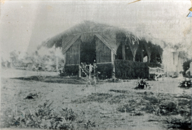
Photograph (sub-item) - The Green House on the corner of Jumping Creek Road and Hartley Road in the early 1900’s, which was used as tea rooms by Mrs. Florence Sharpe
The Green House on the corner of Jumping Creek Road and Hartley Road in the early 1900’s, which was used as tea rooms by Mrs. Florence Sharpe. -
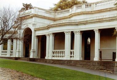 Kew Historical Society Inc
Photograph, Façade of ‘Southesk', Cotham Road, 1970
Colour enlargement of a photograph (slide) of Southesk (formerly Ordsall) in Cotham Road, Kew (demolished 1970).A colour photograph of the façade of ‘Southesk’ taken at an oblique angle. Formerly known as ‘Ordsall’, the house was built for John Halfey in 1882 on the corner of Cotham Road and Charles Street. The Italianate mansion was built in the Renaissance villa style on a bluestone plinth. Two balustrades surrounded the parapet of the roof and ran between the groups of pillars on either side of the entrance porch. The verandah was tiled and wide and Corinthian columns supported its roof. When the house passed into the hands of the City of Kew in 1948, the Council used it for a kindergarten, an elderly citizen centre and as a home for the Leo Baeck Centre. The house was demolished in 1970.david carnegie, john halfey, southesk - cotham road - kew (vic), ordsall - cotham road - kew (vic) -
 Eltham District Historical Society Inc
Photograph, Main Road, Research
Three colour photographs of Main Road between Research and Eltham East; two showing the bike path looking tworads Eltham and one viewed from Warrandyte Road near the roundabouteltham east, research, main road, research warrandyte road, warrandyte road, paths, bike paths -
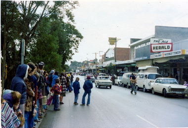 Eltham District Historical Society Inc
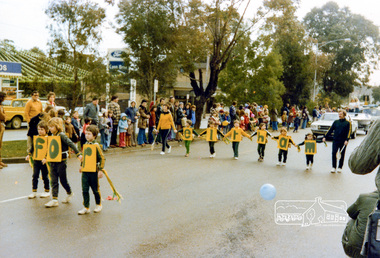
Photograph, Ruth H. Pendavingh, Eltham Festival, Main Road, Eltham
Three colour photographs near the corner of Arthur Street and Main Road; two looking diagonally across Main Road, Eltham towards Lyon Bros Ford dealership showing the general Festival parade; one looking further down Main Road from the centre median showing the newsagency and general crowd.eltham, festivals, main road, lyon bros ford -
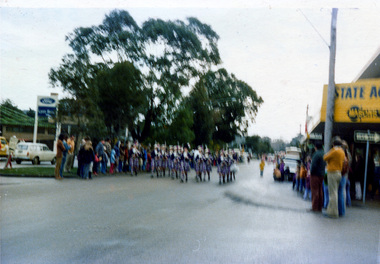 Eltham District Historical Society Inc
Photograph, Ruth H. Pendavingh, Eltham Festival, Main Road, Eltham
Three colour photographs near the corner of Arthur Street and Main Road; two looking diagonally across Main Road, Eltham towards Lyon Bros Ford dealership showing the general Festival parade; one looking further down Main Road from the centre median showing the newsagency and general crowd.eltham, festivals, main road, lyon bros ford -
 Surrey Hills Historical Society Collection
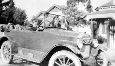
Photograph, "Overland" car in Union Road c 1927, 1927
The car has been identified as belonging to Natale and Ethel Cerini who lived at 215 Union Road. The Victorian style home in the background is their home. Ethel May Cerini is standing centre right. The girl standing up may be Jocelyn Cerini. Her sister Lynette is also in the photo. Other children are local friends and neighbours. The 'driver' is possibly Jocelyn's cousin.Black and white photo of children in a car outside houses, identified as being in Union Road. Two women stand behind the car which has the hood down and has registration number 46063. The house on the right is Victorian style with a verandah with iron lacework. The house on the left is a later style typical of the 1920s.union road, cars, houses, victorian style, natale cerini, ethel cerini, ethel swan, jocelyn cerini, jocelyn hall, lynette cerini -
 Surrey Hills Historical Society Collection
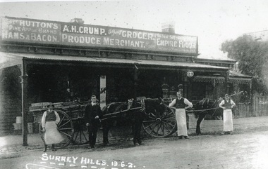
Photograph, Alfred Henry Crump's grocery and produce store in Canterbury Road, Surrey Hills, 1913, 1913
This building was adjacent to Surrey Lodge, on the corner of Canterbury and Union Roads. The store was established by George Sim in 1885 and in 1889 he set up the 1st Surrey Hills Post Office here. The business was bought by Alfred Claude Geer in 1909; the Camberwell Rate books show that from 1913 Geer remained owner but the business was occupied by Alfred Henry Crump; confirmed by electoral rolls for 1913-1918. Prior to moving to Surrey Hills, Alfred was a grocer in Dandenong. Otto Kuhn was Alfred Crump's store manager and may have taken this photo. Alfred married Hazel May Ordish in 1913 in Dandenong. The marriage notice in the Argus on 5 July indicates that the couple resided at 'Hazeldene' in Leopold Crescent. Moran and Cato had already established a business across Union Road from McNeill's Hotel and in time this business and one other grocery store opposite closed as a result.Black and white photo of A H Crump's grocery and produce store in Canterbury Road, Surrey Hills in 1913. There are 4 men and 2 horse-drawn carts in front of a timber single-storey building with a verandah with a corrugated-iron roof. At least one of the carts has "A H CRUMP" painted on the side. Three of the men are wearing long white aprons; the other, AH Crump, is in a suit. Advertising signs on the hoardings are for Huttons hams and bacon and Empire flour. Cadbury's cocoa is advertised on the shop window. The hoarding above the verandah also indicates that the business was established in 1884. There is a block-fronted single storey house with a picket fence adjacent to the shop, to the east along Canterbury Road."SURREY HILLS.13.6.2" diagonally across the bottom LH side of the photo.post offices, grocers, shops, businesses, horse drawn vehicles, alfred henry crump, alfred crump, alfred claude geer, alfred geer, otto kuhn, george sim, hazel may ordish, hazel may crump -
 Warrnambool and District Historical Society Inc.
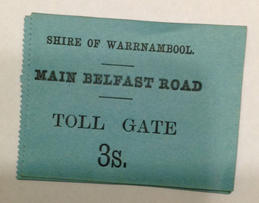
Document - Main Belfast Road Toll Gate Ticket Collection, 1860s
The Shire of Warrnambool operated toll gates from 1866 to 1869 as a means of raising revenue for road construction. There were three toll gate locations – on the main Belfast (Port Fairy) Road at Dennington Bridge, on the Woodford Road at Russells Creek and on the Geelong Road at the Allansford Bridge. The toll gates were unpopular and unprofitable for the lessees as travellers were able to avoid the tax by skirting around the gates. They had toll houses besides the tollgates. The printers of these tickets, William Fairfax and Henry Laurie, were the lessees at the time of the Warrnambool Examiner newspaper. This paper, founded by Richard Osburne and John Wilkinson, and published with some gaps from 1851 to 1880, is a key source today of Warrnambool’s history at the time. These toll gate tickets are significant because:- 1. They date back to the 1860s and were only issued from 1866 to 1869 2. They are the only artefacts we hold of the time when toll gates were operating in our local district 3. They are the best example of how the Shire of Warrnambool in its early history raised revenue for road building and maintenance. These are eleven toll gate tickets, ten for the Belfast (Port Fairy) Road toll gate and one for the Woodford Road toll gate. One is mounted on a Swintons store label (6 pence) and four are mounted on cardboard (2 shillings, sixpence, and two shillings and sixpence) and six are loose (three shillings, two shillings and sixpence and threepence). The Belfast Road tickets are yellow, green, blue and cream and the Woodford Road one is white. All have black printing. There is also an undated newspaper cutting with information on the toll gate tickets. Belfast Tickets: Shire of Warrnambool, Main Belfast Road, Toll Gate and the price Woodford Road: Shire of Warrnambool, Woodford Road, Toll Gate, 1s 6d Six of the eleven tickets also have ‘Fairfax and Laurie, Printers’ The sixpence ticket on card has the name R P Christian in ink written on the back of the card. shire of warrnambool, toll gates, r p christian, woodford road, main belfast road, swintons pty ltd -
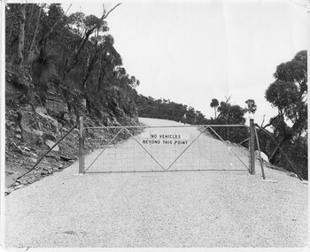 Halls Gap & Grampians Historical Society
Photograph - B/W, C 1960s (?)
A photo of the gate barring vehicle access to the top portion of the Mt William Road. The photo is part of a Ministry of Tourism campaign.The photo shows an iron gate across a road (Mt William Road). There is a man standing on the edge of the road in the background. A sign on the gate reads 'No vehicles beyond this point'.'Ministry of Tourism of Victoria, 276 Collins St., Melbourne, Nag. No.... , Date ..., Locality Grampians, Subject Gate-Mount William Road.' stamped on back.access routes, roads, scenery, mount william -
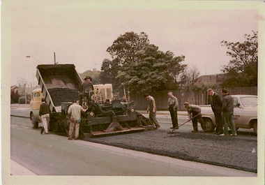 Kew Historical Society Inc
Photograph - Studley Park Road Reconstruction, 1968
One of a series of photographs donated by the City Engineer of the former City of Kew, relating to road works. The photos variably include council workers, signage and equipment.One of a series of photographs of core local government services as practised by the City of Kew. The photographs are an accurate record of street works of the period. This example is one of the few shot in colour in the 1960s. Original colour photographic positive of roadworks in Studley Park Road in the former City of Kew. A tip truck carrying bitumen unloads it contents on the road which is then levelled by a tray. Road workers supervise the road making. "STUDLEY PARK ROAD RECONSTRUCTION / 1 1/2" NOM [sic] SIZE BIT BINDER COURSE / JANUS CONSTRUCTIONS / 9TH OCT 1968"city of kew, local government -- city of kew, road works, street works, studley park road -- kew (vic.) -
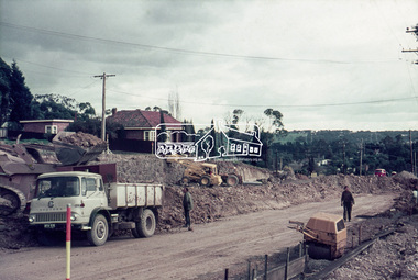 Eltham District Historical Society Inc
Slide, Looking southwest across to 184 Main Road, Lower Plenty during road widening works, 20 July 1970, 1970
Road works to widen and duplicate Main Road at Lower Plenty from top of hill near Grand Boulevard, Montmorency to shire border at Lower Plenty bridge35 mm colour positive transparency Mount - Agfacolor Service (Blue)duplication, lower plenty, main road, road construction -
 Eltham District Historical Society Inc
Slide, Looking east along Main Road, Lower Plenty near No. 184 during road widening works, 20 July 1970, 1970
Road works to widen and duplicate Main Road at Lower Plenty from top of hill near Grand Boulevard, Montmorency to shire border at Lower Plenty bridge35 mm colour positive transparency Mount - Agfacolor Service (Blue)duplication, lower plenty, main road, road construction -
 Eltham District Historical Society Inc
Slide, Looking southwest along Main Road, Lower Plenty near No. 169 during road widening works, 20 July 1970, 1970
Road works to widen and duplicate Main Road at Lower Plenty from top of hill near Grand Boulevard, Montmorency to shire border at Lower Plenty bridge35 mm colour positive transparency Mount - Agfacolor Service (Blue)duplication, lower plenty, main road, road construction -
 Eltham District Historical Society Inc
Slide, Looking southwest along Main Road, Lower Plenty near No. 167 during road widening works, 20 July 1970, 1970
Road works to widen and duplicate Main Road at Lower Plenty from top of hill near Grand Boulevard, Montmorency to shire border at Lower Plenty bridge35 mm colour positive transparency Mount - Agfacolor Service (Blue)duplication, lower plenty, main road, road construction -
 Eltham District Historical Society Inc
Slide, Looking northeast along Main Road, Lower Plenty near No. 122 during road widening works, 20 July 1970, 1970
Road works to widen and duplicate Main Road at Lower Plenty from top of hill near Grand Boulevard, Montmorency to shire border at Lower Plenty bridge35 mm colour positive transparency Mount - Agfacolor Service (Blue)duplication, lower plenty, main road, road construction -
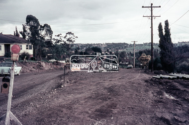
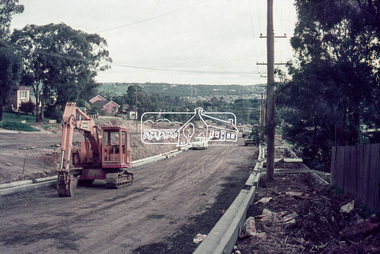
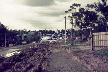
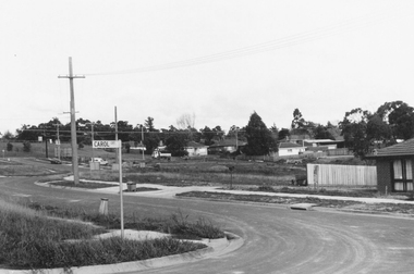 Ringwood and District Historical Society
Photograph, Westward view along Jull Road from corner of Carol Court, North Ringwood - 1981
Written on back of photograph, "E621. N3. 1981. Jull Road, North Ringwood from Carol Court looking towards Oban Road. North Ringwood sports ground centre left". -
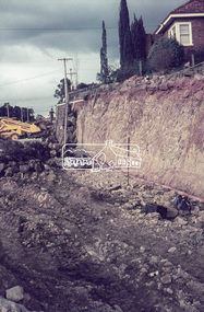
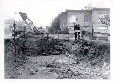 Kew Historical Society Inc
Photograph - Road works in the City of Kew, 1968-9
One of a series of photographs donated by the City Engineer of the former City of Kew, showing road works. The photos variably include council workers, signage and equipment.One of a series of photographs of core local government services as practised by the City of Kew. The photographs are an accurate record of street works of the period. Original black and white photographic positive of a road works in the former City of Kew. The photo shows an excavation in Studley Park Road near the corner of Carson Street in 1968/9. A Council officer and worker inspect the pit. Excavation equipment and a Council truck are at the back of the view. STUDLEY PARK ROAD AT CARSON STREET 1968/9city of kew, local government -- city of kew, road works, street works, kew city depot, studley park road -- kew (vic.) -
 Eltham District Historical Society Inc
Photograph, A.R. Warren's house, Main Road, Eltham
Black and photograph of A.R. Warren (Fuel Merchant) house, taken from across Main Road to front of house. Present day location of Le Pine Funerals, 848 Main Road, Eltham.a.r warren, main road, eltham, houses -
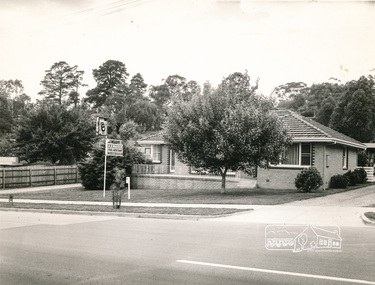
 Kew Historical Society Inc
Photograph, City of Kew, Houses, Edgevale Road, Kew, c.1980
One of a series of photos created for an exhibition by the City of Kew of notable locations. The photos represent a snapshot in time.Enlarged photograph of houses on the east side of Edgevale Road between Wellington Street and Cotham Road in Kew, mounted on board, and donated to the Kew Historical Society by the City of Kew on 10 April 1991.From Kew City C'cil 10 April 1991edgevale road - kew, city of kew -
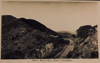 Kew Historical Society Inc
Postcard, Alpine Road Near Mount Blowhard
One of a number of 'real photo' and commercial postcards created by or owned by members of the Christian and Washfold families of Kew. The postcards are part of a larger collection of photographs, postcards and publications donated to the collection in May 2021.A 'real photo postcard', printed by Kodak Melbourne possibly from a photograph by Henry Christian, of an alpine road near Mt Feathertop. The postcard depicts a man with a bag walking along an alpine road.mt blowhard, postcards, landscape photography, christian-washfold collection -
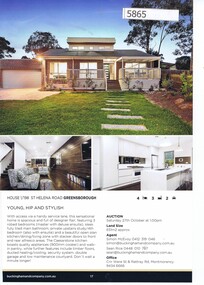 Greensborough Historical Society
Advertising Leaflet, Buckingham and Company Estate Agents, 1/198 St Helena Road Greensborough; and, 1 & 2/60 St Helena Road Greensborough, 2018_08
Advertising for 1/98 St Helena Road Greensborough, 4 bedroom house, on market March 2019 for $850,000; and, 1 & 2/60 St Helena Road Greensborough, new development, 3 or 4 bedroom homes; previous sales of 60 St Helena Road, sold June 2015 for $520,000, and December 2014 $400,000. Colour page from real estate magazine, printed both sides.st helena road greensborough -
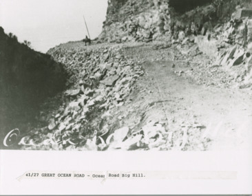 Lorne Historical Society
Photograph, Big Hill Great Ocean Road
Photograph showing man on horse at Big Hill on the Great Ocean Roadbig hill; great ocean road; -
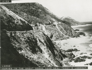 Lorne Historical Society
Photograph, Photograph West of Cumberland River on the Great Ocean Road
Photo showing the curves on the Great Ocean Road west of the Cumberland River/great ocean road: west of cumberland river; -
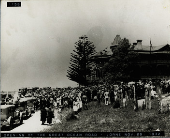 Lorne Historical Society
Photograph, Opening Great Ocean Road at Lorne 1932
At the Lorne Hotel on the opening of the Great Ocean Road on 26th November 1932g.o.r-opening; lorne hotel; 26th-november-1932 -
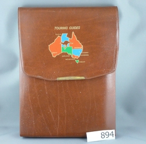 Greensborough Historical Society
Road Maps, The Herald Road Guide, 1955-1956
Contains maps of Melbourne and surrounding areas as well as routes from Melbourne to other state capitals.Contains maps and descriptions of the Melbourne area in the era before the large scale urbanisation after 1960. Also includes country and day tour maps before highways were common.Book of road maps, 271 pages, in brown plastic carry case.maps, melbourne, victoria, day tours, touring maps -
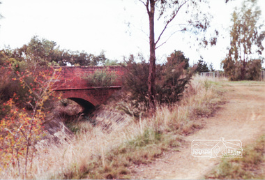 Eltham District Historical Society Inc
Photograph, Parsons Road bridge over former Maroondah Aqueduct
Colour photograph of Parsons Road bridge over disused Maroondah Aqueductparsons road, eltham north, research, aqueducts, maroondah aqueduct, bridges