Showing 23702 items
matching sardine-creek
-
 Eltham District Historical Society Inc
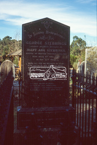
Slide - Photograph, Nillumbik Cemetery, 35 Main Street, Diamond Creek, 27 May 1990
George Stebbing arrived from England in 1857 and settled at Eltham after a short period at Kangaroo Ground. His occupation is often listed as a farmer but he built a number of important buildings between the late 1860’s and the 1880’s. Those remaining include Shillinglaw Cottage, St. Margaret’s Church, Uniting church (formerly Methodist Church) and House at 84 Pitt Street, Eltham. From 1871 to 1875 he was a member of the Eltham Shire Council. Evelyn Observer and Bourke East Record (Vic. : 1902 - 1917), Friday 12 March 1909, page 2 ELTHAM. (FROM OUR OWN CORRESPONDENT.) One of the oldest inhabitants of Eltham passed away during the early hours of Saturday last in the person of Mrs Mary Ann Stebbings. Her residence here covered a period of some-what over 50 years. She had been a widow for some time, her husband, the late Mr. Geo. Stebbings, having pre-deceased her some fourteen or fifteen years. During the later years of her life, she had resided with her niece, Mrs. Wm. Williams. She lived a very retired life and is said to have owned a considerable amount of property, local and suburban, at the time of her death, at the age of 82 years. She was interred at Diamond Creek on Sunday, 7th inst. Local Cemetery Excursion Sunday 27 May 1990 departed Eltham Shire Office at 9.30am and finish mid afternoon. Visits to Eltham , Kangaroo Ground, Queenstown (Smiths Gully), Nillumbik (Diamond Creek), St Katherines (St Helena) Hurst family graves at Hurstbridge and a little known early cemetery at Greensborough. Attended by 20 members. In each case we were introduced to the cemetery with a brief talk. At Eltham, Frank Burgoyne gave us the benefit of his knowledge as a member of the cemetery trust and at Kangaroo Ground, Bruce Ness spoke in a similar capacity. The lunch stop was at Hurstbridge where we visited the Hurst family graves. The President of Nillumbik Historical Society, Jock Ryan, joined us at the Nillumbik (Diamond Creek) cemetery. He travelled on to St Katherines, St Helena, where he talked on the history of the church and cemetery. 35mm colour positive transparency (1 of 23) Mount - Agfachrome Agfa CS System black 8 dotsshire of eltham historical society, cemetery excursion, graves, activities, cemeteries, george stebbing, george stebbings, mary ann stebbing, mary ann stebbings, nillumbik cemetery -
 Eltham District Historical Society Inc
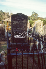
Slide - Photograph, Nillumbik Cemetery, 35 Main Street, Diamond Creek, 27 May 1990
George Stebbing arrived from England in 1857 and settled at Eltham after a short period at Kangaroo Ground. His occupation is often listed as a farmer but he built a number of important buildings between the late 1860’s and the 1880’s. Those remaining include Shillinglaw Cottage, St. Margaret’s Church, Uniting church (formerly Methodist Church) and House at 84 Pitt Street, Eltham. From 1871 to 1875 he was a member of the Eltham Shire Council. Evelyn Observer and Bourke East Record (Vic. : 1902 - 1917), Friday 12 March 1909, page 2 ELTHAM. (FROM OUR OWN CORRESPONDENT.) One of the oldest inhabitants of Eltham passed away during the early hours of Saturday last in the person of Mrs Mary Ann Stebbings. Her residence here covered a period of some-what over 50 years. She had been a widow for some time, her husband, the late Mr. Geo. Stebbings, having pre-deceased her some fourteen or fifteen years. During the later years of her life, she had resided with her niece, Mrs. Wm. Williams. She lived a very retired life and is said to have owned a considerable amount of property, local and suburban, at the time of her death, at the age of 82 years. She was interred at Diamond Creek on Sunday, 7th inst. Local Cemetery Excursion Sunday 27 May 1990 departed Eltham Shire Office at 9.30am and finish mid afternoon. Visits to Eltham , Kangaroo Ground, Queenstown (Smiths Gully), Nillumbik (Diamond Creek), St Katherines (St Helena) Hurst family graves at Hurstbridge and a little known early cemetery at Greensborough. Attended by 20 members. In each case we were introduced to the cemetery with a brief talk. At Eltham, Frank Burgoyne gave us the benefit of his knowledge as a member of the cemetery trust and at Kangaroo Ground, Bruce Ness spoke in a similar capacity. The lunch stop was at Hurstbridge where we visited the Hurst family graves. The President of Nillumbik Historical Society, Jock Ryan, joined us at the Nillumbik (Diamond Creek) cemetery. He travelled on to St Katherines, St Helena, where he talked on the history of the church and cemetery. 35mm colour positive transparency (1 of 23) Mount - Agfachrome Agfa CS System black 8 dotsshire of eltham historical society, cemetery excursion, graves, activities, cemeteries, george stebbing, george stebbings, mary ann stebbing, mary ann stebbings, nillumbik cemetery -
 Sunbury Family History and Heritage Society Inc.
Photograph
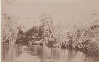
The postcard features a view of the Jacksons Creek in Sunbury. Before settlement, Jacksons Creek was the main source of water in Sunbury. It flows from the Macedon Ranges and is an important arm of the Maribyrnong River. A sepia photograph in post card format of a view of a river in the country. JACKSONS CREEK SUNBURYjacksons creek, sunbury -
 Eltham District Historical Society Inc
Photograph - Digital Photograph, Marguerite Marshall, Sutherland Home for Children, Diamond Creek, 27 September 2007
The Sutherland Homes for Children on Yan Yean Road, Diamond Creek cared for thousands of children from when it was opened in 1912. The site closed for this purpose in 1991 and was sold and later developed for commercial and office purposes. Covered under Heritage Overlay, Nillumbik Planning Scheme. Published: Nillumbik Now and Then / Marguerite Marshall 2008; photographs Alan King with Marguerite Marshall.; p107 The Sutherland Homes for Children at 14 Yan Yean Road, Diamond Creek, cared for thousands of children since they opened in 1912, after beginning at La Trobe Street, Melbourne in 1908. In 1994 Sutherland Homes (then called Sutherland Child, Youth and Family Services) amalgamated with Berry Street Child and Family Welfare. Together as Berry Street Victoria, they formed Victoria’s largest independent provider of support and accommodation services for children, young people and families in crisis.1 However with the move from institutional to community care, the Diamond Creek site had not been used since 1991 and was sold to private purchasers in 1999. More than 2000 former residents, staff, neighbours and friends attended a farewell in February, 2000.2 The Sutherland Homes red-brick and stuccoed building in Diamond Creek (a rare design in the Eltham Shire), was opened in 1929 by Lord Somers, the Governor of Victoria. Destitute children lived in dormitories bathed in natural light through large windows. However in 1958 as the cottage–parent system replaced the dormitory system, the first of eight residential cottages accommodating ten to 12 children was built. The site also included Special School 3660 and a farm, and the children were able to form relationships with people outside Sutherland, by staying with holiday hosts. Children were originally placed at Sutherland because of extreme poverty, or because single parents could not cope. However later, most placements occurred due to family violence, abuse or neglect. The property was originally bought from the Crown in 1869 by Timothy Mahony. Later owner, Augusta Meglin, ran a 40-acre (16ha) farm there. In 1909 she bequeathed this, including the house, orchards, vegetable gardens, vineyards and the balance of her income to The Sutherland Homes for Neglected Children. Sutherland Homes’ founder, Selina Sutherland, was known as ‘New Zealand’s Florence Nightingale’. In 1888 she became Victoria’s first licensed ‘child rescuer’3 and was to rescue around 3000 waifs from Victoria’s streets and slums.4 Born in Scotland in 1839, Sutherland joined her sister, who had emigrated with her husband to New Zealand. Sutherland trained as a nurse and led the establishment of a public hospital at Masterton. In 1881, while holidaying in Melbourne, Sutherland was so touched by seeing young people living under Princes Bridge, that this determined her future work. Meanwhile Sutherland instigated the Melbourne District Nursing Society, (now Royal District Nursing Service). She also led the founding of The Victorian Neglected Children’s Aid Society (now Oz Child) and the Presbyterian Neglected Children’s Aid Society (now Kildonan). From 1894 Miss Sutherland was Melbourne’s best known woman and cut a distinctive figure, wearing an alpine hat with a prominent feather. In 1906 Prime Minister Alfred Deakin named her Melbourne’s most successful philanthropic worker. However she was to face some difficult times. That year she suffered severely from an injured shoulder and dizzy turns and was pressured to resign as Superintendent of The Victorian Neglected Children’s Aid Society. In 1908 the committee of management offered her 12 months leave with pay. Sutherland declined – but soon after, was dismissed. However she continued her work from Latrobe Street, Melbourne, with the help of Sister Ellen Sanderson and several committee members. Sutherland attempted to register her new organisation but the Victorian Neglected Children’s Aid Society objected to the government, alleging that Sutherland, because of increasing infirmity, was unable to satisfactorily carry out such duties. They accused her of cruelty and of intoxication. However the charges were not proven, so The Sutherland Homes for Neglected Children was registered.5 Sadly, in 1909 Sutherland died, the day she was to move the children to the ‘country property’ at Diamond Creek. At her death she owned less than £10. Today Berry Street recognises Sutherland’s enormous contribution to child welfare with a memorial and an annual Selina Sutherland Award, presented to an outstanding volunteer.This collection of almost 130 photos about places and people within the Shire of Nillumbik, an urban and rural municipality in Melbourne's north, contributes to an understanding of the history of the Shire. Published in 2008 immediately prior to the Black Saturday bushfires of February 7, 2009, it documents sites that were impacted, and in some cases destroyed by the fires. It includes photographs taken especially for the publication, creating a unique time capsule representing the Shire in the early 21st century. It remains the most recent comprehenesive publication devoted to the Shire's history connecting local residents to the past. nillumbik now and then (marshall-king) collection, diamond creek, sutherland home for children -
 Eltham District Historical Society Inc
Photograph, Demolishing the Bini Shell at Diamond Creek, 1991, 1991
In 1978 Diamond Valley Shire recognised the need for a new public hall in Diamond Creek. Council considered the Bini shell form of construction which was in operation overseas and in use in New South Wales as libraries, gymnasiums, sports centres and multi-purpose centres. The Council gave the go-ahead. A site was chosen opposite the Hotel and close to the railway line. One day in - the following year, in 1979, activity stood still in Diamond Creek as school children and other excited spectators watched the one-hour inflation of the Bini Shell. This unusual method of construction was invented by Italian industrial designer and architect Dante Bini. The construction pneumatically raises a level of reinforced concrete from ground level which has not been set, using an internal balloon. The inner membrane inflates and compresses the mesh and concrete against the outer membrane. A net of flexible steel rods was laid on the building’s circular base, on the top of a fabric bladder. 300 tonnes of reinforced concrete were poured onto the mesh and a sealed cover laid over the concrete making a sandwich of cover, bladder and mesh. Compressed air was pumped into the bladder and the sandwich slowly began to rise and become a massive self-supporting dome. After inflation and removal of the outer membrane workmen filled in any holes. It was some days before pneumatic drills pecked out the first opening. The ceiling of the concrete dome was lined with fluffy insulating material. The dome was 36 metres in diameter at the base and 12 metres high in the centre with a usable floor space of 670 square metres. An opening night dinner was held to celebrate the new facility on March 12, 1980. Shire President Ron Pata made a speech and unveiled a plaque. It was the first public building in Victoria to be erected using the Bini Shell design method of construction The facility could cater for up to 400 people and in 1980 a fee for use was $100 for up to 200 people, $150 for up to 300 people and $200 for up to 400 people. For the next ten years or so, locals attended the hall for marital arts classes, basketball and netball games and school discoes and various other activities. After pieces of concrete fell off a Bini shell interstate due to a construction fault, the Council closed the centre. Demotion took place during the Diamond Creek Town Fair in 1991, as part of the annual Town Fair’s program. Research by L.P. Jan 2022This was the first public building in Victoria to be erected using the Bini Shell design method of construction.Colour photograph1991, diamond creek, bini shell, demolition, oval -
 Eltham District Historical Society Inc
Photograph, Fred Mitchell, Bini Shell at Diamond Creek, 1983, 1983
In 1978 Diamond Valley Shire recognised the need for a new public hall in Diamond Creek. Council considered the Bini shell form of construction which was in operation overseas and in use in New South Wales as libraries, gymnasiums, sports centres and multi-purpose centres. The Council gave the go-ahead. A site was chosen opposite the Hotel and close to the railway line. One day in - the following year, in 1979, activity stood still in Diamond Creek as school children and other excited spectators watched the one-hour inflation of the Bini Shell. This unusual method of construction was invented by Italian industrial designer and architect Dante Bini. The construction pneumatically raises a level of reinforced concrete from ground level which has not been set, using an internal balloon. The inner membrane inflates and compresses the mesh and concrete against the outer membrane. A net of flexible steel rods was laid on the building’s circular base, on the top of a fabric bladder. 300 tonnes of reinforced concrete were poured onto the mesh and a sealed cover laid over the concrete making a sandwich of cover, bladder and mesh. Compressed air was pumped into the bladder and the sandwich slowly began to rise and become a massive self-supporting dome. After inflation and removal of the outer membrane workmen filled in any holes. It was some days before pneumatic drills pecked out the first opening. The ceiling of the concrete dome was lined with fluffy insulating material. The dome was 36 metres in diameter at the base and 12 metres high in the centre with a usable floor space of 670 square metres. An opening night dinner was held to celebrate the new facility on March 12, 1980. Shire President Ron Pata made a speech and unveiled a plaque. It was the first public building in Victoria to be erected using the Bini Shell design method of construction The facility could cater for up to 400 people and in 1980 a fee for use was $100 for up to 200 people, $150 for up to 300 people and $200 for up to 400 people. For the next ten years or so, locals attended the hall for marital arts classes, basketball and netball games and school discoes and various other activities. After pieces of concrete fell off a Bini shell interstate due to a construction fault, the Council closed the centre. Demotion took place during the Diamond Creek Town Fair in 1991, as part of the annual Town Fair’s program. Research by LP January 2022This was the first public building in Victoria to be erected using the Bini Shell design method of construction.Digital copy of colour photographfred mitchell collection, 1983, bini shell, diamond creek -
![Photograph - Digital image, House St Helena and Diamond Creek Roads [Greensborough], 02/05/2013](/media/collectors/4f729f5697f83e03086015b8/items/5729bbd22162f108e8de5be2/item-media/5729bc112162f108e8de617d/item-fit-380x285.jpg) Greensborough Historical Society
Greensborough Historical SocietyPhotograph - Digital image, House St Helena and Diamond Creek Roads [Greensborough], 02/05/2013
These photographs of the house on the corner of St Helena and Diamond Creek Roads was taken in 2013 to show changes over 40 years, based on Ron Reynold's sketches in the 1973 publication 'Greensborough and Greenhills' published by Cypress Books... which states "Built on a steep hill in a bush setting in the early 1920s, for a Dr Wood, the weatherboard house now overlooks an area of activity and change. The owners, Mr and Mrs E. 'Bluey' Blackburn, remember when their 3/4 acre building block dropped to the edge of a dirt road. Today the view from the high verandah encompasses the Main Street shopping centre, new and old bridges, new roads and houses, the Plenty River, natural bush, hills and sports grounds."Digital copy of colour photograph.greensborough and greenhills, st helena road greensborough, diamond creek road greensborough, wood family, ron reynolds -
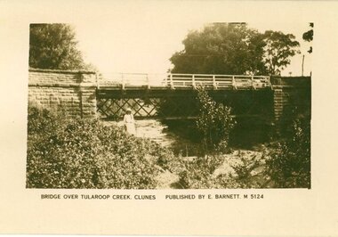 Clunes Museum
Photograph
SEPIA PHOTOGRAPH OF GOVERNMENT BRIDGE OVER TULLAROOP CREEK, CLUNES.BRIDGE OVER TULLAROOP CREEK, CLUNES. PUBLISHED BY E. BARNETT, M5124 [FOR REVERSE - SEE OVER]local history, photography, photographs, bridges -
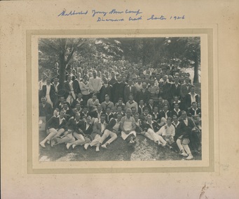 Uniting Church Archives - Synod of Victoria
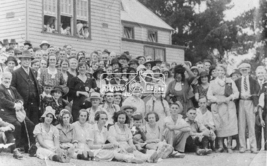
Photograph, 1926
Rev A. Vincent of Ballarat is seated at the centre of the group.B & W photograph mounted on buff card of a large group of men and boys gathered outdoors at Diamond Creek. Methodist Young Men's Camp Diamond Creek Easter 1926 -
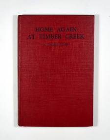 Marysville & District Historical Society
Book, Mavis Thorpe Clark, Home Again at Timber Creek, 1950
A sequel to 'The Twins at Timber Creek'. Adventures in the Australia countryside for children 7 to 11.No dust cover. Book is red with the title and the author's name in black on the front cover and spine.fictionA sequel to 'The Twins at Timber Creek'. Adventures in the Australia countryside for children 7 to 11.australia, country life, fiction, mavis thorpe clark -
 Falls Creek Historical Society
Poster - Kangaroo Hoppet 2008
The Kangaroo Hoppet is Australia’s premier long distance cross country ski race, and a member of the Worldloppet series of international cross country ski events. The first race at Falls Creek was held in 1979 under the name of “Australian Birkebeiner”. It was a 21km race with about 80 participants organised by the Birkebeiner Nordic Ski Club of Mount Beauty. The course started and finished at Falls Creek Alpine Resort and took participants out into the Bogong High Plains. After running the event for 10 years, it was decided they should become part of the Worldloppet series of marathon ski races. Representatives from the Birkebeiner Nordic Ski Club and the Australian Ski Federation attended the Worldloppet Annual Meeting in Finland in June 1990 to put the case for the acceptance of an Australian event into the Worldloppet series. Before being admitted, they had to demonstrate that the Birkebeiner Club could run a world class event, so three months later in August 1990 a 42km event named the Australian International Ski Marathon was held at Falls Creek together with a 21km Birkebeiner race and a 7km event called the Birkebeiner Lite. The event was approved by delegates from USA, Norway and Austria, in 1991 Australia became the 12th member of Worldloppet, with the condition that there had to be a name change. After some late night discussion allegedly involving red wine from North East Victoria the main event became the 42km Kangaroo Hoppet, with the minor events being the 21km Australian Birkebeiner, and 7km Joey Hoppet. In the winter of 1991, the first Kangaroo Hoppet was held. It was a great success and has been a regular fixture on the international ski calendar ever since. It features the main 42km event as well as a 21km event and a 7km event. The Hoppet brings the Australian snowfields to an international audience. In 2008 the Men's Winner was Ben Sim from Australia in a time of 1:42:16. The winner of the Women's event was Evelyn Dong of USA in a time of 2:00:35. This poster is significant because it documents an event which brings international attention to Falls Creek and the surrounding region.A poster with an image of two stylised skiers in black moving between trees towards the audience. The red sun in the background is composed by repetition of horizontal red lines of the words "KANGAROO HOPPET 18 AUGUST 30 FALLS CREEK AUSTRALIA." The logos of Falls Creek, Tourism Victoria and Worldloppet are on the bottom right hand side. text is in blue and black.At the top: AUGUST 30 FALLS CREEK AUSTRALIA 2008 KANGAROO HOPPET 18 Email: [email protected] WEB: www.hoppet.com.au PH: +61 3 57541045kangaroo hoppet, worldloppet events, falls creek, mt. beauty -
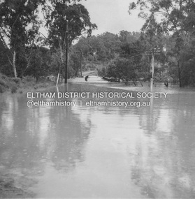 Eltham District Historical Society Inc
Album - Photograph, J.A. McDonald, Eltham-Diamond Creek Road, 21 Oct. 1953
18 October 1956 Flood level on road at corner of Railway Parade. On the immediate left out of view is Mrs Lucy Egan's home. That house still stands today nestled up against the Wattletree Road Bridge on the other side built in 1959 and is owned by the Bakos family purchased by Mrs Heather Bakos in 1960.. Prior to the Wattletree Road bridge being built, Railway Parade extended up the alignment of present-day Gastons Road to the Eltham-Diamond Creek road which ran past the entrance of the present-day carpark for Edendale Farm. This view is looking west across the Glen Park Bridge, and the beginning of Wattletree Road which sweeps around to the right in the distance. Progress Road does not exist though a road reserve is present on maps.Record of various Shire of Eltham infrastructure works undertaken during the period of 1952-1962 involving bridge and road reconstruction projects, sometimes with Eltham Shire Council Project Reference numbers quoted. It was during this period that a number of significant improvements were made to roads and new bridges constructed within the shire that remain in place as of present day (2022). In many situations, the photos provide a tangible visible record of infrastructure that existed throughout the early days of the Shire. The album was put together by or under the direction of the Shire Engineer, J.A. McDonald.infrastructure, road construction, shire of eltham, bridge construction, eltham north, floods, floodwater, glen park bridge, 1956-10-18, diamond creek (creek), eltham, railway parade, wattletree road, wattletree road bridge, gastons road -
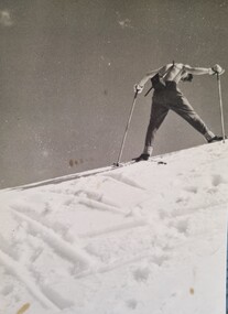 Falls Creek Historical Society
Photograph - Frank May at Falls Creek 1951
Frank May gained employment with the SEC on 1st July 1950 and was initially placed at Mount Beauty as a clerk. In September 1950 he transferred to a similar position at the Rocky Valley Dam construction site. He worked from October to April at Rocky Valley but then moved to Bogong Village as the construction site was closed during the winter. In October 1951 he returned to Rocky Valley but in November 1951 government funding cutbacks forced the SEC to he and many others from the Kiewa Hydro-Electricity Scheme were transferred or retrenched. Frank was transferred to the SEC in Colac where he worked as a meter reader. During his time at Falls Creek, Frank was a member of the Bogong Ski Club and enjoyed many adventures skiing on the High Plains.These images are significant as they depict an early SEC working skiing at Falls Creek.Two black and white images of Frank Mayfrank may, sec falls creek, bogong ski club -
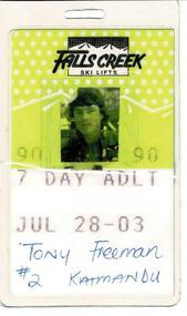 Falls Creek Historical Society
Ski Lift Passes 1990
SKI TICKETS Before tows and lifts were introduced at Falls Creek, it could take skiers 20 minutes to climb to the Summit … but only TWO minutes to go back to the bottom. The arrival of tows, then chairlifts and T-bars changed the face of skiing forever. The first rope tow was constructed by Toni St. Elmo for the 1951 winter season. Bob Hymans installed a smaller tow for his guests at Skyline Lodge. Tows were still quite slow, so in 1956 Bob Hymans created his single chairlift. In 1958 the Village rope tow, designed by Albury engineer Jock Wilson, opened. It was financed by shareholders including Bill Griffith (Bowna Ski Club) and the Bridgford family (St. Trinian’s Ski Club). Several other tows followed including the Summit T-bar in 1961, built by Ron McCallum and operated by Alpine Developments Pty. Ltd. which was a company formed by C. H. (Bill) Bridgford. By 1982 Falls Creek was served by 16 different lifts or T-bars, all owned and operated by Alpine Developments (Holdings) Pty. Ltd. During the development of Falls Creek, different methods have been used to pay for the use of tows, lifts and T-bars … including metal tokens, single tickets, strips of tickets and season passes. The Falls Creek Historical Society Collection includes many examples of these items.These tickets are significant because they represent a stage in the progression of chair lifts and management at Falls Creek Tourist Village.A selection of unused Falls Creek Ski Lift passes and one 7 Day Adult Pass issued to Tony Freeman # s Kathmandu. Different coloured tickets were for a different length of visit. A 7 Day Adult pass cost $234.On completed pass FALLS CREEK SKI LIFTS 90 7 DAY ADULT JUL 28 - 03 TONY FREEMAN #2 KATHMANDUchairlift falls creek, falls creek passes -
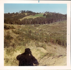 Southern Sherbrooke Historical Society Inc.
Photograph - Cardinia Creek area, Narre Warren East, prior to dam works
A set of four colour photos showing the area around where Cardinia Reservoir is now located. The photos show various views of the hillsides and valleys prior to the damming of Cardinia Creek. Each photo has 'Belgrave Cardinia Creek' handwritten on the back. They date from prior to May 1970. The set was donated to the society by David Howe. 'Belgrave Cardinia Creek' handwritten on the back of each photo. -
 Ringwood and District Historical Society
Photograph, Mullum Mullum Creek, fenced garden of a Munro St property that has encroached into the creek boundary 29th October 1989, 1989
Digital photograph -
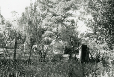
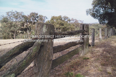 Eltham District Historical Society Inc
Photograph, Fay Bridge, Looking north towards Diamond Creek from the high point of Allendale Road, Diamond Creek, n.d
Situated opposite the driveway of 170 Allendale Road, Research, just east of where the Maroondah Aqueduct Trail crosses the roadfay bridge collection, allendale road, diamond creek, fences, research (vic.) -
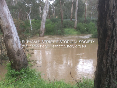 Eltham District Historical Society Inc
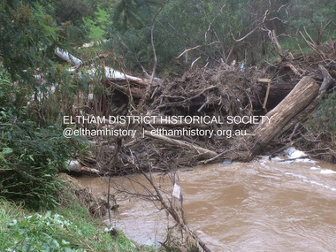
Photograph - Digital Photograph, Carlota Quinlan, Diamond Creek in flood, Diamond Creek Trail, Eltham South, 16 Oct 2021
diamond creek (creek), diamond creek trail, eltham south, flooding, floods, floodwater -
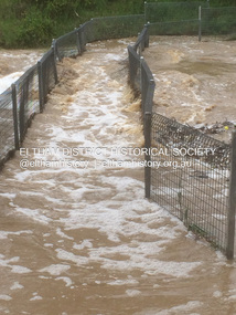
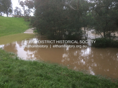 Eltham District Historical Society Inc
Photograph - Digital Photograph, Carlota Quinlan, Diamond Creek in flood, Diamond Creek Trail, Eltham South, 16 Oct 2021
diamond creek (creek), diamond creek trail, eltham south, flooding, floods, floodwater -
 Eltham District Historical Society Inc
Photograph - Digital Photograph, Carlota Quinlan, Diamond Creek in flood, Diamond Creek Trail, Eltham South, 16 Oct 2021
diamond creek (creek), diamond creek trail, eltham south, flooding, floods, floodwater -
 Eltham District Historical Society Inc
Film - Video (Digital), Carlota Quinlan, Diamond Creek in flood, Diamond Creek Trail, Eltham South, 16 Oct 2021
diamond creek (creek), diamond creek trail, eltham south, flooding, floods, floodwater -
 Eltham District Historical Society Inc
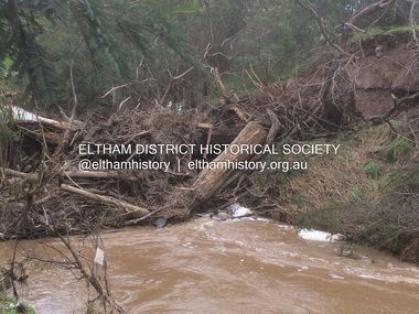
Photograph - Digital Photograph, Carlota Quinlan, Diamond Creek in flood, Diamond Creek Trail, Eltham South, 17 Oct 2021
diamond creek (creek), diamond creek trail, eltham south, flooding, floods, floodwater -
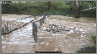
 Eltham District Historical Society Inc
Photograph - Digital Photograph, Carlota Quinlan, Diamond Creek in flood, Diamond Creek Trail, Eltham South, 17 Oct 2021
diamond creek (creek), diamond creek trail, eltham south, flooding, floods, floodwater -
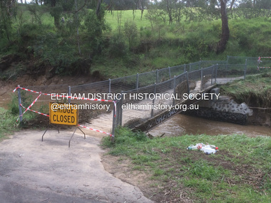
 Eltham District Historical Society Inc
Photograph - Digital Photograph, Carlota Quinlan, Diamond Creek in flood, Diamond Creek Trail, Eltham South, 17 Oct 2021
diamond creek (creek), diamond creek trail, eltham south, flooding, floods, floodwater -
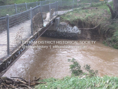
 Eltham District Historical Society Inc
Photograph - Digital Photograph, Carlota Quinlan, Diamond Creek in flood, Diamond Creek Trail, Eltham South, 17 Oct 2021
diamond creek (creek), diamond creek trail, eltham south, flooding, floods, floodwater -
 Eltham District Historical Society Inc
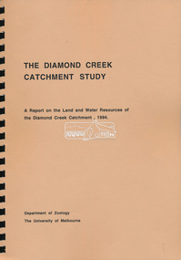
Book, Department of Zoology, The University of Melbourne, The Diamond Creek Catchment Study: A report on the Land and Water Resources of the Diamond Creek Catchment, 1994
Shire of Nillumbik -
 Eltham District Historical Society Inc
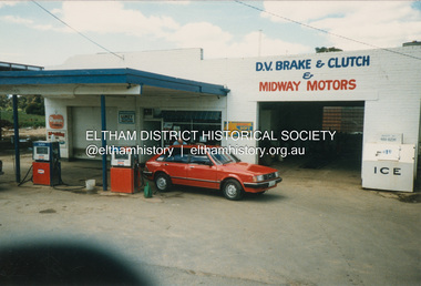
Photograph, Graeme Hardiman, D.V. Brake & Clutch & Midway Motors, 274 Diamond Creek Rd, Diamond Creek, n.d
Now a BP Service Station opposite McLaughlans Lane, Plentyd.v. brake & clutch & midway motors, diamond creek, diamond creek rd -
 Eltham District Historical Society Inc
Photograph, Gathering at Upper Diamond Creek State School No. 2059, corner of Yates and Heidelberg Kinglake Roads, Upper Diamond Creek
Black and white copy of photo printed on glossy photographic paper 30.5 x 40.5 cm (12 x 16 inch); image size approx. 18.5 x 28 cmgroups, upper diamond creek state school -
 Eltham District Historical Society Inc
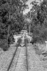
Photograph, George Coop, Derailment guard rails on the Hurstbridge line as the track crosses the Diamond Creek just north of Allendale Road, Diamond Creek, 6 December 1980, 1980
The device pictured is intended to prevent severe derailment and to keep errant trains in line with track when going over culverts or similar should they become derailedDigital TIFF file Scan of 35mm Ilford FP4 black and white transparencyallendale road, derailment guard rail, diamond creek, railway bridge -
 Eltham District Historical Society Inc
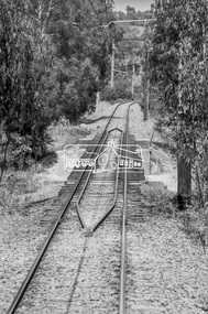
Photograph, George Coop, Derailment guard rails on the Hurstbridge line as the track crosses the Diamond Creek just north of Allendale Road, Diamond Creek, 6 December 1980, 1980
The device pictured is intended to prevent severe derailment and to keep errant trains in line with track when going over culverts or similar should they become derailedDigital TIFF file Scan of 35mm Ilford FP4 black and white transparencyallendale road, derailment guard rail, diamond creek, railway bridge