Showing 1537 items
matching verandah
-
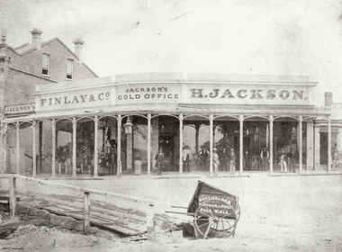 Bendigo Historical Society Inc.
Photograph - JACKSON'S GOLD OFFICE, VIEW POINT, BENDIGO - 1861?, 1860's ?
black and white ( copy ) H. Jackson's Gold Office, View Point, Bendigo. Men standing otuside office under verandah. Batchelder, Photographer, Pall Mall. Also Finlay & Co. See also Mosaic items 2400.160 and 2400.101. All details in Mike Butcher and Yolande Collis's book, An American on the Goldfields : the Bendigo Photographs of Benjamin Pierce Batchelder.' Also details of Henry Jackson's store in Bendigo Historic Buildings by Mike Butcher and Gill Flanders. National Trust of Australia (Vic). Central Victorian Branch. 1987. See Research Field for further information.Batchelder, Photographer, Pall Mallorganization, business, h. jackson's gold office, jackson, henry. finlay & co. view point, bendigo. jackson's corner. jackson's gold office. -
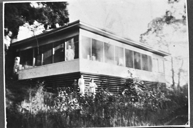 Southern Sherbrooke Historical Society Inc.
Photograph - Smith family holiday house on Park Drive, Belgrave, c.1940s
Black and white photo of the Smith family house on Park Drive just past Belgrave Lake Park. The House appears to have an enclosed verandah. A man, possibly Oscar Smith, is looking out of the window and a second person, possibly Pam Harris's sister, is also looking out. Below them, two young people, a boy and a smaller girl, are standing in the garden. This was possibly the caretaker's place. '1627' is stamped on the back of the photo. The photo probably dates to the 1940s and is part of a collection of family photos donated by Pam Harris, Shire of Sherbrooke President, 1982-1983 & 1987-1988. -
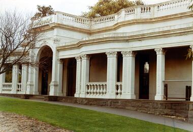 Kew Historical Society Inc
Photograph, Façade of ‘Southesk', Cotham Road, 1970
Colour enlargement of a photograph (slide) of Southesk (formerly Ordsall) in Cotham Road, Kew (demolished 1970).A colour photograph of the façade of ‘Southesk’ taken at an oblique angle. Formerly known as ‘Ordsall’, the house was built for John Halfey in 1882 on the corner of Cotham Road and Charles Street. The Italianate mansion was built in the Renaissance villa style on a bluestone plinth. Two balustrades surrounded the parapet of the roof and ran between the groups of pillars on either side of the entrance porch. The verandah was tiled and wide and Corinthian columns supported its roof. When the house passed into the hands of the City of Kew in 1948, the Council used it for a kindergarten, an elderly citizen centre and as a home for the Leo Baeck Centre. The house was demolished in 1970.david carnegie, john halfey, southesk - cotham road - kew (vic), ordsall - cotham road - kew (vic) -
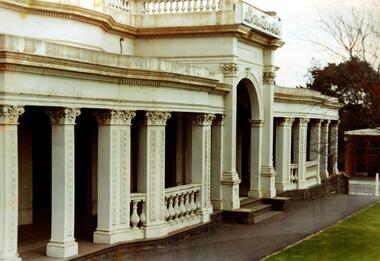 Kew Historical Society Inc
Photograph - Façade of ‘Southesk', Cotham Road, Stewart West, 1970
Colour enlargement of a photograph (slide) of Southesk (formerly Ordsall) in Cotham Road, Kew (demolished 1970).A colour photograph of the façade of ‘Southesk’ taken at an oblique angle. Formerly known as ‘Ordsall’, the house was built for John Halfey in 1882 on the corner of Cotham Road and Charles Street. The Italianate mansion was built in the Renaissance villa style on a bluestone plinth. Two balustrades surrounded the parapet of the roof and ran between the groups of pillars on either side of the entrance porch. The verandah was tiled and wide and Corinthian columns supported its roof. When the house passed into the hands of the City of Kew in 1948, the Council used it for a kindergarten, an elderly citizen centre and as a home for the Leo Baeck Centre. The house was demolished in 1970.david carnegie, john halfey, southesk - cotham road - kew (vic), ordsall - cotham road - kew (vic) -
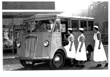 Queen Victoria Women's Centre
Postcard Series, c.2004
All photos used courtesy of Southern Health Monash Medical Centre Historical Collection. 10 postcards. Black and white photographs. standard A6 size. Woman Pathologist, 1890s to early 1900s Queen Victoria Hospital at the corner of Lonsdale and Swanston Streets 1950's Multicultural Nurses 'Give Generously' Infants in the Queen Vic Hospital maternity ward A Van donated by auxiliaries, used to transport nurses and deliver supplies to nursing homes. Around 1957. Queen Vic nurses in the 1900s Nurses in a recovery room, 1960s Matron with a blind patient and her guide dog in 1963 Queen Victoria Memorial Hospital (Mint Place) ward on a verandah 1920shosptial, postcards, historic site, charitable organisations -
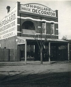 Surrey Hills Historical Society Collection
Photograph, Shop of J H Pollard, House Decorator, at 139 Union Road, Surrey Hills, 1930
This site was later occupied by Mitton's pharmacy. James Henry Pollard appears on the 1903 electoral roll as a painter in Canterbury Road (in one of the buildings that made up Hansen's Terrace.)The Union Road shops are covered by a City of Boroondara Heritage Overlay. This particular shop has changed very little with some alteration to the upper storey when it was repurposed for residential dwelling.Black and white photo of James Henry Pollard's shop at 139 Union Road, Surrey Hills in 1930. It is a 2 storey brick building with 2 glass display windows either side of the door and a corrugated iron roofed verandah supported on 3 posts. Above is a dwelling with 2 sash windows and an interior balcony within an arch. A wooden paling fence adjoins on the left. The side of the building and the front pediment carry advertising for the business. From this it appears that James Henry Pollard was an insurance agent for Guardian Assurance Company as well as being a house painter and decorator. There is a deciduous tree in the front of the shop.businesses, shops, mitton's pharmacy, guardian assurance company, union road shops, james henry pollard, painter, decorator -
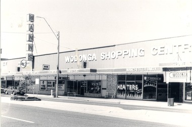 Wodonga & District Historical Society Inc
Photograph - Codling Collection 01 - High Street East - Mann's Wodonga Shopping Centre and Bob Baily SSW Supermarket, 1980s
Miss Olive Codling was a Foundation Member and a Life Member of the Wodonga Historical Society. Many of her prize-winning photos are held in the Society Collection. She also held a range of roles and committee positions in a wide range of Wodonga community organisations. These included the Horticultural Society, the Wodonga Arts Council, the Wodonga Camera Club and the Wodonga Lapidary Club. This photo collection is significant as it documents how the businesses and buildings in Wodonga have evolved and contributed to community throughout the 20th century.J. Mann and Sons was first established as a farm produce store in 1921. The range of products was extended in the 1930s and included groceries and hardware, as well as the first petrol bowser in Wodonga outside the store. After WWII, the premises were extended and the range of products continued to increase. In the 1960s the Mann Family opened a new supermarket in Wodonga, in addition to the hardware business, providing steel, plumbing and industrial supplies, and employed over 100 people. This site has since been redeveloped and is now the Mann Centre. Signs on the edge of the verandah advertise Garden Centre, Rural & Building Supplies, Footwear and a Hairstylistwodonga businesses, high st wodonga, mann wodonga -
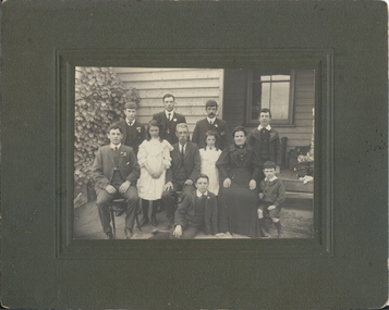 Bendigo Historical Society Inc.
Photograph - FAMILY PORTRAIT, approx. 1910
BHS Collectionblack and white photo: family. One mature female in dark gown with brooch and necklace, one mature male in suit, white shirt, tie and tie pin. One male child suited, short trrousers. Six young males suited and buttonholed, one with watch chain. Two young females, long dark curls, pinafore gown, brooch visible at throat of R. hand gown. Weatherboard house at rear, ivy at left hand border. Step and verandah visible behind group with an upholstered chair, personal belongings nearby and below four pane glazed window.2000 - 180-01 on back of photoperson, group -
 Surrey Hills Historical Society Collection
Postcard - Union Road, Surrey Hills looking north
Surrey Family Hotel (McNeill's Family Hotel) was built in 1888 by Alexander McNeill. It closed as a hotel after the Local Option vote in 1920.A colour post card from a watercolour sketch of the intersection of Union and Canterbury Roads looking north towards Mont Albert Road. It shows bluestone guttering edging the road in the foreground. Children are gathered under the verandah on the SW corner of the intersection and on the road. A horse drawn vehicle is seen travelling to the west down Canterbury Road. McNeill's Family Hotel, the Surrey Hall and part of Hansen's Terrace can be seen. Advertising signs for Otto Preuss (undertaker) and A R B Cuest (baker) can be partly seen. In the distance scattered houses and open space can be seen.Front: Printed on the post card "Union Rd. Surrey Hills, looking North" Rear: "BOX HILL HISTORICAL SOCIETY" (stamp) and "Mrs E W Zerbe / Williamson Rd. / Doncaster" in biro. This is possibly Marjorie Morgan's writing. "POST WTP (within cartouche) CARD" and "Printed / in / Germany" printed on card.mcneill's family hotel, bakers, undertakers, surrey hall, surrey theatre, rex theatre, mr a r b cuest, mr otto preuss -
 Wodonga & District Historical Society Inc
Domestic object - Meat Safe known as a "Coolgardie Safe", Early 1900s
The Coolgardie safe was invented in the late 1890s on the Western Australian goldfields. Its invention was credited to a local contractor named Arthur Patrick McCormick. It was a practical system to preserve food prior to modern refrigeration. The wire grid kept the food safe from vermin and allowed breeze to blow through. It was often covered with wet hessian so that as the breeze circulated the water evaporated, creating the same concept as coolant in modern refrigerators and ice boxes. In most respects it was a variation of the bushman’s hessian bag hanging in a tree. In larger towns and cities during this time period large "ice works" could deliver block ice to areas that required a form of refrigeration. These ice blocks where held in early refrigerators to keep perishables cool. In isolated or rural households, the Coolgardie or meat safe was the next best, practical solution for food preservation. This safe was used in the home of the Conway family in Wodonga.This item is very significant to the Wodonga region as it represents the initiative and problem solving skills of the early settlers. It also reflects the primitive conditions in which they lived before the arrival of more modern services such as electricity.Meat safe or Coolgardie safe manufactured in Australia. This safe is made from metal and has been painted in green paint. 2 sides of the safe have a pattern of 6 squares of holes to allow for ventilation and air flow. The holes would also guard against insects and other vermin. There is one shelf inside, dividing it into 2 sections. The safe has a hook attached so that it can be suspended, often from a tree or on a verandah to increase air flow. The safe would often be covered by wet hessian to promote further cooling and preservation of foods such as milk, butter and meat.coolgardie safe, food preservation, pioneers innovation -
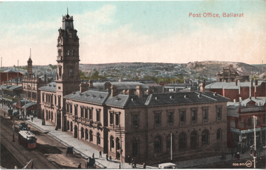 Ballarat Tramway Museum
Postcard, Post Office Ballarat, c1910
Coloured image of the intersection of Sturt and Lydiard Streets looking north along Lydiard St. North giving a high view of the Post Office building with its tower. Has an ESCo tram southbound in Lydiard St North, a motor car and several horse-drawn vehicles. Shows the verandahs along Lydiard St, centre poles, and looks towards a rather desolate Black Hill following extensive mining works. The Post Office time ball is in the down position. Possibly c1910. Summerscales building - photographer, postcards is next door to the Post Office in Sturt St. On the rear is a handwritten note from Wal Jack to Ken Magor about the tram in the photo, the time ball on the post office flagstaff, Railway station tower to the left of the Post Office, carriage sheds in the long building behind the oval type roof of old mining exchange. See item 8411 for a coloured version. Yields information about the intersection of Sturt and Lydiard Streets in the early ESCo era and the Post Office building.Postcard - black and white- divided back, undated - Valentine & Sons, Printed in Great Britain. Card Number "20-2"Notes by Wal Jack on the rear - see image 2nd image.sturt street, post office, ballarat, tramways, lydiard st, esco, black hill -
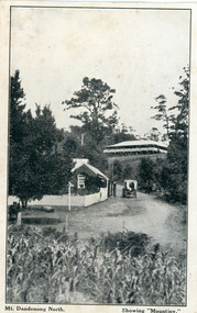 Mt Dandenong & District Historical Society Inc.
Photograph, Mt Dandenong North. Showing "Mountjoy"
The building with the white picket fence is the Beulah Tea Gardens opened by Eliza Hand c1904 at The Gap (now FiveWays). The building is still operating as a cafe. The Tourist Road does not yet exist. Old Coach Road comes into the picture from the right and the horse and cart is heading up Ridge Road. The elm trees can be seen on the left. The building up on the hill is the Mountjoy Guest House. ‘Mountjoy’ was built by the Paynter family in 1905. It had fourteen bedrooms, a dining room and sitting room, kitchen with a big wood burning range and verandahs on three sides. There were commanding views of the eastern ranges and the city to the west. Ellis Jeeves purchased ‘Mountjoy’ in 1908 and it soon became a popular tourist destination, the coach yards making it a centre of the district. ‘Mountjoy’ is a central feature of many photographs of Kalorama in the 1900s. The building burned down in 1975. Mt. Dandenong North was renamed Kalorama in 1926.Black and white postcard showing a horse and cart on road between two buildings.On front ; Mt. Dandenong North. Showing "Mountjoy."postcard, mountjoy, guest house, beulah tea room, beulah, mt dandenong north, kalorama -
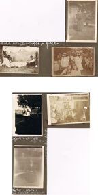 Bendigo Historical Society Inc.
Photograph - HILDA HILL COLLECTION: BLACK AND WHITE PHOTOS, 1917-1924
Series of Black & White Photos Total 6 Hill Family & Friends During the First World War and after. Rita, wearing a dark dress with white collar and holding a dark coloured hat, background is large brick structure with windows to right and small section of veranda, pal tree, Railway Reserve Kyneton 1918. Man and two women wearing white dresses and dark hats, man wears dark suit white shirt and dark tie with his back against a large wheel, white sheet on ground between them and indistinguishable articles on sheet, Hibernian Picnic Axedale November 13th 1918. Group of young girls and boys all dressed in light coloured clothing gathering Botanical gardens January 1917, Miss N. Linnane reclining on cane lounge chair on verandah, weatherboard wall of house, verandah post, rock garden edging in foreground, May 1918. Monte Video Property Queensland Jeff, dressed in dark trousers and white shirt, holding a skinned rabbit, water tank in background, wire fence, July 1924. Father & Mother, Father wears a grey suit with white shirt and dark tie, Mother seated is wearing a dark dress with striped collar and white blouse, 'The Ranche' Mollison Street Eppalock.Hilda Hill Personal Collectionaustralia, history, post war life -
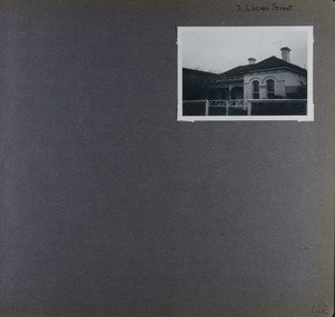 Glen Eira Historical Society
Album - Album page, Lucan Street, 7, Circa 1972
This photograph is part of the Caulfield Historical Album 1972. This album was created in approximately 1972 as part of a project by the Caulfield Historical Society to assist in identifying buildings worthy of preservation. The album is related to a Survey the Caulfield Historical Society developed in collaboration with the National Trust of Australia (Victoria) and Caulfield City Council to identify historic buildings within the City of Caulfield that warranted the protection of a National Trust Classification. Principal photographer thought to be Trevor Hart, member of Caulfield Historical Society. Most photographs were taken between 1966-1972 with a small number of photographs being older and from unknown sources. All photographs are black and white except where stated, with 386 photographs over 198 pages. Page 122 of Photograph Album with one landscape photograph of a house at 7 Lucan Street.Handwritten: 7 Lucan Street [top right] / 122 [bottom right]trevor hart, caulfield north, villa residence, verandah, terraces, timber roof brackets, gables, cast iron ridging, ornate plasterwork, arched windows, curved windows, chimneys, lucan street, victorian style, cast iron work, houses -
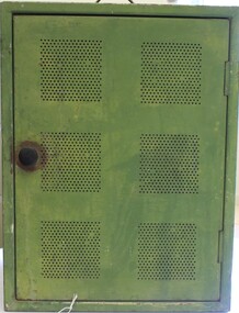
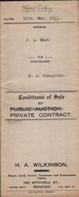 Bendigo Historical Society Inc.
Document - H.A. & S.R. WILKINSON COLLECTION: CONTRACT OF SALE
conditions of sale by private contract dated 15th May, 1933 between J.A. Nash (seller) and F.A. Stacpoole (buyer) for piece of land situate No.133 Sternberg Street,, and Skene Street, Bendigo being allotment 9 and 3 section 39C described in certificate of title volume 1361 folio 272162 and certificate of title volume 3263 folio 652414, together with 10-roomed brick and weatherboard dwelling and shop with street verandah, also gas stove, copper, troughs and bath. Also the complete stock and plant and goodwill of the vendor's butchering business carried on from above shop and premises. Price 1,150 pounds.organization, business, h.a. & s.r wilkinson real estate -
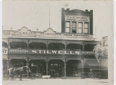 Bendigo Historical Society Inc.
Photograph - STILWELL'S HARDWARE, HARGREAVES STREET, c.1912
Black and white photograph. Stilwell's Hardware and Furniture Store, Hargreaves Street. Two story building with verandahs, iron lace. Third storey on portion of building. This storey of a different style. Horse and vehicles at front. Bath, horse trough at CF. Inscriptions: on front - 'GP16' on top RHC and top LHC. On back - 'Bendigo Historical Society (Inc)' written in ink top RHC. About 1912? - left upper park of back. Circular stamp 'Royal Historical Society of Victoria, Bendigo Branch'. In image 'F&E Stilwell, Furniture Warehouse', 'Stilwell's Ironmongers House Furnishers', 'Hardware Stilwell's Furniture'buildings, commercial, f. & e. stilwell ironmongers -
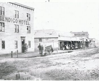 Bendigo Historical Society Inc.
Photograph - BRIDGE STREET: SANDHURST, 1861
Copy of black and white photo: Bridge Street streetscape near site of the present Chinese Museum. Showing Bendigo Hotel at left,. 'Crossingham & Goodman, Saddlers ' ' J. Holdsworth', 'Glass and Chines Warehouse'. 'Batchelder, Photographer, Pall Mall' handcart in foreground. 3 storey weatherboard building with 3 males at door, 2 males and photographers cart in front of fence. Row of single storey buildings with verandahs, some with business signs. 2 storey building at back. Deep gutters with foot bridges over. On back in grey lead '12' Note: Batchelder and his assistant are standing at the hardcart' ( James Lerk 22.9.2000 }Batchelder, Pall Mallplace, streetscape, bridge street -
 Kew Historical Society Inc
Photograph - Cottage, probably East Kew, A. Aberline, 1920s
The Kew Historical Society's map collection includes a substantial number of real estate subdivision plans, mainly of Kew but also of surrounding suburbs in Melbourne. Most of the subdivision plans date from the 1920s and 1930s when the districts old homes and local farmland were being split up to accommodate residential growth in the postwar period. These early plans were assembled by a local firm, Jas R Mather & McMillan, which had an office in Cotham Road. Many of the plans, and sometimes photos, were annotated by the agents.Subdivision plans are historically important documents used as evidence for the growth of suburbs in Australia. They frequently provide information about when the land was sold as well as evidence relating to surveyors and real estate and financial agents. The numerous subdivision plans in the Kew Historical Society's collection represent working documents, ranging from the initial sketches made in planning a subdivision to printed plans on which auctioneers or agents listed the prices for which individual lots were sold. In a number of cases, the reverse of a subdivision plan in the collection includes a photograph of a house that was also for sale by the agent. These photographs provide significant heritage information relating house design and decoration, fencing and household gardens.The photograph may also be aesthetically significant depending on the importance of the photographic atelier.An elevated, modest weatherboard house, photographed towards the end of the construction phase. The lower section of the weatherboards are exposed and stained. The upper section is rendered with rough-cast. The tiled roof has a single gable that extends over the centrally placed front porch. On the porch, the door and single sidelight are filled with coloured leadlight whereas the casement windows in the front rooms contain plain glass. The leadlight and the wrought iron of the verandah are the only decorative elements of the utilitarian design. The location of the house, which was advertised for sale, has not to date been identified. The real estate photograph is mounted on the reverse of a subdivision plan for the Harvest Home Estate, Kew East.Photographer's stamp, lower right on mount: "A. Aberline, Glenferrie"houses - kew, bungalows - kew, real estate photographs -
 Stawell Historical Society Inc
Photograph, Houses in Houston Street -- 4 Photos
Houston St. & Houses. Series of 4 photosFour Colour Photgraphs 225 of a brick building with a palm tree in front. a white car in the front on the left. 38 Houston Street 225a - white brick house with arched verandah, and tiled roof. M.T. White 42Houston Street. 225b - Withe Wetherboard miners cottage, wiith red corregated roof. next to a similar building with faded grey? roof. 225c a view of houston street lloking westtoward the Grampians 225d - A house light brow in colour with two chimneys and an upper window with shutters, low brick fence topped with arched iron railings gateway covered with an archway with tiled topstawell houses -
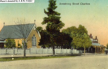 Charlton Golden Grains Museum Inc
Photograph, St Martin's Anglican Church, Armstrong St Charlton
St Martin's Anglican Church was built in 1889. Victoria Hall was built for E. Miles in 1884. The post card is part of a series taken c. 1907.Copy of a coloured (hand coloured?) post card showing St Martin's Anglican Church, Armstrong St, Charlton. The church is a yellow, timber building with a cross at each end of the roof. A white picket fence runs along the front of the church. There are three trees on the edge of the road in front of the church. There is a large single storey red brick building to the right of the church with a verandah over the footpath. A horse is coming down the road past the red brick building. The post card has Armstrong Street Charlton in the top right. There is a typed note in the top LH corner of the photo that says Photo's donated by J. & K. Cossar.pastoral care, st martin's, angllican, church, armstrong street, charlton -
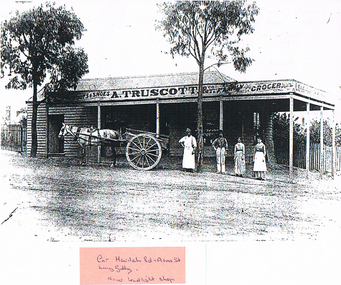 Bendigo Historical Society Inc.
Photograph - LONG GULLY HISTORY GROUP COLLECTION: A TRUSCOTT & CO
A. Truscott took over this drapery and grocery store from Mr Pengally upon his retirement in November 1884Copy of a black and white photo of A. Truscott & Co., Family Grocer, Long Gully. Weather board building with a veranda. Two gum trees in front of the shop. A grey horse is harnessed to a dray and there are two men and two women behind it. A pink sticker is stuck on the bottom with - Cnr havilah Rd , Arms St. Long Gully. Now Leadlight Shop - written on it. Written on the back is: Verandah blown off by whirly wind Landed on top of shop roof. Now replaced 1986. Cnr Havilah Rd & Arms St. This photo also has references in Box 704, Truscott collection, 12322 - 12324.bendigo, history, long gully history group, the long gully history group - a truscott & co, leadlight shop -
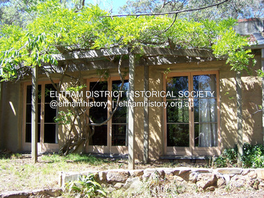 Eltham District Historical Society Inc
Photograph - Digital Photograph, Marguerite Marshall, Former home of Professor William MacMahon Ball, York Street, Eltham, 24 May 2007
Situated at the eastern end of York Street, Eltham, 'Shinrone', the former home of Professor William (Mac) MacMahon Ball was one of the first in the Shire of Eltham to incorporate mud-brick. Professor MacMahon Ball, a political scientist, writer, broadcaster and diplomat and family moved to York Street, Eltham in 1945 into a timber cottage built around the 1890s and in poor repair. Mac asked Alistair Knox to renovate the home and he expanded the living area and added verandahs. In 1948 Montsalvat artist and sculptor Sonia Skipper supervised the building of most of the mud-brick studio. Neighbour Gordon Ford made the mud-bricks. Mac also asked John Harcourt, who had worked with him as a journalist in shortwave broadcasting, to build a pise (rammed earth) and stone addition to the largely timber house. Harcourt built two bedrooms - including an attic bedroom - a balcony with a shower and toilet, and a fireplace and chimney of local stone. Published: Nillumbik Now and Then / Marguerite Marshall 2008; photographs Alan King with Marguerite Marshall.; p141This collection of almost 130 photos about places and people within the Shire of Nillumbik, an urban and rural municipality in Melbourne's north, contributes to an understanding of the history of the Shire. Published in 2008 immediately prior to the Black Saturday bushfires of February 7, 2009, it documents sites that were impacted, and in some cases destroyed by the fires. It includes photographs taken especially for the publication, creating a unique time capsule representing the Shire in the early 21st century. It remains the most recent comprehenesive publication devoted to the Shire's history connecting local residents to the past. nillumbik now and then (marshall-king) collection, eltham, alistair knox, gordon ford, john harcourt, mudbrick construction, pise construction, professor macmahon ball, shinrone, sonia skipper, york street -
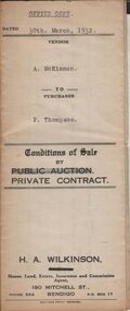 Bendigo Historical Society Inc.
Document - H.A. & S.R. WILKINSON COLLECTION: CONTRACT OF SALE
Conditions of sale by private contract dated 30th March, 1932 between A. McKinnon (seller) and P. Thompson (buyer) for land situate in Murphy Street, Bendigo being the balance of the subdivision unsold of Crown allotment 151,270A, 271A, 271C, 271R, 195, 196, 270C, 271B and 271D described in certificate of title volume 2666 folio 533101, and being the land at present occupied by the vendor, not including the allotments or read showed on plan of subdivision. Together with weatherboard dwelling and all sundry including galvanized iron tank and stand, water trough and loose timber in paddock but does not include any window or verandah blinds. Price 800 pounds.organization, business, h.a. & s.r wilkinson real estate -
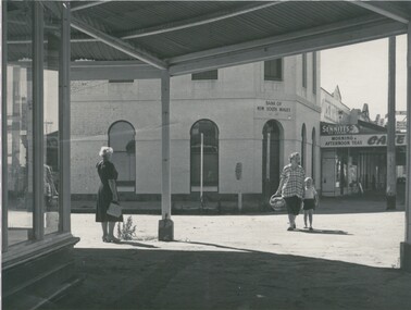 Bendigo Historical Society Inc.
Photograph - STREET SCENE INGLEWOOD, 1950's
Black and white photograph. Street scene showing 2 storey bank, row of shops, taken from footpath with wide verandah over. Two women and one child in image. In image, on 2 storey building 'Bank of New South Wales, Est 1817'. On shops 'Café', 'Bear in mind, Sennitt's Ice Cream', Morning and Afternoon Teas'. On back: ?MP 281'. Circular stamp 'Royal Historical; Society of Victoria, Bendigo Branch'. Hand written 'Mr Harrison' (3). Previous Acc. No. 'MP 281'. James Lerk 10.,03.2000 'Inglewood. Constance Doney with back to photographer. Edith Lunn 5.11.1999 'Bank of NSW, Inglewood'Alan Doneybuildings, bank, bank of new south wales -
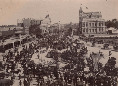 Bendigo Historical Society Inc.
Photograph - PALL MALL PROCESSION
Black and White photograph. The photo shows large procession heading north up Pall Mall. On RH side of image: Law Courts, Union Jack flag flying overhead. Conservatory Gardens just visible, picket fence along footpath. In centre of image: procession with horse drawn floats; float in front of image has large ball above an ornate supporting structure. Written on side of ball ' Gold .tained…' (gold contained?) On LH side of image, 'Harry Davey’ and 'F. Davey' written on shop fronts. All shops along Pall Mall have verandahs. Many people are sitting on balconies and rooftops watching the parade.bendigo, streetscape, pall mall -
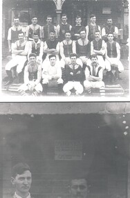 Bendigo Historical Society Inc.
Photograph - HARRY BIGGS COLLECTION: CALIFORNIA GULLY FOOTBALL TEAM, 1900
Photograph of a group of men dressed in a uniform in front of a brick building, there is an ornate verandah post visible in the centre of the group. They are wearing light coloured three-quarter length pants with long socks, most of then have lace - up vests over a long sleeved garment. On the back of this is written Eaglehawk photo, about 1900, California Gully Football team in front of Johnson Reef Hotel, (Rhodes shop 1980?). 2. Close-up of the sign on the wall of the Hotel which reads 'Dr. Jones may be consulted here every Monday at 3.30 PM. If not required no delay will be made'. 3. there are also two small proof photos of the team.person, group, football team, california gully football team, johnson's reef hotel, rhodes shop, dr. jones -
 Bendigo Historical Society Inc.
Photograph - Rae's Hill State School, Rae's Hill, Ironbark
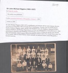
Rae's School was opened on the 22nd April 1861, with 22 students. Mr. John Rae was the Headmaster. By 1919, it was an adjunct of the Violet Street State School.Sepia coloured postcard . Image on front shows twenty-eight male and female students and two young male teachers seated at front. Sign in front of students reads: Central School, Rae's Hill, Form E. 9th February 1919. Students are standing in front of a brick building, with verandah immediately behind them. On back 'Post Card, correspondence and address only'. Kodak printed around space for stamp. Text donated with the photo relates to Sir John Michael Higgins (1862-1937) a metallurgist, government adviser and company director who attended Rae's School, Sandhurst and then Bendigo High School. This photo is not of his era at the School. Written in black pen on back of postcard: 'Rae's Hill School 9th Feb. 1919'rae's common school, rae's school, rae's hill, john rae, barbara rae, 1919 -
 The Beechworth Burke Museum
Photograph, c1900
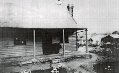
This photograph shows a small timber house in Wooragee. In 1855, the Ovens district made a shift towards farming development that included the sales of land in the Wooragee Valley. This shift came because of miner's demands and concern about stabilising the area around the goldfield. Continual migration needed to be supported, unlucky diggers needed alternative employment, and there was a lack of affordable fresh produce available on the goldfields. Initially, the cost of land in areas like Wooragee was prohibitive, and miners chose to squat rather than overpay for poor land. Throughout the 1850s and 1860s, land reform was a key topic for miners and politicians, as they attempted to improve land access and protect financial interests. This photograph is an example of rural development in the Wooragee area, showing the cottage, tents, and garden beds. While the date is unknown, the image nevertheless links us to the 1850s-1860s story of rural development in Indigo Shire. Black and white rectangular photo, copy of original, printed on paper. wooragee, timber, timber cottage, corrugated iron, cottage, housing, tents, gardening, farming, farming and agriculture, construction, garden bed, flowers, verandah, squatting, tent, field -
 Glen Eira Historical Society
Album - Album page, Munster Avenue, Circa 1972
This photograph is part of the Caulfield Historical Album 1972. This album was created in approximately 1972 as part of a project by the Caulfield Historical Society to assist in identifying buildings worthy of preservation. The album is related to a Survey the Caulfield Historical Society developed in collaboration with the National Trust of Australia (Victoria) and Caulfield City Council to identify historic buildings within the City of Caulfield that warranted the protection of a National Trust Classification. Principal photographer thought to be Trevor Hart, member of Caulfield Historical Society. Most photographs were taken between 1966-1972 with a small number of photographs being older and from unknown sources. All photographs are black and white except where stated, with 386 photographs over 198 pages. This house continues to occupy the property at 5 Munster Avenue Carnegie (Google map image capture Feb 2019).Page 136 of Photograph Album with one landscape photograph of an Edwardian house on Munster Avenue.Handwritten: Munster Street / Avenue [top right] / 136 [bottom right]trevor hart, garden, verandah, bull nosed verandah, edwardian, coloured glass, corrugated iron roof, bay window, gable, chimneys, porch, munster avenue, carnegie, box bay window, weatherboards, cast iron work, timber houses -
 Glen Eira Historical Society
Album - Album page, Neerim Road, Circa 1972
This photograph is part of the Caulfield Historical Album 1972. This album was created in approximately 1972 as part of a project by the Caulfield Historical Society to assist in identifying buildings worthy of preservation. The album is related to a Survey the Caulfield Historical Society developed in collaboration with the National Trust of Australia (Victoria) and Caulfield City Council to identify historic buildings within the City of Caulfield that warranted the protection of a National Trust Classification. Principal photographer thought to be Trevor Hart, member of Caulfield Historical Society. Most photographs were taken between 1966-1972 with a small number of photographs being older and from unknown sources. All photographs are black and white except where stated, with 386 photographs over 198 pages. Property is included the City of Glen Eira's Amendment C190glen as HO177 Ida Villa. As of 18/03/2021, Amendment C190 is noted as "Approval Under Consideration" by the Minister of Planning.Page 147 of Photograph Album with one landscape photograph of a Victorian brick house on Neerim Road.Handwritten: Neerim Road [top left] / 234 [under photo] / 147 [bottom left]trevor hart, neerim road, arched windows, verandah, porch, decorative brackets, bull nosed verandah, cast iron columns, ross land sales, ross, carnegie, victorian style, cast iron work, polychrome bricks, brick houses, tessellated tiled deck, ida villa