Showing 27608 items
matching yarra-river
-
 Stawell Historical Society Inc
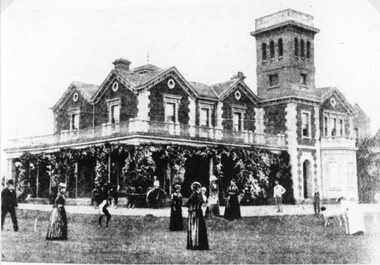
Photograph, "Woodlands" Homestead on Wimmera River near Crowlands owned by William McCulloch 1894
Photograph of Woodlands Homestead on Wimmera River near Crowlands 1894 owned by William McCulloch when photo taken in 1894stawell -
 Kiewa Valley Historical Society
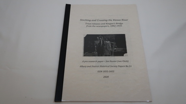
Book - Kiewa River, Stocking and Crossing the Kiewa River by Jan Hunter (nee Chick), 2020
The Chick brothers, Alf, Les and Allan, plus friends, began trout fishing and camping in the Kiewa Valley before the early 1930s. Les continued his connection with the Kiewa River until his death in 1972. Fingerlings were placed in the Kiewa River from the early 1880s. Keegan's Bridge is a crossing near Upper Gundowring and about 4 km south east of Dederang. References to the crossing were made in the early 1900s and a petition presented to Council in 1904 calling for a bridge.The bridge was built and opened in 1907. The photos are of the release of fingerling trout in the Kiewa River, thought to be at Keegan's Bridge. The fingerlings were transported in drums on the back of trucks. The photos are c1940s.The Kiewa Valley has been a popular spot for fishermen, tourists and campers from the 1880s. One of the many attractions has been the excellent fishing along the Kiewa River due to the regular release of fish especially brown trout. This continues to the present day (2020) when a few fish were marked with $$ signs for the lucky fisherman who caught them. This attracts visitors, their families and boosts the economy and dates back to visits at the Tawonga Pub prior to the Kiewa Hydro Electric Scheme.19 page book with black plastic spine and clear plastic cover over the beige paper cover with title , author and black & white photo. Note: In KVHS photo collection there are 4 good quality reproduction photos on photographic paper. These have been produced professionally. These photos of Jan Hunter's are featured on the second page of her book. These also have a letter attached. The book is a pre-research paper & is No 33 of the Albury and District Historical Society Papers. The sub-title is "Trout releases and Keegan's Bridge / from the newpapers, 1882-1935"None on the book but a letter is attached from Jan Hunter, the author as a follow up to the photos she donated. On the photos - On the back: Fujifilm / Fujicolor Crystal Archive / Paper / Production - run codekiewa river; trout; fish; keegan's crossing; keegan's bridge; fingerlings; chick family; camping; tourism -
 Melbourne Tram Museum
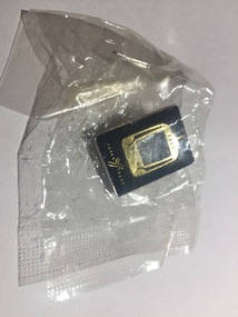
Ephemera - Badge, Yarra Trams, 2001
Lapel Badge in a sealed plastic bag - with the front image of a tram with the number 2001 in the top of the tram and the name of Yarra trams on the bottom of the badge. Has a pin on the rear to enable to be fixed to an item of clothing.trams, tramways, yarra trams, badges -
 Greensborough Historical Society
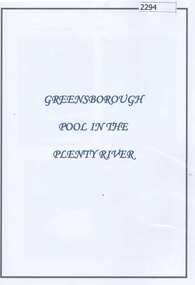
Folder (article and photographs), Greensborough Pool in the Plenty River / compiled by Marilyn Smith, 1937o
Society member Marilyn Smith has compiled a collection of historic articles from local newspapers, historic and modern photographs of the swimming pool in the Plenty River Greensborough, opened in 1937. The Pool is still visible from the Main Street bridge and present day photographs are also included. A short story by Gary Partington tells of his memories of the Plenty River as he was growing up.An historical view of the Greensborough pool in the Plenty River.Folder with pink plastic cover. 12 pages of text and photographs.plenty river, greensborough swimming pool, marilyn smith, gary partington -
 Lakes Entrance Regional Historical Society (operating as Lakes Entrance History Centre & Museum)
Photograph, Phillip Hancock, January 1915 c
Black and white photograph showing small launch beside river and large Aboriginal canoe tree in background and eighteen adults and two children, James, Maud, Eva, May, Mabel Howlett, Fred, Marion, Alf, Gladys Legg, Carrie Froud, Jessie Bly, Lena Brideson, George Bull, Will Bell, Jim Thompson, Mr Wilson on the bank of the Tambo River Gippsland Victoriagenealogy -
 Eltham District Historical Society Inc
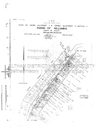
Document - Survey Plan, Country Roads Board, SP 6561, Eltham-Yarra Glen Road; Park Rd to Bellevue Rd, 1957
1957 C.R.B. Plan of Survey of Parts of Crown Allotment 1 & Crown Allotment F, Section II Parish of Nillumbik, County of Evelyn Eltham-Yarra Glen Road, Shire of Eltham Shows Surveyor field notes, property ownership and building type and construction.eltham-yarra glen road, country roads board, eltham, main road, survey plan, 1957, a.r. thomas, b. & b.d. hearn, b.g. anderson, bellevue road, e.m. pitts, f.a. m. macrae, g.e. & b. moulder, j. bromley, j.m. & s.g. johnstone, k.f. pitts, l.c. docksey, m. & e.c.w. baart, m.p. bromley, n.r. ord, p.j. & g.e. murphy, park road, r.a. bruce, r.a. macbeth, r.w. shearing, railway road, s.e. & y.p. houghton, w.k. bell, w.s.r. & f.n. toley, neil webster collection -
 Eltham District Historical Society Inc
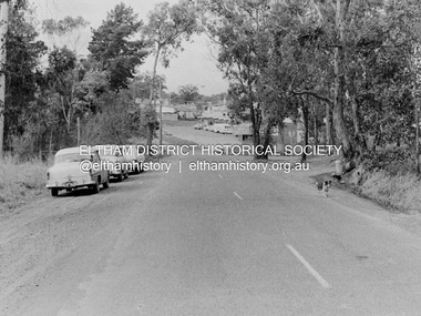
Photograph, Barry Philp, Eltham-Yarra Glen Road, Research, Vic, c.1967
View looking north along Eltham-Yarra Glen Road towards intersection with Research-Warrandyte Road and Research shops, c.1967. Three cars on the left, two FC Holden sedans (1958-1960) and a Holden HD Station Sedan (1965-1966)In digital metadata "My beautiful picture"cars, eltham-yarra glen road, holden fc, holden hd, main road, research (vic.), research shops, research-warrandyte road -
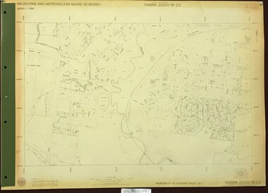
 Greensborough Historical Society
Map, Melbourne and Metropolitan Board of Works. Survey Division, MMBW, Yarra 2500 / 17.27. Central Hurstbridge, 1978_02
Melbourne and Metropolitan Board of Works. Yarra 2500 [base map] 17-27. Central Hurstbridge. Parish of Greensborough 2724, Municipalities of Diamond Valley 257, Eltham 238 and Whittlesea 239. Prominent streets include: Anzac Avenue and Hurstbridge-Arthurs Creek Road. MMBW Map in 1:2500 [scale] series. Cream parchment with green tape reinforcing on edges and punched holes on left edge.mmbw, melbourne and metropolitan board of works, shire of diamond valley, hurstbridge - maps -
 Greensborough Historical Society
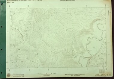
Map, Melbourne and Metropolitan Board of Works. Survey Division, MMBW, Yarra 2500 / 16.25. Wattle Glen, 1978_07
Melbourne and Metropolitan Board of Works. Yarra 2500 [base map] 16-25. Wattle Glen. Municipalities of Diamond Valley 257 and Eltham 238. Prominent streets include: Nimmo Road, Broad Gully Road and Heidelberg-Kinglake Road. Includes Yulong Park.MMBW Map in 1:2500 [scale] series. Cream parchment with green tape reinforcing on edges and punched holes on left edge.mmbw, melbourne and metropolitan board of works, shire of diamond valley, wattle glen - maps -
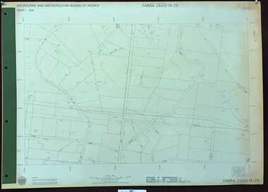
 Greensborough Historical Society
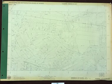
Map, Melbourne and Metropolitan Board of Works. Survey Division, MMBW, Yarra 2500 / 14.20. Montmorency, Sherbourne Road, 1977_06
Melbourne and Metropolitan Board of Works. Yarra 2500 [base map] 14.20. Montmorency, Sherbourne Road. Municipality of Diamond Valley 257 and Eltham 238. Prominent streets: Sherbourne Road, Karingal Drive and Calrossie Avenue. Features include Montmorency Station and Meruka Park.MMBW Map in 1:2500 [scale] series. Cream parchment with green tape reinforcing on edges and punched holes on left edge.mmbw, melbourne and metropolitan board of works, shire of diamond valley, montmorency - maps -
 Eltham District Historical Society Inc
Photograph, Construction of new bridge over the Plenty River, Main Road, Lower Plenty, c.Aug. 1966
Construction of the Main Road bridge over the Plenty River. Includes structural members, construction personnel, vehicles and a Clarke mobile crane.Local significanceBlack and white printlower plenty, main road, plenty river, bridge, bridge construction, civil engineering, cranes, mobile cranes -
 Greensborough Historical Society
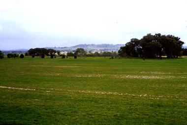
Slide - Photograph, John Ramsdale, River flood plain looking west: Slide 67, 1990s
Photograph shows a rural scene with water over ground. This is the Plenty River flood plain looking west, Yan Yean or MerndaPart of the John Ramsdale collection of slides and audio visual material.Colour photograph scanned from slide.No maker's marks. No caption on slide.plenty river, yan yean, mernda -
 Greensborough Historical Society
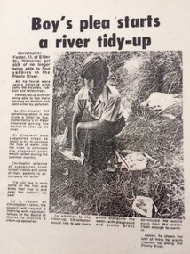
Newspaper Clipping - Digital Image, Diamond Valley News, Boy's plea starts a river tidy-up, 1972c
A young Christopher Foster was sick of finding rubbish along the banks of the Plenty River. He wrote to Council and a clean up was started.Digital copy of newspaper clipping, black and white text and image.plenty river, chris foster -
 Greensborough Historical Society
Advertising Leaflet, 3/19 River Street Briar Hill, 23/11/2012
3/19 River Street Briar Hill. 3 bedroom home, private sale, sold 23 November 2012 for $445,000Real estate advertising leaflet, 1 sheet, printed in colour both sidesriver street briar hill -
Tatura Irrigation & Wartime Camps Museum
Booklet, River Improvement & Land Drainage, 1952
River improvement and land drainage and flood protection with spectial reference to the nature and operation of land drainage legislation in Great Britain 1952Grey cover, black writing. Includes fold out mapsirrigation, books, history, local -
 Greensborough Historical Society
Photograph (copy), Plenty River Tea Gardens, 1929c
Plenty River Tea Gardens were located on east side of Main Street near St Helena Road intersection. [Ref: The Age 18/2/1929 page 3 - Greensborough - Comfortable Home. 6 rooms. large verandas. ½ acre. S O bungalow. Lovely spot. 4 minutes station. Furnished or unfurnished or will sell reasonable. River Plenty Tea Gardens. Phone Gr. 17]Two black & white photographsplenty river tea gardens, greensborough tea rooms -
Lakes Entrance Regional Historical Society (operating as Lakes Entrance History Centre & Museum)
Postcard, Sherwood, 1907 c
Black and white postcard of the bridge over the Brodribb River near Orbost VictoriaBrodribb River 6.4.07waterways, bridges -
Lakes Entrance Regional Historical Society (operating as Lakes Entrance History Centre & Museum)
Postcard, 1920 c
One of the series of postcards used in the tourist industryPostcard of scene of Mitchell River with fences in the foreground and in the background bridge and Bairnsdale VictoriaThe Mitchell River Bairnsdalehouses, waterways -
 Greensborough Historical Society
Map, Melbourne and Metropolitan Board of Works. Survey Division, MMBW, Yarra 2500 / 15.23. Diamond Creek Reserve, 1978_02
Melbourne and Metropolitan Board of Works. Yarra 2500 [base map] 15.23. Hurstbridge. Municipality of Diamond Valley 257. Prominent streets include: Challenger Street, James Cook Drive and Ryans Road / Main Street. Features include the Diamond Creek and Diamond Creek Reserve.MMBW Map in 1:2500 [scale] series. Cream parchment with green tape reinforcing on edges and punched holes on left edge.mmbw, melbourne and metropolitan board of works, shire of diamond valley, diamond creek - maps -
 Greensborough Historical Society
Map, Melbourne and Metropolitan Board of Works. Survey Division, MMBW, Yarra 2500 / 14.25. Plenty, Heard Road, 1978_02
Melbourne and Metropolitan Board of Works. Yarra 2500 [base map] 14.25. Plenty, Heard Road. Parishes of Greensborough 2724, Nillumbik 3310 and Morang 3183. Municipality of Diamond Valley 257. Prominent streets include: Heard Road, Seymour Drive and Yan Yean Road.MMBW Map in 1:2500 [scale] series. Cream parchment with green tape reinforcing on edges and punched holes on left edge.mmbw, melbourne and metropolitan board of works, shire of diamond valley, plenty - maps -
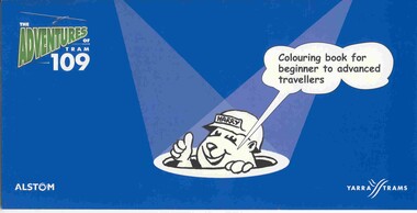 Ballarat Tramway Museum
Domestic object - Colouring Book, Yarra Trams and Warwick Hook, "The Adventures of Tram 109", Dec 2003?
12 page colouring book, with heavy card covers, titled "The Adventures of Tram 109", with illustrations by Warwick Hook, published at the time of the opening to Box Hill of route 109 from Mont Albert. Published jointly by Alstom and Yarra Trams. Features 10 pages of landscape size cartoons each featuring a single story line and a four panel cartoon, with a title and Harry the construction worker panel at the ends. Has Yarra trams logo and web site on the rear cover.tram, trams, box hill, yarra trams, route 109 -
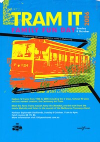 Melbourne Tram Museum
Pamphlet, Yarra Trams, "Tram It - 2006 - Family Fun Day", Sep. 2006
Full colour pamphlet A4 printed on gloss paper titled "Tram It - 2006 - Family Fun Day", advertising the Yarra Trams event at Docklands on 8/10/2006 to celebrate 100 years of electric trams in Melbourne. Has an image of V214, event details and planning. Has the Yarra Trams 100 years logo and their logo along the bottom of sheet. 2nd copy and 2 A3 copies added 26/6/17 - from donation by Ron Scholten.trams, tramways, yarra trams, 100 years of electric trams, docklands, displays, tram v214 -
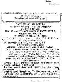 Greensborough Historical Society
Newspaper - Newspaper Clipping (copy), The Argus, Sale: Wattle Bend ... on Plenty River 1925, 14/03/1925
An advertisement for the sale of "Wattle Bend" on the Plenty River, a guest house and orchard farm being offered for sale by Mr J. A. Bush in 1925Mr J. A. Bush was formerly known as Johannes Adem Bosch, an early Greensborough orchardist1 page copy of newspaper advertisement.plenty river, bosch family, bush family, wattle bend -
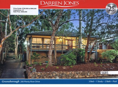 Greensborough Historical Society
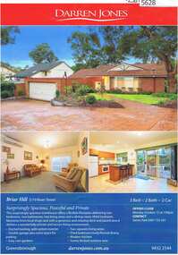
Advertising Leaflet, Darren Jones, 20 Plenty River Drive Greensborough, 16/12/2017
20 Plenty River Drive Greensborough. Three bedroom home, sold for $830,000 in December 2017. Previous sales: January 1980, $15,250.Real estate advertising leaflet, 1 sheet, printed in colour both sides. plenty river drive greensborough -
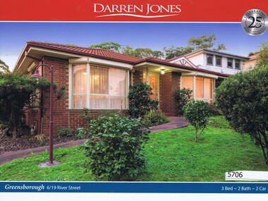 Greensborough Historical Society
Advertising Leaflet, Darren Jones, 6/19 River Street Greensborough, 28/07/2018
6/19 River Street Greensborough. Three bedroom unit, sold for $830,000 in July 2018. Previous sales: November 1998, $35,000.Real estate advertising leaflet, 1 sheet, printed in colour both sides. river street greensborough -
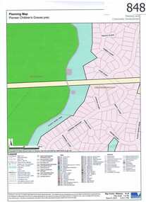 Greensborough Historical Society
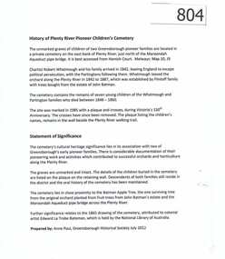
Map, Plenty River Children's Cemetery - location map, 1848-1860
The unmarked graves of the children of two Greensborough pioneer families lie in a private cemetery on the Plenty River. Burials occurred between 1848 and 1860.The significance lies in the association with two of the pioneer families of the Greensborough district. Descendants of both families still live in the area.One page map accompanies article item #804 -
 Greensborough Historical Society
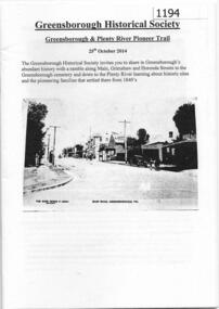
Booklet, Greensborough Historical Society, Greensborough and Plenty River Pioneer Trail, 25/10/2014
This booklet outlines the October 2014 guided walk through Greensborough, visiting Main and Grimshaw Streets, the Greensborough cemetery and along the Plenty River.24 pages, balck and white illus.greensborough historical society, plenty river heritage trail -
 Greensborough Historical Society
Article, History of Plenty River Children's Cemetery; by Anne Paul, 1848-1860
The unmarked graves of the children of two Greensborough pioneer families lie in a private cemetery on the Plenty River. Burials occurred between 1848 and 1860.The significance lies in the association with two of the pioneer families of the Greensborough district. Descendants of both families still live in the area.2 printed pages of text, one page map (item 848).pioneer childrens cemetery, plenty river, partington, whatmough -
 Yarra Glen & District Historical Society
Black and white photographs, Yarra Glen railway crossing c.1900
Black and white photograph in light brown card slip case. The slip case has an image on the front cover of a head and shoulder bust. The photograph was taken about 1900 from the tower of the Grand Hotel looking down upon the Victoria Hall and the railway crossing. In the lower left corner is W.J.Dawborn's General Store. In front of the store is a horse and spring dray and another horse hitched to a veranda post. Next to the store is the Victoria Hall and beyond that a water trough. The railway crossing is in the centre of the picture with two railway cattle trucks next to the cattle yards. Beyond the railway on the left hand side is the property later known as 'River View'. Beyond the river lined with trees are the Yering flats across which can be seen the long trestle railway bridge. In the foreground of the picture is Bell Street lined with trees in wooden tree guards.yarra glen, victoria hall, railway crossing, river view, general store, w j dawborn, horse and cart, horse and dray, spring dray, horse hitched, hitching post, water trough, railway truck, cattle truck, cattle yards, stock yards, yering flats, trestle railway bridge, trestle bridge -
 Eltham District Historical Society Inc
Document - Survey Plan, Country Roads Board, SP 6559-6560, Eltham-Yarra Glen Road; Elsa Ct to Luck St, 1957
1957 C.R.B. Plan of Survey of Part of Crown Portion 13 Section 4 and Crown Allotment 1 Section 1 Parish of Nillumbik, County of Evelyn Eltham-Yarra Glen Road, Shire of Eltham Shows Surveyor field notes, property ownership and building type and construction.eltham-yarra glen road, country roads board, eltham, main road, survey plan, 1957, a.m. & a.a. iowerson, a.mcg. hepburn, cecil street, coffee lounge, diamond street, e.g. murrell, elsa court, h.b. woodhead, j.c. & s.i. harding, la ronde, luck street, r.m. & v.m. white, r.n. mowatt, the board of land & works, w.g. hains, neil webster collection