Showing 123820 items matching "main-road"
-
 Eltham District Historical Society Inc
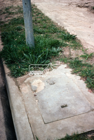
Photograph, Foothpath and kerb damage, Bainbridge Drive, Eltham, 3 Sep 1981
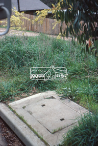
Roll of film taken by Eltham Shire Council officers of roads and houses in the Eltham East area, 3 September 1981 prior to construction of new water main; including views of existing damage to footpaths and gutters and general views of Beard Street. These images provide a perspective of housing estate developments and changes in housing styles and road development which began sweeping in from the mid 1970s with increasing urbanisation of what was once more outlying suburbs and regions.35mm colour positive transparency (1 of 28) Mount - Kodak Kodachrome Cardeltham, infrastructure, roads, bainbridge drive, footpaths and gutters -
 Eltham District Historical Society Inc
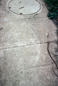
Photograph, Foothpath and kerb damage, Bainbridge Drive, Eltham, 3 Sep 1981
Roll of film taken by Eltham Shire Council officers of roads and houses in the Eltham East area, 3 September 1981 prior to construction of new water main; including views of existing damage to footpaths and gutters and general views of Beard Street. These images provide a perspective of housing estate developments and changes in housing styles and road development which began sweeping in from the mid 1970s with increasing urbanisation of what was once more outlying suburbs and regions.35mm colour positive transparency (1 of 28) Mount - Kodak Kodachrome Cardeltham, infrastructure, roads, bainbridge drive, footpaths and gutters -
 Eltham District Historical Society Inc
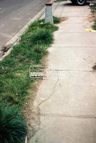
Photograph, Foothpath and kerb damage, Bainbridge Drive, Eltham, 3 Sep 1981
Roll of film taken by Eltham Shire Council officers of roads and houses in the Eltham East area, 3 September 1981 prior to construction of new water main; including views of existing damage to footpaths and gutters and general views of Beard Street. These images provide a perspective of housing estate developments and changes in housing styles and road development which began sweeping in from the mid 1970s with increasing urbanisation of what was once more outlying suburbs and regions.35mm colour positive transparency (1 of 28) Mount - Kodak Kodachrome Cardeltham, infrastructure, roads, bainbridge drive, footpaths and gutters -
 Eltham District Historical Society Inc
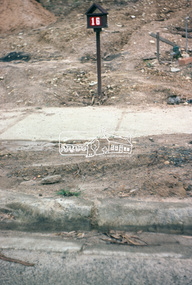
Photograph, Foothpath and kerb damage, Bainbridge Drive, Eltham, 3 Sep 1981
Roll of film taken by Eltham Shire Council officers of roads and houses in the Eltham East area, 3 September 1981 prior to construction of new water main; including views of existing damage to footpaths and gutters and general views of Beard Street. These images provide a perspective of housing estate developments and changes in housing styles and road development which began sweeping in from the mid 1970s with increasing urbanisation of what was once more outlying suburbs and regions.35mm colour positive transparency (1 of 28) Mount - Kodak Kodachrome Cardeltham, infrastructure, roads, bainbridge drive, footpaths and gutters -
 Eltham District Historical Society Inc
Photograph, Foothpath and kerb damage, Madine Way, Eltham, 3 Sep 1981
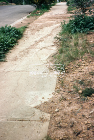
Roll of film taken by Eltham Shire Council officers of roads and houses in the Eltham East area, 3 September 1981 prior to construction of new water main; including views of existing damage to footpaths and gutters and general views of Beard Street. These images provide a perspective of housing estate developments and changes in housing styles and road development which began sweeping in from the mid 1970s with increasing urbanisation of what was once more outlying suburbs and regions.35mm colour positive transparency (1 of 28) Mount - Kodak Kodachrome Cardeltham, infrastructure, roads, footpaths and gutters, madine way -
 Eltham District Historical Society Inc
Photograph, Foothpath and kerb damage, Madine Way, Eltham, 3 Sep 1981
Roll of film taken by Eltham Shire Council officers of roads and houses in the Eltham East area, 3 September 1981 prior to construction of new water main; including views of existing damage to footpaths and gutters and general views of Beard Street. These images provide a perspective of housing estate developments and changes in housing styles and road development which began sweeping in from the mid 1970s with increasing urbanisation of what was once more outlying suburbs and regions.35mm colour positive transparency (1 of 28) Mount - Kodak Kodachrome Cardeltham, infrastructure, roads, footpaths and gutters, madine way -
 Eltham District Historical Society Inc
Photograph, Madine Way, Eltham, 3 Sep 1981
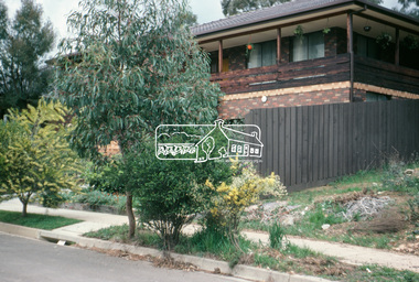
Roll of film taken by Eltham Shire Council officers of roads and houses in the Eltham East area, 3 September 1981 prior to construction of new water main; including views of existing damage to footpaths and gutters and general views of Beard Street. These images provide a perspective of housing estate developments and changes in housing styles and road development which began sweeping in from the mid 1970s with increasing urbanisation of what was once more outlying suburbs and regions.35mm colour positive transparency (1 of 28) Mount - Kodak Kodachrome Cardeltham, infrastructure, roads, madine way, tadema park -
 Eltham District Historical Society Inc
Photograph, Beard Street, Eltham, 3 Sep 1981
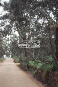
Roll of film taken by Eltham Shire Council officers of roads and houses in the Eltham East area, 3 September 1981 prior to construction of new water main; including views of existing damage to footpaths and gutters and general views of Beard Street. These images provide a perspective of housing estate developments and changes in housing styles and road development which began sweeping in from the mid 1970s with increasing urbanisation of what was once more outlying suburbs and regions.35mm colour positive transparency (1 of 28) Mount - Kodak Kodachrome Cardeltham, infrastructure, roads, beard street, frank street, shalbury avenue -
 Eltham District Historical Society Inc
Photograph, Beard Street, Eltham, 3 Sep 1981
Roll of film taken by Eltham Shire Council officers of roads and houses in the Eltham East area, 3 September 1981 prior to construction of new water main; including views of existing damage to footpaths and gutters and general views of Beard Street. These images provide a perspective of housing estate developments and changes in housing styles and road development which began sweeping in from the mid 1970s with increasing urbanisation of what was once more outlying suburbs and regions.35mm colour positive transparency (1 of 28) Mount - Kodak Kodachrome Cardeltham, infrastructure, roads, beard street -
 Eltham District Historical Society Inc
Photograph, Beard Street, Eltham, 3 Sep 1981
Roll of film taken by Eltham Shire Council officers of roads and houses in the Eltham East area, 3 September 1981 prior to construction of new water main; including views of existing damage to footpaths and gutters and general views of Beard Street. These images provide a perspective of housing estate developments and changes in housing styles and road development which began sweeping in from the mid 1970s with increasing urbanisation of what was once more outlying suburbs and regions.35mm colour positive transparency (1 of 28) Mount - Kodak Kodachrome Cardeltham, infrastructure, roads, beard street, frank street -
 Eltham District Historical Society Inc
Photograph, Beard Street, Eltham, 3 Sep 1981
Roll of film taken by Eltham Shire Council officers of roads and houses in the Eltham East area, 3 September 1981 prior to construction of new water main; including views of existing damage to footpaths and gutters and general views of Beard Street. These images provide a perspective of housing estate developments and changes in housing styles and road development which began sweeping in from the mid 1970s with increasing urbanisation of what was once more outlying suburbs and regions.35mm colour positive transparency (1 of 28) Mount - Kodak Kodachrome Cardeltham, infrastructure, roads, beard street, grove street, valonia drive, wycliffe crescent, livingstone road -
 Eltham District Historical Society Inc
Photograph, Beard Street, Eltham, 3 Sep 1981
Roll of film taken by Eltham Shire Council officers of roads and houses in the Eltham East area, 3 September 1981 prior to construction of new water main; including views of existing damage to footpaths and gutters and general views of Beard Street. These images provide a perspective of housing estate developments and changes in housing styles and road development which began sweeping in from the mid 1970s with increasing urbanisation of what was once more outlying suburbs and regions.35mm colour positive transparency (1 of 28) Mount - Kodak Kodachrome Cardeltham, infrastructure, roads, beard street -
 Eltham District Historical Society Inc
Photograph, Beard Street, Eltham, 3 Sep 1981
Roll of film taken by Eltham Shire Council officers of roads and houses in the Eltham East area, 3 September 1981 prior to construction of new water main; including views of existing damage to footpaths and gutters and general views of Beard Street. These images provide a perspective of housing estate developments and changes in housing styles and road development which began sweeping in from the mid 1970s with increasing urbanisation of what was once more outlying suburbs and regions.35mm colour positive transparency (1 of 28) Mount - Kodak Kodachrome Cardeltham, infrastructure, roads, beard street -
 Whitehorse Historical Society Inc.
Document, 'Willowbank', 1985
Notes by Jean Uhl on interview, 1985, about 'Willowbank'Notes by Jean Uhl on interview, 1985, about 'Willowbank', used to be called 'Willowbridge' (named 'Willowbridge' by Mrs B. Rawson). Home was built 1880, land originally subdivided by Gerard Letts, German family thought to be original builders. Situated at 3 Moore Road, Vermont. 1978 purchased by R.B. Evans,Notes by Jean Uhl on interview, 1985, about 'Willowbank'willowbank', uhl, jean, letts, gerard, rawson, b. (mrs), evans, r.b. (mr), moore street, vermont, no. 3 -
 National Wool Museum
Work on paper - Officials' Uniform Design Drawings, Wendy Powitt, c. 1992
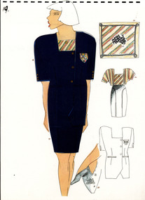
A set of laminated A3 sketchbook pages depicting designs for the 1992 Barcelona Olympic Women's Opening/Closing Ceremony Uniform designed by Wendy Powitt. On the 1992 Barcelona Olympic Games donor Doug Pleasance wrote- The 1992 Barcelona Olympic Games saw an evolutionary change in designer selection. A Declaration of Interest Form was communicated to over forty potential designers. The task and especially tight timelines that were involved deterred many aspirants, however, there remained eight designers with the potential we were seeking. These eight designers were paid $3,000 per submission and the winning designer, Wendy Powitt, was paid $15,000. For the first time the judging panel included two athletes, one male swimmer and one female basketballer, their influence was pivotal. The Official Uniform was used for both travel and official functions. This included a tailored blazer and trouser/skirt set (all water repellent) by Fletcher Jones in pure olive green faille fabric by Foster Valley, a cotton PE formal shirt by Pelaco, pure wool knitwear by Spangaro, a printed wool tie by TD Noone, wool nylon socks by Holeproof and footwear by Hush Puppy.8122.1 - A laminated A3 sketchbook page depicting a design for the Men's 1992 Barcelona Olympics Australian Official's Uniform. The main drawing shows the design for blue suit pants and blazer with six gold buttons, a yellow shirt and a red, green, yellow and cream striped tie. To the left of the main image are four smaller detail drawings of the belt buckle, gold bottons, blazer and shoes. 8122.2 - A laminated A3 sketchbook page depicting a design for the Women's 1992 Barcelona Olympics Australian Official's Uniform. The main drawing shows the design for a blue elbow length, square necked blazer with gold buttons on both the front of the jacket and sleeves paired with a blue pencil skirt and a red, green, yellow and cream shirt. To the right of the main drawing are four smaller detail drawings showing the pattern for a scarf, the striped shirt, the blazer and the shoes. 1992 barcelona olympics, sport, athletes, fashion, design, artwork, drawing, uniform -
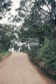
 Eltham District Historical Society Inc
Negative - Photograph, Eltham, Vic, c.1890
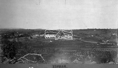
View looking northeast from present day Ely Street (near intersection of present day Cronus Court and Porter Street) across what will become the site of Eltham High School towards Main Road showing the Eltham Courthouse and Police station. View is very similar to the sketch of Eltham published in 'The Illustrated Australasian News', December 26, 1884, p212. Note the large bluestone cell block behind police house and stable. George Knapman's Shoeing Forge next to the courthouse and the concentration of buildings around the Evelyn Hotel and Watson's Eltham Hotel on opposite sides of Main Road at Pitt street. Also note George Stebbing's cottage (c.1860) on Pitt Street behind the courthouse and 'Sunnyside' (home of W.J. Taylor built c.1885) at the top of the hill on Bible Street. In the foreground are orchards running up to the main street, Maria Street and also between Brougham Street and Dalton Street bordered by Bible Street.This photo forms part of a collection of photographs gathered by the Shire of Eltham for their centenary project book,"Pioneers and Painters: 100 years of the Shire of Eltham" by Alan Marshall (1971). The collection of over 500 images is held in partnership between Eltham District Historical Society and Yarra Plenty Regional Library (Eltham Library) and is now formally known as the 'The Shire of Eltham Pioneers Photograph Collection.' It is significant in being the first community sourced collection representing the places and people of the Shire's first one hundred years.Digital image 4 x 5 inch B&W Negshire of eltham pioneers photograph collection, eltham, 1890, bible street, brougham steet, dalton street, eltham courthouse, eltham hotel, evelyn hotel, franklin street, grant house, knapmans forge, main road, maria street, orchards, police residence, police station, pre 1900, stebbing cottage, sunnyside, w.b. andrew corn store, watsons hotel, little eltham -
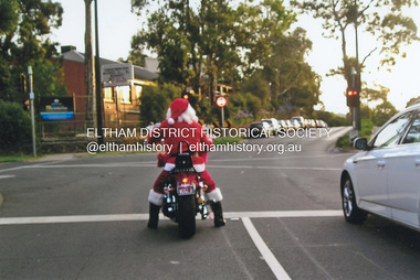 Eltham District Historical Society Inc
Photograph, Fay Bridge, Santa Claus is coming to Eltham, December 2011
Main Road at Dudley Street and Santa Claus is coming to town. Unfortunately, after Santa had passed through, late on Christmas Day afternoon a strong storm also swept in from the south bringing torrential rain and large hail resulting in flash flooding and wide spread storm damage.fay bridge collection, 2011-12, christmas, dudley street, eltham, main road, santa claus -
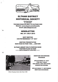 Eltham District Historical Society Inc
Newsletter, Newsletter, No. 211 July 2013
Contents: • Next meeting, Presentation: Main Road Eltham 1968…..And Now • July Meeting • July Excursion – Mud Bricks, Pise and Other ‘Character Houses’ • Nillumbik Reconciliation Plaques • A Busy Time for Enquiries, Donations and Other Things • Mac Ball • Former Hat Factory • Avenue of Honour • And Also The Shire of Eltham Historical Society was formed in October 1967. The first newsletter of the Society was issued May 1978 and has been published continuously ever since on a bi-monthly basis. With the cessation of the Shire of Eltham in late 1994, the Society's name was revised to Eltham District Historical Society and this name first appeared with issue No. 103, July 1995. The collection of the Society's newsletters provides a valuable resource on the history of the Society's activities, office bearers and committee members, guest speakers and subjects of historical interest pertinent to the former Shire of Eltham and the Eltham District.A4 photocopied newsletter distributed to membersnewsletter, eltham district historical society, shire of eltham historical society -
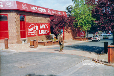 Eltham District Historical Society Inc
Photograph, Pedestrian access upgrade, Pryor Street, Eltham, c. Oct 1987
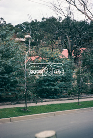
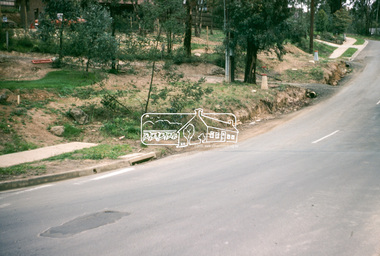
Looking down Pryor Street towards the intersection with Main Road, Mac's Liquor on left. Shows upgraded footpath area with new paving and planter boxes. Date based on other similar display panels visible in images of the Shire of Eltham display at the Eltham Community Festival, 7 November 1987.Colour photographeltham, main road, shire of eltham, infrastructure development, commercial place, display panel, eltham festival, mac's liquor, pryor street -
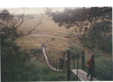 Sunbury Family History and Heritage Society Inc.
Photograph, Catanery Bridge, Bulla, c1980s
The narrow swing catanery bridge was built behind the school across the Deep Creek downstream from the bluestone Bulla Bridge. It was built so that children who lived on the south side of Bulla Township could access the school more easily and in shorter time than if they had to go by the main roads.The bridge was constructed in the days when most children walked to school. The use of this bridge cut the children's travel time and distance to school quite considerably and was used for many years until the school was closed in 1996.A coloured photograph of the children on a narrow swing bridge and the path they used to approach the bridge over open ground. bulla primary school, swing bridge, bridges, catanery bridge -
 Phillip Island and District Historical Society Inc.
Photograph, Bryant West, 1930
One of a collection of over 400 photographs in an album commenced in 1960 and presented to the Phillip Island & Westernport Historical Society by the Shire of Phillip IslandPhotograph looking down Cemetery Road,)unmade (now Coghlan Road) near Rhyll, lined with Gum Trees - early 1930's - car in centrelocal history, photography, photographs, cemetery road, rhyll, black & white photograph, roads, gum trees, cars, cemetery road to be renamed coghlan road, coghlan road phillip island, john jenner, bryant west -
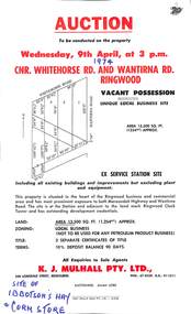 Ringwood and District Historical Society
Flyer, Flyer advertising auction sale of ex service station site in Ringwood, Victoria - 1974
Single page advertisement for auction sale of restricted business site, corner of Whitehorse Road and Wantirna Road, Ringwood, Victoria, on Wednesday, 9th April (1974).Advertisement includes location map and terms of sale of 3 separate certificates of title on land zoned as Restricted Business (Not to be used for any petroleum product business). Sole Agents - K.J. Mulhall Pty. Ltd., 358 Lonsdale Street, Melbourne (Telephone) 67 8338, A.H. 91 1511. Auctioneer - Allan Lord. Handwritten notation describes this as originally the site of Ibbotson's Hay and Corn Store. -
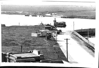 Port Melbourne Historical & Preservation Society
Photograph - Short Road ferry crossing Yarra from west side, 1930
Black and white photograph of Short Road ferry crossing the Yarra, taken from the west side. Roads on both sides with cars. Buildings on west side.piers and wharves, short road ferry, williamstown road -
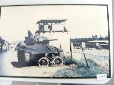 National Vietnam Veterans Museum (NVVM)
Photograph, Tank And A Bike
A mounted coloured photograph of a tank parked on the side of a road. A bike rests against the front of the tank. The tank is outside a Military compound and there is civilian traffic on the roadphotograph, military compound, armoured vehicle -
Whitehorse Historical Society Inc.
Article, $80m tunnel plan to solve eastern suburb bottleneck, 2004
Article about proposal to build two tunnels in Springvale Road, Nunawading under Whitehorse Road and the railway line.Article about proposal to build two tunnels in Springvale Road, Nunawading under Whitehorse Road and the railway line. The tunnels are proposed by Whitehorse City Council.Article about proposal to build two tunnels in Springvale Road, Nunawading under Whitehorse Road and the railway line. springvale road, nunawading, whitehorse road, nunawading, city of whitehorse, duff, noelene, springvale road tunnels -
Whitehorse Historical Society Inc.
Letter - Correspondence, Municipal rate correspondence, 1933
Municipal correspondence re rates for shops and Lots 1 & 2 Railway Road, Blackburn and correspondence re rates on Lot 23 Central Road, BlackburnMunicipal correspondence re rates for shops and Lots 1 & 2 Railway Road, Blackburn and correspondence re rates on Lot 23 Central Road, BlackburnMunicipal correspondence re rates for shops and Lots 1 & 2 Railway Road, Blackburn and correspondence re rates on Lot 23 Central Road, Blackburnrates, davey, blanche edith, cummins, e (mrs), central road, blackburn, railway road, blackburn -
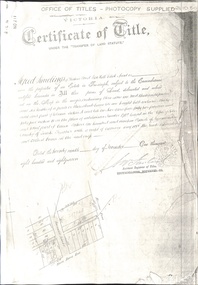 Whitehorse Historical Society Inc.
Document - Land Title, Certificate of Title, 29/11/1887
Photocopies of land titles involved in subdivision of land on the north-west corner of Whitehorse Road and Mitcham Road including Britannia Street. A list of purchasers is included.mitcham road, mitcham, whitehorse road, britannia street, rawlings, alfred, frost, john, richards, thomas, leech, george arthur, smith, reed, richard louis, young, frederick, hughes, doery, george henry, mitcham primary school, no. 2904, land subdivision -
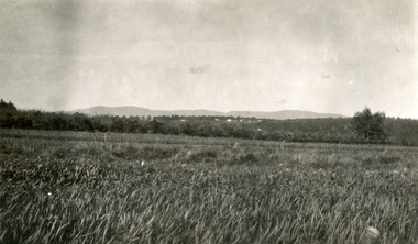 Whitehorse Historical Society Inc.
Photograph, Jones Flower Farm
Jones Family Collection - NP2565 to NP2606. See also ND3831.Black and white photograph of daffodils growing on Jones' Flower Farm in Mt Pleasant Road, Nunawading, looking towards the Dandenongs with Mitcham Road in middle distance.jones, bette, walter, rolf, geoffrey, arthur, keith, lionel, muriel, jones flower farm, mount pleasant road nunawading -
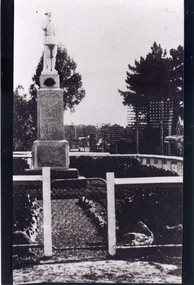 Whitehorse Historical Society Inc.
Photograph, Mitcham War Memorial
Black/white - Front view of Mitcham War memorial showing gate in the fence. Memorial was in Whitehorse Road, Mitcham but moved to Halliday Park in Mitcham Roadwar memorial mitcham, armstrong, ian