Showing 123820 items matching "main-road"
-
 Whitehorse Historical Society Inc.
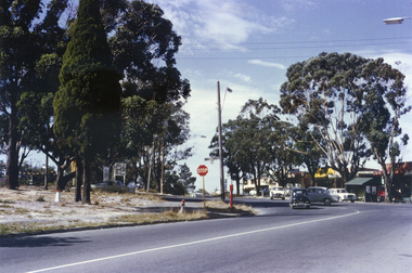
Photograph, Vermont Intersection C.1967, C.1967
Part of Tim Shambrook's Collection for 'This is Vermont'. Not used.Coloured photo of Intersection of Canterbury, Mitcham & Boronia Roads, Vermont, taken from Mitcham Road, showing Vermont Shops and St. Lukes Church on left.st. lukes anglican church, vermont, canterbury road, vermont., mitcham road, boronia road, shambrook, tim -
 Whitehorse Historical Society Inc.
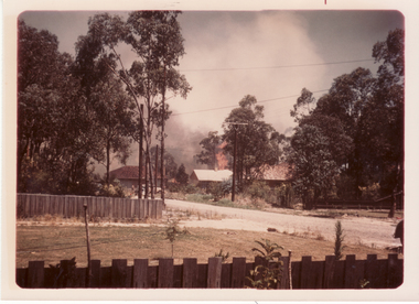
Photograph, Bushfire in Heatherdale
Coloured photo of Bushfire in Heatherdale, 1962. This fire came through from Kinglake, to Warrandyte, to Mitcham, crossing Whitehorse Road and burnt out at Canterbury Road.bushfires, heatherdale, mitcham -
 Whitehorse Historical Society Inc.
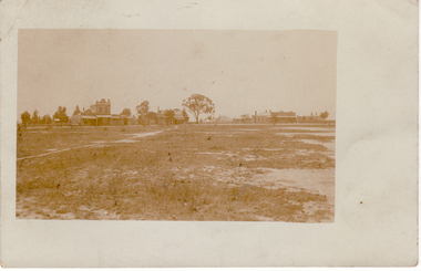
Postcard, Mitcham Shopping Centre, 1910 - 1920
Black and white postcard of Mitcham Shopping Centre, North Side 1910 - 1920. - Cross Roads - Whitehorse and Mitcham Roads| - Prominent building is W.Morris grocermorris w., mitcham shopping centre -
 Kew Historical Society Inc
Plan, Studley Heights Estate, 1936
Pru Sanderson, in her groundbreaking ‘City of Kew Urban Conservation Study : Volume 2 - Development History’ (1988), summarised the periods of urban development and subdivisions of land in Kew. The periods that she identified included 1845-1880, 1880-1893, 1893-1921, 1921-1933, 1933-1943, and Post-War Development. These periods were selected as they represented periods of rapid growth or decline in urban development. An obvious starting point for Sanderson’s groupings involved population growth and the associated economic cycles. These cycles also highlighted urban expansion onto land that was predominantly rural, although in other cases it represented the decline and breakup of large estates. A number of the plans in the Kew Historical Society’s collection can also be found in other collections, such as those of the State Library of Victoria and the Boroondara Library Service. A number are however unique to the collection.Subdivision plans are historically important documents used as evidence of the growth of suburbs in Australia. They frequently provide information about when the land was sold on which a built structure was subsequently constructed as well as evidence relating to surveyors and real estate and financial agents. The numerous subdivision plans in the Kew Historical Society's collection represent working documents, ranging from the initial sketches made in planning a subdivision to printed plans on which auctioneers or agents listed the prices for which individual lots were sold. In a number of cases, the reverse of a subdivision plan in the collection includes a photograph of a house that was also for sale by the agent. These photographs provide significant heritage information relating house design and decoration, fencing and household gardens.The ‘Studley Heights Estate’ on the South Side of Studley Park Road was launched in 1936. The seventeen allotments in the subdivision fronted Hyton Crescent and Studley Park Road.subdivision plans - kew, studley heights estate -
 Canterbury History Group
Photograph - Canterbury Road, Canterbury, c1910
View from Wattle Valley Road of Canterbury Road looking west. Canterbury Mansions, built 1889 as the Canterbury Club Hotel for William Malone is on left.canterbury, canterbury road, railway crossing, canterbury mansions, horse drawn vehicles, goldings hall -
 City of Kingston
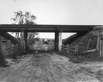
Photograph - Black and white, c. 1920
This image is part of a larger collection of images from the Public Transport Corporation displaying train stations and streetscapes in what is now the City of Kingston.While the focus of this image is the train line running overhead, the unsealed nature of the road speaks to the progression of suburban development during the 1920s.Black and white image of an unsealed underpass at Patterson Road, looking west. A car has stopped on the road in the distance and man is standing on the duckboard leaning into the car.Round white sticker on reverse with black printed text: 177 Handwritten in red ink: 60% Blue ink stamped on reverse: COPYRIGHT / Public Transport Corporation / For re-ordering photographs / Please quote negative No ADV 300 / Enquiries C/- PTC Photographic Unit / Telephone switchboard 619 111patterson road, railway, trains, cars, unsealed roads -
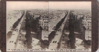 Linton and District Historical Society Inc
Stereograph, The Rose Stereographs, Melbourne, Sydney, Wellington and London, 15,336 The Champs Elysees, Paris, France, Copyright 1912
One of two sets of stereographs donated by the O'Beirne family along with a stereoscope for viewing (Stereoscope is Registration no. 2014-51).Stereograph of two black and white images. Image shows a road running through long rows of buildings. Many horsedrawn vehicles travelling along road.15,336. THE CHAMPS ELYSEES, the Most Fashionable of Parisian Boulevards. Viewed from / the Top of the Arch of Triumph, PARIS, FRANCE.stereographs -
Canterbury History Group
Photograph - Street view of the Bryson Road side of shop No. 92 Maling Road, Jan Pigot, 1994
Coloured photograph of the street view of the Bryson Road side of Buckley's Supermarket, shop No. 92 Maling Road. This is also the corner of the building named The Block 1907.canterbury, maling road, shops, bryson street, buckley family, the block -
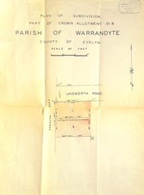 Ringwood and District Historical Society
Document - Plan of Subdivision, Part of Crown Allotment 31B, Parish of Warrandyte, County of Evelyn - (undated, circa 1960s)
Map showing residential allotments numbered 1 and 2 on Through Road and Unsworth Road, Ringwood, Vic., with property dimensions and location of drainage & sewerage easement.H.J. Macey Licensed Surveyor, 36 Nerissa Street, Burwood (Telephone) BX1917. -
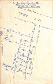 Ringwood and District Historical Society
Map - Subdivision Plan, Part of Crown Allotment 39, Parish of Ringwood, County of Mornington, Heathmont, Victoria - (Undated - circa 1950s)
Hand-drawn map on light cardboard backing showing location and size of 6 allotments on western side of Armstrong Road near Canterbury Road, Heathmont. -
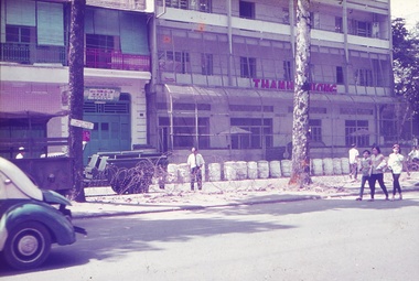 National Vietnam Veterans Museum (NVVM)
Slide - Sims Image Collection
A collection of 253 images on slides taken while on deployment in Vietnam, by Corporal Peter Stanley Sims (44304). Who served in the Royal Australian Army Medical Corps, 1969 - 1970.Looking out from Canberra BEQ (Bachelor and enlisted men's quarters) at buildings and a road with barbed wire between the road and the footpath. Cholon, Vietnam 1969. peter stanley sims, 44304, slides, royal australian army medical corps, vietnam war, sims, cholon, cho lon, canberra beq, bachelor and enlisted men's quarters -
 Whitehorse Historical Society Inc.
Photograph - B/W Photograph, Mullen's House East Burwood
Black and white photograph of the Mullen's family home, built c1960. It was situated at 342 Blackburn Road, East Burwood 2 houses west of Burwood Road.burwood east, mullen's home c1960 -
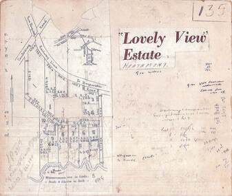 Ringwood and District Historical Society
Map, Plan of Subdivision - Lovely View Estate, Heathmont, Victoria (Undated, circa 1930s)
Photocopied map from land sale brochure with handwritten real estate sales notations. Subdivision includes allotments on Dickason's Road and Allen's Road, Heathmont.LP3917 Part of Crown Allotments 14A-40A Parish of Ringwood. Vol 3232 Fol 626380. -
Whitehorse Historical Society Inc.
Letter - Correspondence, Crabhole Hill, 2016
An email from Ted Arrowsmith querying the name Crabhole Hill, Mitcham.An email from Ted Arrowsmith querying the name Crabhole Hill, Mitcham, which encompasses Whitehorse Road from McDowall Street to Thomas Street as reported in the Whitehorse Historical Society Newsletter, series 24 No.3 May - Jun 2016 from a transcript from the Blackburn & Mitcham Reporter 17 Jun 1932.An email from Ted Arrowsmith querying the name Crabhole Hill, Mitcham. crabhole hill, mitcham, arrowsmith, ted, mcdowall street, mitcham, thomas street, mitcham, whitehorse road, mitcham, blackburn & mitcham reporter, whitehorse historical society inc -
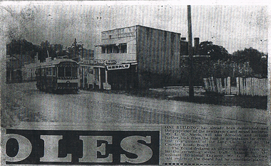 Bendigo Historical Society Inc.
Newspaper - LONG GULLY HISTORY GROUP COLLECTION: EAGLEHAWK ROAD
BHS CollectionPhotocopy of a newspaper article and photo of Eaglehawk Road with a tram outside a two story newsagency. On the right is a dilapidated timber fence. Written on the back is: approx 1966 ? One of the last trams No. 18 to run up Main Street of Long Gully (Bond Street) now known Eaglehawk Road. On Left Post Office - now Gents Hairdresser & Rose of No. 3 Australia Hotel. On right Les & Marie Norris Newsagency & Mixed Business. 2 story Building was Commercial Hotel. No. 26 Tram was the last To Run between Bendigo , Long Gully & Eaglehawk still running as a Tourist tram in Bendigo 1987. Donated by Alan Crossley 1985.bendigo, history, long gully history group, the long gully history group - eaglehawk road, mr l w norris, country roads board, mr g marshallsea, rose of australia hotel, les & marie norris, commercial hotel, alan crossley -
 Ringwood and District Historical Society
Flyer, Land Sale Advertisement and auction notice - Range View Estate, Ringwood, Victoria - 1920
Advertisement for sale of 150 residential allotments with terms of sale, summary of local features and services, and map showing location and layout of subdivision within the boundary of Mitcham to the west of Ringwood, Victoria. Copy of newspaper advertisement (The Herald, Melbourne, Wednesday 3 March, 1920) refers to public auction date for Range View Estate Ringwood - Saturday, 27th March, 1920.Subdivision includes Deep Creek Road, Range View Grove, Warnes Road, Tarrangower Avenue, Prince Edward Avenue, James Avenue, and White Horse Road, Mitcham. Agents - Phillips & Nicholson, 281 Collins Street, Melbourne, Telephone Central 10907. -
 Ringwood and District Historical Society
Plan, Ringwood Station Estate, Subdivision, Ringwood, Victoria - circa 1925
ID 5224 note: Further information relating to squares marked H, F, G, J, and K included in ID 5225 - Ringwood Shop and Dwelling Estate.Hand drawn plan of Ringwood Station Estate showing allotments for sale, with two typed pages attached showing land title information and sale prices.Drawn by Edyth Greenwood, phone 988 Central. Subdivision includes Station Street, Pitt Street, Bedford Road, Wantirna Road, James Street, William Street (later Kendall Street), Greenwood Avenue, Ellison Street, and Haig Street. Circles denote blocks for sale. Squares denote house properties for sale. Other features marked include location of businesses along Main Street (Maroondah Highway), cool store, railway station, shop and police station on Bedford Road, church on Station Street, site of schoolmaster's residence and State School, and location of proposed public baths. Ryner & Langford, Solicitors -
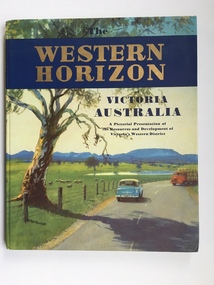 Warrnambool and District Historical Society Inc.
Book, Western Horizon, C 1960
This book presents a pictorial history of the western District of Victoria. It explores various aspects of the Western District such as water supply,architecture,ports,produce,and agriculture. It also presents the various scenic spots around the district. The publishers of this book , the Australian publicity Council is dedicated to publicising the state of Victoria and its natural resources in an effort to attract overseas investment and industry.This book provides a snapshot of the Western District in the 1960 's both with the information and the photographs contained within, including some which were taken by Ralph Illidge who was one on Warrnambool's best known photographers. Coloured hard board cover with country scene with road with two vehicles on a road which continues to the back cover.. A large gum tree sits beside the road. The title is gold on a navy blue banner. Thereis a small blurb on the back cover. 112 pages.Australian Publicity Council. Henry Bolte Premier of Victoria.history of warrnambool, western horizon, western victoria, ralph illidge, warrnambool 1960's -
Port Melbourne Historical & Preservation Society
Plan - Traffic census, Port Melbourne, 6 Mar 1947
Traffic census 6th March 1947 showing intersections at Ingles Street and Williamstown Road (no 84), Lorimer Street and Salmon Street )no 90) Beach Street and Bay Street (no 113) Williamstown Road and Beach Road (no 112), Railway Crossing Graham Street (no 77)engineering - roads streets lanes and footpaths -
 Ballarat Tramway Museum
Photograph - Colour Print/s - set of 4, Carolyn Dean, 6/08/2006 12:00:00 AM
Set of four colour photographs of the trams in the depot building, taken by Carolyn Dean, 6/8/2006. .1 - 661 and 27 on 2 and 3 roads .2 - 14 on 4 road, on jacks .3 - 40 on 4 road, pending lining .4 - dittoOn rear of all photos "6.08.06" and " Photo Carolyn Dean"btm, depot, restoration, tram 661, tram 27, tram 14, tram 40 -
 Kew Historical Society Inc
Photograph - City of Kew steamroller and workers, c. 1960
Tom Bentley (1912-1993) was born in Lancashire (UK). From circa 1951, he was the Overseer/Superintendent of Outdoor Works for Kew City Council. Until his retirement in the 1970s, he was based at the Kew Council Depot, located in the former MTB Horse Tram Depot on the corner of Disraeli and High Streets, Kew. Accompanying the set of twelve photographs is a 12-page illustrated biography of the Bentley and Plumridge families, separately kept in the 'Bentley' subject file.Duplicate black and white positive print photograph of road works in Studley Park Road, Kew, carried out under the supervision of Tom Bentley, Overseer/Superintendent of Outdoor Works for the City of Kew. The photograph shows a Council-owned steamroller used for road construction.city of kew, public works, tom bentley, road works, steamrollers -
 Melbourne Tram Museum
Slide - Set of 21, Colin Rough, 29/04/2003 12:00:00 AM
Set of 21, 35mm Tecnodia white plastic mount slides by Colin Rough of trams in St Kilda Road, near the Arts Centre on 29/4/2003. All in M>Tram livery unless noted otherwise. (Were the D's doing driver training?) .1 - Z3 116, all over advertising for Vodaphone, with the Arts Centre buildings in the background. .2 - Z3 122, University .3 - Z3 122, ditto .4 - Z3 139, East Brighton .5 - Z3 195. Arts Centre .6 - Z3 195, Moreland .7 - B 2066 East Coburg, Route 1 - in PTC livery. .8 - B 2104 - South Melbourne Beach, Route 1 .9 - D1 3501, Malvern Route 5 .10 - ditto, but not in service. .11 - D1 3503, University .12 - D1 3503, no destination, followed by another D. .13 - D1 3506, not in service .14 - ditto .15 - ditto followed by an Z class .16 - D1 3508 in all over advertising for Cold Shot Beer, followed by Z2 101 .17 - ditto .18 - D1 3511 - not in service .19 - ditto .20 - D1 3519 (written on slide), not in service or in a colour scheme. Noted as being new. .21 - dittoOn front written on a label "M>Tram, St Kilda Road, Melbourne 29/4/03" and the tram number.trams, tramways, st kilda rd, m>tram, route 22, arts centre, z3 class, b class, route 1, route 5, tram 116, tram 122, tram 139, tram 195, tram 2066, tram 2104, tram 3501, tram 3503, tram 3505, tram 3506, tram 3508, tram 3511, tram 3519, tram 101, d1 class, z2 class -
 Kew Historical Society Inc
Photograph - Former Kew Police Station : Parking lot, 1996
A civic campaign for new public offices developed in Kew in the 1880s. After much deliberation, the location chosen was the junction of Bulleen and Cotham Roads. The buildings were designed by George Watson and John Henry Harvey, architects within the Department of Public Works (Victoria). Building was commenced in 1887, and after one year, the buildings were opened. The Post Office was transferred to the new Commonwealth Government in 1901. The Police Station and Court House, sold by the Victorian Government to the City of Boroondara in 2007, are now a community cultural centre and performing arts venue.The buildings were listed on the Victorian Heritage Register Register (HO885) in 1991. They are historically and architecturally significant to the State of Victoria because Watson and Harvey's designs exhibit diversity in integrating civil offices, they accommodate the apex of road junctions, and they demonstrate a departure from the contemporaneously favoured High Victorian Classical to the Queen Anne style in the design of civic buildings.View through the old wire gates into the parking lot behind the former Kew Police Station and Court House. This was the entrance from Cotham Road with which supplies, prisoners, and police cars would enter.kew court house, public offices -- kew (vic), kew police station -
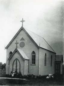 Lakes Entrance Historical Society
Photograph - St Nicholas Church of England Lakes Entrance, 1900 c
St Nicholas Anglican Church, (Church of England) showing timber building with porch at front and vestry at rear. Main building, vestry and porch have high pitched gable roofs with cross apex, window each side of porch, two windows at side of church, upper arched panes open. Two ventilators, one triangular, one circular in wall above porch. About eighteen children seated on ground. Lakes Entrance Victoria. Photo taken of original church site, south corner of Church and Mechanics Streets, before removal and enlargement on north corner of streets.Black and white photograph of St Nicholas Anglican Church, showing timber building with porch at front and vestry at rear. Main building, vestry and porch have high pitched gable roofs with cross apex, window each side of porch, two windows at side of church, upper arched panes open. Two ventilators, one triangular, one circular in wall above porch. About eighteen children seated on ground. Lakes Entrance VictoriaOriginal Church 1898 removed, rededicated 1908religion, buildings, churches -
 Whitehorse Historical Society Inc.
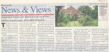
Article, Walker Estate, 22/11/1997 12:00:00 AM
Luther College Year 10 History assignment Residents in Mitcham are fighting to save one of their suburb's historic homes.Residents in Mitcham are fighting to save one of their suburb's historic homes. More than 60 objections have been received by the City of Whitehorse Planning Office to an application by Metrospan Developments to build 16 double storey units at 456 - 460 Mitcham Road, Mitcham. The proposed development is on part of the historic Walker Estate.Luther College Year 10 History assignment Residents in Mitcham are fighting to save one of their suburb's historic homes. walker estate, hogg, tony, australian tesselated tile co. pty ltd, allan, peter, buckingham, helen, rigo, anthony, metrospan developments -
Whitehorse Historical Society Inc.
Article, Alzheimers Hostel strives to provide World Class Care, 1990
Construction of Nunawading's first hostel for dementia sufferers is about to start.Construction of Nunawading's first hostel for dementia sufferers is about to start. Last week a Federal Government Grant of $666,439 was received. Strathdon Lodge in Jolimont Road, Forest Hill, is due to open in 1991. A campaign to raise more than $1.4 million for the development will be officially launched by the Mayor of Nunawading, Cr. Dorothy Smith.Construction of Nunawading's first hostel for dementia sufferers is about to start. nursing homes, aged people, strathdon community, best, bill, smith, dorothy g, trembath, bobbie -
 Sunshine and District Historical Society Incorporated
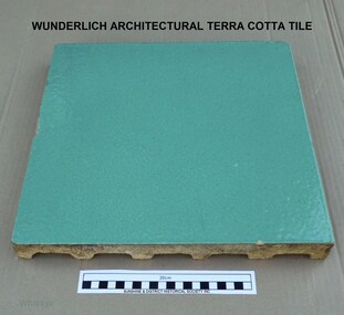
WUNDERLICH TILE, Wunderlich Limited, Circa 1965
In the Sunshine Advocate of 21/03/1925 it is reported that Wunderlich Ltd decided to establish works in Sunshine for the manufacture of terra cotta and faience for the facing of city buildings. The product was intended to imitate granite, which would give a brighter appearance to concrete walls. A stone surface finish to the terra cotta could be achieved by applying a variety of colour combinations of glazes with a special 'spackle' gun. A building that is still standing and has the imitation granite finish terra cotta is the Nicholas Building at 21 - 47 Swanston Street, Melbourne. The Nicholas Building was designed by Harry Norris for Alfred Nicholas (Aspro fame), and was built during 1925 - 1926. The building is classified by the National Trust (B4079) and has the Victorian Heritage Register (H2119). During my employment in the factory from 1964 to 1969 the tiles were generally faced with single colour glazes. For some small jobs a light coloured mottled finish was achieved by spattering a white glaze over a cream coloured background or vice versa. There were no imitation granite jobs done, probably because of changing attitudes to the intended appearance of buildings. The green coloured tile in our collection is an unfinished (untrimmed) retain tile typical of the green coloured tiles that were made for the two stages of the Commonwealth Centre Building (colloquially known as the Green Latrine), that was once located on the corner of Spring and Victoria Streets in Melbourne. Similar coloured tiles were also used on some shop fronts. The Commonwealth Centre Building no longer exists, however the Century Building at 125 - 133 Swanston Street, Melbourne is covered with single coloured tiles (white). The Century Building was built in 1939, with the architect being Marcus Barlow. The Building is classified by the National Trust (B4045). Our tile along with several others were headed for dumping among the asbestos waste at the rear of the two Wunderlich factories (Circa 1968). With permission from the Factory Superintendent of the Terra Cotta factory they were saved and taken home. Several are still in use as pavers around a barbecue in Melton from where our tile was obtained. It should be noted that the Wunderlich Architectural Terra Cotta factory in Sunshine did not manufacture terra cotta roofing tiles, as reported in the Brimbank City Council Post-contact Heritage Study HO 073 former Wunderlich now West End Market. Wunderlich terra cotta roofing tiles were manufactured at their factory in Mitcham Road, Vermont. Document HO 073 contains at least 3 errors. Other References: (1). http://nla.gov.au/nla.news-article74726224. (2). Armstrong, J. 'Investigating the historic and current use, manufacture and conservation of architectural terra cotta and faience USA & UK'. This tile is an example of the type of facing that was applied to city buildings for over 40 years from the mid 1920's. As building techniques changed the need for this type of facing diminished, and so the factory was eventually sold and demolished. A free standing tall chimney stack which serviced two of the kilns was a significant feature of the North Sunshine skyline. A part of the history of Sunshine disappeared with the demolition of the factory and the chimney stack. Only the façade of the finishing section of the factory where tiles were trimmed and stored remains. Off-white/beige architectural terra cotta tile with green coloured vitreous glaze on the face of tile. The rear of tile is ribbed. wunderlich limited, terra cotta, architectural, commonwealth centre, spring street, sunshine, mcintyre, victoria street, faience, faence, imitation granite, nicholas building, century building -
 Melbourne Tram Museum
Document - Personal Papers, Jack McLean, Keith Kings, "Tramway / Railway level crossings", 1954
Set pf personal papers concerning tramway / railway level crossings in Melbourne. Consist of .1 - letter to Ross dated 19/3/1984, carbon copy from Jack McLean, printed on computer paper perforated computer paper torn into strips - has hand written notes. Three separate sheets. Covers Market St Melbourne (Queensbridge) South Melbourne (City Road) St George Road - North Fitzroy Queens Parade Clifton Hill Epsom Road Showgrounds Glenferrie Road Hawthorn Glenferrie Road Malvern Burke Road Camberwell, Glenferrie Rd Kooyong, Burke Road Gardiner Glenhuntly Road Glenhuntly Glenhuntly Road Elsternwick, Whitehorse Road (Deepdene), Riversdale Road, Riversdale Lygon St North Carlton Nicholson St Footscray Nicholson St North Fitzroy, .2 - six pages - retype of above document on A4 computer printing paper - covers the same material. .3 - Hand drawing of the Melbourne rail system with crossing dates including bridges noted on it for cable and electric tramways. Has initials KK 12/54 in bottom right hand corner. drawn on lined double width foolscap paper.trams, tramways, level crossings, railway squares, tramway square, cable trams -
 Southern Sherbrooke Historical Society Inc.
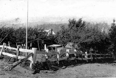
Photograph - Tantallon, Douglas farm at Menzies Creek/Emerald
Black and White photograph of 'Tantallon', the Menzies Creek/Emerald Farm owned by Norah and Percy Douglas, situated on the north side of Ridge Road. The photo shows a corner of a post and rail fence enclosing a small farm paddock. Behind a row of trees, a brick chimney and part of a roof can be seen, presumably the main farmhouse. Timbered hills can be seen in the background. The photo appears to be taken looking north. See also VSSH0046 for more details. -
 Whitehorse Historical Society Inc.
Pamphlet, Artist's Camp, 1987
Pamphlet on Box Hill Artists CampPamphlet on Box Hill Artists Camp and the move to Eaglemont, near Heidelberg when the term Heidelberg School began to be used, in 1988. The Box Hill Camp was made on David Houston's property on Gardiners Creek, south of Canterbury Road, between the present sites of Bowater Scott and Box Hill Golf Club.Pamphlet on Box Hill Artists Camp artists camps, roberts, tom, mccubbin, frederick, streeton, arthur, conder, charles, abrahams, louis, houston, david, gardiners creek