Showing 4145 items matching " however"
-
 Flagstaff Hill Maritime Museum and Village
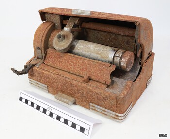
Machine - Voice Recorder, Thomas A. Edison, Edison Laboratory, 1916-1929
This Edison Ediphone voice recording electronic business machine is manufactured to suit a small office and is light enough to carry between work and home for use outside normal business hours. It is a dictation machine, also called by the competitor’s brand name ‘Dictaphone’, and is used for recording spoken words that would later be transcribed and typewritten. A wax cylinder would be installed onto the machine’s drum and the Reproducer on the machine would be lowered onto the cylinder. The user would speak a message into a microphone and the reproducer would then convert the sounds to scribed marks on the cylinder. Later, the cylinder could be played and the Reproducer would enable the sound to be amplified through an attached speaker. This machine is currently without its power cord, microphone and speaker horn. Thomas A. Edison extended the technology of the telegraph to his phonograph machine, invented in the late 19th century. It could record and play back sounds of music and voice on a manually operated mechanical machine that used wax cylinders to store the sound. He envisaged the way this technology could be an asset in the office, and he was right! However, most of his phonograph machines were used for entertainment, some for playing lessons, and some for-teaching languages. In 1916 Edison introduced the Ediphone, which grew in popularity after the First World War and into the late 1920s until flat round records replaced the wax cylinders. This Edison Ediphone is significant for improving the way business administration was carried out in the early 20th century, freeing up precious time for professionals and administrative personnel. It was the forerunner of audio tapes and digital technology. The Ediphone enabled letters to be dictated when the time and place suited and reduced the time professionals needed to spend with their secretaries. Secretaries were able to type the letters as they played the recording and they could replay the message if necessary.Voice recorder; a dictation machine; desktop model Edison Ediphone. The electronic machine is in a medal case with remnants of the original grey colour. It has a rectangular base with an A4-sized footprint and a domed hood that retracts halfway into the back of the base. The corners of the base have metal reinforcing, and a short metal bar is on the front centre edge of the lid and the base. A long metal drum is mounted inside the machine. A round device called a ‘reproducer’ is mounted above the drum. There is a folding handle on the left front of the machine and an angled stand with paper guides in front of the drum. A rear cover has the maker’s name stamped on it. An electrical socket with eight pins is recessed beside the cover. Made by Edison.In white letters; “EDISON”flagstaff hill, warrnambool, maritime village, maritime museum, shipwreck coast, great ocean road, edison, ediphone, dictating machine, office equipment, voice recorder, usa, dictation, communication, office machine, dictaphone, speaking phonograph, thomas edison, ediphone voicewriter, voice writer -
 Australian Gliding Museum
Machine - Glider - Sailplane
The Schreder HP 14V is an all metal single seat sailplane designed by Richard Schreder in America. The design is an evolution of Schreder’s metal sailplane designs that date from the late 1950s. Schreder won the United States National Soaring Championship in 1966 in the prototype HP 14. He marketed the glider in kit form in the 1960s and 1970s and allowed Slingsby in the UK to further develop the design for production. Schreder HP14 V, registered as VH-GGB, was built in South Australia by Harry Bache of the Waikerie Gliding Club in the 1970s. Martin Simons, an authority on vintage sailplanes (including Slingsby types), refers to this airframe as “built entirely from scratch”. After Bache, this Schreder HP14V passed on to E.G. Moore and N.L. Lovell at Ararat in Western Victoria, then Graeme Rickert of the Canberra Gliding Club and finally, to Greg O’Sullivan of the Geelong Gliding Club. The glider was first flown on 20 December 1975. It appears to have been flown regularly over its life to 2015 and the cumulative use being 1386 hours flown from 702 launches. The log book does not disclose details of flights except as aggregates of flights and times. Details of notable flights by Bache and Moore et al are not available. However, reports from Rickert and O’Sullivan indicate that a good number of cross-country flights of 300km or longer were achieved in this aircraft. A well-engineered metal sailplane from the 1970s with good soaring performance which was designed for amateur construction. All metal single seat glider sailplane with a distinctive V-tail, finished in a white and blue colour schemeRegistration letters 'GGB' on sides of fuselageaustralian gliding, glider, sailplane, schreder, slingsby, bache, waikerie gliding club, moore, lovell, rickert, o’sullivan, canberra gliding club, geelong gliding club. -
 Sunshine and District Historical Society Incorporated
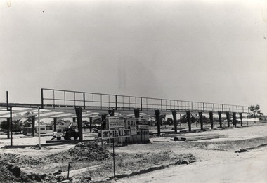
Photographs (1928), 'QUARTER MILE' BRIDGE Construction, 1928
One man lost his life during the building of this bridge. The bridge was constructed by the Victorian Railways between 1927 to 1929 to carry a new double track goods line. This enabled trains from all parts of the state except Gippsland to have direct access to the Tottenham marshalling and sorting yards. These yards were constructed in the 1920's to relieve congestion in the Melbourne Yard near Spencer Street station. The congestion was being caused by the construction of suburban passenger platforms associated with the electrification of the suburban railway network. Initially the bridge was for goods trains but during the Second World War it was also used by troop trains. When the standard gauge line was built in 1962 all trains to Albury and Sydney have used this route, thus avoiding travelling through Essendon and Pascoe Vale on the suburban tracks. The standard gauge track across the bridge took the place of one of the broad gauge tracks so broad gauge trains crossing the bridge in either direction have to now use the same track. The bridge is 1,257 feet (383.13 metres) long and 180 feet (54.86 metres) above the water level. It is just 63 feet (19.2 metres) short of a quarter mile in length between abutments. There is a similar bridge on the same railway line crossing the Moonee Ponds Creek between Gowenbrae and Glenroy, however it is smaller at 1060 feet (323.08 metres) length and 115 feet (35.05) height.The bridge is now Victorian Heritage Registered under Number: H1197, and Heritage Overlay Numbers HO5, and HO107. On the Heritage Register it is named RAIL BRIDGE (ALBION VIADUCT). According to the Heritage Report the bridge is scientifically and architecturally important because of its large size, and because of the cost effective design features such as two girders per span (one for each track), the K bracing in the towers, and the broad flange beams as columns. When it was being built it was the largest trestle bridge in Australia, and until the Sydney Harbour bridge was constructed it was the highest railway bridge.Five B&W yellowing photos showing stages of construction of the Maribyrnong River Viaduct known as the Trestle Bridge but mainly known locally as the QUARTER MILE BRIDGE. It is a railway only bridge which runs over the Maribyrnong River between Sunshine North and Keilor East. A sixth image, which is not part of this set of photos, is included to show what the completed bridge looks like. -
 Yarrawonga and Mulwala Pioneer Museum
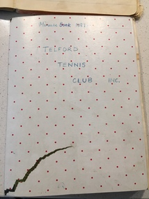
Telford Tennis Club minute books and records, 1920's to 2019
Telford Tennis courts were situated on the Telford Yarrawonga Road, west of the railway line, Telford station and silos. A thriving club existed from early 1920's with players from surrounding areas in early times. balls and tournaments were held as fundraisers. Prominent family names included Stevenson, Chappell, Mulquiney, Thom, Inchbold, Connell. Quinn. There were three teams during the 1960's playing in the Wilby and District Tennis Association ( WDTA) competition. Opponents included Wilby, Almonds, St Mary's, Bundalong, Savernake, Rennie, Roseneath, Burramine. Being in a low lying area the Telford dirt courts were often flooded. At the beginning of the season working bees were held to remove the weeds. mow the surrounds and line the courts During the early 1980's the courts were abandoned and home matches were played at the Yarrawonga Lawn Tennis courts. The club still has a team in the WDTA in 2019. A number of B grade Premierships have been won over the years however A grade premierships have been non existent. The club has always encouraged juniors to play and now the players mostly originate from Yarrawonga. Current President (2019) is Richard Inchbold, Secretary/Treasurer Joan Thom. The Bank account is held at the CMCU. The club is no longer IncorporatedCountry tennis teams provided a social outlet from the farming pursuits of the districtall enclosed in a cardboard box. Minute books 1927 to 2014 (not all complete). Includes photos, paper cuttings, Wilby and District Tennis Association draws, subs books, list of names of those who have played for Telford. Consumer Affairs returns, Incorporation papers, receipt books, some correspondence (later years)see photos -
 Queenscliffe Maritime Museum
Domestic object - China crockery recovered from wreck of Light of the age
Subsequent to the wrecking of the Light of the Age marine concretions and corrosion products formed a cement capping over the cargo, stabilising and protecting it. The site of the Light of the Age was found by divers in late 1960s, and soon became a popular diving site. Huge amounts of intact crockery were removed from the wreck by boatloads of divers, including distinctive brown glazed teapots with legs (one diving author named it 'the Teapot Wreck' (Denmead, 1973: 78-82), 'Greek Key' patterned transferware, Cooper & Wood Portobello black glass three piece bottles, and sauce, preserve and condiment bottles often with contents (gooseberries, raspberries, olives) and seals intact. Larger items including a signal cannon and an anchor were removed from the site, while divers seeking souvenirs commonly used cold chisels to chip objects free of the concretion 'cap' which had stabilised and protected the remaining cargo for so long. In 1982 this situation was drastically changed when someone used explosives to further break concretions. However the charge was too powerful resulting in the site's complete destruction and the remaining items to become scattered and broken. Abraded and worn ceramic objects washed up on the beach are invariably collected by beachgoers, including fragments of crockery, figurines and animal figures used for 19th century household decoration and toys. The Light of the Age is archaeologically significant as the wreck of an international immigrant ship with an inward bound cargo. It is historically significant for its association with both the Black Ball and White Star Lines which carried thousands of immigrants to Australia. Built in 1855 and lost on 16 January 1868 now lies at Point Lonsdale Beach, half a mile west from Point Lonsdale, Port Phillip Heads.01- 1 shallow bowl, 02- 1 sweet bowl, 03- 1 willow pattern service dish, 04- 2 ladle cups [no handles], 05 06- 2 egg cups, 07- 2 bread and butter plates, 08- 1 condiment bowl lidWedgwood deep saucer; Pearl stone china, Ribbon, Wedgewood Willow Pattern service dish, Staffordshire Stone China, Fenton, No10shipwrecks, salvage, crockery, light of the age, clippers -
 Kew Historical Society Inc
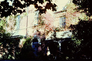
Slide - Residences, 99 Princess Street, 1 Fellows Street, 1979
One of a group of slides taken by members of the Society of built heritage in Kew in 1979-80. The selection of subject matter reflects the priorities of the period. The colour of some slides has degraded. 99 Princes sStreet (1 Fellows Street) was built by the architects Oakden, Addison and Kemp. The Kew Conservation Study (1988) noted that: Erected By Bennie And Olivers, these Two Attached Houses Attracted An Initial Construction N.A.V. of £260. The houses were originally owned and occupied by the architect Henry Kemp, however Kemp appears not to have lived there long because, while he retained ownership for at least a decade, by 1891 George Martin, merchant and bank manager, was recorded as the tenant of No.1 Fellows Street. At that date the N.A.V. for this individual building was £83 and Kemp remained the owner of both properties until at least 1910. Kemp had arrived in Australia in 1886 and this was therefore one of the first of the many buildings he was to design in Melbourne. While late Victorian in date, the houses are of a unified design that is an interesting precursor of the Edwardian architecture produced by Kemp. Somewhat awkwardly composed with steep gables, a rectangular castellated tower and slated single storeyed verandahs projecting from the overall boxlike form, the house contains features common to the 1880s such as the use of polychromy in the brickwork and slates cladding the roof. The building departs from the norm of the time with the use of terracotta tile ridge cappings, and strapwork to the corbelled chimneys.The slides represent a snapshot in time of built architecture in Kew, much of which has changed in the forty-plus period since they were created.Colour positive transparency (slide) of the pair of residences on the corner of Princess Street and Fellows Street in Kew. The point of view is the Fellows Street frontage.comaques, historic houses -- kew (vic.), glenferrie road -- kew (vic.) -
 Kew Historical Society Inc
Photograph - Verandah of 'Wimba', 235 Cotham Road, John T Collins, 1979
Although probably built some time earlier, the first mention in the Rate Books of the property later known as 'Wimba Lodge' appears in the entry for 1870 when the property, owned by John Sharpe Denbigh, a civil servant, was given an N.A.V. of £72. Denbigh did however occupy a house in Cotham Road in 1863, and it is possible that was the same premises'. The house was occupied by Sharp until at least May 1876 when the 'family residence ... was auctioned' to Carlington George Edmund Marston, a chemist of Smith Street, Collingwood. At the time of the auction the house was described thus: The residence and grounds of the late J.S. Dendigh, situate in the most elevated part of Cotham Road Kew. The grounds comprise an area of 4a Or 29p or thereabouts, and have a frontage to Cotham-road of 4 chains. The house has two large rooms in front, with 6ft hall built of brick, bay and side windows (plate glass), four rooms of wood behind with slate roofs, bathroom and closets, detached kitchen and servant's room, large shed with washing boiler, pantry and cellar under, brick and cement tank, and the Yan Yean laid onto house and grounds, cowshed, pigstye, &c, the whole securely fenced. First class orchard and flower garden. The paddocks laid with English grasses and drained... .' (Sanderson P. Kew Conservation Study Vol 2)'Wimba' is a single storeyed rendered house. The front entrance is flanked by two polygonal bay windows, and a verandah with a concave corrugated iron roof returns around three facades, and accentuates the projections of the windows. The solid render parapet is very ornate and tall for the date of construction. It has panels of decoration along it and is surmounted by a number of render urns. (Sanderson P. Kew Conservation Study Vol 2)Reverse: "JOHN COLLINS / 11 Anderson Road / Hawthorn East, 3123 / Film 395 Exposure 15A / Kew / Wimba / Front verandah from east / 7-4-79wimba lodge, 235 cotham road -- kew (vic.), john s denbigh, carlington george edmund marston -
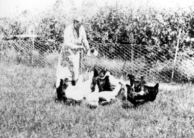 Surrey Hills Historical Society Collection
Photograph, Mrs Jessie Crow feeding fowls
The property is identified as 'Strathmore', the home of Joseph Sutton Crow and his wife Winifred (Jessie) Temby, whom he married in 1910. Joseph Sutton Crow: (1881-1969) - Joseph Sutton Crow gained his Diploma of Music from the Marshall Hall Conservatorium, the forerunner to the Melbourne University Conservatorium, in 1907. He taught both piano and organ and was organist and choirmaster in several churches. However it was as a fine administrator that Sutton Crow made a significant contribution to music in Melbourne. From 1910-1920 he was Secretary and Librarian of the Music Department at the University of Melbourne and from 1920 was the Secretary and Assistant Director of the Conservatorium of Music. From 1919 he was also Secretary of the Australian Music Examinations Board. He married lyric soprano, Jessie Temby and moved to ‘Strathmore’, 75 Victoria Crescent, Mont Albert in 1924 and lived there until 1952. In c1926 he was one of those behind establishing the public appeal to raise a million shillings to go towards the establishment of a permanent Symphony Orchestra. The appeal successfully raised both £4000 and the profile of orchestral music in Melbourne. The result was the Melbourne University Symphony Orchestra, which later became the Melbourne Symphony Orchestra, and from 1926-1939 he was its manager. Close local musical contemporaries were violinist Stanislau de Tarczynski and pianist Edward Goll, both of whom lived in Mont Albert. Winifred Jessie Temby (1883 - 1968) - soprano The donor was their daughter.A black and white photograph of a lady holding a sauce pan in her left hand and ladling out food to the fowls in front of her. Behind her there is a fenced off area with trees behind it.'strathmore', house names, victoria crescent, mont albert, surrey hills, joseph sutton crow (mr), winifred jessie temby (miss), jessie tremby (miss), winifred jessie crow (mrs), jessie crow (mrs), orchards, jean crow (miss) -
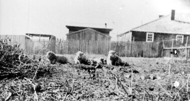 Surrey Hills Historical Society Collection
Photograph, Backyard of 'Strathmore', 75 Victoria Crescent, early 20th century
The property is identified as 'Strathmore', the home of Joseph Sutton Crow and his wife Winifred (Jessie) Temby, whom he married in 1910. Joseph Sutton Crow: (1881-1969) - Joseph Sutton Crow gained his Diploma of Music from the Marshall Hall Conservatorium, the forerunner to the Melbourne University Conservatorium, in 1907. He taught both piano and organ and was organist and choirmaster in several churches. However it was as a fine administrator that Sutton Crow made a significant contribution to music in Melbourne. From 1910-1920 he was Secretary and Librarian of the Music Department at the University of Melbourne and from 1920 was the Secretary and Assistant Director of the Conservatorium of Music. From 1919 he was also Secretary of the Australian Music Examinations Board. He married lyric soprano, Jessie Temby and moved to ‘Strathmore’, 75 Victoria Crescent, Mont Albert in 1924 and lived there until 1952. In c1926 he was one of those behind establishing the public appeal to raise a million shillings to go towards the establishment of a permanent Symphony Orchestra. The appeal successfully raised both £4000 and the profile of orchestral music in Melbourne. The result was the Melbourne University Symphony Orchestra, which later became the Melbourne Symphony Orchestra, and from 1926-1939 he was its manager. Close local musical contemporaries were violinist Stanislau de Tarczynski and pianist Edward Goll, both of whom lived in Mont Albert. Winifred Jessie Temby (1883 - 1968) - soprano A black and white photograph of three sheep lying in the grounds of a house. There is a house and some sheds in the background behind a picket fence.'strathmore', house names, victoria crescent, mont albert, surrey hills, joseph sutton crow (mr), winifred jessie crow (mrs), jessie crow (mrs), jessie temby (miss), winifred jessie temby (miss), orchards, music -
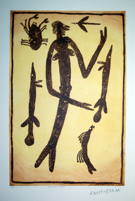 Federation University Art Collection
Work on paper - Artwork - printmaking, Lytlewode Press, A suite of limited edition prints by Paddy Fordham Wainburranga, 2003, 2003
Paddy Fordham Wainburranga (1932-2006) Area: Arnhem Land Country: Bamdibu (Bumdubu) near Bulman Station As a child, Paddy grew up in Maningrida an Aboriginal community on the top end of the Northern Territory. He started working as a boy around cattle yards, which finally led him to working as a stockman for 20 years. Before this, he spent much of his time hunting and learning culture and customs from his father and uncles. He could remember being taken to a sacred location where he was told many Dreamtime stories of how customs came to be and why Aboriginal people practice them. Paddy was part of the movement for equal rights for all Aborigines, actively involved in claiming Bumdibu as his traditional land for his clan. He resided over this land as Jungai (caretaker, policeman). Paddy was taught to paint by his father but did not begin to paint seriously until the early 1970s. He was also recognized as a story teller, bark painter, sculpture, dancer, singer and musician. He was familiar with Central Arnhem Land rock and bark painting traditions; however he developed an idiosyncratic style which fused the figurative schema of western Arnhem Land with the narrative capacities of the north-east producing dense pictorial paintings divided into sequential segments. A suite of seven limited edition prints using the sugar lift aquatint technique. .1) Yalk Yalk Woman Sugar Lift Aquatint Plate 75.0cm (H) x 49.0cm (W) Paper 1110cm (H) x 76.0cm (W) 2003 Edition: 73/100 .2) Walga Walga Sugar Lift Aquatint Plate 75.0cm (H) x 49.0cm (W) Paper 1110cm (H) x 76.0cm (W) 2003 Edition: 73/100 .3) Nammooroddoo Sugar Lift Aquatint Plate 75.0cm (H) x 49.0cm (W) Paper 1110cm (H) x 76.0cm (W) 2003 Edition: 73/100 Nammooroddoo Sugar Lift Aquatint Plate 75.0cm (H) x 49.0cm (W) Paper 1110cm (H) x 76.0cm (W) 2003 Edition: 73/100 .3) Nammooroddoo Sugar Lift Aquatint Plate 75.0cm (H) x 49.0cm (W) Paper 1110cm (H) x 76.0cm (W) 2003 Edition: 73/100 .4) Mun Gruk Gruk Woman Sugar Lift Aquatint Plate 75.0cm (H) x 49.0cm (W) Paper 1110cm (H) x 76.0cm (W) 2003 Edition: 73/100 .5 Mun Gruk Gruk Man Sugar Lift Aquatint Plate 75.0cm (H) x 49.0cm (W) Paper 1110cm (H) x 76.0cm (W) 2003 Edition: 73/100 .6) Mun Gruk Gruk Sugar Lift Aquatint Plate 75.0cm (H) x 49.0cm (W) Paper 1110cm (H) x 76.0cm (W) 2003 Edition: 73/100 .7) Lightning Man Sugar Lift Aquatint Plate 75.0cm (H) x 49.0cm (W) Paper 1110cm (H) x 76.0cm (W) 2003 Edition: 73/100 Donated through the Australian Government Cultural Gifts Programme by Katherine N. Littlewood, 2014artist, artwork, paddy fordham wainburranga, paddy fordham, wainburranga, printmaking, aboriginal, indigenous, churchill, dreaming -
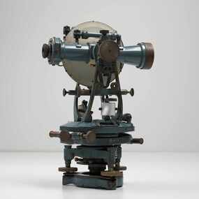 City of Greater Bendigo - Civic Collection
Instrument - Theodolite, Cooke, Troughton & Simms, c 1940
Theodolites are a highly accurate instrument that measures angles between designated visible points in the horizontal and vertical planes. The theodolite has a long history, with the term first found in 1571 in a surveying textbook 'A geometric practice named Pantometria' by Leonard Digges. (source https://en.wikipedia.org/wiki/Theodolite). Cooke Troughton & Simms began when John Troughton starting selling products in Fleet Street, London in 1782. He went into partnership with his brother Edward in 1807 who expanded the business considerably. William Simms, a former apprentice with the company was taken as a partner and then manager after Edward died in 1835 and the company became Troughton & Simms. By 1887 the company was able to produce all the parts necessary for their instruments and the company employed nearly 200 people and was one of the most well respected firms of instrument makers of the 1800's. James Simms, son of William who had inherited the company died in 1915 and the company was turned into a limited liability company by his two sons William and James. Things however were not so easy for the two sons and in 1922 the business was brought out by their rival T. Cooke & Sons becoming Cooke, Troughton & Simms. Theodolites are used by surveyors as part of their everyday work and although there is no specific information regarding the provenance of this particular one it is assumed it was used locally by the City of Bendigo and / or the Lands Department.A grey theodolite no 39161 made by Cooke, Thoughton & Simms. Various moving parts showing signs of extensive use particularly on the uprights on the main body and around knobs and dials where the paint is worn back to brass.Cooke, Thoughton & Simms Ltd / York. England / No 39161. Sticker; DPS - Asset No / (barcode) / 0010173city of greater bendigo administration item, lands and survey department bendigo -
 Wodonga & District Historical Society Inc
Photograph - Mann Collection Album - Sanyo, Kendall Street and Chapple Streets, Wodonga, 1974
This photo is from a collection donated by Elaine Mann. Elaine Mann was married to David Mann, a successful Wodonga businessman and community leader who passed away in Wodonga in June 2012. David was a member of the Mann family who began their business in Wodonga in 1920. Elaine was a teacher in Wodonga for many years and an active member of the community. Sanyo was one of the international companies that set up business in Wodonga in the 1970s as part of the decentralisation of industry. The Sanyo Australia Pty. Ltd. factory in Wodonga was officially opened on 25 October 1974 with 35 staff and production peaked in 1976-1977 when it employed 360 people. In the first ten years, 350,000 televisions were assembled from Japanese parts. The official plaque was uncovered by Victorian Premier Rupert Hamer. In October 1977 there were 79 workers retrenched, followed by 30 in November and 45 in February 1978. In 1978 workers staged a sit-in which lasted over a week, to protest multiple mass retrenchments of staff. The factory stayed open for almost another decade. In 1982 the General Manager of Sanyo was quoted as saying the productivity in the Wodonga factory was 10% higher than in Japan. However by 1984 the number of staff had reduced to 112 and the factory closed in 1987. The premises were taken over by Parker Hannifin. The administration building is now the home of 3D Lanes Bowling Alley. The street in which it is located is now called Sanyo Drive.This photo collection is of significance as it documents how the businesses and buildings in Wodonga have evolved and contributed to community throughout the late 20th century.Sanyo Factory construction. A $1 million factory built in Wodonga to assemble 300,000 colour-television sets in readiness for the introduction of colour TV in Australia on March 1, 1975. The building is now occupied by Parker Hannifin and also Wodonga Ten Pin Bowls.wodonga businesses, high st wodonga, sanyo -
 Trafalgar Holden Museum
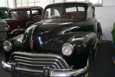
Vehicle - 1946 Oldsmobile, 1942
General Motors Holden imported this vehicle into Australia from Canada in approximately 1941 or 1942 as 4 door sedan. The Oldsmobile company believed that at the end of WW2 there would be a need for coupes worldwide. GMH at that time were heavily committed to he war effort and the proposal was to convert this vehicle into a coupe in line for Coup with the Oldsmobile policy. The conversion went ahead under some secrecy as the war effort had priority. The result was by the end of war this coupe was manufactured at the GMH Fisherman's Bend plant. The car was taken to both Brisbane and Sydney motor shows and was immediately a success with GMH taking orders at both shows. However when these orders were forwarded to Oldsmobile USA the response was less than favourable. Apparently Oldsmobile had been inundated with orders for Coupes in both Canada and the USA and could not fullfill any overseas orders due to lack of capacity. This vehicle under instructions from USA was to be hidden and not used for sales promotion anywhere in Australia. The exact location of this vehicle is somewhat lost between 1946 and 1990's. It was located in Kyneton in Victoria where it had been placed in the back of Kyneton GMH dealership. It was extracted by Doug___ from Warrandyte, removed from the blackberries and undergrowth and taken for restoration. Progress was slow and it was sold to the museum fully restored by Mr Rob Treen Glassy Spur Victoria. The colours both interior and exterior are the same as it came out of the GMH workshop in 1945.It is a one off vehicle and the only 2 door RHD Oldsmobile Coupe body made by Holden.1946 Black Oldsmobile 2 door automobile, 1932, car -
 The Beechworth Burke Museum
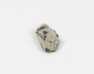
Geological specimen - Chalcopyrite
This specimen was recovered from Mica Schist, Canada. Chalcopyrite is a copper iron sulfide mineral with a chemical composition of CuFeS2. Its name derives from the Greek words for copper (chalco-) and brass (pyrite). It can be found in shades of yellow, green and grey, and, when exposed to acid, it can change to purple, blue, violet and yellow tones. Weathering can cause loss of its metallic luster and its brass-yellow colour. Chalcopyrite forms under various conditions, with the most significant deposits being hydrothermal in their origin. It is known globally as the most important ore of copper for thousands of years, and is thus considered a very important mineral formation. Given its golden appearance, it is often confused for the mineral gold, earning it the popular reputation as 'fool's gold' or 'yellow copper'. However, it can be straightforwardly distinguished from gold; the latter is soft, with higher specific gravity and a yellow streak, whereas chalcopyrite is brittle, easily scratched by a nail, and has a greenish grey streak. Copper was the first metal that was used by people. It was discovered by the Neolithic man about 9,000 years ago and it gradually replaced stone as it was easier to be shaped. In Australia, search for copper began after the European settlement, leading to the discovery of substantial deposits, like the one at the Olympic Dam in South Australia, which is regarded as one of the largest copper deposits in the world. Chalcopyrite has been used for copper since smelting processes began approximately five thousand years ago. Although by no means rare, this the specimen of this mineral can be used to reflect a wider history of industrial uses of copper for a significant portion of human history. This specimen is part of a larger collection of geological and mineral specimens collected from around Australia (and some parts of the world) and donated to the Burke Museum between 1868-1880. A large percentage of these specimens were collected in Victoria as part of the Geological Survey of Victoria that begun in 1852 (in response to the Gold Rush) to study and map the geology of Victoria. Collecting geological specimens was an important part of mapping and understanding the scientific makeup of the earth. Many of these specimens were sent to research and collecting organisations across Australia, including the Burke Museum, to educate and encourage further study.A solid hand-sized copper iron sulfide mineral of brass yellow, often with an iridescent tarnish, with greenish-black streak and submetallic luster. Chalcopyrite can be formed in several ways, including crystalizing from accessory minerals in igneous rocks, or from magma or within volcano sulfide deposits. Most commonly, chalcopyrite are found in hydrothermal conditions, where it forms in hydrothermal veins. As a member of the tetragonal crystal system, it often takes the shape of tetra-headed crystals, often with striations along the sides of the crystals. #18 Copper pyrites/(chalcopyrite) in/Laurentian Slate/(page 315 of inventory)/page missing from/descriptive catalogue/ Other label: 81 /fool's gold, chalcopyrite, mineral, rock, geology, geological, hydrothermal, neolithic, european settlement, olympic dam, south australia, stone, deposits, specific gravity, greenish grey streak, brittle, mineral gold, metallic luster, cufes2, greek words -
 Flagstaff Hill Maritime Museum and Village
Textile - Man's vest, 1916
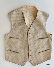
This cream and green patterned vest is said to have been made for William Herbert Teal as part of his "trouseau" on the occasion of his marriage to Daisy Edith Davis on April 14th 1916 at St. Peter's Church, Merino, Victoria, Australia. It is a handmade waistcoat but it is not known who made it. William Teal was born in 1889 to Elijah Teal and Isabella Campbell Reid in Camperdown, Victoria and after marrying, William and Daisy also lived (and worked as farmers) in the Camperdown area. They had seven children. Daisy died in 1962 and William died in 1975. A wedding portrait of William and Daisy shows William wearing a dark suit consisting of a single breasted coat, trousers, good shoes, gloves and a shirt with a stiff, high collar, however if he is wearing this vest, it is unfortunately hidden under his coat. Although by 1916, men's "ready to wear" clothing were widely available, this waistcoat was handmade (possibly by his mother or sister or future wife) and has been preserved by his family for almost one hundred years. Men's suits in the early part of the twentieth century were predomininantly three piece, consisting of a jacket, vest ( or waistcoat) and trousers made from matching fabrics. On special occasions (such as a marriage) the groom might also wear gloves and have a flower in his buttonhole. Some men liked to wear a watch attached to their waistcoat with a fob chain.This item is of significance as a rare example of a man's vest that was made for a special occasion (William Teal's marriage in 1916) and preserved by his family for several generations.Man's handmade vest with a green and cream patterned brocade front, trimmed with green cord around the edges and featuring four inset pockets (also trimmed with the green cord). It has six buttonholes down the left front edge (plus a hand embroidered buttonhole to hold a fob chain) and six corresponding holes for shank buttons (which are missing) down the right front edge. The back and lining are made from cream cotton fabric. The back has a centre seam and a strap with a metal buckle with prongs (to allow for adjusting the length). The cream lining and back display some discolouration and brown marks.flagstaff hill maritime museum and village, great ocean road, warrnambool, camperdown, merino, teal family, william herbert teal, daisy teal, daisy davis, waistcoat, man's waistcoat, vest, wedding, handmade vest, wedding clothes -
 City of Moorabbin Historical Society (Operating the Box Cottage Museum)
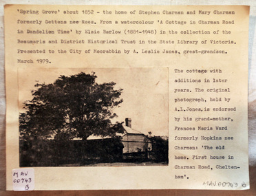
Document - Photograph, photocopy, of ‘Spring Grove’ 19th C house, Charman Road, Cheltenham, c1979
In 1852 Stephen Charman purchased 160 acres bounded by Charman Rd and Balcombe Road in an area called Spring Grove , later Cheltenham. A spring ran through the land providing a good source of water. Stephen aged 21 years had arrived in Melbourne 1842 as one of Henry Dendy’s emigrants . His Ship passage was paid by the Colonial Land and Emigration Commission and in return he was required to work on the land of the Henry Dendy Special Survey Brighton 1841. However Henry Dendy could not provide enough work for all the emigrants that arrived and Stephen had to obtain other work. Then sadly his young wife Harriett and their infant died. 1850 Stephen married widow Mary Gettens, a Publican in Little Collins Street, with 5 children. Stephen & Mary built a wattle and daub hut and established a market garden producing marigolds for Martin & Pleasance Pharmacists, Melbourne. They had 7 more children and built a weatherboard cottage that was used for early Methodist Church services. Stephen donated 1 acre to the Methodist Church in 1855 for Chapel , School and Cemetery. This is the weatherboard cottage in the photocopy showing the building extension, The road between Cheltenham and Mentone bears their name. Mary died in 1870 and Stephen remarried 1878 and died in Gippsland 1906. The original Photograph is endorsed by Francis Marie Ward , formerly Hopkins nee Charman who was the grandmother of Mr A.L Jones A photocopy of a black and white photograph of ‘Spring Grove’ , that was the first house in Charman Road , Cheltenham c1852 , showing later extensions. spring grove cottage 1852, schumer l, cheltenham, charman stephen, early settlers, jones a l, gettens mary, rees mary, charman mary, moorabbin, brighton, henry dendy special survey 1841, ward frances marie, charman frances marie -
 Federation University Historical Collection
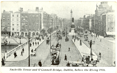
Postcard - Postcards - black and white, Coleman & Co, Dublin before and after the Rising, 1916, c1916
The Easter Uprising took place in April 1916 in Dublin and is one of the pivotal events in modern Irish history. At the end of the Easter Uprising, 15 men identified as leaders were executed at Kilmainham Jail. To some, these men were traitors, to others they became heroes. (http://www.historylearningsite.co.uk/1916_easter_rising.htm, accessed 16 April 2014) Organised by seven members of the Military Council of the Irish Republican Brotherhood,[3] the Rising began on Easter Monday, 24 April 1916, and lasted for six days. Members of the Irish Volunteers — led by schoolmaster and Irish language activist Patrick Pearse, joined by the smaller Irish Citizen Army of James Connolly, along with 200 members of Cumann na mBan — seized key locations in Dublin and proclaimed the Irish Republic independent of the United Kingdom. There were some actions in other parts of Ireland: however, except for the attack on the Royal Irish Constabulary barracks at Ashbourne, County Meath, they were minor. With vastly superior numbers and the use of artillery, the British army quickly suppressed the Rising, and Pearse agreed to an unconditional surrender on Saturday 29 April. Most of the leaders were executed following courts-martial, but the Rising succeeded in bringing physical force republicanism back to the forefront of Irish politics. (http://en.wikipedia.org/wiki/Easter_Rising, accessed 16/04/2014) Sackville Street Dublin is now known a O'Connell Street.Seven black and white postcards showing photographic scenes before and after the Rising in Dublin.chatham family archive, chatham, holmes, ireland, dublin, uprising, sackville street, o'connell bridge, citizen army, liberty hall, henry street, nelson's pillar, post office, arnott's, abbey street, ruins, hotel metropole, the rising, easter uprising, easter rebellion, o'connell, chatham family archive, chatham, holmes, ireland, dublin, uprising, sackville street, o'connell bridge, citizen army, liberty hall, henry street, nelson's pillar, post office, arnott's, abbey street, ruins, hotel metropole, the rising, easter uprising, easter rebellion, o'connell -
 Department of Health and Human Services
Photograph, Winlaton
WINLATON 1956 - 1993 • Established in 1951 with the name “Winlaton” the property was a children’s home run by the Mission of St James & St John. • By 1953 it was acquired and ran as a state facility under the same name (Winlaton), for female offenders and for girls under protection orders - otherwise known as ‘wards of the state’. • By the time of its closure in 1993, it was operating under the name “Nunawading Youth Residential Centre”, housing both males and females. WINLATON YOUTH TRAINING CENTRE By 1956, the state had constructed a purpose-built facility at Winlaton which would cater for both girls, and young women, who were under either a protection order/ward or who were female juvenile offenders. Some of the juvenile offenders were transferred to Winlaton from other facilities such as Turana, originally called the Royal Park Depot, due to overcrowding, or from convents. With the new facilities Winlaton, supposedly, could offer a separate training, education and treatment regime for those girls or young women who had been admitted under protection orders separately to those who had been committed under a custodial order. With this focus on training and rehabilitation the facility had 3 residential sections, or cottages. A Winlaton “trainee”, showing signs of good behaviour and progress, could be promoted up through any of the 3 cottages and likewise demoted down with bad behaviour. However, by 1957 one of the 3 cottages at Winlaton housed sentenced offenders and wards of state together. A 4th hostel – named ‘Leawarra’ - was added in 1959 which functioned as a reward, or privilege, for residents deemed worthy. Of note, this hostel kept offenders segregated from wards of the state. Juvenile offenders were termed as “trainees” through the Social Welfare Act 1960. By 1985 Winlaton was restricted to only providing programs for young offenders. CLOSURE OF WINLATON The population of Winlaton peaked in the mid-1970s with approximately 100 “trainees” and this population then declined to approximately 25 by 1991 when it closed under the name “Winlaton”. https://www.findingrecords.dhhs.vic.gov.au/collectionresultspage/Winlaton https://www.findandconnect.gov.au/ref/vic/biogs/E000192b.htm -
 Glen Eira City Council History and Heritage Collection
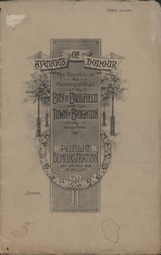
Booklet, D. W. Paterson Co. Pty. Ltd, "AVENUES OF HONOUR The Councils of the Municipalities of the CITY OF CAULFIELD TOWN OF BRIGHTON acting in conjunction PUBLIC DEMONSTRATION SAT 3rd AUG. 1918 AT 3oCLOCK SOUVENIR"
Souvenir Programme from the Councils of the Municipalities of the City of Caulfield and the Town of Brighton for a Public Demonstration to be held on Sat 3rd August 1918 at 3 o'clock for the proposed Avenues of Honour to be planted in memory of fallen WWI soldiers. One of two known copies, this copy has "Town Clerk" stamped in the upper corner, rhs.Commemorative booklet, grey cover with text printed on the grey textured paper and an image of four trees and a wreath. Image of a kookaburra on the back. Inside, 28 numbered pages with b/w text and photographic images including a transparent paper representation of the proposed Avenues of Honour on Brighton Road and Point Nepean Road. Souvenir programme for a Public Demonstration for the Avenues of Honour as detailed on the front. From Honour Roll Display 2019 interpretation panel - Brighton-Caulfield Avenue of Honour It is hard to imagine but a grand arboreal Avenue of Honour once lined parts of North Road, McMillan Street and Point Nepean Road (now Nepean Highway). The Avenue of Honour was a distinctly Australian phenomenon with hundreds being constructed throughout Australia during and following World War One, most of these in Victoria. Consisting of tree lined streets with each tree representing a solider, the Avenue of Honour signalled a more egalitarian approach to commemoration where rank was not a consideration. Arguably the most famous Avenue of Honour in Victoria still exists at Ballarat. Stretching for nearly 22 kilometres, the entrance to the Avenue is marked by the imposing Arch of Victory. Smaller in scale, the Brighton-Caulfield Avenue of Honour was dedicated to the ‘memory of (Brighton and Caulfield’s) kith and kin who came from (the) district and who died in the Great War’. A joint project between the neighbouring Councils, the idea was first reported in The Argus on 1 July 1918. Plans moved along quickly and on 3 August 1918 the Governor of Victoria Arthur Stanley planted the first Australian flowering gum. The next of kin were then invited to plant trees for lost sons, brothers, uncles, nephews and husbands. In all, over 400 trees were planted. Intensely personal, the Avenue also acted as a focus of grief and remembrance for the wider community. For many years, the annual civic Anzac Day service was held at the Avenue on Point Nepean Road, near Glen Huntly Road, Elsternwick. The service was moved to Caulfield Park upon the completion of the Cenotaph in 1930. Due to road widening and disease the last original tree was replaced in the 1980s, however a plaque in Caulfield Park records the Avenue’s plantation. Inkstamp upper corner rhs: "TOWN CLERK" -
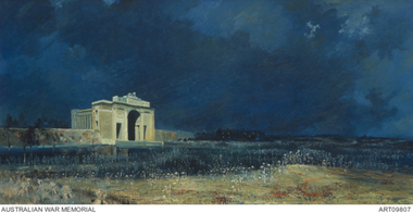 The 5th/6th Battalion Royal Victoria Regiment Historical Collection
Print - Reproduction, framed, The Menin Gate at Midnight
'Menin Gate at midnight' was painted by Will Longstaff to commemorate those soldiers with no marked graves on the Western Front during the First World War; also known as 'Ghosts of Menin Gate'. Longstaff attended a ceremony dedicating the Menin Gate memorial to the soldiers of the British empire forces, just outside the town of Ypres, Belgium, on 24 July 1927. The memorial was dedicated to the 350,000 men of the British and Empire forces who had died in battles around Ypres, and bears the names of 55,000 men with no known grave, over 6,000 of whom were Australians. Longstaff was profoundly moved by what he witnessed and that night, unable to sleep, Longstaff returned to Menin Road and later claimed to have had a vision of spirits of the dead rising out of the soil around him. On returning to his studio in London he painted 'Menin Gate at midnight' in a single session. Today 'Menin Gate at midnight' has achieved the status of a national icon. The painting retains its ability to provoke an emotional response and to communicate the scale of the loss of life and the devastation of war. However as people now have a very different understanding of war, the painting serves a slightly different function. Whereas in the past people responded to the painting as it related to the loss of a loved one and their own personal grief, now the painting communicates the loss experienced by a whole generation. The vast number of those who were killed, and the immensity of the damage wrought during the First World War, requires that those who sacrificed their lives should not be forgotten. Longstaff used well-known motifs to trigger emotion. His scarlet poppies are flowers that could be found in the Flanders fields, but they also carry the traditional connotations of shed blood and remembrance; they represent a floral blanket covering the bloodied bodies of unknown soldiers; at the same time, like the paper poppies worn on Remembrance Day, they are a tribute from the living to the dead. The portrayal of the steel-helmeted soldiers rising from the cornfields extends the range of visual emblems used by Longstaff: the plentiful harvest; the harvest of men; the steel-helmeted crosses covering the graves of many soldiers; and the helmeted bayonets raised in cheer and victory.ww1, menin gate, wark vc club -
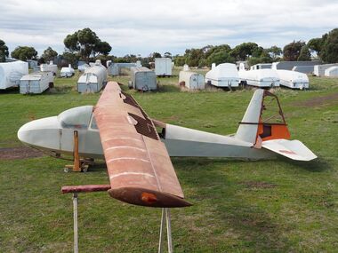 Australian Gliding Museum
Machine - ES56 Nymph Sailplane
ES 56 Nymph Following the successful introduction of the ES 52 Kookaburra two-seater in mid-1954, Edmund Schneider Ltd designed a higher performance single seat sailplane of similar construction and with similar handling qualities. It was designated the ES 56 and became known as the ES56 “Nymph”. The ES56 Nymph was a success in that it delivered the anticipated performance and was found to have satisfactory flying characteristics. However, only the prototype (“Nymph -I”) and three production examples (“Nymph-II”) were built. Schneiders made some changes to the design before building the production version. The wing chord at the tip on the prototype measured 650 mm. This was reduced to 500 mm for subsequent builds. The explanation is that provision was made in the original design for the possible lengthening of the tapered wing to 13 metres. However, apparently it was decided to retain the 11.900 metre span which allowed the tip chord to be reduced slightly. Other changes included the installation of scissor type air brakes in the wing instead of simple hinged flap spoilers and the addition of a landing wheel behind the skid on the fuselage. On one of the Nymph-II a dorsal was added on top of the fuselage forward of the vertical fin when repairs were made rectifying damage incurred as a result of an accident at Benalla on 31 March 1963. Even before these ES56 gliders were finished, Edmund Schneider Ltd decided to offer a less expensive single seat design to cater in particular for newly solo pilots, the ES57 Kingfisher. With the Kingfisher, Schneiders reverted to a traditional airfoil (Gott 549) for the wing instead of the laminar flow section that was chosen for the Nymph in the pursuit of performance. As such, the Kingfisher was more appropriately characterised as a single seat version of the Kookaburra in comparison to the Nymph. Schneiders continued for a time to offer the ES56 Nymph as a high-performance sailplane. However, its place in the market was soon overtaken by imported designs with superior performance, such as the Schleicher KA6, which Schneiders also imported and built under license. Nymph-I was test flown in December 1955 and entered by Harry Schneider into the gliding championships held at Waikerie from 5th to 16th of that month. Harry finished 12th in the individual placing out of a field of approximately 24. The capabilities of the Nymph were further demonstrated by Harry Schneider in January 1956 with a Gold C flight of 193 miles from Gawler in South Australia to Walpeup in Victoria. Nymph-I was acquired by the Port Pirie Gliding Club in South Australia. It has been saved and restored and is a regular feature at vintage glider rallies in Victoria and New South Wales. See Museum Newsletter No 35 Winter Edition 2017 pages 3 -6, for that story. The Nymph-II production models were delivered by Edmund Schneider Ltd in October 1956 to the Gliding Club of Victoria, the Victorian Motorless Flight Group and the Royal Australian Navy Gliding Association. The VMFG flew its Nymph in the First National Gliding Championships at Tocumwal, NSW, in December 1956 and all three were flown at the Second National Gliding Championships at Benalla in 29th December 1958 to 8th January 1959, delivering competitive performances based on handicap. Nymph-I Serial Number 17 Original owner – Port Pirie Gliding Club, S.A. Registered VH-GHG on 20 August 1957 Re-registered VH-GHA on 11 October 2016 Currently Raywood, Victoria Believed airworthy Nymph-II Serial Number 20 Original owner – R.A.N. Gliding Association Registered VH-GDX on 20 May 1957 Currently Locksley, Victoria. In storage Nymph-II Serial Number 21 Original owner – Gliding Club of Victoria Registered VH-GHU on 27 August 1957 Currently Bendick Murrell, N.S.W. In storage Nymph-II Serial Number 22 Original owner – Victorian Motorless Flight Group Registered VH-GFE on 5 March 1957 Currently Bacchus Marsh, Victoria Under restoration for display. The Museum’s exhibit is the ES56, serial number 22, registered as VH-GFE. The glider was flown by the VMFG in Victoria until approximately September 1968. GFA records show that it was transferred to Queensland in 1968, and it passed through several owners until the mid-1970s. Information received indicates that it was flown by the Leichardt Soaring Club at Mount Isa in the (late?) 1960s. The history from then is not presently known except to say that it has been kept in dry storage for many years. It is not known when the glider was last flown. What is Significant? The Schneider ES 56 Nymph single seat sailplane, serial number 22, designed and built in 1955-1956, by Edmund Schneider Ltd in Adelaide. It was delivered to its original owner, the Victorian Motorless Flight Group, in October 1956, and registered as VH-GFE on 5 March 1957. How it is Significant? The ES56 Nymph is of historical, aesthetic, scientific and research, and social significance to the Australian gliding community. Why it is Significant? The ES56 is of historical significance as it was designed and built by Edmund and Harry Schneider. The Schneiders immigrated to Australia after the end of the second world war bringing with them considerable expertise in relation to glider design and construction. Over the following decades they maintained a close association with the Gliding Federation of Australia and the gliding clubs and through their glider production made a major contribution to the sport. The ES56 is part of that story. The ES56 in its design and construction exhibits the glider construction technology of the time, which principally consisted of lightweight wooden framework skinned with ply and doped fabric. It exbibits design innovation, notably the use of a laminar flow wing profile in pursuit of better glide performance. Also, considerable attention was given to simplifying the structure in order to keeping cost and the weight low. The ES56 played a useful role at gliding clubs where it was operated, especially the late 1950s and early 1960s and is remembered well by pilots who flew her. The glider is in the course of restoration and provides an insight into the skills and workmanship that were involved in design, building and maintenance of these wooden aircraft. It is of aesthetic and scientific and research significance. Glider airframe of a traditional wood and fabric covered constructionNoneglider, sailplane, edmund schneider, harry schneider, es56, nymph, es57, kingfisher, victorian motorless flight group, gliding club of victoria, ran gliding association, port pirie gliding club, leichardt soaring club. -
 Flagstaff Hill Maritime Museum and Village
Ceramic - Stoneware Bottle, Henry Kennedy Pottery, Late 1800s to early 1900s
This bottle was made in Scotland and recovered decades later from a shipwreck along the coast of Victoria. It may have been amongst the ship's cargo, its provisions or amongst a passenger's personal luggage. It is now part of the John Chance collection. Stoneware bottles similar to this one were in common use during the mid-to-late 19th century. They were used to store and transport. The bottles were handmade using either a potter's wheel or in moulds such as a plaster mould, which gave the bottles uniformity in size and shape. The bottle would then be fired and glazed in a hot kiln. Makers often identified their bottles with the impression of a small symbol or adding a colour to the mouth. The manufacturer usually stamped their bottles with their name and logo, and sometimes a message that the bottle remained their property and should be returned to them. The bottles could then be cleaned and refilled. The Barrowfield pottery was founded in 1866 by Henry Kennedy, an Irish native, in the Camlachie district east of Glasgow, close to the Campbellfield and Mount Blue potteries. It is believed that Kennedy started with just one kiln but by 1871 was employing forty men and six boys and such was the success of the enterprise that by 1880, no less than eight kilns were in operation and a year later one hundred and the pottery was employing eighteen people. Stoneware bottle production was a mainstay of the pottery and over “1500 dozen” were being turned out daily along with other wares, including 30-gallon ironstone containers. With so many kilns in operation, six hundred saggars were required every week but, unlike some potteries, these were made on the premises from Garnkirk and Glenboig fire clays. Pottery production reaches a high scale which presented a high risk of fire and Barrowfield was no exception. In April 1884 heat from a kiln set fire to the roof resulting in significant structural damage, the loss of unfinished wares alone amounting to £10,000 a very substantial sum in 1884. The pottery recovered from this reverse but then Henry Kennedy died in July 1890. The terms of his will indicated that he and his sons John and Joseph were partners and this was reflected in a change of title in the 1891-92 Post Office Directory to Henry Kennedy & Sons. Despite the growth of the business there was still space enough, however, to allow china, earthenware and glass retailers Daniel and John McDougall to commence production of their Nautilus wares there in 1894, the success of which allowed them to soon move to permanent quarters at the empty Saracen Pottery, Possil. In around 1900 John Kennedy left to resurrect the liquidated Cleland Pottery and although Barrowfield remained listed as Henry Kennedy & Sons, brother Joseph was in control. In 1911 Henry Kennedy & Sons Ltd was formed, with two of the four directors being the Kennedy brothers. The pottery’s growth to this point was reflected in the eighteen kilns the largest pottery kilns then recorded in Scotland. However, the disruption of the First World War and the combined effects of subsequent economic depression, US prohibition, hygiene regulations and competition from alternative materials posed severe challenges for stoneware potteries in the post-war years as they competed with each other for diminishing markets. Competitors such as Eagle and Caledonian Potteries fell by the wayside and finally, Barrowfield closed in 1929. This stoneware bottle is historically significant for its manufacture and use in the late 19th to the early 20th century. The bottle is also significant as it was recovered by John Chance, a diver, from a wreck on the coast of Victoria in the 1960s-70s. Items that come from several wrecks along Victoria's coast have since been donated to the Flagstaff Hill Maritime Village’s museum collection by his family, illustrating this item’s level of historical value. Stoneware was produced at Barrowfield pottery for the domestic and export markets, with South America being a large market. Barrowfield stoneware can be found throughout the world. Its longevity and abundant production makes the subject item a significant addition to the Flagstaff Hill Maritime Museum collection.Bottle, salt glazed stoneware, beige, some discolouration above base. Chip on base and on neck. Inscriptions stamped near base.Makers lozenge stamped, H Kennedy Barrowfield Pottery GLASGOW at base.flagstaff hill, warrnambool, flagstaff hill maritime museum, maritime museum, shipwreck coast, flagstaff hill maritime village, great ocean road, john chance, h kennedy pottery, stoneware, ironstone, pottery, barrowfield glasgow -
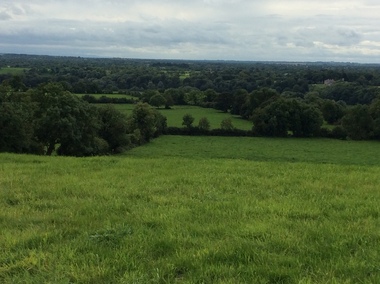
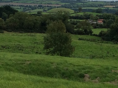
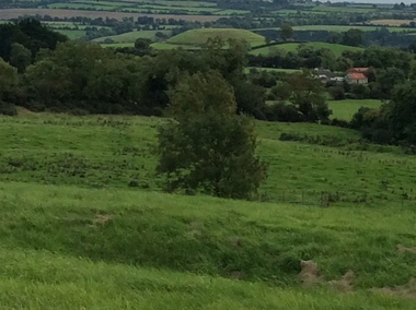
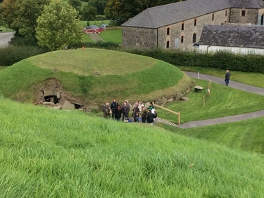
 Ballarat Heritage Services
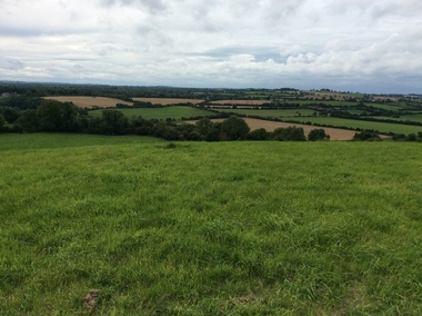
Photograph - Colour, Knowth and New Grange, Ireland, World Heritage Centre
The Megalithic Passage Tombs of Newgrange, Knowth, Dowth, Fourknocks, Loughcrew and Tara are located in the present day County Meath in Ireland's Ancient East. The Boyne Valley Mounds at Newgrange, Knowth and Dowth were built around 3200BC making them older than Stonehenge in England and the Pyramids of Giza in Egypt. Built by Neolithic farming communities about 5000 years ago, the passage tombs have clear astronomical alignments such as the Winter Solstice Sunrise at Newgrange and the Equinox Sunrise at Loughcrew. Judging from the splendour and magnificence of Newgrange and Knowth it is likely that these temples of the ancestors were places of astrological, spiritual, religious and ceremonial importance, much as present day cathedrals are places of worship where dignitaries may be laid to rest. There is a lively debate about whether these wonderful megalithic structures were built primarily as burial tombs, sacred temples or astronomical observatories. While passage tomb is the traditional description for Newgrange and similar structures, chambered cairn or passage mound are the descriptions favoured by those who consider the passage tomb description too narrow. The large stones surrounding and inside the Passage Tombs are decorated with Megalithic Art such as spirals, concentric circles, triangles, zigzags and images which have been interpreted as the sun, moon and the human face. Irish passage tombs tend to occur in clusters traditionally described as a Necropolis or cemetery. The Boyne cluster includes Newgrange, Knowth, Dowth and Townleyhall. The other great clusters in County Meath are on the hills around Loughcrew. The ancient Boyne Valley passage tomb mounds at Newgrange, Knowth and Dowth have been designated World Heritage Site status by UNESCO and attract 200,000 visitors per year. The sites and Visitor Centre are managed by the OPW (Office of Public Works). Newgrange is best known for the illumination of its passage and chamber by the winter solstice sun. The site is open to the public with controlled access to the passage and chamber. Tours of Newgrange start at the Brú na Bóinne Visitor Centre located near the village of Donore, Co. Meath. Knowth has two passages and is surrounded by seventeen satellite cairns. The site is open to the public; however there is no public access to the interior passages and chambers. Tours of Knowth also start at the Brú na Bóinne Visitor Centre. Dowth is the only one of the three large Brú na Bóinne Passage Tombs which is not accessible from the Visitor Centre situated on the south bank of the river. Visitors to Dowth must drive directly to the site on the north bank, a couple of miles from the Slane / Drogheda road. Fourknocks with its short passage leading into a wide pear shaped chamber is in similar style to Tombs in Portugal. Just inside the main chamber to the left of the entrance is one of the few representations of a human face from the Neolithic Period in ancient Ireland. Entrance to Fourknocks Megalithic Passage Tomb. Megalithic Art - Loughcrew, Co. Meath Loughcrew Cairns form the largest complex of Megalithic structures in Ireland. The Cairns contain symbolic engravings similar in style to Newgrange. Like other Passage Tombs in ancient Ireland, they have clear astrological alignments.Tara was the seat of the High Kings of Ireland in the first millennium A.D. however Tara is also the site of a Passage Tomb known as the Mound of the Hostages that was built about 2,500 B.C. knowth, newgrange, megalith, ireland, world heritage, neolithic -
 Ballarat Heritage Services
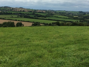
Photograph - Colour, Knowth and New Grange, Ireland, World Heritage Centre
The Megalithic Passage Tombs of Newgrange, Knowth, Dowth, Fourknocks, Loughcrew and Tara are located in the present day County Meath in Ireland's Ancient East. The Boyne Valley Mounds at Newgrange, Knowth and Dowth were built around 3200BC making them older than Stonehenge in England and the Pyramids of Giza in Egypt. Built by Neolithic farming communities about 5000 years ago, the passage tombs have clear astronomical alignments such as the Winter Solstice Sunrise at Newgrange and the Equinox Sunrise at Loughcrew. Judging from the splendour and magnificence of Newgrange and Knowth it is likely that these temples of the ancestors were places of astrological, spiritual, religious and ceremonial importance, much as present day cathedrals are places of worship where dignitaries may be laid to rest. There is a lively debate about whether these wonderful megalithic structures were built primarily as burial tombs, sacred temples or astronomical observatories. While passage tomb is the traditional description for Newgrange and similar structures, chambered cairn or passage mound are the descriptions favoured by those who consider the passage tomb description too narrow. The large stones surrounding and inside the Passage Tombs are decorated with Megalithic Art such as spirals, concentric circles, triangles, zigzags and images which have been interpreted as the sun, moon and the human face. Irish passage tombs tend to occur in clusters traditionally described as a Necropolis or cemetery. The Boyne cluster includes Newgrange, Knowth, Dowth and Townleyhall. The other great clusters in County Meath are on the hills around Loughcrew. The ancient Boyne Valley passage tomb mounds at Newgrange, Knowth and Dowth have been designated World Heritage Site status by UNESCO and attract 200,000 visitors per year. The sites and Visitor Centre are managed by the OPW (Office of Public Works). Newgrange is best known for the illumination of its passage and chamber by the winter solstice sun. The site is open to the public with controlled access to the passage and chamber. Tours of Newgrange start at the Brú na Bóinne Visitor Centre located near the village of Donore, Co. Meath. Knowth has two passages and is surrounded by seventeen satellite cairns. The site is open to the public; however there is no public access to the interior passages and chambers. Tours of Knowth also start at the Brú na Bóinne Visitor Centre. Dowth is the only one of the three large Brú na Bóinne Passage Tombs which is not accessible from the Visitor Centre situated on the south bank of the river. Visitors to Dowth must drive directly to the site on the north bank, a couple of miles from the Slane / Drogheda road. Fourknocks with its short passage leading into a wide pear shaped chamber is in similar style to Tombs in Portugal. Just inside the main chamber to the left of the entrance is one of the few representations of a human face from the Neolithic Period in ancient Ireland. Entrance to Fourknocks Megalithic Passage Tomb. Megalithic Art - Loughcrew, Co. Meath Loughcrew Cairns form the largest complex of Megalithic structures in Ireland. The Cairns contain symbolic engravings similar in style to Newgrange. Like other Passage Tombs in ancient Ireland, they have clear astrological alignments.Tara was the seat of the High Kings of Ireland in the first millennium A.D. however Tara is also the site of a Passage Tomb known as the Mound of the Hostages that was built about 2,500 B.C. knowth, newgrange, megalith, ireland, world heritage, neolithic -
 Ballarat Heritage Services
Photograph - Colour, Knowth and New Grange, Ireland, World Heritage Centre
The Megalithic Passage Tombs of Newgrange, Knowth, Dowth, Fourknocks, Loughcrew and Tara are located in the present day County Meath in Ireland's Ancient East. The Boyne Valley Mounds at Newgrange, Knowth and Dowth were built around 3200BC making them older than Stonehenge in England and the Pyramids of Giza in Egypt. Built by Neolithic farming communities about 5000 years ago, the passage tombs have clear astronomical alignments such as the Winter Solstice Sunrise at Newgrange and the Equinox Sunrise at Loughcrew. Judging from the splendour and magnificence of Newgrange and Knowth it is likely that these temples of the ancestors were places of astrological, spiritual, religious and ceremonial importance, much as present day cathedrals are places of worship where dignitaries may be laid to rest. There is a lively debate about whether these wonderful megalithic structures were built primarily as burial tombs, sacred temples or astronomical observatories. While passage tomb is the traditional description for Newgrange and similar structures, chambered cairn or passage mound are the descriptions favoured by those who consider the passage tomb description too narrow. The large stones surrounding and inside the Passage Tombs are decorated with Megalithic Art such as spirals, concentric circles, triangles, zigzags and images which have been interpreted as the sun, moon and the human face. Irish passage tombs tend to occur in clusters traditionally described as a Necropolis or cemetery. The Boyne cluster includes Newgrange, Knowth, Dowth and Townleyhall. The other great clusters in County Meath are on the hills around Loughcrew. The ancient Boyne Valley passage tomb mounds at Newgrange, Knowth and Dowth have been designated World Heritage Site status by UNESCO and attract 200,000 visitors per year. The sites and Visitor Centre are managed by the OPW (Office of Public Works). Newgrange is best known for the illumination of its passage and chamber by the winter solstice sun. The site is open to the public with controlled access to the passage and chamber. Tours of Newgrange start at the Brú na Bóinne Visitor Centre located near the village of Donore, Co. Meath. Knowth has two passages and is surrounded by seventeen satellite cairns. The site is open to the public; however there is no public access to the interior passages and chambers. Tours of Knowth also start at the Brú na Bóinne Visitor Centre. Dowth is the only one of the three large Brú na Bóinne Passage Tombs which is not accessible from the Visitor Centre situated on the south bank of the river. Visitors to Dowth must drive directly to the site on the north bank, a couple of miles from the Slane / Drogheda road. Fourknocks with its short passage leading into a wide pear shaped chamber is in similar style to Tombs in Portugal. Just inside the main chamber to the left of the entrance is one of the few representations of a human face from the Neolithic Period in ancient Ireland. Entrance to Fourknocks Megalithic Passage Tomb. Megalithic Art - Loughcrew, Co. Meath Loughcrew Cairns form the largest complex of Megalithic structures in Ireland. The Cairns contain symbolic engravings similar in style to Newgrange. Like other Passage Tombs in ancient Ireland, they have clear astrological alignments.Tara was the seat of the High Kings of Ireland in the first millennium A.D. however Tara is also the site of a Passage Tomb known as the Mound of the Hostages that was built about 2,500 B.C. knowth, newgrange, megalith, ireland, world heritage, neolithic -
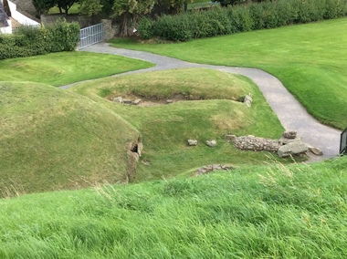 Ballarat Heritage Services
Photograph - Colour, Knowth and New Grange, Ireland, World Heritage Centre
The Megalithic Passage Tombs of Newgrange, Knowth, Dowth, Fourknocks, Loughcrew and Tara are located in the present day County Meath in Ireland's Ancient East. The Boyne Valley Mounds at Newgrange, Knowth and Dowth were built around 3200BC making them older than Stonehenge in England and the Pyramids of Giza in Egypt. Built by Neolithic farming communities about 5000 years ago, the passage tombs have clear astronomical alignments such as the Winter Solstice Sunrise at Newgrange and the Equinox Sunrise at Loughcrew. Judging from the splendour and magnificence of Newgrange and Knowth it is likely that these temples of the ancestors were places of astrological, spiritual, religious and ceremonial importance, much as present day cathedrals are places of worship where dignitaries may be laid to rest. There is a lively debate about whether these wonderful megalithic structures were built primarily as burial tombs, sacred temples or astronomical observatories. While passage tomb is the traditional description for Newgrange and similar structures, chambered cairn or passage mound are the descriptions favoured by those who consider the passage tomb description too narrow. The large stones surrounding and inside the Passage Tombs are decorated with Megalithic Art such as spirals, concentric circles, triangles, zigzags and images which have been interpreted as the sun, moon and the human face. Irish passage tombs tend to occur in clusters traditionally described as a Necropolis or cemetery. The Boyne cluster includes Newgrange, Knowth, Dowth and Townleyhall. The other great clusters in County Meath are on the hills around Loughcrew. The ancient Boyne Valley passage tomb mounds at Newgrange, Knowth and Dowth have been designated World Heritage Site status by UNESCO and attract 200,000 visitors per year. The sites and Visitor Centre are managed by the OPW (Office of Public Works). Newgrange is best known for the illumination of its passage and chamber by the winter solstice sun. The site is open to the public with controlled access to the passage and chamber. Tours of Newgrange start at the Brú na Bóinne Visitor Centre located near the village of Donore, Co. Meath. Knowth has two passages and is surrounded by seventeen satellite cairns. The site is open to the public; however there is no public access to the interior passages and chambers. Tours of Knowth also start at the Brú na Bóinne Visitor Centre. Dowth is the only one of the three large Brú na Bóinne Passage Tombs which is not accessible from the Visitor Centre situated on the south bank of the river. Visitors to Dowth must drive directly to the site on the north bank, a couple of miles from the Slane / Drogheda road. Fourknocks with its short passage leading into a wide pear shaped chamber is in similar style to Tombs in Portugal. Just inside the main chamber to the left of the entrance is one of the few representations of a human face from the Neolithic Period in ancient Ireland. Entrance to Fourknocks Megalithic Passage Tomb. Megalithic Art - Loughcrew, Co. Meath Loughcrew Cairns form the largest complex of Megalithic structures in Ireland. The Cairns contain symbolic engravings similar in style to Newgrange. Like other Passage Tombs in ancient Ireland, they have clear astrological alignments.Tara was the seat of the High Kings of Ireland in the first millennium A.D. however Tara is also the site of a Passage Tomb known as the Mound of the Hostages that was built about 2,500 B.C. knowth, newgrange, megalith, ireland, world heritage, neolithic -
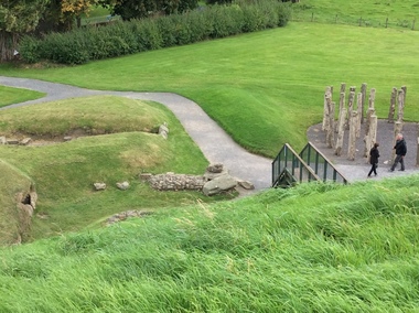 Ballarat Heritage Services
Photograph - Colour, Knowth and New Grange, Ireland, World Heritage Centre
The Megalithic Passage Tombs of Newgrange, Knowth, Dowth, Fourknocks, Loughcrew and Tara are located in the present day County Meath in Ireland's Ancient East. The Boyne Valley Mounds at Newgrange, Knowth and Dowth were built around 3200BC making them older than Stonehenge in England and the Pyramids of Giza in Egypt. Built by Neolithic farming communities about 5000 years ago, the passage tombs have clear astronomical alignments such as the Winter Solstice Sunrise at Newgrange and the Equinox Sunrise at Loughcrew. Judging from the splendour and magnificence of Newgrange and Knowth it is likely that these temples of the ancestors were places of astrological, spiritual, religious and ceremonial importance, much as present day cathedrals are places of worship where dignitaries may be laid to rest. There is a lively debate about whether these wonderful megalithic structures were built primarily as burial tombs, sacred temples or astronomical observatories. While passage tomb is the traditional description for Newgrange and similar structures, chambered cairn or passage mound are the descriptions favoured by those who consider the passage tomb description too narrow. The large stones surrounding and inside the Passage Tombs are decorated with Megalithic Art such as spirals, concentric circles, triangles, zigzags and images which have been interpreted as the sun, moon and the human face. Irish passage tombs tend to occur in clusters traditionally described as a Necropolis or cemetery. The Boyne cluster includes Newgrange, Knowth, Dowth and Townleyhall. The other great clusters in County Meath are on the hills around Loughcrew. The ancient Boyne Valley passage tomb mounds at Newgrange, Knowth and Dowth have been designated World Heritage Site status by UNESCO and attract 200,000 visitors per year. The sites and Visitor Centre are managed by the OPW (Office of Public Works). Newgrange is best known for the illumination of its passage and chamber by the winter solstice sun. The site is open to the public with controlled access to the passage and chamber. Tours of Newgrange start at the Brú na Bóinne Visitor Centre located near the village of Donore, Co. Meath. Knowth has two passages and is surrounded by seventeen satellite cairns. The site is open to the public; however there is no public access to the interior passages and chambers. Tours of Knowth also start at the Brú na Bóinne Visitor Centre. Dowth is the only one of the three large Brú na Bóinne Passage Tombs which is not accessible from the Visitor Centre situated on the south bank of the river. Visitors to Dowth must drive directly to the site on the north bank, a couple of miles from the Slane / Drogheda road. Fourknocks with its short passage leading into a wide pear shaped chamber is in similar style to Tombs in Portugal. Just inside the main chamber to the left of the entrance is one of the few representations of a human face from the Neolithic Period in ancient Ireland. Entrance to Fourknocks Megalithic Passage Tomb. Megalithic Art - Loughcrew, Co. Meath Loughcrew Cairns form the largest complex of Megalithic structures in Ireland. The Cairns contain symbolic engravings similar in style to Newgrange. Like other Passage Tombs in ancient Ireland, they have clear astrological alignments.Tara was the seat of the High Kings of Ireland in the first millennium A.D. however Tara is also the site of a Passage Tomb known as the Mound of the Hostages that was built about 2,500 B.C. knowth, newgrange, megalith, ireland, world heritage, neolithic