Showing 1247 items
matching mine buildings
-
 Bendigo Historical Society Inc.
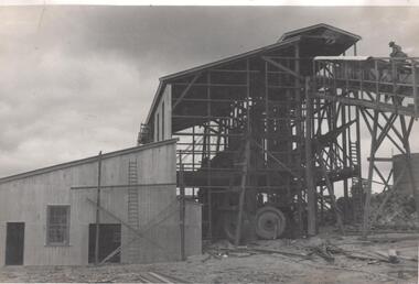
Photograph - Napoleon Reef Gold Battery Winder Shed, 1936
The Napoleon mine site was situated near Harvey Street and Union Street, Ironbark. It was registered under the Companies Act in 1940, with John Jepson Stanistreet as Manager. Article in Age newspaper: https://trove.nla.gov.au/newspaper/article/206767750?searchTerm=napoleon%20reef%20mineSignificant to mining history of Bendigo.Black and white photograph: large wooden frame for winder shed, carpenters' 'horses' in foreground. Written in pencil on back of photograph: ' ...winder shed 21/10/36' and 'cracker station building'napoleon gold mine, napoleon reef gold mine -
 Clunes Museum
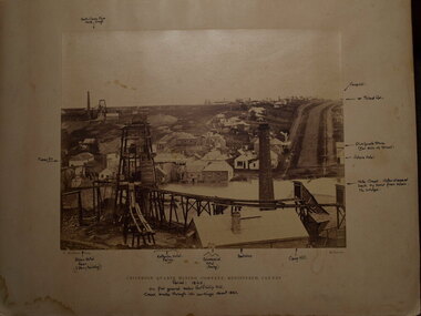
Photograph, TOWN OF CLUNES, 1886
CLUNES TOWNSHIP IN 1886BLACK WOODEN FRAMED PHOTOGRAPH OF CLUNES. HAND TINTED WITH A NARRATIVE WHICH WAS GLUED ONTO THE GLASS. VIEW LOOKING SOUTH NEAR THE PRESENT DAY SCENIC ROAD LOOKOUT.TOWN OF CLUNES - Population 4874 - Number of dwellings 1100. Gold first discovered here 1st July 1851 Printed narrative: A hand-tinted photo-engraving from the Handbook of Victoria, published for the Colonial and Indian Exhibition in London, 1886. Looking south from near the present-day Scenic Road lookout, the illustration projects the image of Clunes as a goldmining town The view shows the headframes of several mine shafts, the Central Clunes Q.M.Co., and the Boundary, No.1 and No.2 shafts of the South Clunes G.M.Co. The headframe on the skyline in the middle distance was probably that of the Bute & Downes Amalgamated G.M.Co., near the railway station. colonial and indian exhibition in london 1886, bute & downes amalgamated, buildings, mining -
 Bendigo Historical Society Inc.
Slide - HORWOOD COLLECTION: DEBORAH EXTENDED, c1850s
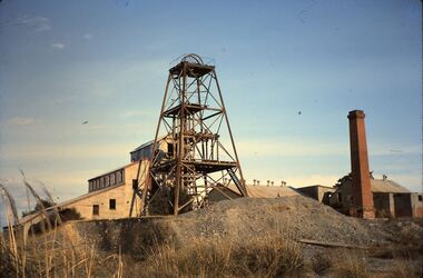
BHS CollectionHorwood Collection. Shows Deborah Extended poppet head with corrugated building and chimney, and mullock heap. Markings: Deborah Ext'dKodakmine, gold, deborah extended, horwood collection. shows deborah extended poppet head with corrugated building and chimney, and mullock heap -
 Lakes Entrance Historical Society
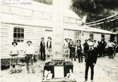
Photograph - Goldmining Walhalla, J Phillips, December 1885
Detailed information on back of photograph regarding gold amountsBlack and white photograph showing the exhibits to be sent to the colonial and Indian Exhibition London by the Long Tunnel Company Many men in the photograph in front of weatherboard building Mechanics Institute Walhalla VictoriaSee Walhalla Memorialmines and mining, exhibition -
 Bendigo Historical Society Inc.
Document - Geological Survey of Victoria, Hustlers Line of Reef, Bendigo, April, 2014
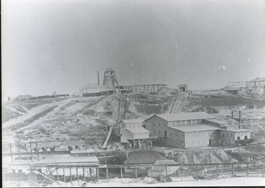
Seven men were killed at the Great Extended Hustler's mine disaster on 2nd May 1914 by an explosion of dynamite occurring as the men were waiting at the plat to ascend the mine at the end of their shift. No blame was attached to anyone in the findings of the inquisition. It was unknown what caused the dynamite to explode. This document formed part of the research done at the time by Bendigo Historical Society, of the 100 years commemoration of the mine disaster, held at Hustler's Hill in 2014. Seven page photocopy of Department of Mines, Bulletin, Geological Survey of Victoria, Hustlers Line of Reef, Bendigo, No. 33 by H.S. Whitelaw. Includes plan of Hustlers Royal Reserve No. 2, (main shaft) showing location on Pall Mall, and location of Post Office and Law Courts; plan of location of Hustlers Royal Reserve No. 2 (Park Shaft) showing Jail (sic), Camp Hill State School, two 'lagoons' in between tennis court, croquet court and bowling green; a plan of the Great Extended Hustler's Shaft and two copied images of Hustler's Hill showing mining buildings, poppet heads and chimneys. Comet, K.K., Hustler's No. 1, Old Comet and United Hustler's and Redan Mines are shown in the images. great extended hustlers, goldmining, accident, quartz, mining, k.k. mine, comet mine, hustler's line of reef, old comet, united hustler's, redan -
 Bendigo Historical Society Inc.
Newspaper - LONG GULLY HISTORY GROUP COLLECTION: E BRYANT - GROCER
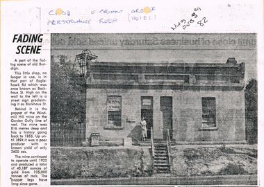
BHS CollectionCopy of a newspaper article titled Fading Scene. Photo shows a building with a stairway leading down to the road in front of it and a lady standing in the doorway. One window has Cash Store printed on it and there are two placards leaning on the building to the left of the lady. Each side of the building are shrubs and picket fence. In the background to the left is the poppet of the Windmill Hill Mine on the Garden Gully line of reef. It is in that part of Eaglehawk Rd which was once known as Backhaus St. High on the wall to the left is a street sign proclaiming it as Backhaus St. Written above the photo is C-sh, E Bryant, Gro-er (there are holes through the words), Perseverance Reef (Hotel). Wed Feb 3rd 82. Article is mounted on yellow card which is mounted on purple card and laminated.bendigo, history, long gully history group, the long gully history group - e bryant - grocer, windmill hill mine, garden gully line of reef, e bryant, perservance reef (hotel) -
Clunes Museum
Document - CONSERVATION PLAN, SHIRE OF HEPBURN, SCHOOL OF MINES, 2000
SCHOOL OF MINES, CLUNES BRANCH N0.12, FORMED 1886. ALSO SUPPORTED LOYAL CLUNES LODGE OF ODDFELLOWS, CLUNES INDEPENDENT ORDER OF RECHABITES, A BRANCH OF AUSTRALIAN WOMEN'S ASSOCIATION. IN 1891 ANA (AUSTRALIAN NATIVES ASSOCIATION) 1935 CWA, INNERSPRING MATTRESS FACTORY, CLUNES, INFANT WELFARE, CLUNES ANGLING CLUB NOW OCCUPIES THE BUILDING.SPIRAL BOUND DOCUMENT WITH THE FORMER CLUNES SCHOOL OF MINES DEPICTED IN COLOUR ON THE FRONT PAGE. CONTAINS A CONSERVATION MANAGEMENT PLAN WITH HISTORICAL DETAIL AND COLOURED PHOTOGRAPHS OF THE BUILDING AND SURROUNDSlocal history, conservation management plan, school of mines -
 Clunes Museum
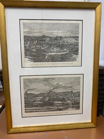
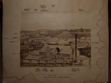
Print, R GROSSE
.1 TWO PRINTS, ONE ABOVE THE OTHER, COPIED TO BUFF COLOURED PAPER, MOUNTED IN GOLD COLOURED TIMBER FRAME. PRINTS TAKEN FROM LITHOGRAPHS .2 FRAMED COLOUR PRINT OF TOWNSHIP OF CLUNES APPROX 1890'S. SAME AS TOP IMAGE OF .1TOP IMAGE PRINTED IN BLACK: TOWN OF CLUNES - POPULATION 4874 NUMBER OF BUILDINGS 1100 GOLD FIRST DISCOVERED HERE Ist JULY 1851 BOTTOM IMAGE PRINTED IN BLACK: PORT PHILLIP AND COLONIAL GOLD MINING COMPANY CLUNESport phillip mine, township of clunes -
 Bendigo Historical Society Inc.
Photograph - Napoleon Mine Battery, 1936
The Napoleon (BML) gold mine (1932) was located beside McDougall Road, Golden Gully, between Martin and Hattam Street. It had a depth of 921 feet. It was one of the latest and most lavish of Bendigo's mines. Plant and equipment were electrically driven. The four-compartment shaft, extra large by goldfield's standards, measured 17 feet 6 inches by 5 feet 2 inches and was cement lined below 900 feet instead of being red gum boxed as was the usual practice. The workshop was equipped to carry out all repairs for the equally lavish BML mines on the Nell Gwynne and Carshalton reefs. (The Gold Mines of Bendigo, Book 2, Arthur Victor Palmer)Significant to mining history of Bendigo.Black and white photograph: battery shed under erectionWritten in pencil on back of photograph: 'battery erection 17/1`1/36' and 'cracker station building' napoleon gold mine, napoleon reef gold mine -
 Clunes Museum
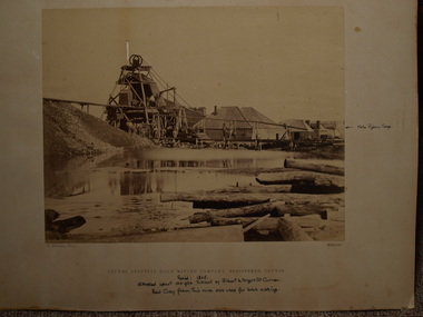
Photograph, C. NETTLETON, APPROX. 1865
THIS MINE WAS SITUATED ABOUT 100 YARDS SOUTH WEST OF ALBERT STREET AND ANGUS STREET CORNER. RED CLAY FROM THIS MINE WAS USED FOR BRICK MAKING..1 SEPIA PHOTOGRAPH OF CLUNES ALLUVIAL GOLD MINING CO. .2 SEPIA PHOTOGRAPH OF POPPET HEAD-MINERS ON PLATFORM-THATCHED ROOF BUILDINGS, SCATTERING OF LARGE LOGS IN FOREGROUND, USED FOR FIRES. .3 COPY OF ABOVE PHOTOGRAPH IN BLACK AND WHITE (POSTCARD SIZE).1 PRINTED: CLUNES ALLUVIAL GOLD MINING COMPANY REGISTERED CLUNES .2 PRINTED ON FRONT : ALLUVIAL GOLD MINING COMPANY REGISTERED CLUNES HANDWRITTEN: PERIOD 1865. SITUATED ABOUT 100 YDS SW OF ALBERT AND ANGUS STREET CORNER. RED CLAY FROM THIS MINE WAS USED FOR BRICK MAKINGphotographs, mining, clunes alluvial mining company -
 Clunes Museum
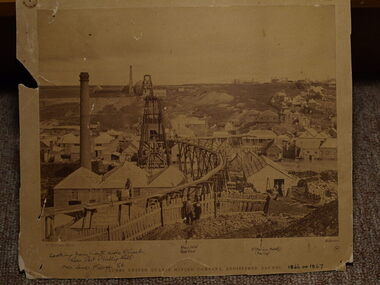
Photograph, C. NETTLETON, PORT PHILLIP MINE, APPROX. 1866 OR 1867
PHOTOGRAPH OF PORT PHILLIP MINE ABOUT 186 OR 1867. NOTE COVERED FLUE TO BRICK CHIMNEY TO RIGHT. IN 1966 THERE WERE A FEW BRICKS AT THE SIGHT OF THE CHIMNEY AND A SHALLOW TRENCH ALONG THE LINE OF THE FLUE. SITE OF PRESENT GOLD MONUMENT IS JUST TO RIGHT OF POPPET HEAD SHOWN ON HILL. WOOD PILE OUTSIDE BUILDING TROLLEY LINES ETC.SEPIA PHOTOGRAPH OF PORT PHILLIP AND COLONIAL GOLD MINING COMPANY, CLUNES. PHOTOGRAPH TAKEN FROM CAMP PARADE, LOOKING NORTH. GENERAL VIEW OF MINE AND WORKS IN 1866 OR 1867.photographs, mining, port phillip and colonial gold mining company -
 Clunes Museum
Photograph, C. NETTLETON
.1 SEPIA PHOTOGRAPH OF CLUNES UNITED QUARTZ MINE .2 BLACK AND WHITE PHOTO PRINT .3 SMALL BLACK AND WHITE PHOTO PRINT WITH HISTORY WRITTEN ON BACK BY F C WEICKHARDT .4 SMALL BLACK AND WHITE PHOTO PRINT .5 SMALL SEPIA PRINTCLUNES UNITED QUARTZ MINING COMPANY, REGISTERED, CLUNES. WITH HANDWRITTEN NOTES: LOOKING FROM NORTH SIDE OF CREEK NEAR PORT PHILLIP HILL OVER LOWER FRASER STREET VARIOUS NOTATIONS INCLUDING LOCATION OF BUILDINGS, INCLUDING ALBION HOTEL, CRITERION HOTELlocal history, photography, photographs, mining -
 Clunes Museum
Photograph, 1866 - 1867
.1 SEPIA PHOTOGRAPH MOUNTED ON CARDBOARD OF CRITERION QUARTZ MINE, CLUNES. .2 SEPIA PHOTOGRAPH MOUNTED ON CARDBOARD .3 SMALL BLACK AND WHITE PHOTO PRINT .4 ONE MEDIUM SIZE BLACK AND WHITE COPY .5 BLACK AND WHITE PHOTO PRINT .6 MOUNTED BLACK AND WHITED PRINT CRITERION QUARTZ MINING COMPANY, REGISTERED, CLUNES. HANDWRITTEN NOTES: PERIOD 1865, ON FLAT GROUND BELOW PORT PHILLIP HILL CREEK BROKE THROUGH INTO WORKINGS ABOUT 1861 VARIOUS NOTATIONS MARKING LOCATION OF BUILDINGS IN CLUNES, INCLUDING PICKFORDS STORE, VICTORIA HOTEL, CAMP HILL, ALBION HOTEL, CRITERION HOTEL, COMMERCIAL HOTEL, BOOT SHOPlocal history, photography, photographs, mining -
 Clunes Museum
Photograph, C. NETTLETON, CIRCA 1865
SEPIA PHOTOGRAPH AND PHOTOCOPY OF CLUNES UNITED QUARTZ MINING COMPANY, TALL CHIMNEY ON RIGHT HAND SIDE.CLUNES UNITED QUARTZ MINING COMPANY REGISTERED CLUNES HANDWRITTEN NOTES: PERIOD 1865 TAKEN FROM HILLSIDE BELOW PORT PHILLIP MINE (SOUTH) LOCATIONS OF VARIOUS BUILDINGSlocal history, photography, photographs, mining -
 Bendigo Historical Society Inc.
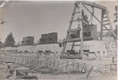
Photograph - Napoleon Reef Gold Mine Battery Site, 1936
The Napoleon (BML) gold mine (1932) was located near McDougall Road, Golden Gully, between Martin and Hattam Street. It had a depth of 921 feet. It was one of the latest and most lavish of Bendigo's mines. Plant and equipment were electrically driven. The four-compartment shaft, extra large by goldfield's standards, measured 17 feet 6 inches by 5 feet 2 inches and was cement lined below 900 feet instead of being red gum boxed as was the usual practice. The workshop was equipped to carry out all repairs for the equally lavish BML mines on the Nell Gwynne and Carshalton reefs. (The Gold Mines of Bendigo, Book 2, Arthur Victor Palmer) 'Napoleon BML Mines No Liability have issued a report for the fortnight ended September 5, where it states that the development scheme has been formulated and necessary equipment is being ordered. The Napoleon main shaft, (about 1700 feet south of the old Napoleon shaft) will be a four compartment shaft (17ft 6 inches by ft 2 inches inside the timber). aLevels will be opened at approximately 100 ft vertical intervals and cross-cuts extended approximately 125 ft each side of centre country to explore a cross-section across the anticline opposite to the shaft. At every fifth level, main drives will be extended north to connect with the old Napoleon shaft and south approximately 1800 ft. At the latter point, another cross-section of the anticline will be explored by rising and cross-cutting. The old Napoleon will be unwatered and on the 500ft and 1000 ft levels main drives will be driven to connect with main levels from the Napoleon main shaft to the south as well as being driven north 1800 ft where another cross-section of the anticline will be explored. Cross-sections further north and south may be developed as desired and also at intermediate points if necessary. Clearing and grading of the main shaft site are now in progress and the erection of the office and store building is proceeding. The design of engine room, change house and machine shops is now in hand and erection will proceed as soon as working plans and specifications are prepared.' The main shaft has been commenced at 3ft and advanced 10 ft. to 13 ft. https://trove.nla.gov.au/newspaper/article/10975478?searchTerm=napoleon%20bml (The Argus, 8th. September 1934, 'Mining' page 18) Significant to mining history of Bendigo.Black and white photograph of a stamper head being lowered into position on the battery site of the Napoleon Reef Gold Mine. A wooden gantry supports the battery head as it being lowered. Three large concrete foundations are visible in immediate background, two of which have stampers already in position, the third stamper is being lowered onto the final foundation. In immediate foreground, 'boxing' is erected for future concrete pours. napoleon gold mine, napoleon reef gold mine -
 Clunes Museum
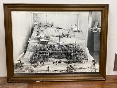
Photograph, PORT PHILLIP MINE MODEL
FRAMED PHOTOGRAPHS OF MODEL OF PORT PHILLIP & CLUNES MINE AND SIGN USED WHEN ON DISPLAY .1 PHOTO OF FULL MODEL .2 PHOTO OF BACK OF MODEL .3 PHOTO OF CLOSE UP OF BUILDING WHICH HAS NO OUTER WALLS OR ROOF TO ENABLE VIEW OF INSIDE. .4 HAND WRITTEN SIGN, FRAMED MODEL MADE IN 1858 BY CARL NORDSTROM ON SITE . MODEL NOW IN STORAGE AT SCIENCE MUSEUM OF VICTORIAlocal history, photographs, mining -
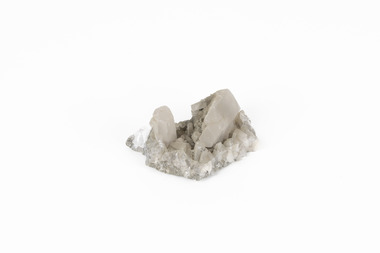 The Beechworth Burke Museum
Geological specimen - Calcite crystals
Calcite is a common mineral and is found worldwide due to it being a primary component of many other rocks such as limestone and marble. It is a softer mineral that scratches easily and is often found colourless or with a cream/white shade but may show up in colours such as red, yellow, green, and violet. In sedimentary rocks calcite is often found in the form of invertebrate shells, making it an important biomineral. Calcite is used in many industries such as farming, building, and medicine. This particular specimen was found at Broken Hill mine in Broken Hill, New South Wales, Australia. Broken Hill mine is one of the largest mines working silver and lead in Australia and at its peak employed 6500 staff across 7.5km long of land. The site was founded in 1883 by Charles Rasp, where Rasp and 6 other men from various backgrounds came together to form the first BHP mine. It has become one of the most popular mining sites due to its abundance and longevity. The ore body was created 1685 million years ago due to volcanic activity causing heated seawater to flow up through the seafloor where it mixed with the cold water creating black sulphide precipitates. These then settled back onto the seafloor forming sediment layers rich in minerals. Over time the land eroded until it was discoverable by humans.Historically this specimen is significant due to the origin of its location. Broken Hill mine has a long history in both its location and its findings and has resulted in a variety of minerals being discovered at its site. It is beneficial in the understanding of the Australian landscape over millions of years. Due to its properties, calcite today is used in a multitude of different industries such as agriculture, construction, medicine, and farming.A small sized calcium, carbon and oxygen made mineral specimen in shades cream and greycalcite, mineral, limestone, marble, sedimentary, invertebrate shells, biomineral, farming, medicine, broken hill, broken hill mine, new south wales, charles rasp, syndicate of seven, volcanic activity, black sulphide precipitates, calcite crystals, beechworth museum, indigo shire, beechworth