Showing 16872 items matching " place"
-
 Canterbury History Group
Photograph - Corner of shop No. 111 Maling Road at the corner of Maling Road and Theatre Place, Jan Pigot, 27/03/1993 12:00:00 AM
Coloured photograph of the corner of shop No. 111 Maling Road at the corner of Maling Road and Theatre Placecanterbury, maling road, shops, streetscapes -
Canterbury History Group
Photograph - View of the eastern corner shop No. 8 of Theatre Place, Jan Pigot, 27/03/1993 12:00:00 AM
Coloured photograph of the door of the shop at the eastern corner of Theatre Place called Home Sweet Homecanterbury, maling road, shops, theatre place -
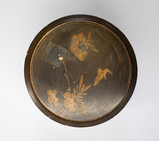 Charlton Golden Grains Museum Inc
Container - Collar Box, Circa 1900
Round Veneer Wood Collar Box. Insect Design, Bird & Flowers. Place in centre for studs -
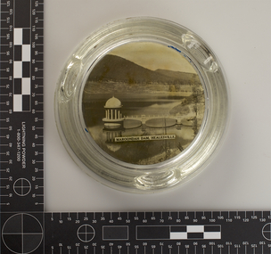 Melbourne Water
Ashtray, Maroondah Dam, Healesville Souvenir, 1930s-1940s
The Maroondah System was first and foremost developed as a functional component of Melbourne's Water Supply System. In addition to functionality, the Melbourne and Metropolitan Board of Works (MMBW) envisioned the Maroondah Reserve to be enjoyed aesthetically and recreationally by the public. This souvenir illustrates the realisation of the Maroondah System as a local recreational and tourist attraction in the early 20th century. The Maroondah Reserve gardens were landscaped with English-style ornamental stonework, exotic trees, flower beds and rose gardens. All features of the water supply system became widely celebrated as beauty spots that continue to be very popular to this day with tourists and locals alike. This souvenir is a product of that flourishing tourist trade. These water supply sites continue to enhance Melbourne’s charm and liveability and are now recognised as places of cultural and historic significance.This souvenir item has been curated by Melbourne Water as it represents an important historical aspect of the organisation by demonstrating the popularity of its water asset sites as recreational places and tourist attractions, and although these sites are functional parts of the water supply system, they were also designed to be enjoyed by the public both aesthetically and recreationally. This Souvenir glass ashtray, used as a receptacle for ash from cigarettes, features a black and white photograph of The Maroondah Dam on the base, with text reading “Maroondah Dam, Healesville”. The ashtray is round in shape with three indents on the rim to place cigarettes. melbourne metropolitan board of works, mmbw, maroondah, dam, healesville, melbourne water, scenic view, souvenir, glass, ashtray -
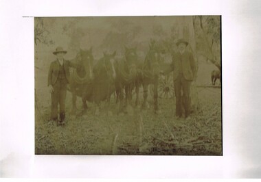 Kiewa Valley Historical Society
Photograph (Digital) Harnessing Horses, Harnessing Working Horses early 1900, early 1900s
This copy of an original photograph created in the early 1900s details the "horse and cart" era when the normal transportation of the day was, in this rural setting, exclusively by horse and cart. The importance of this particular photograph to the subjects can be seen by the formal suits worn by both subjects.The natural bush and grassed backdrop have not been "touched up". The dray behind the horses is barely visible (fog like aperture). The lad , John Cooper was 14 years old when this photograph was taken. Both were in the process of harnessing four horses to "hook up" on the dray behind them. From their attire it looks like a trip to town or "the church".This photograph of life on a rural property in the early 1900 shows the rough and hard (physically) life in rural areas before great mechanical revolution/evolution post World War II. This was a time in the Kiewa Valley when most transportation was by horse drawn carriages and transportation routes where dirt roads with potholes. The significance of a local pioneer "family" encapsulated by this photograph cannot be reproduced as effectively in any other form. This digitised scanned copy of an original photograph of four work horses is on 200gms Fujicolor (Fujifilm) Crystal Archive paper has a silver side on which the image has been printed and a matt reverse side.The darker slightly "blurred" image has had a white frame placed over it at the time of encapsulation to provide the finished photo with a frame. This method highlights and focuses the view into the photograph. It is a clever way to permit the eyes to focus into the image to give it a greater third dimensional aspect. on the reverse side hand written(in pencil) "John Cooper & Paddy Cullen (itinerant worker) on grandfathers place (opposite Nesta Drews place) (orange Grove). "Grandfather emigrated from England with Ryders""orange grove " property, early tawonga life style, john cooper, paddy cullen, harnessing working horses -
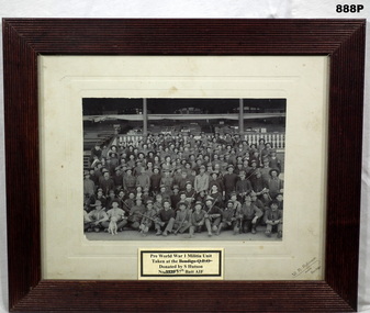 Bendigo Military Museum
Photograph - GROUP PHOTOGRAPH, FRAMED, 1912 - 1914
This item is in a collection of 11 items donated by Stan Hutson. The majority relate to Frederick Arthur William Hutson No 3539 57th Bn AIF. Refer Cat No 922 for his service history. As this photo relates to pre WW1 taken at the Bendigo Race Course it will relate to Fredericks brother, Herbert Spencer Hutson No 3540 57th Bn. Herbert had pre war service in the 67th Militia Bn in Bendigo. Herb enlisted also in the 8th Reo’s 21st Bn and also transferred to the 57th Bn same day as his brother. Pre World War I Militia Unit. Taken at Bendigo Race Course stand. Black and white portrait of irregularly dressed soldier and one white dog. They are both seated and standing. Various head dress. Their rifles are Martini - Henry single shot. There appears to be a Chaplain in the group. Group size approx. 100 soldiers. In the grand stand behind them are various pieces of kit. They are probably Bendigo's 67 Infantry in front of the Bendigo Race Course stand. The frame is varnished timber circa 1912 - 1914.“W.R.Robinson photo Bendigo” The original ticket on the front is wrong as to place of photo taken.photography-photographs/frame accessories, military-army -
Glenelg Shire Council Cultural Collection
Postcard - Postcard - Glenelg River Nelson, Victoria, n.d
Full colour postcard, showing the Glenelg River at Nelson, Victoria; river shacks on right, Nelson Store and Visitor Information Centre on left.Front: 'A Great Place to Relax' - yellow script "NELSON VICTORIA' - white print. -
 Federation University Historical Collection
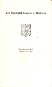
Booklet, The Worshipful Company of Musicians, 1969, 11 November, 1969
Frank Wright was a renown resident of Smeaton, where he was born on 2 August 1901. He lived at Laura Villa, and attended Smeaton State School. His father William was a gold miner and his mother's name was Sarah. Their family won many singing and instrumental awards. Frank was tutored by Percy Code and was awarded a gold medal for the highest marks in the ALCM examinations in the British Colonies at the age of seventeen years. He became the Australian Open Cornet Champion by the age of eighteen. A year later, Frank conducted the City of Ballarat Band, and later the Ballarat Soldiers’ Memorial Band. He formed the Frank Wright Frisco Band and Frank Wright and his Coliseum Orchestra. These bands won many South Street awards, and Frank as conductor won many awards in the Australian Band Championship contest. In 1933 Frank Wright sailed to England to conduct the famous St Hilda’s Band and was later appointed Musical Director of the London County Council, where he organized many amazing concerts in parks, in and around the London district. He was made Professor of Brass and Military Band Scoring and conducted at the Guildhall of Music and Drama. Frank was often invited to adjudicate Brass Band Championships around Europe, in Australia, including South Street and in New Zealand. The Frank Wright Medal at the Royal South Street competition is awarded to an individual recognized as making an outstanding contribution to brass music in Australia. In the 1960's Frank became 'The Senior Warden' of The Worshipful Company of Musicians.This is a folded, light card programme of the table seating for The Worshipful Company of Musicians celebration held at The Stationers' Hall on the 11th November 1969. Gift of Frank Ritchie, Nephew of Frank WrightPrinted with the title and emblem, place and date and the list of participant names, plus an index.frank wright, stationers' hall, worshipful company of musicians -
 Bendigo Historical Society Inc.
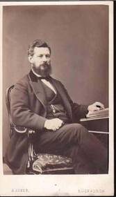
Photograph - PORTRAIT OF A MAN
Small portrait of man sitting at a desk. He has his left hand resting on a book. He is weraing a three piece suit with watch chain. Photographer's name and address printed on the back.A. Asher, 65 Princes Street and 47 Whitefield Place, Leith Walk, Edinburghphotograph, portrait, male, portrait of a man, a. asher -
 Geelong Cycling Club
Trophy, 2009
The Annual 20 Road race has been the classic championship of the Geelong Cycling Club from 1914 onwards. It was called the Annual 20 because it was originally a 20 mile race. 2009 marked the 97th running of the race. This award highlights the significance of this Road Race to the Club.Gold coloured trophy on a burgundy base. A cyclist is depicted on the top of a column with the word 1st adhered to the front of the column."Geelong Cycling Club - 2009/Annual 20/Road Race/1st Place"geelong cycling club; annual 20; road race; 1st place; -
Stawell Historical Society Inc
Souvenir, Coronation 1953
Queen Elizabeth II - Coronation SouvenirPendant - background Pale Blue - Gold Paint crown. Showing blue background in front of crossed gold paint flags, showing a blue Lion and a blue Kangaroo. Gold Paint edging. Coronation Souvenir in gold paint. End point gold paint showing blue Background 19953Brown stains, tears, and hole with fraying, gold paint partly removed in placescoronation, souvenir, pendant -
 Melbourne Tram Museum
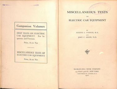
Book, Eugene C Parham, John C Shedd, "Miscellaneous Tests on Car Equipment", 1910
Book - 170 pages, 10 sections sewn and bound into heavy green card covers cloth covered with glued end pages. Title "Miscellaneous Tests on Car Equipment" for electric street car or trams written by Eugene C Parham and John C Shedd, published by McGraw Hill Book Co. of New York, dated 1910. Has a table of contents, index at the rear, and index of Rules for determining sizes of electrical equipment and tramcar horsepower and kilowatts, traction and speeds. Cover sheets, table of contents and indexes scanned to a pdf file.In a number of places "The Electric Supply Company of Victoria Limited" stamped throughout the book.trams, tramways, electrical engineering, electrical equipment, tramcars, maintenance, motors -
 Ringwood and District Historical Society
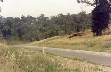
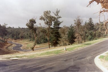
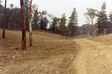
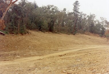
Photograph, View across junction of Wera (lower) and Manuelo (upper) Drives, North Ringwood showing how undergrowth had been cleared, February 1979
B552 N17 Part of a 51-photo record of the development of the "Kubis" Estate, Ringwood North, including road works to Debbie Place, Kubis Drive, Werac Drive, Manuelo Drive, Iluka Place and Glenvale Road. From the Jack Lundy Clarke collection. -
 Ringwood and District Historical Society
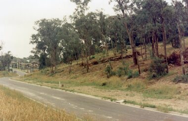
Photograph, Looking south up Werac Drive, North Ringwood past Manuelo Drive in February 1979
E552 N21 Part of a 51-photo record of the development of the "Kubis" Estate, Ringwood North, including road works to Debbie Place, Kubis Drive, Werac Drive, Manuelo Drive, Iluka Place and Glenvale Road. From the Jack Lundy Clarke collection. -
 Ringwood and District Historical Society
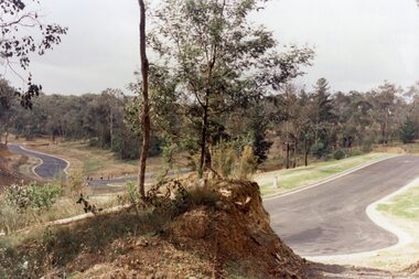
Photograph, Looking north down Werac Drive, North Ringwood with lake headwater's site behind light standard on left in February 1979
B552 N19 Part of a 51-photo record of the development of the "Kubis" Estate, Ringwood North, including road works to Debbie Place, Kubis Drive, Werac Drive, Manuelo Drive, Iluka Place and Glenvale Road. From the Jack Lundy Clarke collection. -
 Ringwood and District Historical Society
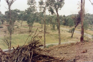
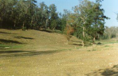
Photograph, Site of the main body of Loughnan's Lake, North Ringwood on 10 June 1978. the rope tree was on the slope, far left
E550 N6 Part of a 51-photo record of the development of the "Kubis" Estate, Ringwood North, including road works to Debbie Place, Kubis Drive, Werac Drive, Manuelo Drive, Iluka Place and Glenvale Road. From the Jack Lundy Clarke collection. -
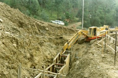
 Ringwood and District Historical Society
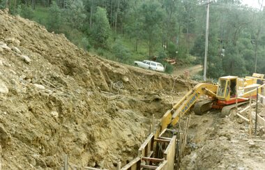
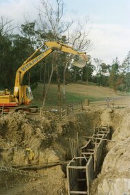
Photograph, Kubis Estate, North Ringwood on 16 June 1978, using the Kato as a crne to de-water final trench
E550 N9 Part of a 51-photo record of the development of the "Kubis" Estate, Ringwood North, including road works to Debbie Place, Kubis Drive, Werac Drive, Manuelo Drive, Iluka Place and Glenvale Road. From the Jack Lundy Clarke collection. -
 Ringwood and District Historical Society
Photograph, Kubis Estate, North Ringwood on 16 June 1978. The Kato lifts a bucket out of the trench
E550 N11 Part of a 51-photo record of the development of the "Kubis" Estate, Ringwood North, including road works to Debbie Place, Kubis Drive, Werac Drive, Manuelo Drive, Iluka Place and Glenvale Road. From the Jack Lundy Clarke collection. -
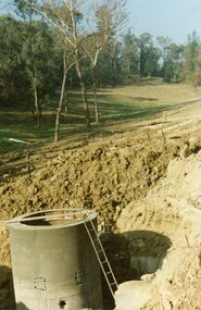 Ringwood and District Historical Society
Photograph, Kubis Estate, North Ringwood on 16 June 1978. The concrete wall 27 feet deep at the pumping station in Glenvale Road
E550 N12 Part of a 51-photo record of the development of the "Kubis" Estate, Ringwood North, including road works to Debbie Place, Kubis Drive, Werac Drive, Manuelo Drive, Iluka Place and Glenvale Road. From the Jack Lundy Clarke collection. -
 Ringwood and District Historical Society
Photograph, Kubis Estate, North Ringwood in February 1978. The site of Loughnan's Lake seen from the north end of the wall. The rope tree was on the hillside on the left
E546 N2 Part of a 51-photo record of the development of the "Kubis" Estate, Ringwood North, including road works to Debbie Place, Kubis Drive, Werac Drive, Manuelo Drive, Iluka Place and Glenvale Road. From the Jack Lundy Clarke collection. -
 Ringwood and District Historical Society
Photograph, Kubis Estate, North Ringwood on 16 June 1978. Kato working on final trench. The hole for the 27 feet deep well is seen beyond the trench
E550 N10 Part of a 51-photo record of the development of the "Kubis" Estate, Ringwood North, including road works to Debbie Place, Kubis Drive, Werac Drive, Manuelo Drive, Iluka Place and Glenvale Road. From the Jack Lundy Clarke collection. -
 Ringwood and District Historical Society
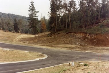
Photograph, Kubis Estate, North Ringwood in April 1978. View east up Kubis Drive from Jenkin Close past the foot of Werac Drive
E549 N16 Part of a 51-photo record of the development of the "Kubis" Estate, Ringwood North, including road works to Debbie Place, Kubis Drive, Werac Drive, Manuelo Drive, Iluka Place and Glenvale Road. From the Jack Lundy Clarke collection. -
 Ringwood and District Historical Society
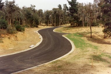
Photograph, Kubis Estate, North Ringwood in April 1978. View east up Kubis Drive over Jenkin Close and intersection with Werac Drive
E549 N18 Part of a 51-photo record of the development of the "Kubis" Estate, Ringwood North, including road works to Debbie Place, Kubis Drive, Werac Drive, Manuelo Drive, Iluka Place and Glenvale Road. From the Jack Lundy Clarke collection. -
 Ringwood and District Historical Society
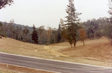
Photograph, Kubis Estate, North Ringwood in April 1978. Looking west across Kubis and Werac Drives over the full length of Loughnan's Lake site. Main pool was behind the lone pine
E548 N29 Part of a 51-photo record of the development of the "Kubis" Estate, Ringwood North, including road works to Debbie Place, Kubis Drive, Werac Drive, Manuelo Drive, Iluka Place and Glenvale Road. From the Jack Lundy Clarke collection. -
 Ringwood and District Historical Society
Photograph, Kubis Estate, North Ringwood in April 1978. Looking up the hill in Kubis Drive from the site of headwaters of Loughnan's Lake. Jenkins Close takes off to the right from centre
E548 N31 Part of a 51-photo record of the development of the "Kubis" Estate, Ringwood North, including road works to Debbie Place, Kubis Drive, Werac Drive, Manuelo Drive, Iluka Place and Glenvale Road. From the Jack Lundy Clarke collection. -
 Ringwood and District Historical Society
Photograph, Kubis Estate, North Ringwood in April 1978. Looking upstream from below the retaining wall of Loughnan's Lake that was where the truck tracks disappear. The wall was extended to the left across what was then a small gorge
E548 N19 Part of a 51-photo record of the development of the "Kubis" Estate, Ringwood North, including road works to Debbie Place, Kubis Drive, Werac Drive, Manuelo Drive, Iluka Place and Glenvale Road. From the Jack Lundy Clarke collection. -
 Ringwood and District Historical Society
Photograph, Kubis Estate, North Ringwood in April 1978. Looking west over site of Loughnan's Lake. The rope tree was on the slope to the right beyond the ridge with the lone pine
E548 N15 Part of a 51-photo record of the development of the "Kubis" Estate, Ringwood North, including road works to Debbie Place, Kubis Drive, Werac Drive, Manuelo Drive, Iluka Place and Glenvale Road. From the Jack Lundy Clarke collection. -
 Ringwood and District Historical Society
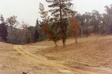
Photograph, Werac Drive, North Ringwood, entrance to Bel-Air Country Club in April 1978
E548 N11 Part of a 51-photo record of the development of the "Kubis" Estate, Ringwood North, including road works to Debbie Place, Kubis Drive, Werac Drive, Manuelo Drive, Iluka Place and Glenvale Road. From the Jack Lundy Clarke collection. -
 Ringwood and District Historical Society
Photograph, Loughnan Lake site over Kubis Drive, North Ringwood, on 14 April 1978. The retaining wall was where the car tracks disappear over the ridge where the spillway was
E548 N13 Part of a 51-photo record of the development of the "Kubis" Estate, Ringwood North, including road works to Debbie Place, Kubis Drive, Werac Drive, Manuelo Drive, Iluka Place and Glenvale Road. From the Jack Lundy Clarke collection. -
 Ringwood and District Historical Society
Photograph, "Kubis Estate", North Ringwood, in April 1978. Looking north-east over Loughnan's Lake greatest width. The rope tree was on the slope in the centre. The spillway was on the near left of the image
E548 N17 Part of a 51-photo record of the development of the "Kubis" Estate, Ringwood North, including road works to Debbie Place, Kubis Drive, Werac Drive, Manuelo Drive, Iluka Place and Glenvale Road. From the Jack Lundy Clarke collection.