Showing 2413 items
matching street parade
-
 Lakes Entrance Regional Historical Society (operating as Lakes Entrance History Centre & Museum)
Photograph, Holding M, 2009
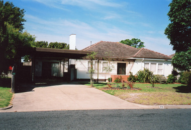
Dr Robert Hughes had a well set up surgery in what may have been originally a garage beside the family home, during 1970 - 1980's. Later resident converted surgery to a flat.Colour photograph of a timber dwelling with tiled hip roof. Brick chimney has been cement rendered. Windows on each side of central front entry have pictured window in centre of sash windows, at 20 Devitt Street Lakes Entrance Victoriahouses, heritage study -
 Lakes Entrance Regional Historical Society (operating as Lakes Entrance History Centre & Museum)
Photograph, Holding M, 1999
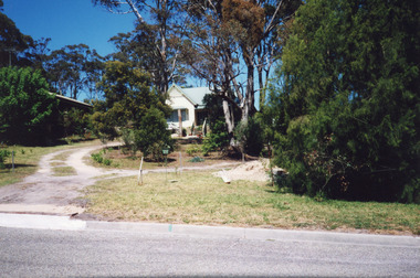
Appears to have been relocated from unknown site, more research required.Colour photograph of a timber dwelling. Has high pitched corrugated iron roof, decorative timber frieze under pitch of gable over front room. Steps leading up to veranda. Set in native vegetation, at 6 Worcester Street, Lakes Entrance Victoriaaccommodation, houses, heritage study -
 Lakes Entrance Regional Historical Society (operating as Lakes Entrance History Centre & Museum)
Photograph, 1999
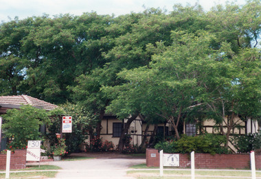
Built by Dud Conduit 1960c. Owners Bob & Karen Lewendon.Colour photograph of a group of two bedroom holiday cabins, known as Homelea Flats, with entrances from both Roadknight Street and Esplanade. Cabins and residence clad in fibro cement, lathes over joins painted to represent mock Tudor. Clay tile hip roofs. Ground planted with deciduous trees. Lakes Entrance Victoriawaterways, accommodation -
 Lakes Entrance Regional Historical Society (operating as Lakes Entrance History Centre & Museum)
Photograph, Holding M, 2009
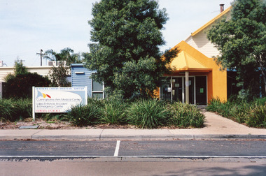
Date made September 2009|Site / building was originally (games room) part of caravan park|Also one other colour photograph closer view of front entrance doorway.Colour photograph of the front entry to Cunninghame Arm Medical Centre at 8 Whiters Street. Appears to be brick or concrete slab facade painted bright yellow. Information sign in native plant garden, brick pathways. Lakes Entrance Victoriaentertainment, transport -
 Lakes Entrance Regional Historical Society (operating as Lakes Entrance History Centre & Museum)
Photograph, Gibson, Tim, 1998
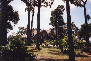
Built 1987c by American businessman in Cape Cod style, builder unknown, was barge superintendent for McDermott's.|Also three other colour photographs, groups of people in outside courtyard, and inside at tables for luncheon.Colour photograph of The Gables, a large multi-gabled dwelling of red brick with tiled roof, dormer windows in upper storey at 1 - 9 Creighton Street. Developed as Bed and Breakfast accommodation by Bruce and Maureen Livingstone between 1994 and 2004. Surrounded by landscaped gardens. Kalimna Lakes Entrance Victoriahouses -
 Lakes Entrance Regional Historical Society (operating as Lakes Entrance History Centre & Museum)
Photograph, 1999
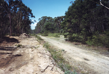
Also three other photographs taken at siding of Colquhoun Railway Siding, donated by Jan McDougall in 2000Colour photograph taken at the site of the previous Colquhoun Railway siding, showing the position of the dismantled track and some sleeper remains, surrounded by young growth forest and scrub. East Gippsland Victoriaroads and streets -
 Lakes Entrance Regional Historical Society (operating as Lakes Entrance History Centre & Museum)
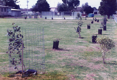
Photograph, Holding M, 2006
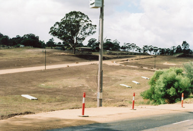
Property and subdivision believed to have been done by Bill and Kaye Reddenbach.Colour photograph of early stage of residential development showing roadways formed through property, drainage pipes placed ready for installation, street lighting in place. Photograph taken from school, looking east. Swan Reach Victoriahouses, heritage study -
 Lakes Entrance Regional Historical Society (operating as Lakes Entrance History Centre & Museum)
Photograph, Bulmer H D, 1940c
Black and white photograph of aerial view of township. It shows route of Princes Highway through town, turning north at Myer Street and continuing along Roadknight Street. Few jetties on North Arm, many on Cunninghame Arm. In far upper left of image sea is breaking on sand hummocks. Lakes Entrance Victoriawaterways, vegetation, boats and boating -
 Lakes Entrance Regional Historical Society (operating as Lakes Entrance History Centre & Museum)
Photograph, 1930c
This is the before photograph used in the 150 year Lakes Entrance 1858 - 2008 display.Black and white panoramic photograph showing the township, taken from Allens Hill at the top of Myers Street. It shows the town between Cunninghame Arm and North Arm, on the western side Bernies Point. Allens Hill now known as Butchers Paddock. Lakes Entrance Victoriawaterways, vegetation -
Lakes Entrance Regional Historical Society (operating as Lakes Entrance History Centre & Museum)
Photograph, 2008
Date made August 2008|This is the paired after photograph used in the 150 year Lakes Entrance 1858 - 2008 display.Colour panoramic photograph of the township, from Allens Hill at top of Myer Street. It shows the town between Cunninghame Arm and North Arm known as Butchers Paddock. Lakes Entrance Victoriajetties, waterways, topography, boats and boating -
 Lakes Entrance Regional Historical Society (operating as Lakes Entrance History Centre & Museum)
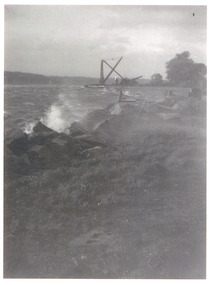
Photograph, 1954
Black and white photograph showing rough water lashing foreshore west of entrance, walings and crane middle distance on right, waves splashing on rocks in foreground, photo taken near Schnapper Cottage, Hopetoun channel, Lakes Entrance, Victoria.jetties, roads and streets, aerial photograph, township, waterways -
 Lakes Entrance Regional Historical Society (operating as Lakes Entrance History Centre & Museum)
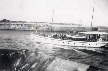
Photograph, 1930c
Black and white photograph showing Symes boat, Westwind, motoring into the entrance from Bass Strait, Eastern pier on far side of boat, photo taken from western pier, Lakes Entrance, Victoria.aerial photograph, islands, roads and streets, waterways, township -
 Lakes Entrance Regional Historical Society (operating as Lakes Entrance History Centre & Museum)
Postcard, Bulmer H D, 1922c
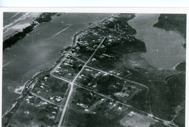
Black and white photographic postcard, showing early aerial view of township of Lakes Entrance, Cunninghame Arm, North Arm and sand dunes, ocean in lower foreground, Eastern wharf and various boats on lake. Princes Highway went along Esplanade, Myer Street and Roadknight Street, very little vegetation on sand dunes, no foot bridge yet, good view of North Arm, few houses. Lakes Entrance VictoriaLakes Entrance and Backwater from the Air.islands, aerial photograph, waterways, topography, township -
 Lakes Entrance Regional Historical Society (operating as Lakes Entrance History Centre & Museum)
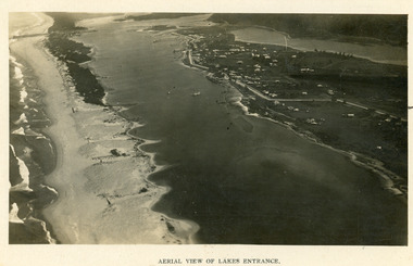
Photograph, 1923c
Two copies 16.5 x 25.5 very darkBlack and white photograph showing early aerial view of township of Lakes Entrance, photo shows highway going along Myer Street and along Roadknight Street, no shops in Myer Street appears to be no foot bridge, therefore taken prior to 1937, sparce vegetation on foreground dunes, four barriers built on dunes to stop erosion through sand, two masted sailing boat in lake. Bullock Island in distance appears very small, Snake Island of Rigby Island in centre distance. Lakes Entrance VictoriaAerial View of Lakes Entrancewaterways, coast, aerial photograph, islands -
 Lakes Entrance Regional Historical Society (operating as Lakes Entrance History Centre & Museum)
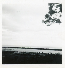
Photograph, Fraser, Nancy, 1970c
Black and white photograph of a distant view township and Cunninghame Arm and scrub covered hummocks of southern shore in distance. Lakes Entrance Victoriaislands, jetties, topography, waterways, roads and streets -
 Lakes Entrance Regional Historical Society (operating as Lakes Entrance History Centre & Museum)
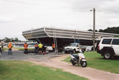
Photograph, Holding M, 2011
Three other similar photographsColour photograph of an aluminium catamaran hull being prepared for launch in the North Arm, prior to having all superstructure built believed to be Calypso Star. Lakes Entrance Victoriawaterfront, bridges, roads and streets -
 Lakes Entrance Regional Historical Society (operating as Lakes Entrance History Centre & Museum)
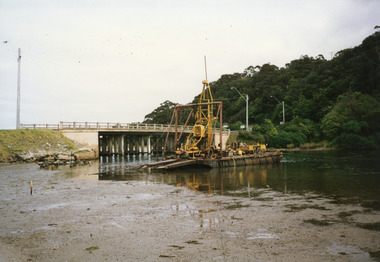
Photograph, 2000
Date made 2 October 2000Colour photograph of the pontoon testing for foundations for proposed new bridge over North Arm water, old bridge Kalimna side. Lakes Entrance Victoriabridges, roads and streets, machinery -
 Lakes Entrance Regional Historical Society (operating as Lakes Entrance History Centre & Museum)
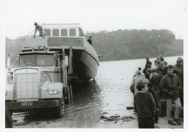
Photograph, Shepherd, Dennis, 1975
Owners John and Pam Guillot|Also second photograph black and white showing it at the boat ramp being launchedBlack and white photograph of the launching of the fishing boat Southern Cross in North Arm. The boat is shown in Roadknight Street being towed by semi-prime-mover. Lakes Entrance Victoriaboats and boating, fishing industry -
 Lakes Entrance Regional Historical Society (operating as Lakes Entrance History Centre & Museum)
Photograph, 1999
John B Carpenter left 100 pounds in his Will to enable the Tambo Shire Council to plant this avenue in memory of John Carpenter, see Item 18 in Tambo Shire Council Minutes, 15 August 1967.Colour photograph of the avenue of Queensland Box trees, Tristiana conferta, in Roadknight Street, planted as a memorial to John Carpenter, early settler of Gippsland and main contractor of the building of the man made entrance through to the sea. Lakes Entrance Victoriapublic utilities -
 Lakes Entrance Regional Historical Society (operating as Lakes Entrance History Centre & Museum)
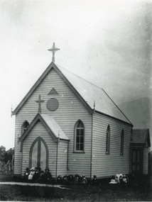
Photograph, 1900 c
Photo taken of original church site, south corner of Church and Mechanics Streets, before removal and enlargement on north corner of streets.Black and white photograph of St Nicholas Anglican Church, showing timber building with porch at front and vestry at rear. Main building, vestry and porch have high pitched gable roofs with cross apex, window each side of porch, two windows at side of church, upper arched panes open. Two ventilators, one triangular, one circular in wall above porch. About eighteen children seated on ground. Lakes Entrance VictoriaOriginal Ch 1898 removed, rededicated 1908religion, clothing -
 Lakes Entrance Regional Historical Society (operating as Lakes Entrance History Centre & Museum)
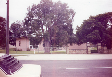
Photograph, 1992
Also one other copy donated by Vera Bennett, and one other copy taken by Olav Doderlund, donated by Glenice Soderlund.Colour photograph of the concrete brick St Nicholas Anglican Church on corner of Church and Mechanics Streets, Lakes Entrance.celebrations, religion -
 Lakes Entrance Regional Historical Society (operating as Lakes Entrance History Centre & Museum)
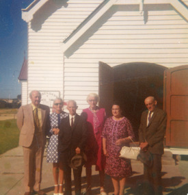
Photograph, 1960 c
Taken at front of St Brendans Church Street, showing Bob and Bell Field, Jack and Dot Field, Terry and Pat Ledwith. Lakes Entrance Victoriabuildings, religion -
 Lakes Entrance Regional Historical Society (operating as Lakes Entrance History Centre & Museum)
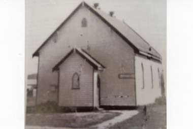
Photograph, 1950
This was photocopied from book 'The Story of Two Mustard Seeds''.Black and white photograph of St Aidens Presbyterian Church which was situated in Mechanics Street, Lakes Entrance Victoriabuildings, religion, room display -
 Lakes Entrance Regional Historical Society (operating as Lakes Entrance History Centre & Museum)
Photograph, 1924
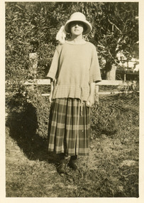
Miss Catt boarded in Roadknight Street, Lakes Entrance, in 1924, and walked all the way to Bunga Creek school from Lakes Entrance.Black and white photograph showing Miss Catt, teacher at Bunga Creek Primary School No. 336, East Gippsland. Bunga Creek Victoriaschools -
 Lakes Entrance Regional Historical Society (operating as Lakes Entrance History Centre & Museum)
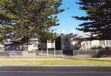
Photograph, 2008
This is the after photograph used in the 150 year Lakes Entrance 1858 - 2008 display held in 2008.Colour photograph of the facade of the Lakes Entrance Primary School situated on Myer Street. Lakes Entrance Victoriaschools -
 Lakes Entrance Regional Historical Society (operating as Lakes Entrance History Centre & Museum)
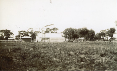
Photograph
Black and white photograph showing the back of Lakes Entrance State School, Myer Street, water tank on tall stand behind main building, a small building to one side possibly shelter shed, also cottage across the road. Lakes Entrance Victoriaschools -
 Lakes Entrance Regional Historical Society (operating as Lakes Entrance History Centre & Museum)
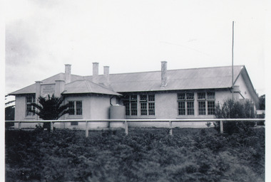
Photograph, 1939
Young palm tree in front of schoolBlack and white photograph showing Lakes Entrance State School, Myer Street, with young palm tree in front of school. Lakes Entrance Victoriaschools -
 Lakes Entrance Regional Historical Society (operating as Lakes Entrance History Centre & Museum)
Photograph, Tidy Town Com, 1994
Colour photograph of south east corner of Primary School yard, looking towards Myer Street, showing recently planted Australian Native trees.Lakes Entrance Victoriaschools -
 Lakes Entrance Regional Historical Society (operating as Lakes Entrance History Centre & Museum)
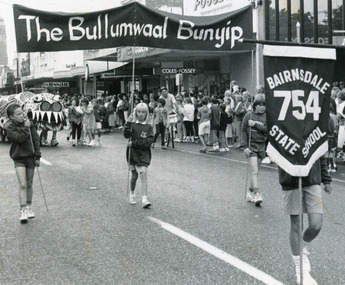
Photograph, Lakes Post Newspaper, 1991
Black and white photograph of four students from Bairnsdale State School No 754, leading the Bullumwaal Bunyip, their entry in Bairnsdale Mardi Gras parade 1991. In background crowds are gathered on Main Street outside businesses Sussan, Williams the Shoeman and Coles-Fossey, watching the procession. Bairnsdale Victoriaschools -
 Hume City Civic Collection
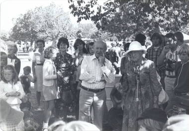
Photograph, Sunbury Fair c 1977, c1977
The photograph was taken at the Sunbury Fair possibly in 1977 when Bert Kelly, who is the man in the foreground, was the Shire President. Every year in March the Shire of Bulla held the fair in which community groups participated in a parade in the morning and the afternoon was given over to entertainment by local groups and displays on the Village Green. The lady, wearing a dark patterned dress and standing immediately behind Bert Kelly is Shirley McKerrow. Mrs Mommsen is standing next to him and the young man 2nd from extreme right is Graham Gibb. Her husband, Frederick Christian Mommsen was a former Shire of Bulla councillor.The Sunbury Fair was a popular annual event that took place in Sunbury and allowed local groups to participate.A black and white photograph with rounded corners of a group of people in a parkland. gathered around an elderly lady and a man. bert kelly, sunbury fair, village green, shirley mckerrow., graham gibb, mrs. mommsen