Showing 1240 items
matching common school
-
 Wodonga & District Historical Society Inc
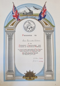
Certificate - Recognition of Service World War II - Ian Darnton Watson, 1946
Ian Darnton Watson was a member of a prominent family of civic leaders in Wodonga. He was born on 6th July 1925 in Albury, the first son of Kenneth Darnton Watson and Phyllis Lenore Emily Austin. He completed his primary education at Albury Grammar School, and later became a boarder at Melbourne Church of England Grammar School. He enlisted for service at Albury on 25th January 1944 and commenced full time service on 8th February 1944 at Royal Park in Melbourne, Victoria and was allocated to the 2nd Medium Regiment. He embarked for overseas service in Borneo on 30th July 1945 and disembarked in Australia on 15 April 1947 after serving with the Australian occupation forces in Japan. Mr Watson was discharged on 22 April 1947 at which time he was a member of the Australian 2nd Medical Regiment. On discharge he returned home to help his father farm his property, De Kerilleau in Wodonga. De Kerilleau was classified by the National Trust in 1974. Ian described his father, Kenneth as a hardworking, practical man, who for two years from 1929 - 1931, had been the Wodonga Shire President. Cr K. D. Watson was again elected to the Council in 1943 and served until he died in October 1951. In March 1957, he married Miss Lesley Buttfield, of Sydney, NSW. They had three children, Fiona, John and Rowena. John was later to become a member of Wodonga Council and served as mayor. Ian was past President of the RSL branch at Wodonga, Captain of the Wodonga Rural Fire Brigade, and President of the West Wodonga Primary School Committee. He also served on Wodonga Council from 1974 until his death on 14 December 1981, aged 56.This certificate is significant because it acknowledges the War Service of a prominent member of the Wodonga communityA colour printed certificate presented to Ian Darnton Watson in appreciation for his service for "King and Empire" during World War II. The text is surrounded by columns and an arch. The Australian and British flags are at the top as well as representations of the Navy, Army and Air Force. It also features the logo of the Shire of Wodonga above the text. The badge of the Commonwealth Armed Forces is at the centre bottom of the certificate. This small collection also includes black and white photographs of Ian Watson from his Service Records and another photo in uniformOn Certificate: PRESENTED TO Ian Darnton Watson BY THE PRESIDENT, COUNCILLORS AND CITIZENS OF THE SHIRE OF WODONGA as a record and an appreciation of Your Services to King and Country during the Great War which commenced 3rd September, 1939. Given under the Common Seal of the Shire of Wodonga by the President, Citizens this Councillors and Citizens this 26th day of February 1947watson family wodonga, ian darnton watson, de kerilleau -
 City of Kingston
Photograph - Colour, Circa 1993
Edithvale is a suburb in the City of Kingston. It is located between Aspendale and Chelsea on the Port Phillip Bay and built within remnant areas of the Carrum Carrum swamp. The foreshore precinct comprises a wide sandy beach, with low sand dunes and numerous historic boat sheds. The suburb consists of older style dwellings and former holiday houses, combined with mid-century housing and newer homes. The large blocks are increasingly subdivided and the existing dwellings demolished to accommodate units and townhouses, thus changing the landscape of the area and reducing the tree canopy.The beachside suburb of Edithvale was previously part of the extensive Carrum Carrum Swamp. The area was once a source of fish and eels for the Mayone-Bulluk clan of the Bunurong people. Over time the area was drained and predominantly devoted to dairy farming and holiday houses. The farms were gradually sold and subdivided with a large number of homes built after World War II and in the 1960s. Edithvale is mainly residential with a shopping strip along Nepean Highway but little significant industry was ever established in the area apart from a plaster works and confectionary factory, both now closed.Aerial colour photograph of Edithvale as viewed from Alexandra Avenue in the north to Ella Grove Chelsea/Edithvale in the south. The area is built-up with residential housing and facilities including Edithvale Primary School, numerous churches and the Edithvale Railway station. Large sections depict the remnant Carrum Carrum swamp. Edithvale Common and the former "Duck Inn" (Melbourne Water/Friends of Edithvale Seaford Wetlands) can be seen. Edithvale Recreational reserve, the valodrome and Edithvale Public Golf Course are prominent. The image shows vacant land in the area now known as Aspendale Gardens and the newer residential section of Chelsea Heights is not developed. A bike path has been established to cover the secondary drain. The Golf Links Court residential development located off Hughes Avenue is a large vacant block.Yellow circular adhesive sticker on plastic Black ink (marker): * (asterisk) Black type on white adhesive sticker: P000108edithvale, aspendale, chelsea, carrum carrum swamp -
City of Kingston
Photograph - Colour, 6 March 1993
Edithvale is a suburb in the City of Kingston. It is located between Aspendale and Chelsea on the Port Phillip Bay and built within remnant areas of the Carrum Carrum swamp. The foreshore precinct comprises a wide sandy beach, with low sand dunes and numerous historic boat sheds. The suburb consists of older style dwellings and former holiday houses, combined with mid-century housing and newer homes. The large blocks are increasingly subdivided and the existing dwellings demolished to accommodate units and townhouses, thus changing the landscape of the area and reducing the tree canopy.The beachside suburb of Edithvale was previously part of the extensive Carrum Carrum Swamp. The area was once a source of fish and eels for the Mayone-Bulluk clan of the Bunurong people. Over time the area was drained and predominantly devoted to dairy farming and holiday houses. The farms were gradually sold and subdivided with a large number of homes built after World War II and in the 1960s. Edithvale is mainly residential with a shopping strip along Nepean Highway but little significant industry was ever established in the area apart from a plaster works and confectionary factory, both now closed.Laminated aerial colour photograph of Edithvale as viewed from Alexandra Avenue in the north to Ella Grove Chelsea/Edithvale in the south. regents Park Aspendale can be seen in the top left. The area is built-up with residential housing and facilities including Edithvale Primary School, numerous churches and the Edithvale Railway station. Large sections depict the remnant Carrum Carrum swamp. Edithvale Common and the former "Duck Inn" (Melbourne Water/Friends of Edithvale Seaford Wetlands) can be seen. Edithvale Recreational reserve, the valodrome and Edithvale Public Golf Course are prominent. The image shows vacant land in the area now known as Aspendale Gardens and the newer residential section of Chelsea Heights is not developed. A bike path has been established to cover the secondary drain. The Golf Links Court residential development located off Hughes Avenue is a large vacant block.Black type on white adhesive label: 6-3-93 Black type on white adhesive label: 25/9211, 6/3/93, 11.20 am Black type on white adhesive label: 9211 Yellow circular adhesive sticker Black pencil: 9211 6-3-93 arrow pointing Nedthvale, carrum carrum swamp, aspendale, chelsea -
 Melbourne Legacy
Document, Why I founded the Somers Camp, 1933
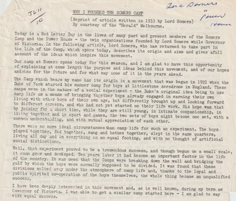
A typed reprint of an article that appeared in The Herald. It is an account of the founding of Somers Camp by Lord Somers. The camp began in 1921 when the Duke of York started a summer camp for boys at Littlestone Aerodrome in England. It was an experiment in bringing together boys from different walks of life to encourage understanding and mutual appreciation of each other. While Lord Somers was Governor of Victoria he started a similar camp here with equal success. Part of the text: "Our aim is to change and improve the mental attitude of the boys to each other — to beget a state of mind in which the two sets merge in each other. As the period of the Camp is short — only one week — every effort is made to give the boys full scope for recreation and play. We do not wish to give them a busman's holiday and saddle them with numerous domestic duties, and so they are free of nearly all these, and can devote the whole of their time to themselves. We wish, too, to give them absolute freedom, with as little hampering discipline as possible, and so long as the simple rules of the Camp, such as punctuality at meals and so on are observed, they can do what they like. The Group Leaders take charge of the organised sports, and as each group is composed of boys from both school and workshop, unity is preserved. Superficial differences in worldly pros perity vanish at the Camp; you can't tell one from t'other; a feeling of comradeship in a common life manifests itself; a spirit of loyalty to each other, and to the ideals behind the camp quickly emerges; artificial barriers tumble down, and we are all one, That, in brief, is the spirit of the Camp. But, of course, that is not the beginning and end of it, for if it were, the benefit would be merely temporary, and the effects would pass off. And so I come to the other and, to my mind, the more important function of the movement which finds expression in what we call the Power House. The Power House is a continuation of the Camp. Every boy who attends the Camp becomes automatically a member of the Power House. The Camp is the Open Sesame to the Power House, and whereas in the Camp the boy has merely enjoyed himself, when he graduates to the Power House he begins to imbibe the spirit of service and to learn that he has responsibilities, both to himself and to others. The Power House has already taken concrete form in the shape of a building in the Albert Park which constitutes a sort of headquarters."A record of the camp at Somers in the words of the founder.Foolscap page x 2 of black type of an article in the HeraldHandwritten 'JL11/10' in black pen, 'Lord Somers and Power House' in blue pen.camp, lord somers camp, lord somers -
 Surrey Hills Historical Society Collection
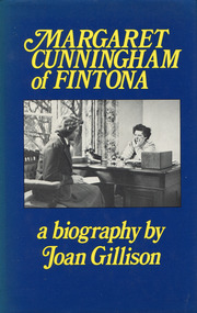
Book - Margaret Cunningham of Fintona: a biography by Joan Gillison, 1982
The subject of this biography is a redoubtable and unusual woman. Born in 1900, Margaret Cunningham was educated at Clyde and Melbourne University where she took a science degree, not a common choice for women in those days; then, after a time as welfare superintendent at a large department store, she went to London to train as a teacher. Back in Melbourne she joined the staff of Fintona, a girls' school which she later bought and transferred to a new site. From 1936 to 1962 in partnership with deputy principal Miss Beatrice Chilvers, she shaped a school which tried to make the most of every student's talents and fostered co-operation and goodwill among staff and pupils.A 22 cm H book with 231 p, and includes an index, appendix and notesnon-fictionThe subject of this biography is a redoubtable and unusual woman. Born in 1900, Margaret Cunningham was educated at Clyde and Melbourne University where she took a science degree, not a common choice for women in those days; then, after a time as welfare superintendent at a large department store, she went to London to train as a teacher. Back in Melbourne she joined the staff of Fintona, a girls' school which she later bought and transferred to a new site. From 1936 to 1962 in partnership with deputy principal Miss Beatrice Chilvers, she shaped a school which tried to make the most of every student's talents and fostered co-operation and goodwill among staff and pupils.cunningham, 1900-, fintona girls' school, teachers -- victoria -- melbourne -- biography, margaret cunningham -
 Buninyong Visitor Information Centre
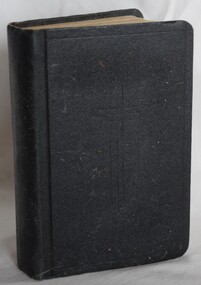
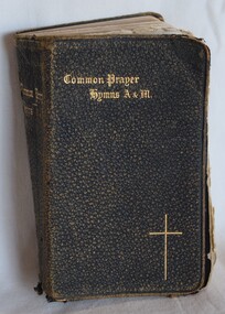
Book, The Book of Common Prayer - The Church of England
Example of presentation made at the Anglican Church's Sunday School in Buninyong in the 1920s.Small black covered book with a cross indented on the front cover. No name on cover.To Martha Challis from Holy Trinity Sunday School, Buninyong, June 28, 1926.christianity, anglican church, prayer -
 Buninyong Visitor Information Centre
Book - Prayer Book, William Clowes and Sons Limited, Book of Common Prayer, Hymns Ancient and Modern, c.1900
The prayer book was presented by the Holy Trinity Church in Buninyong to Blanche Brown in 1900.Small black stippled leather covered prayer book with gold embossed title and cross on the front cover.Written inside front cover: 'Blanche Brown, 1st Prize, Senior Girl's Class, Holy Trinity Sunday School, 1900'.religion, christianity, buninyong holy trinity church, prayer books -
 Wooragee Landcare Group
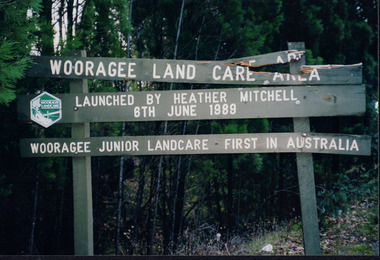
Photograph, 2004
This photograph of the Wooragee Landcare Area signage was included in the album alongside the statement that, when the photo was taken in 2005, the Wooragee Landcare Group had applied for a council grant for new sifgns with which they could replace the broken sign in the photograph. The sign marks the Woooragee Landcare Area, opened in 1989 by Heather Mitchell, one year after the first meeting of the Wooragee Landcare Group. It also commemorates the 1898 founding of Wooragee Junior Landcare, which they launched with Wooragee Primary School. As stated by the sign, Wooragee Junior Landcare was the first group of its kind in Auatralia, with the nation-wide Junior Landcare organization being launched in 1998. This photograph is significant as a marker of Wooragee Landcare's need for grants and council funding, which is common to many organisations, and for demonstrating the history of Wooragee Landcare and Junior landcare by commemorating the founding of both the Wooragee Landcare Area and Wooragee Junior Landcare. Rectangular landscape colour photograph printed on gloss photographic paper.Obverse: Sign in photograph reads "Wooragee Land Care Area/ Launched by Heather Mitchell/ 6th June 1989/ Wooragee Junior Landcare First in Australia" Reverse: "WAN NA E0NA0N2. AIN+ 1 2906/ -
 Warrnambool and District Historical Society Inc.
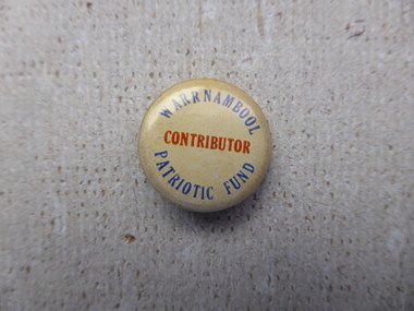
Badge - Warrnambool Patriotic Fund
The Warrnambool Patriotic fund was established by the Council under the Mayor at the time, A Fritz Landmann, in 1914 to aid the efforts of the first World War. Most towns across Australia had similar fund raising ventures. People and groups were encouraged to subscribe money as well as donations of food and clothing to be sent to soldiers and overseas groups. The Mayoress and the State Schools also had funds at the time along similar lines. A small item which would have been common at the time which links Warrnambool to the major event of the time. Small cream coloured round badge with navy blue writing around the rim and red text in the middle.warrnambool, warrnambool patriotic fund, fritz landmann warrnambool 1914, world war one, warrnambool -
 Federation University Historical Collection
Book, Final recommendations Ballarat Study Area Land Conservation Council, Victoria, 1982, 1982
Yellow soft covered report of 95 pages . The contents of the report include: Parks, reference areas, wildlife reserves, water production, harwood production, softwood production, flora Reserves and Flora and Fauna reserves, bushland reserves, historic area and reserves, rivers and streams, Roadside conservation and Highway parks, Education areas and School Plantations, Lake Reserves, geological reserves, recreation, scenic reserves, agriculture, mineral and stone production, utilities and survey, township land, Uncommitted Land, military training, other reserves and public land. Maps include: The Study area 1: 250 000 Supplementary Mapsland conservation authority, ballarat, endowment plantations, pine plantations, langi ghiran state park, mount buangor state park, enfield state park, ballarat-creswick regional park, rossbridge, black lake, flax mill swamp, dereel lagoon, lake bolac, lake wongan, langi ghiran reservoir, gong gong reservoir, pincotts reservoir, beales reservoir, wilsons reservoir, moorabool reservoir, korweinguboora, korweinguborra reservoir, learmonth bores, sago hill, illabarook reservoir, ballarat water commission, dunneworthy, mount cole, mont lonarch, ben major, waterloo, trawalla, linton, ross creek, canadian, shepherds flat, lal lal, mount doran, raglan, chute, carngham, buninyong, watsons hill, enfield, cape clear, illabrook, rokewood junction, mount warrenheip, nerrina, jubilee, golden stream, australasian deep lead mine, happy valley school, piggoreet, berringa, bulldog, ballarat common, wildlife, water, timber, flora, rivers, geology, agriculture, warrenheip, biodiversity